Global Change Data Encyclopedia
Gahai Lake, Qinghai-Tibet Plateau (Delingha), China
Gou, Z. J. Liu, F. G.*
Department of Geographic Sciences, Qinghai Normal University, Xining 810008, China
Keywords: Gahai Lake; Qinghai-Tibet Plateau; Delingha city; Qinghai province; salt water lake; data encyclopedia
|
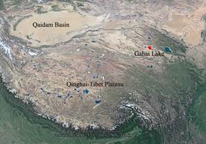
Figure 1 Geo-location of the Gahai Lake (Google Earth image)
|
Gahai Lake, also called Balkhazinor which was transliterated from Mongolian language with the mean of “Small black lake”, is located at the northeast corner of Qaidam Basin in the northeast of the Qinghai-Tibet Plateau. It is 25 km away from Delingha city, Haixi Mongolian autonomous prefecture, Qinghai province[1]. It is an enclosed salt water lake on the plateau, with an elevation of 2,851 m. The geo-location of the Lake is 37°05′58″N-37°10′00″N, 97°31′05″E-97°35′47″E, with the central location at 37°07′30″N, 97°33′03″E (Figure 1, Figure 2).
The Gahai Lake is in the Delingha-Xiligou basin, northeast of Qaidam Basin, which was formed by faulting in geology. Zongwulong Mountain, the south offset in the mid of Qilian Mountain, is in the north of the Lake, while the Nanshan Mountain (4,472 m) and Maoniu Mountain (3,947 m) are in the south of the Lake from west to east. Gahai Lake is connected by intermittent rivers to Keluke Lake and Toso Lake at its west, and it is connected to Salt Lake Keke by rivers at its east[2].
|
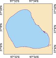
Figure 2 Data map of the Gahai Lake (.shp format)
|
The Lake is 7.1 km long from east to west, and 5.9 km wide from north to south. The area of the Lake (2015) is 33.46 km2, and the shoreline is 28.20 km[3], with the average water depth of 2.7 m. The Lake is in the desert and semi-desert arid climate zone, with annual average temperature of 3.0 oC, annual average precipitation of 126.6 mm (Table 1), annual average evaporation of 2,242.8 mm, and the solar radiation of 166 kcal/cm2. There is no perennial surface runoff recharge, so the water mainly depends on seasonal precipitation and groundwater flow. The Bayinguole River is the only seasonal recharge runoff in flood peak season[5]. The bottom of Gahai Lake is composed of medium-fine sand sediment and sludge sediment. The Gahai Lake is one of the lakes rich in Artemia which is called “soft gold”[6].
Table 1 The weather records from the Delingha Farm meteorological station near the Gahai Lake[4]
|
Month
|
Jan.
|
Feb.
|
Mar.
|
Apr.
|
May
|
Jun.
|
Jul.
|
Aug.
|
Sep.
|
Oct.
|
Nov.
|
Dec.
|
Annual average
|
|
Solar radiation (kcal/cm2)
|
8.22
|
9.60
|
13.81
|
16.24
|
18.11
|
18.07
|
19.09
|
17.66
|
14.60
|
12.55
|
9.07
|
7.70
|
166.00
|
|
Temperature (oC)
|
-13.2
|
-8.9
|
-1.5
|
5.6
|
10.9
|
14.0
|
16.5
|
15.7
|
10.6
|
3.1
|
-5.4
|
-11.9
|
3.0
|
|
Precipitation (mm)
|
2.0
|
2.4
|
1.8
|
3.2
|
15.0
|
24.0
|
28.8
|
24.9
|
13.8
|
6.4
|
1.2
|
1.1
|
126.6
|
|
Evaporation (mm)
|
42.1
|
67.3
|
61.4
|
42.9
|
308.1
|
309.2
|
332.4
|
294.7
|
226.9
|
144.6
|
70.0
|
43.2
|
2,242.8
|
The dataset was developed based on Google Earth images (2015) and related maps. The dataset is consisted of 15 data files, archived in both .shp[7] and .kmz formats with the data size of 374 KB (Compressed to 146 KB in two files).
References
[1] Editorial Office of Encyclopedia of Rivers and Lakes in China. Encyclopedia of Rivers and Lakes in China: Section of River Basins in Northwest Region [M]. Beijing: China Water & Power Press, 2014.
[2] Zhu, D. Q. Chinese Dictionary of Water Systems (2nd Edition) [M]. Qingdao: Qingdao Press, 2007.
[3] Gou, Z. J., Liu, F. G. Gahai Lake [DB/OL]. Global Change Research Data Publishing & Repository, 2018. DOI: 10.3974/geodb.2018.08.15.V1.
[4] Editorial Committee of Local Chronicles of Delingha City, Qinghai Province. Local Chronicles of Delingha city [M]. Beijing: Fangzhi Publishing House, 2004.
[5] Geographical Names Office of Haixi Prefecture in China. Geographical Names of Haixi Mongolian and Tibetan Autonomous Prefecture of Qinghai Province [M]. 1990
[6] Yin, H. Comprehensive development of Gahai Lake resources [J]. Development of Qaidam, 2000(6): 39-41.
Data Computing Environment
[7] ESRI. ArcGIS campus license of Institute of Geographic Sciences and Natural Resources Research, Chinese Academy of Sciences.
URL for Data Downloading
http://www.geodoi.ac.cn/WebEn/doi.aspx?Id=1105.
Or search through: http://www.geodoi.ac.cn.