The Spatial Distribution Dataset of 312 Renowned Historical
and Cultural Towns and Scenic Spots in China
Yu, L.* Qiu, Y. C. Tang, M. J. Han, M. Fu, M. Liu, Z. T.
School of Architecture, Soochow University, China-Portugal
Joint Laboratory of Cultural Heritage Conservation Science Supported by the
Belt and Road Initiative, Jiangsu, Suzhou 215123, China
Abstract: There are 312 renowned
Chinese historical and cultural towns in total evaluated and published by
Ministry of Housing and Urban-Rural development and National Cultural Heritage
Administration in successive 7 batches from 2003 to 2019. Covering 31
provinces, autonomous regions and centrally administered municipalities, those
renowned towns are endowed with great historical and cultural values, which
mainly remains in scenic spots in town areas. Referring to the Baidu Map and
images from Google Earth, authors have identified and located the location of
renowned towns and their major scenic spots respectively based on the lists of
renowned towns as the original information sources and signature landmarks and
building roofs as identification objects. The spatial distribution dataset of
312 Chinese renowned historical and cultural towns and scenic spots was then
obtained, which included the location data of 312 renowned towns and those of
major scenic spots in renowned towns. The dataset was archived in .shp and ,kmz
formats with the data size of 1.48 MB in16 data files (compressed to 114 KB in
3 data files).
Keywords: historical
culture; renowned towns; spatial distribution; location of towns; location of
scenic spots
DOI: https://doi.org/10.3974/geodp.2022.03.15
CSTR: https://cstr.escience.org.cn/CSTR:20146.14.2022.03.15
Dataset Availability Statement:
The dataset
supporting this paper was published and is accessible through the Digital Journal of
Global Change Data Repository at: https://doi.org/10.3974/geodb.2022.03.04.V1 or
https://cstr.escience.org.cn/CSTR:20146.11.2022.03.04.V1.
1
Introduction
The history of China, which
also stands as the history of people??s struggling for abundant material fortune
and harmonious co-existence with nature, has left profound teeming cultural
thoughts and life scenes that can pass through the long history in everywhere.
The renowned historical and cultural towns (hereinafter referred to as
??renowned towns??) precisely demonstrate those scenes of history. The ??town?? is
the political and cultural center of one
|
 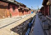
Figure 1 Conservation and restoration of relics
in renowned towns, Hadapu town, Tanchang county, Gansu province (the second batch, photographed by
Yuliang in 2020 )
|
certain
area, and a safeguarding force to protect the local economy and livelihood.
Since the unique treasure of towns make them famous and characteristic, the
renowned towns can see their value not only in the entity of historical scenic
spot, but the deposition of cultural consciousness much more. The remained
value of renowned towns, difficult to be measured by money, needs more prompt
scientific and reasonable conservation strategy and corresponding construction
approaches implemented. Under such a circumstance, a data-based approach is an
undoubtedly secure way to protect the value.
The spatial distribution
dataset of 312 renowned historical and cultural towns and scenic spots in China
is developed based on series of spatial distribution of traditional villages[1,2].
By virtue of this dataset, the affiliation between towns and superior
administrative branches can be clearly sorted out, and the location of towns
and scenic spots can be griped in space swiftly, which is conducive to the
promotion of renowned tows and conservation of outstanding cultures of the
towns (Figure 1).
2 Metadata of the Dataset
Detail information of the Spatial dataset of 312 historical and
cultural towns and scenic spots in China[3] is summarized in Table
1, which covers its full name, authors, geographic region, data of years,
dataset composition, data publisher and sharing service platform, data sharing
policies, etc.
Table 1 Metadata summary of the Spatial dataset of 312 historical and cultural
towns and scenic spots in China
|
Items
|
Description
|
|
Dataset
full name
|
Spatial dataset
of 312 historical and cultural towns and scenic spots in China
|
|
Dataset
short name
|
TownsScenicSpotsChina312
|
|
Authors
|
Yu, L.
F-8099-2018, School of Architecture, Soochow University, yuliang_163cn@163.cm
Qiu, Y. C. ABH-5207-2020, School of Architecture, Soochow University,
75284315@qq.com
Tang, M. J.
O-6467-2018, School of Architecture, Soochow University, 361988267@qq.com
Fu, M.
O-6455-2018, School of Architecture, Soochow University, 821064405@qq.com
Han, S.
AFS-0416-2022, School of Architecture, Soochow University, 2812209760@qq.com
Liu, Z. T. ABH-4639-2020, School of Architecture, Soochow University,
785025073@qq.com
|
|
Geographical
Region
|
China,covering 31
provincial administration regions (no data from Hong Kong, Macao and Taiwan)
|
|
Year
|
2003-2019 Data
format .shp, .kmz Data
size 1.48 MB
|
|
Data files
|
2 files
(Town&ViewSpot China312.kmz + Town&ViewSpot China312.rar)
|
|
Data
publisher
|
Global Change Research Data Publishing &
Repository, http://www.geodoi.ac.cn
|
|
Address
|
No.
11A, Datun Road, Chaoyang District, Beijing 100101, China
|
|
Data Sharing
Policies
|
Data from
the Global Change Research Data Publishing & Repository includes metadata, datasets
(in the Digital Journal of Global Change Data Repository), and
publications (in the Journal of Global Change Data & Discovery). Data sharing policy
includes: (1) Data are openly available and can be free downloaded via the
Internet; (2) End users are encouraged to use Data subject to
citation; (3) Users, who are by definition also value-added service
providers, are welcome to redistribute Data subject to written permission
from the GCdataPR Editorial Office and the issuance of a Data redistribution
license; and (4) If Data are used to compile new
datasets, the ??ten per cent principal?? should be followed such that Data
records utilized should not surpass 10% of the new dataset contents, while
sources should be clearly noted in suitable places in the new dataset[4]
|
|
Communication and searchable system
|
DOI,
CSTR, Crossref, DCI, CSCD, CNKI, SciEngine, WDS/ISC, GEOSS
|
3 Data Research and Development
The
published lists of renowned towns contain some information such as their names
rather than their spatial location. By identifying the names of renowned towns
and shapes of spatial objects, the spatial data of renowned towns can be
obtained. Then after extracting the location data of towns, the affiliation
between towns and superior branches can be drew, which would be included into
their respective data columns.
3.1 Data Sources
(1)
Concept of renowned towns: the historical and cultural villages and towns refer
to the towns and villages with abundant cultural relics and important
historical value or revolutionary significance. Back to 2003, the Announcement
of Renowned Historical and Cultural Towns and Villages in China published by
Ministry of Housing and Urban-Rural development and National Cultural Heritage
Administration raised the concept of renowned historical and cultural towns and
villages at the first time[5], namely, ??towns and villages selected
from the country, endowed with abundant cultural relics and important
historical value or revolutionary significance, which can reflect traditional
landscape and local national characteristics of some certain periods of
history, will be published in stages and in batches as the renowned Chinese
historical and cultural towns and villages??.
|
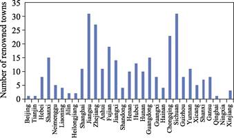
Figure 2 Renowned historical and cultural towns in China
|
(2) Data of
renowned towns: data shows that there are 312 renowned historical and cultural
towns in China, which covers 31 provincial administration regions without Hong
Kong, Macao and Taiwan. 10 renowned towns were released in the first batch in
October, 2003, and the seventh batch in January of 2019 disclosed 60 renowned
towns. Seven batches in 16 years saw a remarkable augment in quantity, in which
the seventh batch was 6 times more than the first batch with an average
increase of 71%. Yet different provinces held uneven distribution. In all
renowned towns released in seven batches, Jiangsu and Sichuan province had the
largest quantity, both reaching 31. And the two provinces accounted for 19.9%
of the total quantity, while Ningxia autonomous region had zero (Figure 2).
3.2 Data Processing
(1)
Data hypothesis: a renowned town is consisted of the town body and town area.
The body refers to the objects within the town, which can be further described
in terns of the status, shape, layout, etc. For town area, it defines the
spatial area for the development of objects and with physical traces moreover
that are convenient to be captured. That is the basis of researching and
developing the point data, namely, recognizing the trace of certain objects
within the appropriate space. The town stands as a part of administrative
system and occupies a certain area in space. As for town area, composed of
villages and markets of different scales (assuming the town has the market for
commodity circulation and residential area), is the targeted area in this
research, while the town body is mainly non-agricultural population.
(2) Data focuses:
boundary, scenic spot, impact point and scenic feature. The boundary means the
town area where objects develop. The scenic spot defines the area where objects
have the best development that is most worthy commemorating. The impact point
means it can easily follow and summarize the characteristic scenic feature by
tailing after the point, which stands as the feature spot of the major scenic
feature.
Since the point is
amorphous with small storage capacity, it can be utilized to summarize and mark
the signature surface feature in space and on the earth especially by
coordinating it with surface and solid. As the consequence, identifying the
scenic feature in scenic spot by image data, and then identifying the impact
point by point. This process substantially meets the demand of swiftly marking
the major scenic feature in scenic spot. The four focuses above are
interconnected with progressive relationship. The former is the fundamental and
condition of the latter, while the latter is the result of the former.
The scenic spot is
a gathering area for non-agricultural population, consisted of buildings,
roads, open spaces, rivers and green lands, etc. Among all the components,
buildings are the most conspicuous protuberance. Besides the vast horizontal
projection surface of the roof above the ground, buildings can be easily
recognized for their comparatively regular shadows, which makes a stark contrast
with mountains and plants. By virtue of the shape characteristics between
scenic features and other surface feature, the impact point can be effectively
utilized.
Due to the
inductive function of points in spatial data, there are numerous similar
researches on points. Bai[6] introduced the transformation from
point coordinate information to vector geospatial data based on Excel, while
Hao et al.[7] created the
geospatial distribution atlas of key protected wild plant species based on the
point fundamental data. Additionally, targeted as three published batches of
national traditional villages, Kang et al.[8]
made a distribution map of traditional villages in China on the basis of
location data of villages by Baidu API coordinate picker.
(3) Data path: as
the information source of town body obtained initially, the lists of renowned
towns is endowed with hierarchical relations of administrative affiliation. By
activating people??s daily memories, relations among place names, spatial
location and areas can be built, along with the information attached to texts
being interpreted into a comparatively comprehensive understanding of town
body. Researches and development on the information clues are conducive to the
location acquisition of town body and town area[9]. The data
processing of text is similar to coordinate acquisition of village spatial
points in the previous period[1,2].
|
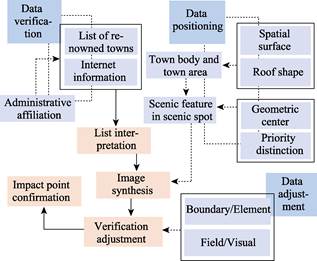
Figure 3 Acquisition
path of renowned towns?? spatial distribution
|
Data processing is the observation, analysis and adjustment of existing
material and status of space, which can be summarized into name organization
and spatial points and implemented in three steps. The first step is to verify
the data. Based on the lists of renowned towns, the list composition and text
characteristics can be analyzed and organized, especially for the town name and
administrative affiliation that need to be determined and corrected. The second
step is data positioning. Location of administrative government can be
confirmed preliminary, which then serves as a clue to identify the appropriate
location, scenic region and area of scenic spots. Later, more accurate location
and area of major scenic spot can be confirmed with scenic feature as the
target by using Google Earth. The last step is data adjustment for previous
point verification. This step is mainly depends on the field investigation and
virtual research on images. Differences need to be compared between surface
features?? characteristics shown on images and their entities in terms of
shapes, boundaries and features of new and old buildings. Simultaneously,
differences of remote areas?? image caused by the shooting angle can be adjusted
appropriately. So far, over ten years have witnessed authors conducting field
investigations on a quarter of 312 renowned towns. The acquisition path of
renowned town??s spatial point is demonstrated in Figure 3.
3.3 Organization of Town Name
The
point basis of renowned towns lays on the town name, the correct town name is
the first step of spatial point therefore. The preliminary review of lists
showed a case of vague name, namely, ??Youyang Tujia and Miao autonomous county,
Qianjiang district, Chongqing (the second batch)?? This case, lack of detailed
information, does not cover the town administration, After verification, the
correct name is ??Longtan town...??. The assessment of renowned towns underwent
dozens of years at a time when China was developing steadily and swiftly. The
adjustment of administrative division responds to the fast development in
institution, which is mainly reflected on names and administrative division.
According to Regulations on
Administration of Administrative Division, the major adjustments include
county upgraded to city, county (city) upgraded to district, district
combination, etc.[10] ,which shows a great feature of urbanization.
For instance, Yacheng town, Sanya, Hainan (town upgraded to city) and
Xin??ansuo town, Mengzi, Honghe Hani autonomous prefecture (county upgraded to city). Adjustments models below the
county-level contain village upgraded to town, village-town combination, etc.
Examples go as follows, Anchang town in Keqiao district, Shaoxing, Zhejiang
province now is converted to Anchang community. Co-existence of multiple
administrative divisions is conducive to the development of urbanization in
different cities across China, and comprehensive regional development in terms
of economy, politics, society and culture additionally. There are 16 renowned
towns upgraded in the first list review, accounting for about 5% of the total
(Table 2).
Table 2 Summary
of administrative division adjustment
|
Region
|
Adjustment model
|
No.
|
Town name
|
Batch
|
Original division
|
Current division
|
Number
|
|
Urban
|
Town upgraded to city
|
69
|
Yacheng town
|
3
|
Yacheng town
|
Yazhou district
|
1
|
|
County upgraded to district
|
113
|
Zhuxian town
|
4
|
Kaifeng county
|
Xiangfu district, Kaifeng
|
4
|
|
119
|
Jinggang town
|
4
|
Wangcheng county
|
Wangcheng district
|
|
236
|
Wenquan town
|
6
|
Kai county
|
Kaizhou district
|
|
243
|
Hengjiang town
|
6
|
Yibin county
|
Yibin district
|
|
County upgraded to city
|
178
|
Xin??ansuo town
|
5
|
Mengzi county
|
Mengzi
|
3
|
|
244
|
Yunding town
|
6
|
Longchang county
|
Longchang
|
|
247
|
Gaojiapu town
|
6
|
Shenmu county
|
Shenmu
|
|
Town
|
Village-town combination
|
153
|
Dangkou town
|
5
|
Dangkou town
|
Ehu town
|
1
|
|
Town converted to community
|
20
|
Anchang town
|
2
|
Anchang town
|
Anchang community
|
7
|
|
50
|
Chunxi town
|
3
|
Chunxi town
|
Chunxi community
|
|
53
|
Dongpu town
|
3
|
Dongpu town
|
Dongpu community
|
|
98
|
Jiading town
|
4
|
Jiading town
|
Jiadingzhen community
|
|
131
|
Enyang town
|
4
|
Enyang town
|
Dengke community
|
|
157
|
Hexi town
|
5
|
Hexi town
|
Hexi community
|
|
201
|
Xiping town
|
6
|
Xiping town
|
Xiping community
|
|
In total
|
16
|
The second aspect
is text phonetic notation. VLOOKUP Function in Excel was used in the complete
lists to check and match the attribute columns such as ??ProvinceCN??, ??CityCN??,
??DistrictCN??, etc. Then the administrative hierarchy was corresponded to the
respective name. As for Chinese phonetic notation, shortcut plugins of Excel
such as ??Pinyin Conversion?? and ??Capitalization?? were used to conduct process and
review. Other approaches such as water system within and outside the town,
traffic direction and organization methods of other elements have also been
used to better conduct positioning, enhance the relations between names and
location points, and gradually decrease the administrative hierarchy to
approach the positioning area. Taking Taiping town, Gulin county, Luzhou,
Sichuan province and Luzhou, Sichan province as an example, both of them are
easy to locate with obvious town area. It is difficult to distinguish the
location of scenic spot, however. Maps show that the scenic spot is near to the
corner of Gulin river. By virtue of river??s direction, the location of scenic
spot can be finally confirmed. Besides, the town name itself contains some
meanings related to water, wharf and historical events, which can verify the
status quo of military campaigns and revolutionary historical areas (Table 3).
The number of the last attribute table of renowned towns is ranked according to
the publish order of the lists. Different administrative affiliations are
included in respective columns of the table, demonstrating four administrative
hierarchies.
3.4 Positioning of Town
From
town to county, city and then to province, there are four administrative
hierarchies in total. After finishing the preliminary positioning in Baidu Map
on the basis of information from the lists, Google Earth is used to obtain the
spatial point. Identification of spatial shape characteristics of town body and
town objects is conducted then, while stress is put on the hierarchy
differences. In administrative hierarchy, the town is one level higher than
village being extracted previously. Despite that both town and village
highlight the lives of people, they do have differences in essence. A town is
usually endowed with scenes of people??s lives as well as markets for
transactions, which demonstrates that the space of renowned towns is rich in
types and ranges.
Table 3 Meanings
and characteristics of typical town names
|
No.
|
Meanings of town name
|
Feature words
|
|
1
|
??Water; ??Wharf (or transportation
hub); ??Agricultural products, industrial craftsmanship
|
????Tang, Tan, Jiang, Tuo, Quan, Xi, Wan, He, Gou, Luo, Jing, Tan, Hu,
Ze, Du, Shui, Zhu??
????Gang, Hekou, Yiqian??
????Yetao, Yanguan, Futian, Zhoutie, Bencha??
|
|
2
|
Divisions where ethnic minorities live
|
Xinbin Man autonomous county, Jiuyang Tujia and Miao autonomous
county, Harqin Banner, Yehe, Wulajie town, Songtao Miao autonomous county,
Guangxi Zhuang autonomous region, Jingning She autonomous region, Xunhua Sala
autonomous region
|
|
3
|
Significant historical event, combat and revolutionary historical area
|
Gutian, Zhoulaozui, Qiliping, Niangziguan, Shajiabang, Tingsiqiao
|
|
4
|
Quite familiar with
|
Maotanchang, Xinghuacun town, Dawenkou town
|
|
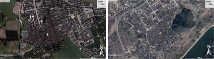
Figure 4 Conspicuous
difference between town areas
(Left:
Zhouzhuang town, Kunshan, Jiangsu; Right: Qiantong town, Ninghai county,
Ningbo, Zhejian)
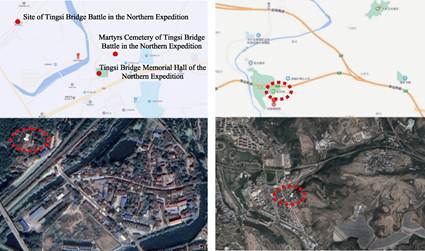
Figure 5 Less
conspicuous difference between town areas (Left: Tingsiqiao town, Xianning,
Hubei province (the fourth batch); Right: Runcheng town, Tangcheng county,
Jincheng, Jiangxi province (the fifth batch))
|
To maintain its
normal operation, the town is equipped with numerous and multiple kinds of
surface feature facilities, which makes a stark contrast with village that is
lack of richness in image, graph and scale. Adequate historical and cultural
buildings of small volume can be seen in scenic spots of towns with regular
shapes and comparatively darker roof in orthographic projection. It makes it
much easier to distinguish and then locate the scenic spots and scenic features
thanks to the sharp contrast between those buildings and other surface features
in terms of location, shapes and sizes. Consequently, the analysis of
combination and protection status between renowned towns and building entity
space can be conducted. As for town body and town area, while some certain
scales and information can be obtained from related department[11],
information does not cover the scenic spots, which stands as the main reason
why data of scenic feature need to be acquired in images.
To conduct analysis
on positioning operation, it needs make the judgment BMY the regularity of the
whole image based on the priority of scenic spots and scenic features as well
as their corresponding location. To make is more easy and convenient for
marking points, two principles are adopted in positioning. The first is
targeted at the regular-shaped scenic spots within the town area, which is
obviously different with surrounding scenery. Under such circumstance, the
point in on the geometric center of the entire scenic spot. As demonstrated in
Figure 4, Zhouzhuang town, Kunshan, Jiangsu province and Qiantong town, Ninghai
county, Ningbo, Zhejiang province.
The second
principle can be applied to those scenic spots that are difficult to
distinguish. They usually have numerous types of buildings, novel roofs, and
different combinations of scenic spots and scenic features in small scale
which form the landscape with conspicuous order. Positioning means selecting the
important scenic features as the scenic spots being positioned, namely, the
significant scenic features famous for their profound history and culture and
other unique backgrounds. To choose those satisfactory scenic features,
assessment by institutions at different level (such as national titles,
cultural relics under protection)[12–14], research and analysis on
materials and social reputation can be served as the reference[15,16].
On the left of Figure 5 is Tingsiqiao town, Xianning, Hubei province with
several scenic features. Among all of them, the site of Tingsi Bridge Battle in
the Northern Expedition, a key cultural relic under protection, is of the most
significance, explaining why the positioning point lies here. On the right of
Figure 5 is Runcheng town, Jincheng, Jiangxi province with multiple scenic
features such as Tianguang Palace and Dongyue Temple, yet Diji city stands as
the positioning point since it is the key cultural relic
under
national protection released in the sixth batch.
Table 4
demonstrates there are three models of boundaries of different positioning
points,namely, conspicuous, inconspicuous and mediocre with respective quantity
of 235, 63 and 14, accounting for 75.3%, 20.2% and 4.5%. The model of
inconspicuous has the largest proportion and the proportion of mediocre-model
is less. As for the positioning points of scenic spots, the positioning
quantities of geometric center and priority scenic spots are 233 and 79
respectively, accounting for 74.7% and 25.3%. Results above show that
positioning type of conspicuous boundaries makes up a majority.
Table 4 Quantity
of renowned towns and their proportion under different positioning principles
|
Positioning perspective
|
No.
|
Characteristics of object
|
Quantity of renowned towns
|
Proportion (%)
|
|
Boundary
|
1
|
Conspicuous
|
235
|
75.3
|
|
2
|
Inconspicuous
|
63
|
20.2
|
|
3
|
Mediocre
|
14
|
4.5
|
|
Total
|
312
|
100
|
|
Scenic Feature
|
1
|
Geometric Center
|
233
|
74.7
|
|
2
|
Priority Scenic
Feature
|
79
|
25.3
|
|
Total
|
312
|
100
|
4 Data Results
4.1 Composition of Dataset
The
dataset is composed of two subsets, namely, a version of ArcGIS .shp and a
version of Google .kmz of the Spatial distribution dataset of 312 renowned
historical and cultural towns and scenic spots in China (the names are
Town&ViewSpot China312.kmz and Town&ViewSpot China312.rar
respectively). There are 16 data files with the size of 1.48 MB, which is
compressed to 2 files with the sized of 113 KB. The subsets consist of two sets
of point data marked as the location of towns and scenic spots. These two sets
are different from each other while also share common relations, and they can
be linked by the form of library and served as source sheet and target sheet.
Through Data.mdb, the sets of data can be summarized.
4.2 Data Result
Data
of renowned towns cover 31 provinces, cities and autonomous regions. The
distribution of points shows an uneven pattern of integration or dispersion in
space. Most of the renowned towns are in the southeast, especially in the
Yangtze River Delta region with 80 renowned towns. The second-densest area is
Sichuan Basin, mainly the plains and hills in the southeastern Sichuan and
hills in southwestern Chongqing. Many of renowned towns are also located in the
junction of Shanxi, Hebei and Henan, central Hubei, southern Anhui, Zhejiang,
Fujian, and eastern Jiangxi. As for Xinjiang in the northwest and Heilongjiang
in the northeast, they both has the least renowned towns.
Moreover, the
renowned town do have eight kinds of historical values and features including
culture, economy and trade, revolutionary history, military affairs, etc, which
in fact coexists rather than exists alone. Based on the principle of relational
similarity, the eight kinds of historical values and features are summarized to
five kinds in this research. In 312 renowned towns, 275 belong to cultural
class, 80 belong to commercial and transportation class, 59 are building ruins
and national characteristics, and 17 are ecological and environment protection
class. The classification above is a brief summary of data. As a matter of
fact, further researches can be conducted on spatial distribution feature of
renowned towns based on the spatial point data. It can be firmly believed that
researches and application of the data go beyond far more than that.
Author Contributions
Yu, L. made an overall design for the
acquisition and development of datasets, and wrote data thesis; Qiu, Y. C. and
Tang, M. J. organized and verified the key data; Han., S., Fu, M., and Liu, Z.
T. conducted the processing of data locating.
Conflicts of Interest
The
authors declare no conflicts of interest.
References
[1]
Yu,
L., Liu, J., Ding, Y. Q., et al. The
spatial distribution dataset of 2555 Chinese traditional villages [DB/OL].
Global Change Data Repository, 2018. https://doi.org/10.3974/geodb.2018.04.06.V1.
https://cstr.escience.org.cn/CSTR:20146.11.2018.04.06.V1.
[2]
Yu,
L., Tang, M. J., Fu, M., et al.
Spatial distribution dataset of 2666 more traditional villages in China
[J/DB/OL]. Digital Journal of Global Change Data Repository, 2020.
https://doi.org/10.3974/geodb. 2020.03.22.V1.
https://cstr.escience.org.cn/CSTR:20146.11. 2020.03.22.V1.
[3]
Yu,
L., Qiu, Y. C., Tang, M. J., et al.
Spatial Dataset of 312 Historical and Cultural Towns and Scenic Spots in China
[J/DB/OL]. Digital Journal of Global
Change Data Repository, 2022.https://doi.org/10.3974/geodb.2022.03.04.V1.
https://cstr.escience.org.cn/CSTR:20146.11.2022.03.04.V1.
[4]
GCdata PR Editorial Office.
GCdataPR data sharing policy [OL]. https://10.3974/dp.policy.2014.05
(Updated in 2017).
[5]
Ministry of Housing and
Urban-Rural Development of the People??s Republic of China. Notice on the
Announcement of Renowned Historical and Cultural Towns (Villages) in China (the
First Batch) [EB/OL]. (2003-12-01)[2022-04-02].
https://www.mohurd.gov.cn/gongkai/fdzdgknr/tzgg/200312/20031201157345.html.
[6]
Bai, T. T. Research on an
excel-based geospatial data acquisition method [J]. Journal of Green Science and Technology, 2018(18): 182–183.
[7]
Hao, T., Wang, X., Liu, Y., et al. A list of key protected wild
plants and their spatial location distribution mapping in Hubei [J]. Hubei Forestry Science and Technology,
2018, 47(6): 1–5, 52.
[8]
Kang, J. Y., Zhang, J. H., Hu,
H., et al. Analysis on the spatial
distribution characteristics of Chinese Traditional Villages [J]. Progress in Geography, 2016, 35(7):
839–850.
[9]
Zhou, C., Sun, D. D. Analysis
on the application of remote sensing mapping in cartography [J]. Technology Innovation and Application,
2020(3): 171–172.
[10]
Wei, H., Wei Q. Q., Cao, T. Y.,
et al. Types, problems and changes
for readjustment of administrative division in the process of urbanization [J].
Human Geography, 2009, 24(6): 55–58.
[11]
Ministry of Civil Affairs of
the People??s Republic of China. The Brochure of Administration Division of
Township in P. R. China 2018 [M]. Beijing: China Society Press, 2018.
[12]
Ministry of Housing and
Urban-Rural Development of the People??s Republic of China [Z]. https://www. mohurd.gov.cn/.
[13]
National Cultural Heritage
Administration. http://www.ncha.gov.cn/col/col2266/index.html.
[14]
Jiangsu Government Affairs
Network. http://kszzz.jszwfw.gov.cn/.
[15]
Xinhua Net.
http://www.xinhuanet.com/travel/2018-06/22/c_1123022492.htm.
[16]
Guying Town.
http://newpaper.dahe.cn/hnrb/html/2016-11/21/content_95369.htm.