Coastline and City Location Dataset of Sri Lanka
Liu, C.* Shi, R. X. Zhu, Y. Q
Institute of Geographic Sciences and Natural Resources Research, Chinese Academy of Sciences, Beijing 100101, China
Keywords: Sri Lanka; coastline; island; cities; data encyclopedia item
|
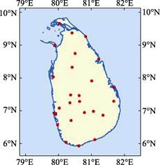
Figure 1 Coastline and city location dataset
of Sri Lanka
|
Sri Lanka is consisted of Sri Lanka Island and several small islands around it. The maximum long is 435 km from north (9°50′40″N) to south (5°55′08″N) and its maximum width is 226 km from east (81°52′47″E) to west (79°27′05″E) (Figure 1). Sri Lanka faces the southeast of the Indian subcontinent crossing the Palk Strait and the Gulf of Mannar in the west and Maldives in the southwest. Besides the Sri Lanka Island, the Mannar Island, Jaffna Island, Delft Island, Punkudutivu Island, Nainativu Island, Analaitivu Island, Mandaitivu Island and Karainagar Island are included. It has an area of 65,817.24 km2, in which, the area of the Sri Lanka Island is 65,437.10 km2. The total length of the coast lines is 4,349.68 km based on the Google Earth Images in 2015, in which the coastline of the Sri Lanka Island is 3,455.31 km. The coastline of Sri Lanka is less curvature, except a series of lakes. The capital of Sri Lanka is Sri Jayawardenepura Kotte, which is located at southern part of the city of Colombo, the commercial capital of the country. 9 provinces and 25 districts have been divided in the administrative system under the center government. The provinces are: Central Province, North Central Province, Eastern Province, North-Western Province, Sabaragamuwa Province, Southern Province, Uva Province, Western Province and Northern Province. The districts are: Colombo, Kandy, Nuwara Eliya, Hambantota, Anuradhapura, Galle, Polonaruwa, Kurunegala, Trincomalee, Jaffna, Matara, Badulla, Kalutara, Moneragala, Ampara, Matale, Batticaloa, Killinochchi, Vavuniya, Mulativu, Mannar, Puttalam, Gampaha, Kegalle, Ratnapura. The data is archived in both .kmz and .shp formats with the compressed data size of 14.79 MB.