Description to the Historical Records Dataset on Human
Activity in the Hexi Corridor of China (from Neolithic to Qing Dynasty)
Gao, M. J.2
Li, Y.1,2*
1 Key
Laboratory of Western China??s Environmental Systems (Ministry of Education),
Lanzhou 730000, China;
2 College
of Earth and Environmental Sciences, Lanzhou University, Lanzhou 730000, China
Abstract: Social responses to
environmental change over human history have generated extensive debate among
researchers. Comprehensive human activity databases are valuable for exploring
the links between human evolution and environmental change. The Hexi Corridor
is a crucial area where eastern and western civilizations met due to its
location in the eastern section of the ancient Silk Road. Here, we present a
comprehensive dataset of the Hexi Corridor, including disasters, population,
wars, famines, and settlements from the Neolithic to the Qing dynasty. These data are mainly from various digitized
historical sources, which have been extracted, digitized, and georeferenced
through a standardized process. The ultimate aim of these data is to provide as
comprehensive a record as possible of human activity in the Hexi Corridor to
support ongoing research on human-environment relations.
Keywords: Hexi Corridor; human activities;
disasters; ancient sites
DOI: https://doi.org/10.3974/geodp.2023.02.08
CSTR: https://cstr.escience.org.cn/CSTR:20146.14.2023.02.08
Dataset Availability Statement:
The dataset supporting this paper was published and is accessible through
the Digital Journal of Global Change
Data Repository at: https://doi.org/10.3974/geodb.2023.07.09.V1
or https://cstr.escience.org.cn/CSTR:20146.11.2023.07.09.V1.
1 Introduction
It
is undoubtedly a serious challenge to modern societies?? political and economic
development rate than ever before[1, 2]. Over the past tens of
thousands of years, human has gone from being dependent on nature to using
nature try to try to develop in harmony with nature, culminating in the present
civilization[3, 4]. Over the past century, research on environmental
change has been mainly concerned with the natural sciences[5, 6]. As
research continues, scientists are finding it increasingly impossible to ignore
the impact of human activity. Using human activity as a thread provides a new
perspective on the relationship between environmental change and human activity
in the research on the relationship between human origins, agricultural
origins, civilizational origins, social development, and climatic and
environmental changes[7?C10]. These research directions have been
implemented and advanced with increasing emphasis on the impact of human
society on global environmental change and the issue of human society??s
response and adaptation to global change. The volume of this work and its
evolving scientific understanding generate organizational challenges associated
with data collection, extraction, validation, and application.
The spatial and
temporal integration of human data involves the spatial differentiation of
complex human activities, and many theoretical and technical problems need to
be overcome, including the spatial distribution of human data, theoretical and
methodological research related to data sampling, and results testing[11].
Compared with natural environmental data, human data are mainly based on human
units rather than natural units in terms of spatial units. This poses problems,
such as difficulty identifying dates, low spatial resolution, differences in
dating methods, and changes in administrative boundaries[12].
The Hexi Corridor
is a typical area of synergistic influence of the mid-latitude westerly
circulation and the Asian monsoon and is a sensitive area for environmental
change[13]. It is located at the throat of the Silk Road. It is an
important route for the spread of prehistoric humanity and cultural exchanges
between East and West, as well as a meeting point for the evolution of
civilizations in Eurasia and a frontier for the clash between Chinese
agricultural and nomadic civilizations[14,15]. Finally, considering
that the Hexi Corridor is the main oasis agricultural and landscape
distribution area in China and worldwide, with significant changes in water
resources and fragile oasis ecosystems, together with the currently hotly
debated warming and humidification of the Northwest and climate hazards, the
region is an area of concern for future climate change[16].
Here, we present a
new database of Holocene paleoclimate human and historical records from the
Hexi Corridor and the adjacent region. This database is composed of records
from individual sample studies and records that are compiled by previous
summaries. This database includes disasters, population, wars, famines, and
settlement records that reflect human activities. All data is published in .xlsx
format. This geographically distributed collection of human activity data
records integrates environmental change as well as human activity
characteristics in the Hexi Corridor region, forming a network from which to
assess the spatial and temporal variability of regional climate change and
human activity.
2 Metadata of
the Dataset
The metadata of the Historical records dataset on
human activity in the Hexi Corridor of China (from Neolithic to Qing dynasty)
is summarized in Table 1[17].
3 Methods
3.1 Data Collection and
Data Extraction
Human activity data are considered for
inclusion in the regional environmental change database. Human history data is
obtained from a wide range of historical sources in China, including various
historical sources such as general histories, ancient maps, annals, and modern
secondary statistics such as government releases, books, modern maps, and some
recent research papers. This dataset is intended to extract data on the
humanities of Gansu province from the Neolithic period to the Qing dynasty, including
ancient sites, ancient cities, disasters, wars, population, and famine. The
processing of the primary data is broken down into the following categories.
(1) War
This
chronology is based on the chronology of the wars that took place in China from
the legendary Shennong era in the 30th century BC to the end of the Qing
dynasty in 1911 and provides a brief account of the causes, course, outcome,
and characteristics of the significant
Table
1 Metadata summary of the digital database of human
activity in the Hexi Corridor[17]
|
Items
|
Description
|
|
Dataset full name
|
Historical
records dataset on human activity in the Hexi Corridor of China (from
Neolithic to Qing dynasty)
|
|
Dataset short
name
|
HexiCorridorHumanActivity
|
|
Authors
|
Gao, M. J.
HTR-7743-2023, College of Earth and Environmental Sciences, Center for
Hydrologic Cycle and Water Resources in Arid Region, Lanzhou University gaomj21@lzu.edu.cn
Li, Y., Key
Laboratory of Western China??s Environmental Systems (Ministry of Education); College of Earth
and Environmental Sciences, Center for Hydrologic Cycle and Water Resources
in Arid Region, Lanzhou University, liyu@lzu.edu.cn
|
|
Geographical
region
|
the Hexi Corridor
|
|
Year
|
4000 BC?C1900 CE
|
|
Spatial
resolution
|
City and county
|
|
Data format
|
.xlsx, .shp
|
|
|
|
Data size
|
1.78 MB
|
|
|
|
Data files
|
3 datasheets:
ancient city and ancient ruins (including .shp), disaster and famine; wars
|
|
Foundations
|
National Natural
Science Foundation of China (42077415); Ministry of Science and Technology of
P. R. China (2019QZKK0202, BP0618001)
|
|
Data publisher
|
Global Change Research Data Publishing & Repository,
http://www.geodoi.ac.cn
|
|
Address
|
No. 11A, Datun
Road, Chaoyang District, Beijing 100101, China
|
|
Data sharing
policy
|
Data from the Global Change Research Data
Publishing & Repository includes metadata, datasets (in the Digital Journal of Global
Change Data Repository), and publications (in the Journal of Global
Change Data & Discovery).
Data sharing
policy includes: (1) Data are openly available and can
be free downloaded via the Internet; (2) End users are encouraged to use Data
subject to citation; (3) Users, who are by definition also value-added
service providers, are welcome to redistribute Data subject to written
permission from the GCdataPR Editorial Office and the issuance of a Data
redistribution license; and (4) If Data are used to compile new
datasets, the ??ten per cent principal?? should be followed such that Data
records utilized should not surpass 10% of the new dataset contents, while
sources should be clearly noted in suitable places in the new dataset[18]
|
|
Communication and
searchable system
|
DOI, CSTR, Crossref, DCI, CSCD, CNKI, SciEngine, WDS/ISC, GEOSS
|
wars[19]. Due to the subjective nature of the records, we have not
compiled statistics on the number of casualties of the wars but merely
extracted the time, place, and type of warfare. For the time of the war, the
imperial chronology was converted into the A.D. chronology by comparing it with
the ancient Chinese chronology. For the location of the war, it has been converted
into a modern location according to Chinese Historical Atlas[20]. We
examined the causes of the wars and divided them into rebellious wars and other
wars[20].
(2) Disaster and famine
The main source of disaster information is the History of Disasters in Northwest China,
a systematic summary of the history of disasters in the Northwest of China
based on hundreds of credible historical documents[21]. and we have
also collected documents published in journals and searched the original
records to check them all and fill in the gaps to reflect the historical
climate more objectively[22?C25]. As historical sources are sometimes
lost after being collated several times, we still consider them reliable but do
not mark them as such.
(3) Population
As in modern societies, population counts are not
conducted annually, and often, feudal rulers would only conduct a census once
during their reign, so the population numbers obtained through historical
sources often vary in time intervals. In order to provide a more comprehensive
picture of the demographic trends in the Hexi Corridor, we have collected the
current continuous demographic studies and, using mathematical methods based on
previous studies, have calculated the population numbers at 50-year intervals[26?C28].
(4) Ancient sites and an cities
The ancient sites and cities??
statistics are based on the Atlas of
Chinese Cultural Relics-Fascicule of Gansu province. The coordinates are
given using the spatial alignment function of ArcGIS to obtain the coordinates
of the spatial location of the protected units and export them to Excel. The
coordinates of the ancient cities are calibrated with the help of Google Maps.
The chronology of the ancient city is calibrated according to the descriptions
in the atlas and combined with archaeological data.
Other human and paleoclimatic records are considered
but ultimately excluded because they did not meet the selection criteria. Most
of the excluded records are either not sufficiently clear in their description
of human activity, e.g., lacking information on elements such as time and place
not credible sources; some wild histories and documents processed several times
lack a clear relationship between proxies and climate, of insufficient duration
or poor regional representation, and not meeting the sampling resolution
criteria.
3.2 Technical Workflow
The reconstruction process of
human activity data mainly included (1) Extracting different types of
anthropogenic data from historical sources, and (2) Generating tables and
drawing diagrams of anthropogenic data. Figure 1 shows the workflow for
extracting different types of human activity data.
4 Data Results
and Analysis
Figure 2 shows the
statistical curves for changes in disasters and famines. We collect and collate
data on 1,085 disasters and information on 238 famines. Droughts and floods are
the main types of disasters in the Hexi Corridor, with the sum of the two
accounting for almost half of the disasters in the Hexi Corridor (Figure 2b). In terms of rank, mild and moderate disasters make up the
majority (Figure 2a). Based on spatial data, the
distribution of disasters in the Hexi Corridor is relatively even, with no
prominent most challenging hit areas (Figure 2c). The Ming and
Qing dynasties (1368 AD-1912 CE) appear to
have been a period of high disaster occurrence, as indicated by the curve of
disasters over time, but this may be because more historical material has
survived from that period (Figure 2d).
Figure 3 shows the
distribution of ancient sites and cities from the Neolithic period to the Qing
dynasty. Of the 2,077 site points information collected and collated, there are
2005 ancient site points and 72 ancient burial sites. According to the spatial
distribution characteristics, in the early Neolithic period, the site points of
the Majiayao culture were mainly distributed in the eastern part of the
corridor. In contrast, the Qijia culture continued to expand to the east and is
more concentrated (Figure 3ab). The Qijia culture is followed by a period of
richness in ancient cultural types in the Hexi Corridor, and these cultures
begin to migrate to the western part of the corridor. The early sites are
distributed on the highlands according to the DEM features. However, as the
culture developed and the distribution of sites diversified, they also began to
move downstream towards the rivers, seemingly due to increased topographic
adaptation (Figure 3c). The reasons for this phenomenon may be multifaceted and are a matter for further research.
The ancient cities of the Hexi Corridor have been built and abandoned many
times throughout the historical period (Figure 3d). The Silk Road is the
central vein of distribution of the ancient cities, and almost all of them were
built along the Silk Road. During the Qin-North and South dynasties, the
distribution of ancient cities was loose, basically scattered along the
Han Great Wall. From the Song-Yuan period onwards, the focus of the
distribution of ancient cities began to be within the Ming Great Wall, and most
of them fell into disuse. The Ming and Qing dynasties are the period with the
largest number of ancient cities in the Western Corridor, possibly due to the
development of the rulers and the short period that has passed since then,
making them easy to preserve.
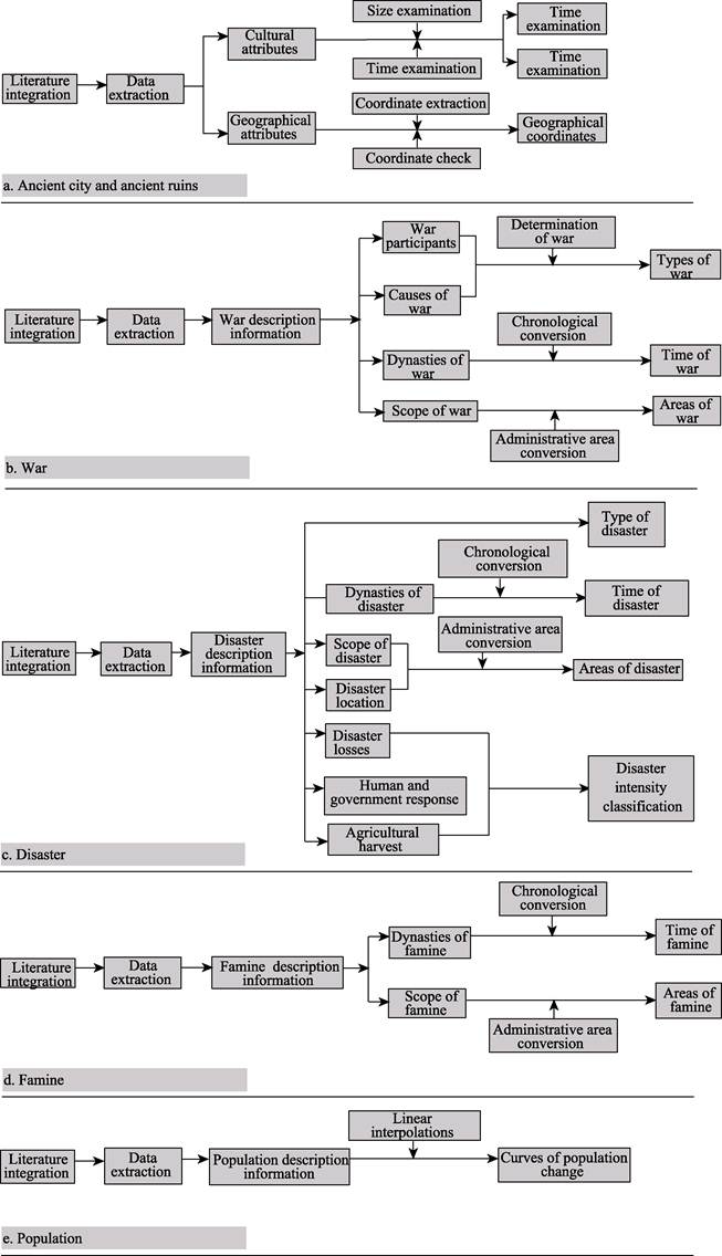
Figure 1 Workflow for extracting
different types of human activity data
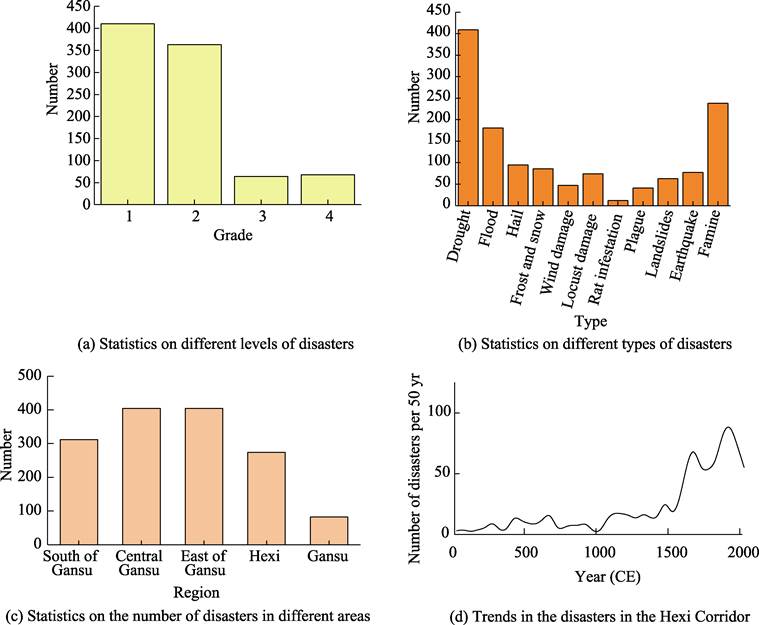
Figure 2 Statistics of disasters and
famines in the Hexi Corridor.
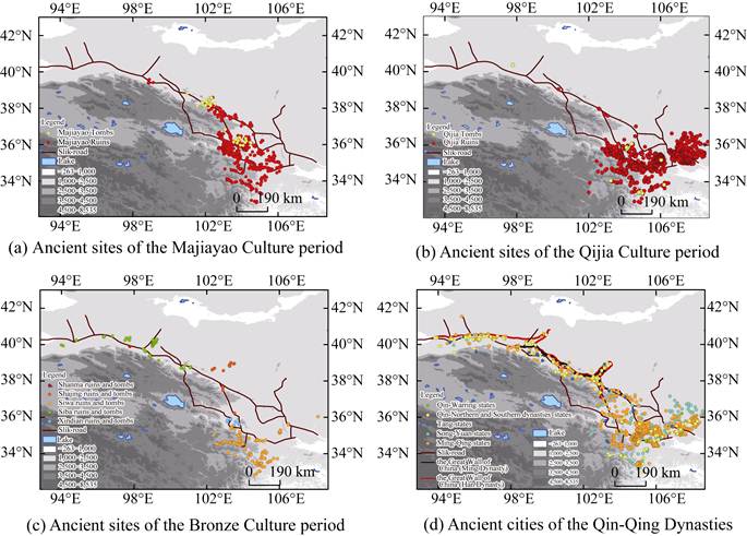
Figure 3 Maps of data on ancient
sites and ancient cities in the Hexi Corridor
Figure 4 Maps of data on wars in the Hexi Corridor
Central Gansu and South of Gansu are hot
areas of warfare, with few wars spreading throughout Gansu (Figure 4a).
Rebel wars account for only about a tenth of the total number of wars (Figure 4b).
The peak of warfare occurred before 500 CE, after which the population of the
Hexi Corridor reaches its lowest value (Figure 4c,
Figure 5). Many
studies have analyzed the interaction between disaster, famine, war, and
population. Although the curves show consistent or opposite trends, it seems
that this alone is not entirely appropriate. By tracing a specific disaster
event through time and space, we do not find social severe consequences, and
the relationship between extreme events and social unrest remains uncertain.
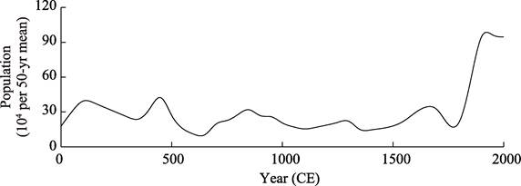
Figure 5 Trends in the population in the Hexi
Corridor
5 Data Validation
5.1 Quality Control
The collection and extraction
of a digital database of human activity is produced with strict quality control
throughout the procedures. The location of ancient sites and cities is examined
via professional GIS tools (ArcGIS) to ensure the accuracy of their geographic
locations. For wars, disasters, and famines, it is necessary to
match the time and place of occurrence, mainly due to differences in
chronological methods and changes in administrative areas.
5.2 Uncertainties
This study aims to collect
evidence of typical human activities in the Hexi Corridor region. Due to the
complexity of the current sources of human activity data, the following
spatiotemporal mismatches are common, i.e., the periods do not fully coincide,
or the spatial extent does not fully overlap. This is inconvenient for
correcting information from multiple sources and impacts the analysis of
regional patterns. Although we have improved the accuracy of the data through
integration and intercomparison, there is still uncertainty in the description
of regional human activity patterns. For this reason, more efforts are needed
to generate a more accurate database. On the one hand, deeper information
mining on the Hexi Corridor is needed. In the future, we consider collecting
human economic data, such as the extent of arable land and metal production, to
analyze better the relationship between people and the environment in the
region. On the other hand, machine learning will establish a standardized data
extraction process to extract information on human activities in the data more
accurately.
6
Conclusion
Through the collection and
processing of research data related to the historical geography of the Hexi
Corridor (e.g., research papers, books, scientific research reports, etc.), the
database of human activities in the Hexi Corridor was obtained, which is a
secondary development study based on the primary data. In producing the data,
making human judgments on each is necessary, and the production process takes a
long time. The human activity database of the Hexi Corridor obtained by this
method has good accuracy in analyzing the spatial distribution, disaster
evolution, and population change of the whole Hexi site in a long time range.
However, it is less accurate for smaller fields such as counties and townships,
which is mainly limited by the ambiguity of the data source records and the
uncertainty of the administrative range in the historical period. Also, due to
the diversity of data, there are cases of conflict with the original data,
which also results in a decrease of the accuracy of the data.
As an important part of
the Silk Road, the Hexi Corridor has been an essential passage for traders and
the military for nearly a thousand years. Taking the Hexi Corridor as an
example, this database completes a data architecture of human-land relations in
a small region, which can be used to analyze the long-term evolution of human
activities in the context of climate change in a targeted manner and can be
used as a template for other regions seeking to understand their
human-environmental history better.
Author contributions
Li, Y. designed the research; Gao, M.J
implemented the research and analyzed the results.
Conflicts of Interest
The authors
declare no conflicts of interest.
References
[1]
Burke,
A., Peros, M. C., Wren, C. D., et al.
The archaeology of climate change: the case for cultural diversity [J]. Proceedings of the National Academy of
Sciences, 2021, 118(30): e2108537118.
[2]
Doblas-Reyes,
F. J., Srensson, A. A., Almazroui, M., et
al. IPCC AR6 WGI Chapter 10: Linking Global to Regional Climate Change [M].
Cambridge: Cambridge University Press, 2021.
[3]
Gornitz,
V. Encyclopedia of Paleoclimatology and Ancient Environments: Encyclopedia of
Earth Sciences Series [M], Dordrecht: Springer, 2009.
[4]
Lv,
H. Y. Periodic climate change and human adaptation [J]. Acta Anthropologica Sinica, 2022(4): 41.
[5]
Valero-Garc??s,
B. L., Moreno, A. Iberian lacustrine sediment records: responses to past and
recent global changes in the Mediterranean region [J]. Journal of Paleolimnology, 2011, 46: 319?C325.
[6]
Chen,
F. H., Chen, J. H., Huang, W., et al.
Westerlies Asia and monsoonal Asia: Spatiotemporal differences in climate
change and possible mechanisms on decadal to sub-orbital timescales [J]. Earth-science Reviews, 2019, 192:
337?C354.
[7]
Weiss,
H., Courty, M. A., Wetterstrom, W., et al.
The genesis and collapse of third millennium north Mesopotamian civilization
[J]. Science, 1993, 261(5124):
995?C1004.
[8]
Sarkar,
A., Mukherjee, A. D., Bera, M. K., et al.
Oxygen isotope in archaeological bioapatites from India: Implications to
climate change and decline of Bronze Age Harappan civilization [J]. Scientific Reports, 2016, 6(1): 26555.
[9]
Degroot,
D., Anchukaitis, K., Bauch, M., et al.
Towards a rigorous understanding of societal responses to climate change [J]. Nature, 2021, 591(7851): 539?C550.
[10]
Berrang-Ford,
L., Siders, A. R., Lesnikowski, A., et al.
A systematic global stocktake of evidence on human adaptation to climate change
[J]. Nature Climate Change, 2021,
11(11): 989?C1000.
[11]
Shi,
P., Wang, J., Yang, M., et al.
Understanding of natural disaster database design and compilation of digital
atlas of natural disasters in China [J]. Geographic
Information Sciences, 2000, 6(2): 153?C158.
[12]
Zheng,
J. Y., Hao, Z. X., Di, X. C. A study on the establishment and application of
environmental change database during historical times [J]. Geographical Research, 2002, 21(2): 146?C154.
[13]
Li,
Y., Wang, N. A., Li, Z, L., et al.
Comprehensive analysis of lake sediments in Yanchi Lake of Hexi Corridor since
the late glacial [J]. Acta Geographica
Sinica, 2013, 68(7): 933?C944.
[14]
Barisitz,
S. Central Asia and the Silk Road: Economic Rise and Decline over Several
Millennia [M]. Springer International Publishing, 2017.
[15]
Dong,
G. H., Yang, Y. S., Liu, X. Y., et al.
Prehistoric trans-continental cultural exchange in the Hexi Corridor, northwest
China [J]. The Holocene, 2018, 28(4):
621?C628.
[16]
Li,
X., Gou, X. H., Wang N. L., et al.
Tightening ecological management facilitates green development in the Qilian
Mountains [J]. Chinese Science Bulletin,
2019, 64(27): 2928?C2937.
[17]
Gao,
M. J., Li, Y. Historical records dataset on human activity in the Hexi Corridor
of China (from Neolithic to Qing dynasty) [J/DB/OL]. Digital Journal of Global Change Data Repository, 2023.
https://doi.org/10.3974/geodb.2023.07.09.V1. https://cstr.escience.org.cn/CSTR:20146.11.2023.07.09.V1.
[18]
GCdataPR
Editorial Office. GCdataPR data sharing policy [OL].
https://doi.org/10.3974/dp.policy.2014.05 (Updated 2017).
[19]
Guo,
R. H. Military history of China [M]. Beijing: PLA Publishing Press, 1986.
[20]
Tan,
Q. X. The historical atlas of China [M]. Beijing: China Cartographic Publishing
House, 1982.
[21]
Yuan,
L. History of disaster and famine in Northwest China [M]. Lanzhou: Gansu
People??s Publishing House, 1994.
[22]
Feng,
S. W. Compilation of historical and climate data on the Qilian Mountain and its
surrounding areas [J]. Northwest
historical geography, 1982(1): 1?C18.
[23]
Li,
B. C. Study on the changes of climate about aridity and humidity in history in
Hexi Corridor [J]. Journal of Northwest
Normal University (Natural Science),
1996, 32(4): 56?C61.
[24]
Yu,
K. K., Zhao, J. B., Luo, D. C. Preliminary study on drought disasters and
drought events in the Hexi Corridor in the Ming and Qing Dynasties [J]. Arid Zone Research, 2011, 28(2):
288?C293.
[25]
Shun,
J. L., He, Y. Q., He, Z., Pang, J. Study on the flood disasters and climate
changes in the Hexi Corridor during Qing dynasty and the Republic of China [J].
Journal of Arid Land Resources and
Environment, 2016, 30(1): 60?C66.
[26]
Zhang,
Y. P., Qi, C. J. Brief description of the population of Hexi past dynasties
[J]. Northwest Population Journal,
1998(2): 6?C12.
[27] Cheng, H. Y.
The desertificcation of the Hexi area in historical time [D]. Lanzhou: Lanzhou
Unversity, 2007.
[28]
Jiang, Q. J. A Study of the Population of Hexi through the Ages [M]. Hohhot:
Inner Mongolia People??s Publishing House, 2008.