Dataset
Development on Changes in Social Value for Ecosystem Services on Qionghai
National Wetland Park (2009, 2019)
Li, Y.1 Feng, X.2 Zhang, Y. Q.2 Zhao, Z. B.2*
1. School
of Geography and Tourism, Xinjiang Normal University, Urumqi 830054, China;
2. School
of Geography and Tourism, Shaanxi Normal University, Xi??an 710119, China
Abstract: The
planning and construction of Qionghai National Wetland Park has caused the
relocation of residents and land use changes. Focusing on changes in the social
value for ecosystem services perceived by community residents is important for
the sustainable management of wetland ecosystems and the enhancement of
residents?? well-being. The semi-structured interview, participatory mapping and
grounded theory method were used for data collection and its spatialization in
Qionghai National Wetland Park. The dataset includes the following data in
Qionghai National Wetland Park: (1) questionnaire and interview outline of
community residents; (2) social and economic characteristics of respondents;
(3) types of social value for ecosystem services before construction of the
park in 2009; (4) types of social value for ecosystem services in the park in
2019; (5) spatial point data of social value for ecosystem services before
construction of the park in 2009; (6) spatial point data of social value for
ecosystem services in the park in 2019; (7) the land use and main residential
data. The dataset is archived in .xlsx and .shp formats, and consists of 29
data files with data size of 991 KB (compressed into one file with 190 KB).
Keywords: social value for ecosystem
services; participation mapping; wetland park; Qionghai
DOI: https://doi.org/10.3974/geodp.2024.01.12
CSTR: https://cstr.escience.org.cn/CSTR:20146.14.2024.01.12
Dataset Availability Statement:
The dataset
supporting this paper was published and is accessible through the Digital Journal of Global Change Data Repository at: https://doi.org/10.3974/geodb.2024.03.04.V1
or https://cstr.escience.org.cn/CSTR:20146.11.2024.03.04.V1.
1 Introduction
As
one of the most diverse ecosystems, wetland ecosystems provide humans with a
variety of ecosystem services such as water conservation, climate regulation,
biodiversity maintenance, and cultural education[1]. National
wetland parks play an important role in protecting and restoring wetland
ecosystems, maintaining and sustainably utilizing wetland resources, and are
also an important measure in the construction of national wetland protection
system[2]. As a special type of suburban wetland ecosystem located
in the urban fringe, Qionghai National Wetland Park is more susceptible to
disturbances from various factors such as policy, economy, and society[3].
In the context
of land space optimisation and ecological protection, the planning and construction
of Qionghai National Wetland Park have triggered land acquisition and
relocation. Community residents are important stakeholders, and analysing
changes in the spatial patterns of social value for socio-ecosystem services is
crucial for the sustainable management of wetland ecosystems and the
enhancement of residents?? well-being. However, the current value assessment of
wetland ecosystem services mostly uses methods such as energy assessment,
material quality and value assessment[4,5]. As an important
stakeholder, community residents have not received enough attention and have
limited understanding of their perceived changes in ecosystem service value.
The evaluation
of social value for ecosystem services, which emphasises the participatory
processes of communities, can bridge the gap of materialisation and
monetisation of existing evaluation methods. Consequently, the research focused
on the residents of the surrounding communities of Qionghai National Wetland
Park, and adopted the methods of semi-structured interview, participatory
mapping, and grounded theory for data collection and the spatialization of
qualitative data[6?C8]. This dataset focused on the changes in the
social value for ecosystem service perceived by the community residents before and
after the construction of the national Wetland Park.
2 Metadata of the Dataset
The
dataset on changes in social value for ecosystem services on Qionghai National
Wetland Park (2009, 2019)[9] is summarized in Table 1. It includes
the dataset full name, short name, authors, geographical region, year of the
dataset, spatial resolution, composition of the dataset, data publisher, and
data sharing policy, etc.
3 Methods
Qionghai National Wetland
Park is located in the southeastern suburbs of Xichang City, Liangshan Yi
Autonomous Prefecture, Sichuan Province. It not only has high ecological value
as a plateau wetland nature reserve, but is also the largest urban wetland park
in China. The research and development data for this dataset comes from
semi-structured interviews and participatory mapping conducted by the research
team in April 2019 in Qionghai National Wetland Park and parts of the
surrounding Xijiao Township, Hainan Township, Daqing Township, Daxing Township,
Gaoxiang Township and Chuanxing Town. The study used a combination of
stratified sampling and convenience sampling to select residents from the
communities around Qionghai National Wetland Park as the research objects,
using annotated high-definition satellite map images of the study area (scale:
1:37,500) and self-adhesive stickers, questionnaires and semi-structured
interview forms that record the basic information of the respondents for data
collection. The content of the semi-structured interview involves three
aspects: (a) Where do you think Qionghai has changed the most in the last 10
years or so (since the construction of the national wetland park)? (b) Why
do you think it has changed so much? What did this place look like before
(2009) and now (2019) respectively? (c) Do you think the changes are for
the better or for the worse? Why? The methods and technical route for producing
the dataset on changes in social value for
ecosystem
services on Qionghai National Wetland Park are shown in Figure 1. Specific
steps are as follows.
Table 1 Metadata summary of the dataset on changes
in social value for ecosystem services on Qionghai National Wetland Park (2009,
2019)
|
Items
|
Description
|
|
Dataset full name
|
Dataset on changes in social
value for ecosystem services on Qionghai National Wetland Park (2009, 2019)
|
|
Dataset short
name
|
QionghaiWetlandParkSocialValue
|
|
Geographical
region
|
Qionghai National
Wetland Park
|
|
Year
|
2009, 2019
|
|
Spatial
resolution
|
1 km
|
|
Data format
|
.xlsx, .shp
|
|
|
|
Data size
|
991 KB
|
|
|
|
Data files
|
The dataset consists 29 data
files in 7 parts: (1) questionnaire and interview outline of community
residents; (2) social and economic characteristics of respondents; (3) types
of social value for ecosystem services before construction of the park in
2009; (4) types of social value for ecosystem services in the park in 2019;
(5) spatial point data of social value for ecosystem services before
construction of the park in 2009; (6) spatial point data of social value for
ecosystem services in the park in 2019; (7) the land use and main residential
data
|
|
Data computing
environment
|
ArcGIS
|
|
Foundation
|
National Natural
Science Foundation of China (41971227)
|
|
Data publisher
|
Global Change Research Data Publishing & Repository,
http://www.geodoi.ac.cn
|
|
Address
|
No. 11A, Datun
Road, Chaoyang District, Beijing 100101, China
|
|
Data sharing policy
|
(1) Data are openly available and can be free downloaded via the
Internet; (2) End users are encouraged to use Data subject to citation; (3) Users, who are by definition also
value-added service providers, are welcome to redistribute Data subject to written permission
from the GCdataPR Editorial Office and the issuance of a Data redistribution license; and (4) If Data are used to compile new datasets, the ??ten per cent
principal?? should be followed such that Data
records utilized should not surpass 10% of the new dataset contents, while
sources should be clearly noted in suitable places in the new dataset[10]
|
|
Communication and
searchable system
|
DOI, CSTR, Crossref, DCI, CSCD, CNKI,
SciEngine, WDS/ISC, GEOSS
|
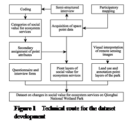 (1) The participatory
mapping method was used to collect spatial point data[11?C13]. First,
after stating the purpose of the interview, the researcher showed the prepared
satellite map images to the interviewees and helped them identify landmark
features to establish a sense of spatial orientation and enhance the accuracy
of subsequent mapping. Secondly, the researchers asked the interviewees questions
about semi-structured interview (a). Finally, with the assistance of the
researcher, the interviewee used self-adhesive stickers to post the places that
have changed greatly in Qionghai in the past 10 years. Meanwhile, the investigators
asked the interviewees about the reasons for posting points in the
semi-structured interview questions (b) and (c) and recorded the
interviews in the semi- structured interview form.
(1) The participatory
mapping method was used to collect spatial point data[11?C13]. First,
after stating the purpose of the interview, the researcher showed the prepared
satellite map images to the interviewees and helped them identify landmark
features to establish a sense of spatial orientation and enhance the accuracy
of subsequent mapping. Secondly, the researchers asked the interviewees questions
about semi-structured interview (a). Finally, with the assistance of the
researcher, the interviewee used self-adhesive stickers to post the places that
have changed greatly in Qionghai in the past 10 years. Meanwhile, the investigators
asked the interviewees about the reasons for posting points in the
semi-structured interview questions (b) and (c) and recorded the
interviews in the semi- structured interview form.
(2) Collection
of basic information from respondents. After completing the participatory
mapping and semi-structured interviews, researchers used questionnaires to
collect basic information about the respondents.
(3)
Semi-structured interview texts were coded to form the categories of social
value for ecosystem services. Based on the grounded theory, the interview text
was coded step by step in the qualitative analysis tool NVivo11, and the
categories of social value for ecosystem services before and after the
construction of Qionghai National Wetland Park were extracted.
(4) The 2019
remote sensing images of Qionghai National Wetland Park were visually
interpreted in ArcGIS to obtain the park??s land use and annotation point
layers.
(5) The
secondary assignment of point attributes forms a point layer of social value
for ecosystem services. When vectorizing the spatial point data obtained
through participatory mapping in ArcGIS, the coding category name is input into
the attribute table of the point layer as a new attribute of the spatial point
according to the affiliation of the coding category, interview text, and
spatial point, forming a social-ecological system service point layer to
provide a basis for subsequent spatial analysis.
4 Data Results and Validation
4.1 Data Composition
Dataset
on changes in social value for ecosystem services on Qionghai National Wetland
Park consists of seven parts, namely: (1) questionnaire and interview outline
of community residents; (2) social and economic characteristics of respondents;
(3) types of social value for ecosystem services before construction of the
park in 2009; (4) types of social value for ecosystem services in the park in
2019; (5) spatial point data of social value for ecosystem services before
construction of the park in 2009; (6) spatial point data of social value for
ecosystem services in the park in 2019; (7) the land use and main annotation
point data. Among them, parts (1) to (4) and parts (5) to (7) of the dataset
are archived in. xlsx and. shp formats respectively.
4.2 Data Results
Through
participatory mapping and semi-structured interview, 1,254 and 2,805 social
value for ecosystem services points were obtained before and after the
construction of Qionghai National Wetland Park, respectively. Clarifying the
spatial pattern changes of social value for ecosystem services can provide
important prerequisites and a basis for sustainable ecosystem management.
Referring to existing studies[11?C13], kernel density mapping was
used to analyze the changes in the spatial pattern of social value for
ecosystem service points before and after the construction of Qionghai National
Wetland Park (Figure 2). The output grid size and search radius were set to 150
m and 1,200 m respectively. The darker the raster color, the higher the density
and the more concentrated the distribution of social value for ecosystem
service points perceived by community residents.
Before the
construction of Qionghai National Wetland Park, Mengxunhuahai Wetland and
Qinglong temple were the highest value areas, while Menglishuixiang Wetland,
Xiaoyu village, Moon Bay and Menghuitianyuan Wetland were the second highest
value areas. Among them, Mengxunhuahai Wetland covers the largest area. Before
the construction of the wetland park, the farmland in Mengxunhuahai Wetland was
distributed continuously, and it was one of the main places for local community
residents to carry out agricultural production. Qinglong Temple, as a famous
local tourist attraction, had farmland and residents settled nearby before the
construction of the wetland park. Local resident could enter and exit Qinglong
Temple freely and carry out various activities, such as fishing, swimming,
boating, setting up stalls, and farming. Therefore, the social value for
ecosystem service perceived by residents were the most concentrated.
After the
construction of Qionghai National Wetland Park, the high-value areas of social
value for ecosystem services perceived by residents are mainly distributed near
Qinglong Temple. The social value for ecosystem services of Mengxunhuahai
Wetland has changed from the high-value area to the second-high value area, and
the remaining second-high value areas are mainly distributed in Menglishuixiang
Wetland, Guanniaodao Wetland and Hetao Village. After the construction of
Qionghai National Wetland Park, the Qinglong Temple was renovated and nearby
communities and farmland were included in the scope of the wetland park for
unified management. The ecological environment around the Qinglong Temple was
improved and Jinlin Beach was developed nearby. As a new attraction, the social
value for ecosystem services perceived by local community residents still forms
a high-value area. Due to the change in land use type after the construction of
the wetland park, the agricultural production value of Mengxunhuahai Wetland
has been significantly reduced. Therefore, the land has changed from a
high-value area before the construction of the wetland park to a second-highest
value area. Overall, the spatial distribution of social value for ecosystem services before and after the construction of the
wetland park has changed from dual-core and multi-point distribution to
single-core and multi-point distribution.
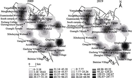
Figure 2 Kernel density maps of social value for
ecosystem services before (2009) and after (2019) the construction of Qionghai National
Wetland Park
5 Discussion and Conclusion
The
dataset on changes in social value for ecosystem services on Qionghai National
Wetland Park has designed a dataset development method suitable for the
collection of ecosystem service value point data and the spatialization of
qualitative data at small and medium scales in multiple stakeholders and
communities based on high-definition map satellite images, semi-structured
interviews and participatory mapping data. The dataset development method
integrates participatory mapping, grounded theory, and secondary assignment of
point attributes. Compared with objective structured data, such as large and
medium-scale remote sensing data and statistical data, which are often used in
traditional methods to measure the value of ecosystem services, it provides a
method reference for accurately identifying and characterizing the changes of
social value for ecosystem services perceived by community residents, as well
as deeply mining and processing complex unstructured qualitative data.
The assessment
of social value for ecosystem services takes community residents as important
stakeholders and focuses on their perceived ecosystem service value. It
provides a community perspective for ecological protection and tourism
development impact assessment and helps to understand the social effects of
protection as well as development activities. This dataset provides kernel
density mapping of social value for ecological system service points, revealing
the changes in social value for ecosystem services and spatial patterns
perceived by community residents before and after the construction of Qionghai
National Wetland Park, which makes up for the shortcomings of the existing
evaluation methods of ecosystem service value. The results of the dataset can
provide data support and useful references for community residents to
participate in the protection and management of Qionghai National Wetland Park
and enhance their well-being. Subsequent studies can conduct thematic mapping
of various social ecosystem service values based on this dataset to further
explore the changes in the social value for ecosystem services perceived by
community residents before and after the construction of Qionghai National
Wetland Park, or expand the research on the social value for ecosystem services
of the region or other similar regions based on the developed methods of this
dataset.
Author Contributions
Zhao,
Z. B. designed the development of the dataset; Zhang, Y. Q. contributed to the
data collection and processing of changes in social value for ecosystem
services on Qionghai National Wetland Park; Feng, X. conducted data
verification; Li, Y. and Feng, X. wrote the data paper.
Conflicts of Interest
The authors
declare no conflicts of interest.
References
[1]
Zhang, Z. Y., Tang, Z. L.,
Zhang, C. H., et al. Bibliometrics-based study of national wetland parks
[J]. Acta Ecologica Sinica, 2023, 43(22): 9555?C9563.
[2]
Song, S., Tian, D. F., Mao, L.
Construction and application of evaluation index system of social functions of
National Wetland Park: a case study of Baiyupao National Wetland Park [J]. Wetland
Science, 2019, 17(2): 237?C243.
[3]
Zhang, Y. Q., Zhao, Z. B., Li,
X. Y., et al. Imapact of Production-Living-Ecological Space change in
suburban protected areas on the social value for ecosystem services: a case
study on Qionghai National Wetland Park [J]. Acta Ecologica Sinica,
2023, 43(16): 6772?C6784.
[4]
Xiao, T., Shi, Q. S, Wen, Y., et
al. Progress and perspectives in the research of wetland ecosystem
services[J]. Chinese Journal of Ecology, 2022, 41(6): 1205?C1212.
[5]
Zhang, Y. C., Mao. X. F., Wei,
X. Y., et al. Wetland and its radiation pattern of the Huangshui
National Wetland Park [J]. Acta Ecologica Sinica, 2022, 42(2): 569?C580.
[6]
Brown, G., Fagerholm, N.
Empirical PPGIS/PGIS mapping of ecosystem services: a review and evaluation
[J]. Ecosystem Services, 2015, 13: 119?C133.
[7]
Bryan, B. A., Raymond, C. M.,
Crossman, N. D., et al. Targeting the management of ecosystem services
based on social values: where, what, and how?[J]. Landscape and Urban
Planning, 2010, 97(2): 111?C122.
[8]
Hernandez, C. A. Theoretical
coding in grounded theory methodology [J]. Grounded Theory Review, 2009,
8(3): 51?C60.
[9]
Li, Y., Feng, X., Zhang Y. Q., et
al. Dataset on changes in social value for ecosystem services on Qionghai
National Wetland Park (2009, 2019) [J/DB/OL]. Digital Journal of Global
Change Data Repository, 2024. https://doi.org/10.3974/geodb.2024.03.04.V1. https://cstr.escience.org.cn/CSTR:20146.11.2024.03.04.V1.
[10]
GCdataPR Editorial Office.
GCdataPR data sharing policy [OL]. https://doi.org/10.3974/dp.policy.2014.05
(Updated 2017).
[11]
Huang,
Y, Zhao, Z.B. Residents?? perception and spatial structure of landscape change
in tourism communities: a case study of Shuhe Old Town
in Lijiang [J]. Journal of Natural Resources, 2018, 33(6): 1029?C1042.
[12]
Chen, C., Zhao, Z.B., Huang, Y.
Social landscape sensitivity analysis of western tourism community: a case
study of Langmusi town in Gannan [J]. Geographical Research, 2017,
36(5): 899?C912.
[13]
Liu, Y., Zhao, Z.B., Li, X. Y.
Landscape value in rural community based on PPGIS: a case study on Shuhe Old
Town of Lijiang [J]. Scientia Geographica Sinica, 2021, 41(2): 328?C339.