Building
an Integrated Toponymic Information System Based on TGIS and Big Data
Technology
Bai, J. T.1 Pan, W.2* Hou, Y. J.3 Zuo, Y. Q.1 Yang, H. H.1
1. Xi??an Map Publishing House, Xi??an 710054, China;
2. Collage of History & Archives, Yunnan
University, Kunming 650091, China;
3. Center
for Historical Environment and Socio-Economic Development in Northwest China of
Shaanxi Normal University, Xi??an 710062, China
Abstract:
Storing toponyms and their historical changes by employing a
scientific approach allows querying them for different historical stages and
realizing their visual representation. Such a toponymic information system can
be exploited for historical and geographical research by integrating temporal
and spatial information utilized for demonstration and analysis tasks. Thus,
this paper builds a toponym database by combining a spatio-temporal framework
and big data technology with a Temporal Geographic Information System (TGIS).
The proposed method supports updating and maintaining toponymic information and
attempts to create a modern information technology that maintains and
broadcasts toponymic information. Specifically, we built a toponym database
including spatial and temporal information and an integrated toponymic
information system that incorporates tools to analyze the information included,
along with a toponym updating mechanism based on big data analysis.
Additionally, our framework provides solutions for various research projects to
reference or confirm each other??s results, improving the extent and depth of
public services based on the relevant results and promoting the integrated
utilization of research results. Finally, our toponymic system affords
revealing historical toponymic information and meeting the asymmetrical and
complementary demands.
Keywords: TGIS; toponym; spatio-temporal framework; visualization;
analysis
DOI: https://doi.org/10.3974/geodp.2021.04.01
CSTR: https://cstr.escience.org.cn/CSTR:20146.14.2021.04.01
1 Introduction
Toponyms are
classified as essential geographical information and are often used to access a
more comprehensive information range. With the advent of the big data analysis
era, toponyms have increasingly been accepted as a critical tool to access data
resources for academic research, information query, and information
interactions[3,4]. The rapidly evolving progress in several aspects
of society, combined with the advancement of big data analysis, artificial
intelligence technologies, and the easiness to access the internet, imposes
quick updates of toponyms and massively transmitting toponymic data through the
internet. Despite the toponyms?? importance, their changes over space and time
have not been explored yet[1]. Therefore, toponym management and its
related services have become challenging recently, as staffs responsible for
collecting, updating, utilizing, maintaining, and managing toponymic data have
to deal with several emerging problems[2].
Toponyms possess three essential features:
space, attributes, and time associated with general geographical phenomena[4].
Temporal toponymic information is irregularly stored or lost due to incomplete
records and historical data storage[5]. Nevertheless, mastering
historical data of geographical objects allows analyzing current data and
retrace the geographical objects?? history to ultimately determine regularities
and predict future development[6–9]. Spurred by the advantages of
maintaining accurate toponymic information, this research introduces big data
analysis technology to build an integrated toponymic information system.
Specifically, we build a spatio-temporal toponym database by adopting semantic
analysis and automatic update technology that relies on big data analysis and spatio-temporal
data modeling theory. Furthermore, we set up an integrated toponymic
information system acting as a tool for spatio-temporal analysis and as a
mechanism to update toponyms.
2 Logical Framework of the System
A spatio-temporal
toponym database based on big data technology and a Temporal Geographic
Information System (TGIS) can provide a framework to establish an integrated
information system[10,11]. The database shall provide researchers
fundamental scientific data and the appropriate tools to search for toponyms
and their relevant fields to deliver better social services. The system
framework diagram is illustrated in Figure 1.
3 Structure of Spatio-temporal Toponymic Data
Considering
toponyms being a type of geographical expression involving nature and human
society attributes, automatic toponym updating has to rely on a spatio-temporal
database of toponyms and an analysis of the spatio-temporal domains. Relevant
data should be obtained from different fields, but different data demands
across various industries and fields impose differences in historical
information mining and description. These differences should be excluded,
narrowed, or employed to confirm each other through semantic analysis and then
act as determinants or supporting evidence during the maintenance and update of
the historical toponymic information. The toponymic spatio-temporal domains
often vary randomly, and thus, the spatio-temporal state and grid model have
been proven quite effective in organizing and managing toponymic
Spatio-temporal data[7]. To facilitate the spatio-temporal analysis
and visual presentation of historical toponyms, we built a spatio-temporal
database based on the GIS spatial topological relation theory, whose conceptual
design is presented in Figure 2.
4 Data Processing
Generating the second-level district grids is
the primary modeling procedure, which exploits modern information technology to
store all toponymic spatio-temporal information and modern cartographic
techniques to visualize the toponymic data. This modeling algorithm improves
the toponymic information storage efficiency and affords information query and
integrated analysis. We adopt the traditional administrative division to fully
exploit the

Figure 1
Framework of the
spatio-temporal toponym database
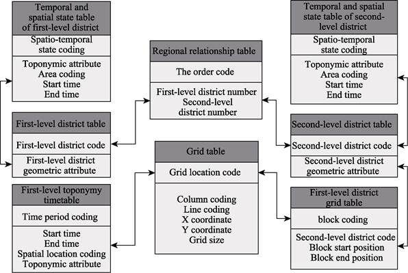
Figure 2 Flow chart of the database development
algorithm??s advantages
and build the basic expression units. Grids that are interconnected within an
administrative district constitute a basic expression unit, for which the
system only needs to record the position codes of two grids: the first and last
ones. Grids are coded from left to right by row according to the attributes of
toponyms and grid locations. Grids that are interconnected and have the same
toponymic attributes constitute a district. If a grid is located at the
boundary of the coding district, it will be classified into the district with
the district??s boundary being redefined. Otherwise, a new district is defined,
and the grid will be used to delimit the boundary of the new district.
The core of the
second-level district indexing is processing toponymic units represented by
polygon vector data. The data processing results are second-level districts,
which are then coded and recorded, and the logical connections between
first-level and second-level grids are identified. Second-level districts are
generated employing the Union tool to deal with administrative district units
and district map layers. Every second-level district is then coded through loop
computation, the logical connections between the first-level and second-level
districts are identified, and their codes are recorded as the digital basis of
the district relationship table. It should be noted that during this process,
the attribute information needs to be maintained to calculate, identify, label,
store, and rank the second-level districts?? grid coordinates.
5 Analysis, Statistics, and Processing of Spatio-temporal
Information of Toponyms
The spatio-temporal
analysis mainly includes locating toponyms in space, along with toponymic
extraction, merging their temporal sequences, calculating their frequency
statistics at specific locations, calculating their accumulative lifetime, and
generating their spatio-temporal volume matrix.
5.1 Locating Toponyms in Space
When a
new toponym is captured by big data analysis technology, its spatial location
is identified based on its spatial attributes. Then the toponym??s temporal
attributes and stories are employed to confirm whether it is a new toponym. If
it is a new one, a new toponym record should is set. Otherwise, it is defined
as historical information of an existing toponym and thus is stored under the
previous toponym.
5.2 Toponym Extraction
According
to relevant standards and regulations, toponyms of administrative districts
generally comprise two names: proprietary and standard. Most databases store complete
toponyms of administrative districts, while the proposed algorithm only
extracts proprietary names and records them as toponyms.
5.3 Merging Time Intervals of Toponyms
Changes of toponyms
related to administrative districts commonly involve their common names, e.g.,
??township?? changed into ??town??, but proprietary names are rarely altered. For
toponyms sharing the same proprietary name, if they refer to the same place,
their time spans should be merged, and the toponym should be stored in the toponymic
record. The process of information merging is as follows: temporal attributes
and common names of coded grids are recorded as the time field and are then
ranked. Adjacent grids sharing the same toponym whose time is successive have
their records merged, with the start and end times of the toponyms determined
based on the time sequences of the grids. If time is ambiguous, then a
synchronous record is created, while if the adjacent grids have no such
connections, the next record will be checked.
5.4 Statistics of Toponym Frequency of
Specific Locations
A
specific grid may include several historical toponyms, potentially being
repeatedly adopted from time to time. All grids are sequentially dealt with,
and all grid records are stored in a timetable with the toponyms ranked based
on their starting time. If one toponym has not yet been included, it is added
to the storage table. Otherwise, it will be dealt with during the following
time interval. This process continues until all grids are considered. Meanwhile,
the boundaries and the total number of toponyms per grid are recorded to form a
matrix comprising grid locations and the total numbers of toponyms. The
toponyms?? changes related to target districts and their coverage are revealed
by combining the initial grid data.
5.5 Toponym Lifetime
According
to the toponyms?? spatio-temporal information statistics, the number of toponym
repetitions, the lifetime of each repetition, and the cumulative lifetime of
one toponym are three significant indicators revealing the historical,
cultural, and regional changes of a place. The lifetime of a toponym refers to
the time duration of a toponym??s spatio-temporal state, with the number of
repetitions and accumulative toponym lifetime involving more complex
definitions. The accumulative lifetime refers to the sum of the same toponym??s
repetition time intervals at the same location. If toponyms are interrupted,
the start and end time of a toponym cycle should be recorded and the number of
interruptions determines the number of toponym repetitions. Nested loop tools
can be used to deal with every toponym and its spatio-temporal state.
5.6 Generation of Spatio-temporal Volume
Matrix of Toponyms
The spatio-temporal
volume matrix involving the spatial coverage of a toponym is the primary target
of the toponyms?? spatio-temporal analysis. The spatio-temporal volume matrix
pipeline is illustrated in Figure 3. According to the district classification
table and the toponym spatio-temporal state table obtained through toponym
retrieval, the spatio-temporal state sequence and district coverage can be
obtained. Then the row and column limits of the toponym??s spatial coverage are
calculated through nested loop processing, and the spatio-temporal state of
every grid is retrieved and added to the accumulative lifetime of the toponym.
The spatio-temporal volume matrix of the toponym is obtained when the cycle is
completed.
6 Visualization of Changes of Spatio-temporal Toponymic
Information
Given the known toponymical data
characteristics, semantic analysis exploits big data analysis information
acquired from different industries. Hence, combining the semantic analysis
results with a toponym??s historical information can confirm whether the toponym
is newly added, altered, removed, or disappears and affords to obtain the spatio-temporal
change process and toponym??s state. To visually represent the dynamic process
statically, several designs are available to represent spatial states,
including dot, line, and plane-type toponyms based on a selection of visual
variables such as shape, size, and color.
Considering that a
toponym change often lacks regularity, static visualization can better describe
the spatio-temporal changes of toponyms, with the latter classified into three
categories according to their spatial states: dot, line, and plane. To
represent toponyms, visual symbols should be selected to present shape, color,
and size variables. The similarities and differences before and after the
toponym changes should also be considered during the design to highlight this
dynamic process.

Figure 3
Flow chart of
generation of spatio-temporal volume matrix of place names
6.1 Visualization of
Spatio-temporal Changes of Dot-type Toponyms
|
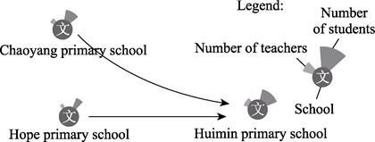
Figure 4 Example of
spatio-temporal changes of dot-
type toponyms
|
Toponyms
may change concerning two aspects: spatial location and attributes. Spatially,
toponyms involve three types of changes: addition, cancellation, and transfer.
The first two change types are easily denoted through symbols, while for the
third one, lines are used to indicate the locations before and after the
??transfer?? and are combined with different colors to create a visual hierarchy.
These are easier visualized regarding the attribute changes, as the toponym
grade change is generally represented by altering the symbol??s size or style.
However, if changes are more complex, symbols are extended to enhance
visualization and exhibit the toponym attributes?? changes based on symbol
alteration. An example is illustrated in Figure 4.
6.2 Visualization of
Spatio-temporal Changes of Line-type Toponyms
In
this work, we utilize lines or colors to visualize spatial location changes of
the line-type toponyms. Figure 5 presents road location changes, mainly
including extension and rerouting.
The line-type toponyms?? attributes changes
are more flexibly visualized utilizing different lines, colors, and line width
combined with annotations (Figure 6).
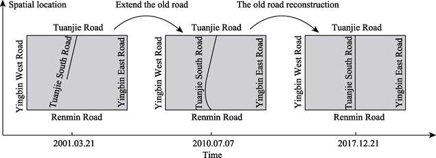
Figure 5
Example of
visualization of spatial changes of a toponym
|

Figure 6
Example of
visualization of changes of toponym changes
|
6.3 Visualization of Spatio-temporal Changes of
Plane-type Toponyms
Plane-type
toponyms present changes in coverage shape, area, and attributes, represented
by visual tools such as color, shape, and map layers. This paper focuses on the
changes in administrative districts. It is assumed that streets should fill one
county-level administrative district, roads, towns, and residential communities
without voids or overlaps in space, and administrative districts at the same
level should be near to, border on, or separate from each other space.
|
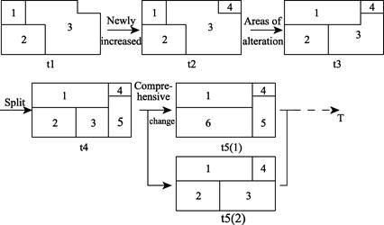
Figure 7
Example of visualization of
location changes of plane-type toponyms
|
The spatial
coverage of a plane-type toponym often changes in multiple directions, which
are generally accompanied by the change of shape or hierarchy and its
attributes. Visualizing plane-type toponyms is more complicated than line
toponyms, and the effect of visualization varies considerably, which is closely
related to the scale and size of the districts. Different colors represent
administrative districts with different toponyms, and the hierarchy of toponyms
is related to the temporal sequences of their adoptions: the later a toponym is
adopted, the higher its hierarchy. This strategy affords directly showing the state
of a plane-type toponym in a specific time and its changing process (Figure 7).
Annotations or
symbols can be added or altered in the mapping space to visualize plane-type
toponym attribute changes. For example, as shown in Figure 8, gross domestic
product (GDP) changes of agriculture, industry, and service sectors in a
specific administrative district can be visualized.
When many
attributes of a plane-type toponym change, such as shape and boundary, several
visualizations should be combined to represent the complicated change, such as
simultaneously adopting color and hierarchy. Hence, we adopt layer opacity to
display the toponyms hierarchy as an auxiliary visualization method in this
work. When maps of different time points
overlap, and according to the user??s discretion, some map layers can be
displayed or hidden to demonstrate a hierarchy, can be shown by reducing or
eliminating interruptions between map layers and expressing target information
accurately. Through adjusting opacity, problems related to information
expression due to multiple overlapping layers are solved. More complicated
changes can also be demonstrated through information charts. Figure 9
illustrates an example of a plane-type toponym visualization.
7 Functions of Integrated Spatio-temporal
Toponymic Information System and Its Management
|
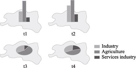
Figure 8 Example of visualization of attributes
of a plane-type toponym
|
7.1 Major Functions of
the Integrated Spatio-temporal Toponymic Information System
The
database comprises nationwide or even worldwide fundamental and historical
toponym data of Shaanxi province. Current historical data originate from
national historical maps in the Historical Atlas of China and historical maps
of Shaanxi province of different dynasties since the Qin dynasty. The
historical information employed includes 9000 pairs of Shaanxi ancient and
current toponyms for comparison, 65,000 important heritage sites in Shaanxi
province, more than 1,000 relics, nearly 200 traditional architectures, more
than 100 ancient tombs, more than 30 religious and cultural sites, and nearly
10,000 locations mentioned in poems. All toponymic information is dynamically
updated by experts who register the platform, with the update speed being
subjected to the toponym management approval authorities and research
achievement publication. The system is updated with the latest research results
utilizing data from different research institutions.
|

Figure 9 Example of visualization of overall
changes of a plane-type toponym
|
This research
adopts big data analysis technology to obtain research results of ancient
toponyms in different industries and fields, ultimately matching ancient
against modern ones. Then the matching results are comprehensively analyzed to
extract the toponyms?? changes and the stories related to each toponym and store
them in a related database. The proposed architecture is illustrated in Figure
10.
The Spatio-temporal toponymical
information database primarily comprises historical map data of well-known
cultural cities in Chinese history, ancient map data, historical images, and spatio-temporal
toponymic data of China. The database is based on technical regulations of data
input and analysis and integrates a cloud model scheme. The database provides
tools for online mapping and visual representation. The proposed architecture
can be generalized to a platform demonstrating the results of a relevant field,
exchange ideas, and manage data, and also it can be exploited by history and
geography researchers for sustainable data mining and production based on GIS.
The integrated spatio-temporal toponymic information system based on the
database has the functions of collection, management, updating, analysis,
visual presentation, downloading, and sharing of toponyms, meeting the
requirements of various fields on query and utilization tasks related to
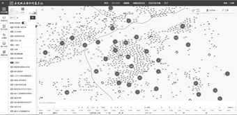
reliable historical toponymic information. Some functions are presented in
Figure 11.
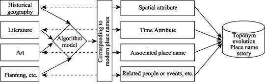
Figure 10
Application of
big data technology in updating toponymical information
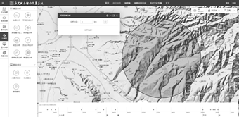
a.
Dataset of historical toponyms b. Visible domain analysis
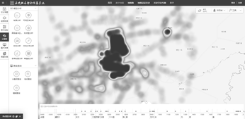
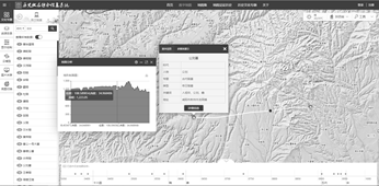
c.
Hot spot analysis d.
Cross-section analysis
Figure
11 Example display of
functions of the integrated spatio-temporal toponymical information system
7.2 Management of the
Integrated Spatio-temporal Toponymic Information System
This
work is part of a project funded by the Ministry of Finance under the ??2016
state- owned capital management budget for state-owned cultural enterprises??,
categorized as the state-owned economy structural adjustment expenditures with
number 2230201. Xi??an Cartographic Publishing House is responsible for
launching and maintaining the project, and participating organizations include
the History and Geography Institute of Shaanxi Normal University, Xi??an
International Studies University, Baoji University of Arts and Sciences,
Capital Normal University, China Institute of Urban and Rural Construction and
Cultural Heritage of Xi??an University of Architecture and Technology, Xi??an
Civil Affairs Bureau, Xi??an Toponym Association, and Shaanxi Provincial
Library. More organizations may be invited to participate in the project
according to work demands.
8 Discussion and Conclusion
The
proposed system allows updating and searching historical toponyms based on big
data analysis technology and TGIS theory, revealing the value of toponyms and
the relevant resources. Our method can easily be extended as a standard data
and search tool for relevant researchers. Additionally, the results obtained can
be edited into popular books to broadcast the related cultures and knowledge to
the public online and offline.
The integrated spatio-temporal
toponymic information system based on TGIS and big data analysis technology
integrates toponym data acquisition, intelligent database maintenance, static
visualization of dynamic data process, toponym query and assistant analysis,
and display and visualization of toponym data or the related results. The
proposed intelligent toponym update theory based on big data analysis
technology supports querying and displaying historical toponyms and is the core
process for the spatio-temporal toponymic information framework and database
presented in this work.
Future work shall
involve expanding the database??s spatial coverage to store more historical
toponyms and along with their relevant data, improving the functions of
intelligent matching ancient with current toponyms, developing toponym
information indexing based on research results of ancient maps and literature,
and creating a server to publicly broadcasting stories of toponyms and focusing
on toponyms with cultural significance. Finally, data acquisition from toponym
research within institutes or management departments should be gradually
improved.
Author Contributions
Bai,
J. T. and Pan, W. designed the algorithms of historical place name
comprehensive information system; Zuo, Y. Q., Yang, H. H. and others contributed
to the data processing and analysis; Bai, J. T. designed the model and
algorithm; Zuo, Y. Q. made data verification; Bai, J. T. wrote the paper.
Conflicts of
Interest
The authors declare no conflicts of interest.
References
[1] Huang, D.
N. Building the query and management system about toponym temporal data based
on TGIS [D]. Fuzhou: Fuzhou University, 2014.
[2] Wang, D. P.
Design and implementation of Guiyang digital place name public service platform
[D]. Chengdu: University of Electronic Science and technology, 2010.
[3] Ren, D. F.,
Xu A. G., Zhu, Y. J. Establishment of Fuxin place name query system [J]. Geospatial Information, 2011, 9(6): 107-110, 1.
[4] Liu, L.,
Lu, J. S. Design and implementation of geographic name information touch query
system based on GIS [J]. Surveying and
Mapping and Spatial Geographic Information, 2012, 35 (10): 110‒112.
[5] Zhang, B.
G., Wang, R. S., Gao, L. Spatio-temporal data model of point place names [J]. Land and Resources Remote Sensing,
2005(4): 82-85.
[6] Zhou, Y.
X., Fu, Z., Liu, D. W., et al. Study
on temporal and spatial process of soil desertification, salinization and
grassland degradation in Western Jilin province [J]. Journal of Jilin University (Geoscience
Edition), 2003 (3): 348-354.
[7] Fu, X. Q.
Research on spatiotemporal state data model of historical geographical names
[D]. Shijiazhuang: Hebei Normal University, 2019.
[8] Smith, B.
Engaging geography at every street corner: using place-names as critical
heuristic in social studies [J]. The
Social Studies, 2018, 109(2): 112-124.
[9] Choi, S. H., Wong,
C. U. I. Toponymy, place name conversion and wayfinding: South Korean
independent tourists in Macau [J]. Tourism
Management Perspectives, 2018, 25: 13‒22.
[10] Zhao, S. H.
Design and implementation of geographic name information integration based on
3S technology [D]. Wuhan: Wuhan University, 2017.
[11] Yao, X.,
Zhu, D., Ye, S., et al. A field
survey system for land consolidation based on 3S and speech recognition
technology [J]. Computers and Electronics
in Agriculture, 2016, 127: 659-668.
[12] Ai. J. H.
Research on place name address matching algorithm [D]. Kunming: Kunming
University of technology, 2019.
[13] Tan, Q. X. Atlas of Chinese History
[M]. Beijing: China Map Publishing House, 1982.