Global Change Data Encyclopedia
Alag Lake, Qinghai-Tibet Plateau, China
Gou, Z. J. Liu, F. G.*
Department of Geographic Sciences, Qinghai Normal University, Xining 810008, China
Keywords: Alag Lake; Qinghai-Tibet Plateau; Qinghai province; freshwater lake; data encyclopedia
The Alag Lake, also known as Alak Nur, is located in the northeast of Qinghai-Tibet Plateau, the southern foot of Burkhambuda Mountain at the eastern end of the East Kunlun Mountains, Qinghai province of P. R. China. It is the largest freshwater lake in Haixi Tibetan and Mongolian autonomous prefecture, and an important inland huff and puff lake in the upper reaches of Qaidam River. Its geographical location is 35°32′45″N-35°36′42″N,
|
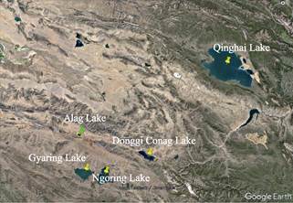
Figure 1 The geo-location of Alag Lake (Google Earth)
|
97°3′53″E-97°10′7″E, and the central point of the lake is 35°34′4.89″N, 97°7′12.64″E. It is 71 km far away from Gyaring Lake, the birthplace of the Yellow River, 77 km from Ngoring Lake, 117 km from Donggi Conag Lake to the east, and 276 km away from Qinghai Lake in its northeast (Figure 1, Figure 2). The Alag Lake is an altitude of 4,100 m above sea level, with the area of 37.35 km2 (2015) and the coastline of 48.53 km (2015)[1–2].
The Alag Lake, in the semi-arid climate area of alpine grassland, has annual precipitation about 100 mm and annual average temperature 0-0.2 oC. The water source is from surface runoff and ice and snow melt water infiltration. There are 5 runoffs into the lake, of which Wusu Uai River is the largest surface runoff supplying Alag Lake. The outflow flows into Wulanwusu River from the east and then into Qaidam River. A large number of peat bogs and springs are distributed around Wulanwusu River on the east side of the lake bank, which is an important part of wetland in the lake region[3].
|
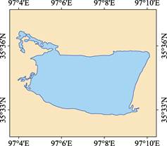
Figure 2 Geo-location of Alag Lake
(.shp format)
|
According to the surrounding environment investigation of the Alag Lake by the Forestry Department of Qinghai Province[4], there are 126 species of spermatophyte belonging to 62 genera, 25 families in the Lake. There are 94 species of vertebrates belonging to 73 genera, 37 families and 13 orders. There are 3 species of birds listed in the first-grade state protection, namely, black-necked cranes, golden eagles, and vultures. There are 14 species listed in the second-grade state protection, including phoenix head, wart-nosed swan, grey crane, black kite, carved owl, great buzzard, grassy eagle, small owl with longitudinal stripes, mountain vulture, vulture, kestrel, Falco subbuteo, falcon and snow chicken with dark belly. There are 14 species of wild birds that are listed as key protected species in Qinghai Province, including gray goose, spotted goose, red duck, cocked-nosed duck, fishing gull, brown-headed gull, (common) cormorant, heron, Tibetan grouse, long-billed lark, (Mongolia) lark, narrow-billed short-toed lark, small lark and horned lark. There are 31 species of protected birds at the provincial and national levels. In addition, there are 17 kinds of animals listed as the national and provincial key protected animals. In 2015, Lake Arak was listed as a national wetland park pilot by the State Forestry Administration[5].
The Alag Lake dataset consists of 15 data files, which are archived in .shp[6] and .kmz[7] formats, with the data size of 267 KB (compressed in 2 data files, 109 KB).
References
[1] Gou, Z. J., Liu, F G. Alag Lake [DB/OL]. Global Change Research Data Publishing & Repository, 2018. DOI: 10.3974/geodb.2018.04.13.V1.
[2] Xi’an Surveying and Mapping General Station, Starmap Press. Map of Qinghai Province [M]. Beijing: Starmap Press, 1999.
[3] Wang, S. M., Dou, H. S. China Lake Record [M]. Beijing: Science Press Ltd., 1998.
[4] Liu, Y. J., Zhu, S. R., Zhou, J. H., et al. Wetland ecological service function of Alag Lake, Qinghai-Tibet Plateau, China—investigation and monitoring of plateau lake ecosystem [A]. Proceedings of the fifth meeting on the lake wetland and green development [C]. 2015: 9-33.
[5] Workers Daily. Construction of wetland park is strengthened in Qinghai province of China [OL]. http://news.sina.com.cn/o/2015-02-09/062031498039.shtml.
Data Computing Environment
[6] ESRI. ArcGIS campus license of Institute of Geographic Sciences and Natural Resources Research, Chinese Academy of Sciences.
[7] Google LLC. Google Earth Pro. 7.3.2.5481 (32-bit), hk.google.com.
URL for Data Downloading
http://www.geodoi.ac.cn/WebEn/doi.aspx?ID=924.
Or search through: http://www.geodoi.ac.cn.