Knowledge Service System on
Disaster Risk Reduction and Its Application
in Social Media Analysis
Wang, J. L.1,2* Han, X. H.1,2 Bu, K.3 Zhang, M.1,2 Wang, X. J. 4,1
Yuan, Y. L.1
1. State Key Laboratory of Resources and
Environmental Information System, Institute of Geographic Sciences and Natural
Resources Research, Chinese Academy of Sciences, Beijing 100101, China;
2. College of Resources and Environment,
University of Chinese Academy of Sciences, Beijing 100049, China;
3. Northeast Institute of Geography and
Agroecology, Chinese Academy of Sciences, Changchun 130102, China;
4. School of Civil and Architectural
Engineering, Shandong University of Technology, Zibo 255049, China
Abstract: Driven by the disaster risk reduction mission of the United Nations
Educational, Scientific and Cultural Organization (UNESCO), Disaster Risk
Reduction Knowledge Service System (DRRKS) was founded under the International
Knowledge Center for Engineering Sciences and Technology (IKCEST) under the
auspices of UNESCO. The system constructs disaster metadata standards and
gathers and produces disaster risk reduction data products. Supported by geographic
information technology, online knowledge applications for disaster risk
reduction have been realized and opened to global users. DRRKS has established
16 online knowledge applications, to mine, analyze, and visualize disaster
information based on big data, such as remote sensing and social media
resources. There was an outbreak of pneumonia associated with the 2019 novel
coronavirus (COVID-19) in Wuhan, Hubei province in China at the end of 2019,
for which DRRKS constructed a knowledge application for public opinion analysis
of disaster events quickly. The application acquired spatial information and
topic semantic information from Sina Weibo texts. Based on the Latent Dirichlet
Allocation model and machine learning algorithm, the spatial-temporal
distribution of Weibo texts related to the novel coronavirus outbreak and
public opinion were analyzed to provide information and application support for
the prevention and control of the novel coronavirus pandemic.
Keywords: disaster risk reduction; knowledge service; social media; public
opinion analysis; COVID-19
1 Introduction
Disaster risk reduction is an urgent global issue. The
United Nations Educational, Scientific, and Cultural Organization (UNESCO) has
long valued global cooperation in this field and has set up the Earth Sciences
and Geohazards Risk Reduction Section in its Department of Natural Sciences.
The International Knowledge Center for Engineering Science and Technology
(IKCEST) was established by UNESCO in China in 2013, and operated by the Chinese
Academy of Engineering. In combination with its positioning and mission, UNESCO
sought close cooperation with IKCEST in disaster prevention and mitigation in
2015. Driven by UNESCO??s mission for disaster risk reduction, IKCEST launched
the construction of a Disaster Risk Reduction Knowledge Service System (DRRKS)
in 2016. It was sponsored by the Institute of Geographical Sciences and Natural
Resources Research, Chinese Academy of Sciences.
2 Disaster Risk
Reduction Knowledge Service System
2.1 Objectives and Vision
To meet the global demand for disaster prevention and
mitigation, DRRKS focused on international/national metadata standards or best
practices and established a global meta-database for disasters by consolidating
data from different kinds of disasters under the unified standard system, as
follows. DRRKS integrates disaster data and information at the national/regional
scale and establishes a disaster database, based on the main types of disasters
in China and its surrounding areas and typical regions of the world. It
establishes an online platform with the support of big data mining and analysis
techniques. Additionally, it mines database development methods and knowledge
information service modes in disaster prevention, rescue, reconstruction,
evaluation, and other aspects, and extensively implements special services,
education and communication, international training, and cooperation in
disaster prevention and mitigation. It also plays a fundamental role in
UNESCO??s disaster prevention and mitigation program[1].
DRRKS
vision is to provide a platform, technology, data, education, knowledge, and other
services for the current global disaster risk reduction, including accumulating
scientific, technological, and academic resources (such as disaster database,
product database, and knowledge base); connecting domestic and international
resources for disaster risk reduction; gathering international typical cases
and application demonstrations for disaster prevention and mitigation;
supporting the application of the Belt and Road Initiative in regional disaster
risk reduction; becoming an important foundation and fulcrum for international
cooperation in disaster risk reduction for UNESCO, and enhancing significantly
the international influence of IKCEST.
2.2
System Architecture
With priority given to the use of open international
technical standards and open-source web technologies, the DRRKS adopts the
technical architecture of an information service platform with on-demand
scalability and a modular mechanism. The iterative development model is
adopted, so the system can be put into use in its developmental life cycle.
Through this system, users can gain quick access to various disaster-related
knowledge resources and subject-specific knowledge services, including data,
maps, literature, experts, institutions, and videos. The overall architecture
of DRRKS is shown in Figure 1.
The data storage scheme
in the bottom layer adopts the Alibaba Cloud computing model to construct the
file server, meta-database server, data server, map server, and web server,
which are used to analyze user access. Supported by a series of open web technologies,
a variety of editing, operation, and maintenance functions are realized,
including data entry, information publishing, permission management. Functions
like cartographic visualization, full-text literature retrieval, analysis of
user behavior, and tag filtering for multiple disaster subjects can also be
performed. This supports knowledge application functions related to the
distribution of disaster organizations and institutions, disaster map browsing,
and subject application for disaster prevention and mitigation.

Figure 1 Platform architecture of the Disaster
Risk Reduction Knowledge Service System
The DRRKS is developed based on the Browser/Server
structure and the application framework of Python + Tornado + TorCMS. For
front-end development, HTML5 and CSS3 technologies are utilized, combined with
the jQuery and Bootstrap 3 framework. The backstage programming language is
Python 3.4 or above. The PostgreSQL database is used to persist the data. The
core attributes are mapped into the database field, and the extended attributes
are stored in the JSONB fields of PostgreSQL. The backstage of WebGIS, which is
applied to the visualization of disaster maps and spatial data, uses MapServer.
On the front-end, the Leaflet and OpenLayers 3 JavaScript databases are
adopted. The software, pycsw, is applied to metadata management. It is an OGC
CSW server implementation written in Python. This CSW standard defines a set of
unified interfaces for the retrieval, query, and browsing of spatial information
and related data[2].
2.3 Product
System
(1) Metadata standards and technical specifications. The
disaster expert database, institution database, video courseware, and other
resources are extended based on disaster core metadata standards research. Meanwhile,
the technical specifications for disaster data management and open services are
formulated.
(2)
Global disaster metabase. Based on the global platform and professional online
database related to disasters, the web crawler technology is used to obtain
metadata information on disasters such as earthquakes, droughts, floods,
typhoons, forest fires, high-temperature heat waves, etc. Natural language
processing, information extraction, and other technologies are used to complete
the word segmentation, filtering, keyword extraction, and other processing of
disaster metadata information. Semantic tag extraction and disaster metadata
classification are completed by combining the controlled vocabulary.
(3)
China disaster map database. The disaster map database is composed of collected
disaster maps in China, which were reorganized, scanned, and processed by
geographic information technology. Each map was re-numbered to ensure its
uniqueness.
(4) Thematic
disaster database. This database was established by remote sensing earth
observation and historical statistical data mining, among others. These include
obtaining land degradation data along the railway between China and Mongolia by
object-oriented remote sensing interpretation, obtaining monthly historical
meteorological regional disaster data from meteorological station data,
obtaining and integrating the disaster datasets of typical megalopolis??s including
Beijing, Shanghai, and Chongqing, etc, since 1949.
(5)
The Belt and Road disaster database. This database integrates the background
data of 65 countries and regions along with the Belt and Road project,
including basic national conditions, natural resources, and social economy.
Based on remote sensing data and network resources, the loss degree data from
high-temperature heat waves, floods, and earthquakes along the China-Pakistan
Economic Corridor are collected, mined, and compiled. The risk distribution
dataset for rainstorms and flooding and the extreme precipitation event dataset
in the adjacent areas of China and Russia are obtained using remote sensing and
ground monitoring.
(6)
The thematic database supporting SDGs. Addressing the problems of forest management,
land degradation, and other major environmental and ecological resources in
SDG15, the dataset products for SDG15.1 and SDG15.3 were obtained by using
remote sensing and big data technology. For example, the database included regional
forest classification data products in China, desertification data products in
Mongolia, and land salinization and degradation data in the Yellow River Delta
in China, etc.
(7)
Construction of general resources. Regarding relevant data norms and standards,
norms and standards, and disaster databases (expert, institution, literature,
and video courseware), global engineering cases and other content construction
will be carried out continuously and will be open to users through information
sharing and knowledge application tools.
2.4 User
Service
The DRRKS team carries out user services continuously. Main
users are divided into five categories: 1) UNESCO and other international organizations
or institutions; 2) relevant government agencies and management technicians for
disaster prevention and mitigation; 3) scientific and technological researchers
engaged in disaster prevention and mitigation; 4) teachers and students of
higher education institutions; 5) the public. The number of user visits reached
13,000 per month, nearly 50% of which came from countries outside China, mainly
the United States, Japan, India, the Philippines, the United Kingdom, and other
countries.
3 Online Knowledge Application
Online knowledge application is a
typical application mode provided by the DRRKS. Attracted by specific
application needs, it provides user interaction and displays through data
integration processing and visualization technology support. Currently, 16
online knowledge applications have been developed and deployed. These can be
found and accessed on the homepage of DRRKS (http://drr.ikcest.org), shown in Figure 2 and Table 1.
4 Application of
COVID-19 Public Opinion Analysis
4.1 Data
Pre-processing
(1) Data collection. Sina-Weibo
(http://us.Weibo.com), often referred to as Weibo, is one of the most popular
social media platforms in China with over 516 million active users each month
in 2019. Using Weibo Application Programming Interfaces (APIs), Weibo messages
related to COVID-19 were collected with ??pneumonia?? and ??coronavirus?? as the
keywords in this study. The following information was extracted finally: user
ID, timestamp (i.e., message posted time), text, and location information.
(2) Data pre-processing. The original Weibo texts contain interfering
information such as hyperlinks, spaces, punctuation marks, hashtags, and
@users. Text filtering was thus necessary to eliminate noise and improve the
efficiency of word segmentation. These types of interfering information were
removed by regular expression operations (??re?? module) in Python. Very short Weibo texts (less than four words) and
duplicates were deleted. Word segmentation was necessary because there are no
obvious separators between Chinese words. A Python package for Chinese text
segmentation called ??Jieba?? was utilized. By building a user dictionary
including keywords related to COVID-19, the package segmented words efficiently.

Figure 2 Picture of the homepage of DRRKS system
Table 1 DRRKS system online
knowledge application list
|
No.
|
Name of
knowledge application
|
Online address
|
Service function
|
|
1
|
Knowledge map service for major disaster
risk reduction organizations
|
http://drr.ikcest.org/app/s8349
|
Obtain global disaster risk
reduction organization list and provide online visualization and one-stop
navigation services
|
|
2
|
Global earthquake daily distribution
map service
|
http://drr.ikcest.org/app/s9834
|
Through the real-time USGS interface,
global earthquake distribution data can be obtained and displayed visually
online
|
|
3
|
Map visualization services of China??s
historical disasters
|
http://drr.ikcest.org/app/s7834
|
Obtain historical maps, publish them
visually after scanning and correction, and provide editing function
|
|
4
|
Chinese and international experience
in natural disaster relief
|
http://drr.ikcest.org/case/index.html
|
Collect global typical cases and
show them in terms of pre-disaster prevention, disaster relief, and post-disaster
reconstruction
|
|
5
|
Forest freezing, rain and snow disaster
prevention and reduction in southern China
|
http://drr.ikcest.org/knowledge_service/
forest.html
|
Use Anusplin software to perform
spatial discretization and provide visualization services
|
|
6
|
Flood control in Songliao basin
|
http://drr.ikcest.org/knowledge_service/
control_flood.html
|
Provides the spatial distribution
display and analysis services of flood disaster data and information based on
WebGIS
|
|
7
|
Spatio-temporal distribution of
arable land drought along ??the Belt and Road initiatives?? project area
|
http://drr.ikcest.org/knowledge_service/
drought.html
|
Establish a drought model of precipitation
anomaly percentage to provide the display of cultivated land distribution and
analysis of spatiotemporal sequences
|
|
8
|
Suspended solids concentration inversion
from 2000 to 2013 in Poyang Lake, China
|
http://drr.ikcest.org/knowledge_service/
poyang_lake.html
|
Data modeling and inversion of the
four seasons of Poyang Lake, forming a visual analysis of spatio-temporal
sequences over many years
|
|
9
|
Annual spatial distribution data for
drought monitoring in the Mongolian Plateau (1981‒2012)
|
http://drr.ikcest.org/knowledge_service/
mongolian.html
|
A stable drought monitoring model
was constructed based on the universal feature space of Ts-NDVI to realize
the analysis of spatio-temporal sequences for many years
|
|
10
|
Spatial distribution of the seasonal
chlorophyll-a concentration in Poyang Lake, China (2009‒2012)
|
http://drr.ikcest.org/knowledge_service/
poyang_yls.html
|
Semi-empirical and empirical methods
were used to obtain the estimation model of chlorophyll-a concentration in
Poyang Lake and render a visual analysis
|
|
11
|
Total factor data of land cover in disaster
environment in Mongolia
|
http://drr.ikcest.org/knowledge_service/
mongolian_lc.html
|
Distribution
of various types of land cover elements is obtained using object-oriented
interpretation methods and visual analysis
|
|
12
|
Spatio-temporal distribution of major
historical disasters in the China- Mongolia-Russia Economic Corridor
|
http://drr.ikcest.org/knowledge_service/
zmezl.html
|
Collection of multi-source disaster
data and information and provide visual display and analysis
|
|
13
|
Temporal and spatial distribution of
public sentiment on Shouguang flood
|
http://drr.ikcest.org/knowledge_service/
shouguang.html
|
Topic extraction and classification
using Weibo text big data, LDA topic model, and random forest algorithm
|
|
14
|
Hazard-formative environments
knowledge service of ??the Belt and Road initiatives?? project
|
http://drr.ikcest.org/knowledge_service/
the_belt_and_road.html
|
Obtain basic national condition
information of countries along the Belt and Road project through multi-source
means such as internet, text, statistics, etc., and display and service
online
|
|
15
|
Grassland yield in ??the Belt and
Road initiatives?? China-Mongolia-Russia Economic Corridor
|
http://drr.ikcest.org/knowledge_service/
grassland_yield.html
|
Establish a
grass yield estimation model along the China-Mongolia railway (Mongolia
section) to obtain long-term serial products and visualize them
|
|
16
|
Public opinion analysis for COVID-19
|
http://drr.ikcest.org/knowledge_service/
ncp.html
|
Obtain and visualize public opinion
in China during the outbreak of COVID-19 based on Sina Weibo big data
|
4.2 Topic Extraction and Classification
A topic extraction and classification model combining the
LDA model and the random forest (RF) algorithm was used to hierarchically
process COVID-19-related Weibo texts[3]. As shown in Figure 3, the
first step was to mine and generalize the topics from the COVID-19- related
Weibo entries[4] based on the Gensim package in Python, from which
the topic-terminology and document-topic lists were obtained. The first level
topics were generalized into seven topics: events notification, popularization
of prevention and treatment, government response, personal response, opinion, and
sentiments, seeking help and making donations.
Then, topic extraction results were utilized as training samples for the RF algorithm[5]
to classify the Weibo data. The RF algorithm was implemented by a machine
learning package named ??scikit-learn?? in Python. Finally, a secondary
classification was implemented to divide the broad topic into more detailed
sub-topics.
|
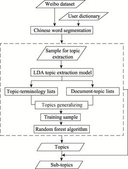
Figure
3 The
processes of topic extraction and classification
|
4.3 Temporal-spatial
Analysis
Taking the Weibo text information of the new coronavirus
pneumonia from January 9, 0:00 to January 31, 24:00, 2020 as an example,
648,013 pieces of relevant information were initially obtained, including
55,260 pieces with geographic coordinates and located in China. Figure 4 is a
time series analysis of the number of Weibo texts related to the pandemic. On
January 9th, the pneumonia pathogen was initially identified as a
novel coronavirus. The Weibo attention volume remained stable and slightly increased.
On January 20th, the central government of China issued the highest
instructions for novel pneumonia, and academician Zhong Nanshan confirmed that novel
pneumonia had the characteristic of person to person transfer. The number of
Weibo texts concerning the pandemic started to rise sharply, reaching a peak on
the January 21st. Due to the impact of the Chinese Spring Festival
holiday, the volume of attention dropped until January 29th. In this
period, the response measures of the lockdown of Wuhan and some provinces such
as Guangdong, Zhejiang, and Hunan also brought significant fluctuations in
Weibo information. On January 31st, the WHO announced that the
epidemic constituted a public health emergency of international concern, which also
affected the change in the time trajectory of Weibo information.
|

Figure
4 Time
series of Weibo texts daily
|
Figure 5 is a spatial
statistical map by province, showing that the main public opinion hotspots are
concentrated in seven provinces including Hubei, Shandong, Henan, Jiangsu,
Zhejiang, Sichuan, and Guangdong. Taking 200 km as the search radius and using
the kernel density analysis method, a visual distribution map of public
opinion related location information on the epidemic was formed (Figure 6). It
shows that hotspots are prominently concentrated in the triangular high-value
areas with the core hotspots in the Hubei-Henan border area, the Hebei-Shandong
border area, the Jiangsu- Zhejiang-Anhui border area, as well as two
independent hotspot areas in Sichuan and Guangdong.
|
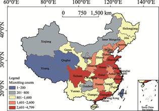
Figure 5 Spatial statistical map of
epidemic-related
microblogs
by province
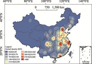
Figure 6 Kernel density analysis of
epidemic-related
Microblogs
|
5 Conclusion
The DRRKS has been activated online. Users can query,
browse, and download resources for disaster risk reduction in DRRKS. As of the
end of 2019, the DRRKS has provided the public with services of 167 datasets,
1,050 thematic maps, 90,000 metadata, 15 knowledge applications, and 220,000
documents. In response to the current urgent novel coronavirus pandemic, the
DRRKS quickly built an online knowledge application of disaster public opinion
analysis, publishing sharing, and visualizing services in the knowledge application
module. This platform will continually provide support for experts and scholars
in the fields of disaster mitigation and public health.
Acknowledgments
A special acknowledgment should be expressed to
all the DRRKS team members, the Secretariat of IKCEST, and the experts of
UNESCO??s Earth Sciences and Geo-hazards Risk Reduction section.
References
[1]
Wang, J.,
Bu, K., Yang, F., et al. Disaster
risk reduction knowledge service: a paradigm shift from disaster data towards
knowledge services [J]. Pure and Applied
Geophysics, 2020, 177(1): 135-148.
[2]
Wang, Y. J.,
Bu, K., Wang, J. L. Design and prototype implementation of disaster metadata
management system based on open-source pycsw [J]. E-science Technology & Application,
2018, 9(2): 60-70.
[3]
Han, X., Wang, J. Using social media to mine and analyze public
sentiment during a disaster: a case study of the 2018 Shouguang city flood in
China [J]. ISPRS International Journal of
Geo-Information, 2019, 8(4): 185.
[4]
Blei, D. M.,
Ng, A. Y., Jordan, M. I. Latent dirichlet allocation [J]. Journal of Machine Learning Research, 2003, 3(1): 993-1022.
[5]
Breiman, L.
Random forests [J]. Machine Learning,
2001, 45(1): 5-32.