Global Change Data Encyclopedia
Gyaring Lake, Qinghai-Tibet Plateau, China
Gou, Z. J. Liu, F. G.*
Department of Geographic Sciences, Qinghai Normal University, Xining 810008, China
Keywords: Gyaring Lake; Yellow River; Dear Island; Qinghai-Tibet Plateau; data encyclopedia
|

Figure 1 The Geo-location of Gyaring Lake (.kmz format)
|
|
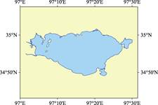
Figure 2 Data visualization of Gyaring Lake (.shp format)
|
Gyaring Lake is also known as Charing Sea or Cuojialang in Tibetan language. The Yellow River carries a lot of sediment into the lake, and the lake surface is grayish white when the wind and wave appear. Therefore, the name of the lake means “grey white lake” in Tibetan language. Gyaring Lake is located in the valley of Yellow River and belongs to Madoi county, Qinghai province, China. It is a huff and puff freshwater lake. Gyaring Lake and Ngoring Lake are called “Sister Lakes” in west-east direction in the source region of Yellow River (Figure 1)[1]. Maqu River, the origin of Yellow River, flows into Gyaring Lake at its west and flows out from its southeast, and then flows into Ngoring Lake after joining with Duoqu River. The segment of Yellow River between Gyaring Lake and Ngoring Lake is 28.26 km.
The Lake is in the shape of asymmetrical diamond, with 40 km long in west-east direction and 23 km wide in north-south direction. The Lake is surrounded by mountains. The beaches both in the south and north sides are wide, with gentle topography, while the east coast is steep. The geo-location of Gyaring Lake is 34°49′08′′N–
35°01′37′′N, 97°01′27′′E–97°30′04′′E (Figure 2). There are 11 islands in Gyaring Lake. Three islands, located in the northwest of the lake, are lined up from north to the south, so their name is called “West Three Islands”. In addtion, as there are more than 60 white-lipped deer inhabiting there, it is also called “Deer Island”. Among the three islands, the North Island is the largest island in the lake, with an area of 1.35 km2 and a shoreline of 5.18 km. The area of the Middle Island is 0.86 km2, and the shoreline is 4.28 km, while the South Island is 0.41 km2, and the shoreline is 2.60 km. The area of the Gyaring Lake catchment is 542.33 km2, and the lakeshore is 232.20 km. The water depth is 1–13 m and the elevation is 4,290 m[2].
The precipitation and ice-snow melting water are the main sources of Gyaring Lake, with the annual average precipitation of 321.6 mm (Table 1). There are a few larger surface runoffs flowing into the lake, including Longlajia Riji, Kangqian, Kangqianduote, Kangqian, and Yuri Cailong[6–7]. The plants in the area belong to the Tanggu Special Zone of the sub-region of the Qinghai-Tibet Plateau. The herbaceous plant communities mainly include Kobresia tibetica, Blysmus sinocompressus, and Triglochin martimum, while the sub-dominant plants are Carex moorcroftii, Carex atrofusca, etc. Wild animals in the lake include the cladocerans and copepods of the zooplankton, fish, waterfowl, etc.[3].
In 635 A. D. (Tang Dynasty), Songtsen Gampo, the Tibetan king, came here to welcome Princess Wencheng to Tibet[7].
The dataset was developed based on Google Earth (2015) and related maps. The dataset is archived in .kmz and .shp[8] formats and consists of 22 files with a data size of 6.69 MB (compressed to two files, 2.29 MB).
Table 1 The average temperature (oC) and precipitation (mm) of Madoi county[4–5]
|
Parameter
|
Jan.
|
Feb.
|
Mar.
|
Apr.
|
May
|
Jun.
|
Jul.
|
Aug.
|
Sep.
|
Oct.
|
Nov.
|
Dec.
|
Annual average
|
|
Temperature
|
–16.8
|
–13.4
|
–8.2
|
–3.0
|
1.7
|
5.2
|
7.5
|
7.2
|
3.3
|
–2.9
|
–11.0
|
–15.7
|
–3.8
|
|
Precipitation
|
3.6
|
4.8
|
5.7
|
11.0
|
31.2
|
59.2
|
72.7
|
59.6
|
46.8
|
18.6
|
2.9
|
2.5
|
321.6
|
References
[1] Xie, Y. Science Museum of Natural Geography (China): the First Series [M]. Xi’an: Xi’an Cartographic Publishing House, 2009.
[2] Gou, Z. J., Liu, F. G. Gyaring Lake [DB/OL]. Global Change Research Data Publishing & Repository, 2018. DOI: 10.3974/geodb.2018.03.13.V1.
[3] Han, R. Annal of Qinghai Province: Source of Yangtze River, Yellow River, and Lanchang River [M]. Zhengzhou: Yellow River Water Conservancy Press, 2000.
[4] Editorial Office of County Annals of Madoi. County Annals of Madoi County [M]. Beijing: China County and Town Yearbook Publishing House, 2001: 59.
[5] Editorial Office of local chronicles of Madoi County. County Annals of Madoi County [M]. Xining: Qinghai Ethnic Publishing House, 2011: 34–35.
[6] Ma, Y. X. Main Grassland Nature and Cultural Resources of China [M]. Beijing: China Agriculture Press, 2012.
[7] Editorial Office of Encyclopedia of Rivers and Lakes in China. Encyclopedia of Rivers and Lakes in China: Yellow River [M]. Beijing: China Water & Power Press, 2014.
Data Computing Environment
[8] ESRI. ArcGIS campus license of Institute of Geographic Sciences and Natural Resources Research, Chinese Academy of Sciences.
URL for Data Downloading
http://www.geodoi.ac.cn/WebEn/doi.aspx?Id=880.
Or search through: http://www.geodoi.ac.cn.