Time Series Dataset of Wuhan East Lake Changes (1990‒2020)
Liu, X. Q.1 Ma, B. W.2 Wang, X.2 Li, D.3 Chen, K. L.4*
1. School of Environmental Studies, China University of
Geosciences, Wuhan 430074, China;
2. School of Geography and Information Engineering, China
University of Geosciences, Wuhan 430074, China;
3. Institute of Geography and Tourism, Guangdong University
of Finance & Economics, Guangzhou 510320, China;
4. School of Physical Education, China University of
Geosciences, Wuhan 430074, China
Abstract: East Lake of Wuhan exists as a large urban lake in the eastern
fringe of Wuhan, a comprehensive mega city. This area had experienced rapid
urbanization in recent years, and it is an ideal area to study the changes of
urban water body under the progress of rapid urbanization. Based on the Landsat
Image (with a spatial resolution of 30 m), the data of the water body for East
Lake is extracted based on the Modified Normalized Difference Water Index (MNDWI)
and refined by referring to the images on Google Earth. Then the final data for
1990, 1995, 2000, 2005, 2010, 2015 and 2020 are obtained. The statistical
results show that the water body of the East Lake had shrunk by 14% (5.10 km2),
and the shoreline length had been reduced by 22% (43.47 km). The dataset is archived
in .shp and .kmz formats in seven files with the data size of 1.91 MB.
Keywords: East Lake; water body
change; area; shoreline length; Wuhan
DOI: https://doi.org/10.3974/geodp.2021.02.05
CSTR: https://cstr.escience.org.cn/CSTR:20146.14.2021.02.05
Dataset Availability Statement:
The dataset
supporting this paper was published and is accessible through the Digital Journal of Global Change Data
Repository at https://doi.org/10.3974/geodb.2021.04.06.V1 or
https://cstr.escience.org.cn/CSTR:20146.11.2021.04.06.V1.
1 Introduction
As
an important part of urban wetland system, urban lake plays an important role
in urban development, ecosystem balance and flood control[1?C3]. In
recent years, with the continuous progress of urbanization, the expansion of
urban built-up areas had brought economic prosperity to the urban waterfront.
However, there are bad influences such as the aggravation of water
pollution, the decline of flood control capacity, the deterioration of
ecological security and the reduction of biodiversity[4,5].
East Lake of Wuhan is located on the South Bank of the
Yangtze River Basin, with a water area of about 30 km2, which is six
times larger than the West Lake in Hangzhou. Before 2014, East Lake was the
largest urban lake in China[6]. With the rapid development of
society and economy, Wuhan had undergone a rapid urbanization process after the
reform and opening up. The central city had been expanding continuously, as a
result, the water body of East Lake had been occupied and the area is
increasingly shrinking. After 2014, East Lake had been ranking as the second
largest urban lake in China, after Tangxun Lake also in Uwhan. It is good for
the protection of Lake wetland system, the coordination of urban development,
environment and urban landscape planning and management to know the water body
change process of East Lake for the reason that East Lake is one of the most
typical urban lakes in the Yangtze River Basin and even in China.
In this study, seven periods of remote sensing image data
of East Lake from 1990 to 2020 were collected. The remote sensing image of
water body was extracted and modified by means of ENVI and ArcGIS platform. The
1990?C2020 morphological change dataset is achieved by calculating the area and
shoreline length.
2 Metadata of the Dataset
The metadata of the Time Series Dataset of Wuhan East Lake
Changes (1990‒2020)[7] is summarized in Table 1[8].
3 Methods
3.1 Raw Data
The data of this study is obtained from USGS website.
The spring and summer in the research area are rainy seasons and rains
frequently and heavily. Therefore, the cloud in the remote sensing image is
dense and the boundary of the water body is not clear. Therefore, the remote
sensing data in the season with little rain in autumn and winter are selected
in this study to avoid the above problems.
This study selected seven Landsat
remote sensing images, including 1990/09/02, 1995/08/31, 2000/09/13,
2005/09/11, 2010/12/30, 2015/10/12, 2020/08/03 (column number 123/039, with cloud
cover below 10%), to extract the water body information of East Lake in Wuhan[10].
3.2 Algorithm Principle
(1) Based on ENVI software, the Modified Normalized
Difference Water Index (MNDWI) was used to extract the water body of East Lake[10,11]:
?? the remote sensing image is preprocessed by
radiometric calibration and atmospheric correction; ?? calculate MNDWI index; ?? judge whether there are abnormal values, if
there are abnormal values, eliminate the abnormal values; ?? by adjusting the parameters and combining with
the existing domestic research, the threshold value is set to 0.2 to separate
land from water; ?? extracting water
body data.
(2) Based on the ArcGIS technology platform and combined
with the data correction of Google Earth image in the same period, the smooth
tool in ArcGIS software was used to smooth the jagged boundary in the
interpretation and make it closer to the actual boundary. After tests, it can
be seen that when the smoothing tolerance is 90 m, it is closest to the actual
boundary. After finishing the boundary smoothing work, the extracted data were refined
by referring the Google Earth images of the same period.
(3) The area and
shoreline length of East Lake in different periods are calculated by using the
calculation tools of ArcGIS.
Table 1
Metadata summary of the Time series
dataset of Wuhan East Lake Changes (1990‒2020)
|
Items
|
Descriptions
|
|
Dataset
full name
|
Dataset
of water changes in East Lake of Wuhan (1990‒2020)
|
|
Dataset
short name
|
EastLake_1990-2020
|
|
Authors
|
Liu,
X. Q., School of Environmental Studies, China University of
Geosciences, Wuhan, dancy_cug@163.com
Ma,
B. W., School of Geography and Information Engineering, China
University of Geosciences, Wuhan, m.bowen@foxmail.com
Wang,
X., School of Geography and Information Engineering, China
University of Geosciences, Wuhan, jorrywangxu@163.com
Li,
D., Institute of Geography and Tourism, Guangdong University of
Finance & Economics, danl_163@163.com
Chen,
K. L., School of Physical Education, China University of
Geosciences, Wuhan, chenkl@cug.edu.cn
|
|
Geographical
region
|
Hongshan
district of Wuhan city Year 1990?C2020
|
|
Spatial
resolution
|
30 m
Data format .shp
|
|
Data
size
|
1.91
MB (compressed to 1 file, 1.07 MB)
|
|
Data
files
|
Water
data of East Lake in 1990/09/02, 1995/08/31, 2000/09/13, 2005/09/11,
2010/12/30, 2015/10/25 and 2020/08/03
|
|
Foundation(s)
|
Ministry of Education of P. R. China (CUG2018123)
|
|
Data
computing environment
|
ENVI
and ArcGIS
|
|
Data
publisher
|
Global
Change Research Data Publishing & Repository, http://www.geodoi.ac.cn
|
|
Address
|
No.
11A, Datun Road, Chaoyang District, Beijing 100101, China
|
|
Data
sharing policy
|
Data from
the Global Change Research Data Publishing & Repository includes metadata, datasets
(in the Digital Journal of Global Change Data Repository), and
publications (in the Journal of Global Change Data & Discovery). Data sharing policy
includes: (1) Data are openly available and can be free downloaded via the
Internet; (2) End users are encouraged to use Data subject to
citation; (3) Users, who are by definition also value-added service
providers, are welcome to redistribute Data subject to written permission
from the GCdataPR Editorial Office and the issuance of a Data redistribution
license; and (4) If Data are used to compile new
datasets, the ??ten per cent principal?? should be followed such that Data
records utilized should not surpass 10% of the new dataset contents, while
sources should be clearly noted in suitable places in the new dataset[9]
|
|
Data
and paper retrieval system
|
DOI,
CSTR, Crossref, DCI, CSCD, CNKI, SciEngine, WDS/ISC, GEOSS
|
4 Data Results
|
Table
2 Area and Perimeter Shoreline Length of East
Lake (1990‒2020)
|
|
Year
|
Area (km2)
|
Perimeter (km)
|
|
1990
|
35.57
|
198.58
|
|
1995
|
34.40
|
201.08
|
|
2000
|
33.40
|
181.18
|
|
2005
|
32.27
|
179.19
|
|
2010
|
31.61
|
175.44
|
|
2015
|
31.27
|
178.52
|
|
2020
|
30.48
|
155.11
|
This
dataset contains seven periods of water body data of East Lake of Wuhan in
1990, 1995, 2000, 2005, 2010, 2015 and 2020, which show the water body changes
of the East Lake during the most recent 30 years.
The
dataset indicates that the water area of Wuhan East Lake had changed
significantly from 1990 to 2020 (Table 2, Figure 1), it shrunk from 35.57 km2
in 1990 to 30.48 km2 in 2020, and the lake area decreased by
14% (5.1 km2) from 1990 to 2020. In
addition, the shoreline length of East Lake had been decreasing in the past 30
years and increasing in some years. The shoreline length was 198.58 km in 1990
and reduced to 155.11 km in 2020. Up to 2020, the shoreline length of East
Lake had decreased by 22% (43.47 km). In general, the decrease of
shoreline mainly occurred in 1995‒2000 and 2015‒2020.
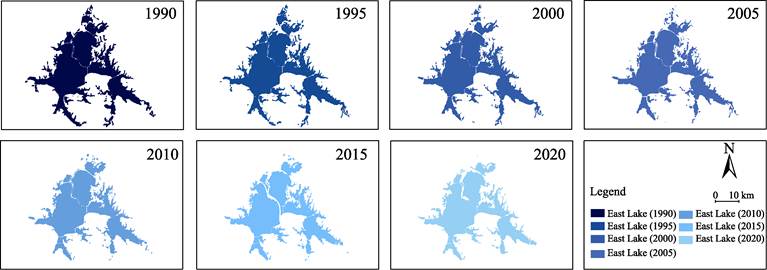
Figure 1 Maps of morphological evolution of East
Lake (1990‒2020)
From 1990 to 1995, the area of East
Lake decreased from 35.57 km2 to 34.40 km2, with a
decrease rate of 3% (1.17 km2), and the shoreline length increased
slightly from 198.58 km to 201.08 km. During this period, a small amount of
water body of East Lake was occupied, which reduced the water area in the north
and southeast. The occupied part of the water body made the shoreline of East
Lake more complex and the water bodies more fragmented.
From 1995 to 2000, the area of East Lake decreased from
34.40 km2 to 33.40 km2, with a reduction rate
of 3% (1 km2), and the shoreline length also decreased from
201.08 km to 181.18km, with a reduction rate of 10% (19.90 km). During
this period, the area decrease mainly occurred in the northeast coastal area of
East Lake, and the occupied part of the water body was mainly in sheet shape,
making the shoreline of the northeast part of the water body tend to be simpler.
From 2000 to 2005, the area of East Lake decreased from
33.40 km2 to 32.27 km2, with a reduction rate of 3% (1.13
km2), and the shoreline length slightly decreased from
181.18 km to 179.19 km, with a reduction rate of 1% (1.99 km). During
the past 5 years, the area of East Lake decreased sporadically in coastal
villages, which occupied a small amount of East Lake water, reducing the area
of East Lake water and shortening the shoreline.
From 2005 to 2010, the area of East Lake decreased from
32.27 km2 to 31.61 km2, with a decrease rate of
1% (0.66 km2), and the shoreline length decreased from 175.44 km to
175.44 km, with a decrease rate of 2% (3.75 km). During this period,
the water body in the north and southeast of the East Lake was obviously
encroached, which reduced the area and shoreline length of East Lake.
From 2010 to 2015, the area of East Lake reduced from
31.61 km2 to 31.27 km2 and the reduction rate
is 1% (0.34 km2). The shoreline length increased from 179.19 km
to 178.52 km, with a growth rate of 2% (3.08 km). During this period, the water
body along the north bank of East Lake continued to be occupied, and the shape
of the water body changed due to the construction of tunnels in the lake.
From 2015 to 2020, the area of East Lake reduced from 31.27
km2 to 30.48 km2, with a decrease rate of 1.4% (5.10 km2),
and the length of shoreline reduced from 178.52 km to 155.11 km, with a
decrease rate of 22% (23.41 km). During this period, the change of water body
of East Lake mainly occurred in the outer boundary of the water area, which
reduced the area and simplified the shoreline.
5 Conclusion
As the most typical urban lake in the Yangtze River Basin
and even in China, East Lake plays an important role in the urban development,
flood control and storage, and even ecological security of Wuhan[12,13].
It is more necessary to understand the evolution of East Lake morphology. Based
on Landsat remote sensing images and Google Earth images from 1990 to 2020, we
extracted the water data of East Lake with ENVI and ArcGIS platforms. On this
basis, the water area and shoreline length of East Lake in different years were
calculated to determine the water changes of East Lake. The dataset of East
Lake water changes in Wuhan plays a vital role in studying the morphological
evolution of East Lake, understanding the characteristics of urban development
stage in Wuhan, analyzing the ecological security pattern of East Lake and its
surrounding areas and regional
environment protection, and is also an indispensable geographical basic
data.
Author
Contributions
Liu, X. Q., and Chen, K. L. designed the algorithms of
dataset. Ma, B. W., Wang, X., and Li, D. contributed to the data collection.
Liu, X. Q., and Ma, B. W. contributed to the data processing and analysis. Liu,
X. Q. wrote the data paper. Chen, K. L. revised the data paper.
Conflicts of Interest
The authors declare no
conflicts of interest.
References
[1]
Chen, K.
L., Qi, M., Wang, X., et al. Study of
urban lake landscape ecological security pattern evolution in Wuhan, 1995?C2015
[J]. Acta Ecologica Sinica, 2019, 39(5):
1725‒1734.
[2]
Chen, K. L., Liu, X. Q., Chen, X., et al. Spatial characteristics and driving forces of the
morphological evolution of East Lake, Wuhan [J]. Journal of Geographical Sciences, 2020, 30(4): 583‒600.
[3]
Xie, Q. J.,
Liu, J. H. Spatio-temporal dynamics of lake distribution and their impact on
ecosystem service values in Wuhan urbanized area during 1987?C2016 [J]. Acta Ecologica Sinica, 2020, 40(21):
7840‒7850.
[4]
Liang, C.
M., Zhang, X., Li, Z. L., et al.
Temporal and spatial evolution characteristics of river and lake system in the
urbanization process of Wuhan city [J]. Journal
of North China University of Water Resources and Electric Power (Natural Science Edition), 2019, 167(6):
65‒72.
[5]
Kong, L.
Q., Zhang, L., Zheng, H., et al.
Driving forces behind ecosystem spatial changes in the Yangtze River Basin [J].
Acta Ecologica Sinica, 2018, 38(3):
741‒749.
[6]
Chen, K.
L., Wang, X., Li, D., et al. Driving
force of the morphological change of the urban lake ecosystem: A case study of
Wuhan, 1990?C2013[J]. Ecological Modelling, 2015, 318: 204‒209.
[7]
Liu X. Q.,
Ma B. W., Wang X., et al. Time series
dataset of Wuhan East Lake changes (1990‒2020) [J/DB/OL]. Digital Journal of Global Change Data Repository, 2021. http://doi.org/10.3974/geodb.
2021.04.06.V1. https://cstr.escience.org.cn/CSTR:20146.11.2021.04.06.V1.
[8]
Li, J. L.,
Tian, P., Shan, S. Y., et al. East
China sea coastline dataset (1990?C2015) [J]. Journal of Global Change Data & Discovery, 2019, 11(3): 50?C56. https://doi.org/10.3974/geodp.2019.03.05.
[9]
GCdataPR
Editorial Office. GCdataPR data sharing policy [OL]. http://doi.org/10.3974/10.3974/dp.policy.
2014.05 (Updated 2017).
[10]
Chen, K.
L., Xu, H. M., Li, Z. G., et al. The
spatial characteristics and formation mechanism of urban rainstorm waterlogging
under the influence of human activities in Wuhan [J]. Economic Geography, 2020, 267(5): 132?C138, 222.
[11]
Xu, Q. H. A
study on information extraction of water body with the modified normalized
difference water Index (MNDWI) [J]. Journal
of Remote Sensing, 2005, 9(5): 79‒85.
[12]
Zhou, W.
C., Shi, Y. H., Pan, L., et al.
Evaluation of final service value of Donghu Lake wetland ecosystem in Wuhan
city in 2017 [J]. Wetland Science,
2019, 17(3): 60‒65.
[13]
Du, N.,
Ottens, H., Sliuzas, R. Spatial impact of urban expansion on surface water
bodies?Da case study of Wuhan, China [J]. Landscape
and Urban Planning, 2010, 94(3/4): 175‒185.