Dataset of the South China Sea U-boundary and the
Geographical Names for Part of the Nanhai Zhudao
Li, J. M. Zhang, W. Z. Liu, S. H. Luo, Y.*
China Aero Geophysical Survey and Remote Sensing
Center for Natural Resources, Beijing 100083, China
Abstract:
A dataset of the South China Sea (SCS) U-boundary (1948) was obtained by
extracting coordinate information for the solid-line U-boundary delineated on
the Map of East Indies reported in the Chinese
Science Bulletin using geographic information system technology. A dataset
of the geographical names of Nanhai Zhudao (the SCS Islands) was obtained by
extracting the names from the Map of East Indies (and five other maps of the
SCS published in the same period). As historical data relating to national
boundary delimitation in the South China Sea, the two datasets have important
implications for the investigation of the delineation and evolution of China??s
maritime boundary in the SCS and will serve as important historical evidence
for China to protect its territorial sovereignty and maritime rights and
interests in the SCS.
Keywords: South China Sea U-boundary; geographic name;
Map of East Indies; South China Sea Islands; South China Sea
DOI: https://doi.org/10.3974/geodp.2022.01.16
CSTR: https://cstr.escience.org.cn/CSTR:20146.14.2202.01.16
Dataset Availability Statement:
The dataset supporting this paper
was published and is accessible through the Digital Journal of Global Change Data Repository
at: https://doi.org/10.3974/geodb.2021.08.07.V1
or https://cstr.escience.org.cn/CSTR:20146.11.2021.08.07.V1; https://doi.org/10.3974/geodb.2021.09.06.V1or
https://cstr.escience.org.cn/CSTR:20146.11.2021. 09.06.V1.
1 Introduction
China??s
Nanhai Zhudao (the South China Sea Islands) consist of the Dongsha Islands, the
Xisha Islands, the Zhongsha Islands and the Nansha Islands. China is the first to have
discovered, named, and explored and exploited the
South China Sea Islands
and relevant waters, and the first to have exercised sovereignty and
jurisdiction over them continuously, peacefully and effectively, thus
establishing territorial sovereignty and relevant rights and interests in the
South China Sea[1]. The South China Sea (SCS) is rich in resources
and has an extremely important strategic status. Territorial sovereignty and
maritime boundary delimitation in the SCS are issues involving the core
interests of China. Tang et al.[2] rediscovered that on the
New Map of the People??s Republic of China[3] published in 1951 (on
which China??s SCS U-boundary was delineated using the solid-line national
boundary symbol), the SCS came under the jurisdiction of the South-Central
Administrative Region. They verified that both the solid-line and the
dashed-line U-boundary were then internationally recognized methods for the
delineation of national maritime boundaries and proposed the use of the ??South
China Sea U-boundary?? for describing China??s maritime boundary in the SCS. Tang
et al. [4] also raised the problem of the zoning of the
ecological environment along the SCS U-boundary. Luo et al.[5]
found another version of the national boundary delimitation in the SCS??also
using the solid-line national boundary symbol??in the Map of East Indies[6]
and further explained the implications of China??s sovereignty over the SCS and
the SCS U-boundary. As a major medium for representing national boundaries,
maps are notable evidence of the formation and evolution of the U-boundary[7].
The Map of East Indies is undoubtedly evidence for the
boundary delimitation in the SCS. In this paper, based on the Map of East Indies, we provide a
dataset for investigating the delineation and evolution of the U-boundary.
2 Metadata of the Dataset
The metadata of the Dataset of the SCS
U-boundary and the names of the SCS Islands[13,14] is summarized in
Table 1. It includes the dataset full name, short name, authors, year of the
dataset, spatial resolution, data format, data size, data files, data
publisher, and data sharing policy, etc.
3 Methods
Raster
image of the Map of East Indies published by the Shanghai Ya Kwang Geographical
Institute in 1948 in both Chinese and English[6] was digitized using
ArcGIS software. Then the SCS U-boundary and the geographic names on this map
were extracted into vector line data and text data. Finally, we obtained the
SCS U-boundary (1948) and all the geographical names of islands, reefs, shoals,
and cays on this map. Data processing is mainly composed of the following
steps.
(1) Data
source
The raster
image of the Map of East Indies was obtained from the Library of Congress of
the United States. This map is a colour map measuring 65 cm ?? 101 cm drawn at a
scale of 1:6,000,000. The main map covers an area of east of 145??E, west of
95??E, south of 10??S, north of 20??N, shows Asia and Oceania, covering the entire
area of the SCS[5].
(2)
Geographic coordinate system
Longitudes
and latitudes are indicated on the map as perpendicular parallel straight
lines, with the spacing 5??. On this basis, a graticule grid covering this area
was created in ArcGIS as geographic reference coordinates. The China Geodetic
Coordinate System (CGCS2000) was used.
(3)
Preprocessing
The northernmost latitude line indicated on
the Map of East Indies is 20??N, and the
Table 1 Metadata summary of the Dataset of the South China Sea
U-boundary and the dataset of part of the names of the South China Sea Islands
|
Items
|
Description
|
|
Dataset full name /short name
|
Dataset of the
South China Sea U-boundary based on the Map of East Indies published by the
Ya Kwang Geographical Institute in 1948/ SouthChinaSeaU_YaKwang1948
Dataset of
Geographical Names of Islands from Six Maps Covering the South China Sea
Published from the 1940s to 1950s/GeoNames_SouthChinaSeaIslands
|
|
Authors
|
Li, J. M.
AAN-9018-2021, China Aero Geophysical Survey and Remote Sensing Center for
Natural Resources, jingminl@163.com
Zhang, W. Z.
AAP-4127-2021, China Aero Geophysical Survey and Remote Sensing Center for
Natural Resources, zhangwz1976@foxmail.com
Liu, S. H.
AAP-2902-2021, China Aero Geophysical Survey and Remote Sensing Center for
Natural Resources, 18513558076@163.com
Luo, Y.
G-3354-2014, China Aero Geophysical Survey and Remote Sensing Center for
Natural Resources, geophy@vip.qq.com
|
|
Geographical region
|
the South China Sea Islands
|
|
Year
|
1940s?C1950s
|
|
Spatial
resolution
|
1:6,000,000
|
|
Data format
|
.shp, .kmz, .tif,
.xlsx
|
|
|
|
Data size
|
280 MB
|
|
|
|
Data files
|
The
vector data of the South China Sea U-boundary (1948), a digital scan file
of the original copy of the Map of East Indies (300 dpi), and a spreadsheet
(.xlsx format) of all geographical names on the Map of East Indies and other
five maps of the South China Sea Islands published from the 1940s to 1950s
|
|
Foundations
|
China Geological Survey Project (DD20191001,
DD20189410)
|
|
Data publisher
|
Global Change Research Data Publishing & Repository,
http://www.geodoi.ac.cn
|
|
Address
|
No. 11A, Datun
Road, Chaoyang District, Beijing 100101, China
|
|
Data sharing
policy
|
Data from the Global
Change Research Data Publishing & Repository includes metadata, datasets (in the Digital Journal of Global Change Data Repository), and
publications (in the Journal of Global Change Data & Discovery). Data sharing policy includes: (1) Data are openly
available and can be free downloaded via the Internet; (2) End users are
encouraged to use Data subject to citation; (3) Users, who are by definition
also value-added service providers, are welcome to redistribute Data
subject to written permission from the GCdataPR Editorial Office and the
issuance of a Data redistribution license; and (4) If Data are used to
compile new datasets, the ??ten per cent principal?? should be followed such
that Data records utilized should not surpass 10% of the new
dataset contents, while sources should be clearly noted in suitable places in
the new dataset[15]
|
|
Communication and searchable system
|
DOI, CSTR, Crossref,
DCI, CSCD, CNKI, SciEngine, WDS/ISC, GEOSS
|
graticules
of 5?? ?? 5?? are incomplete at the north parts of the map. We added the
uncomplete grids of the graticule to the northernmost latitude of 25??N. We also
trimmed the image to remove the unnecessary part of the map, which is out of
the graticules range of the SCS U-boundary.
(4) Map
calibration
We used the
graticules created in Step 2 as the reference grids for calibration and the
graticule grid nodes as control points. The raster graphic obtained in Step 3
was calibrated using the Georeferencing tool of ArcGIS, and the final
graticules of the raster graphic overlapped with the reference grids.
(5)
Extracting U-boundary
The SCS
U-boundary line was vectorized, thereby obtaining a vector file containing
accurate location data for this boundary.
(6)
Extracting the geographical names
The names of
all islands, reefs, shoals, and cays
indicated on the following six maps were compiled and compared in Table 2 and
3: (i) Map of East Indies (1948)[6]; (ii) Location Map of the SCS Islands (1:4,000,000) published by
the Territorial Administration Division of the Ministry of Interior of the
Republic of China in 1947[7?C9]; (iii) Location Map of the SCS Islands
(1:8,500,000) contained in A Brief
Account of the Geography of the SCS Islands (1947)[10];
(iv) Location Map of the SCS Islands (1:9,100,000) contained in the Map of the Administrative Districts of the
Republic of China (1948)[11]; (v) Map of the Hainan
Island and the SCS Islands (1:10,000,000) contained in the New Maps of Chinese Provinces (1948)[12];
and (vi) Map of the SCS Islands (1:15,000,000) contained in the New Map of the People??s Republic of China
(1950)[3].
4 Data Results and Validation
4.1 Data Composition
Dataset 1:
This consists of a digital scan of the original copy of the Map of East Indies
(.tif format) and a vector file of the SCS U-boundary (1948) (.shp and .kmz
formats). The total file size is 280 MB.
Dataset 2:
This includes a text table (.xlsx format) of all geographical names on the Map of East Indies and the other five
maps of the SCS Islands published in the same period. The file size is
16.7 KB.
4.2 Data Products
(1)
Digitized dataset of the SCS U-boundary (1948)
The Map of
East Indies uses the solid-line national boundary symbol to delineate China??s
maritime boundary in the SCS. The SCS Islands are all enclosed within this boundary.
The names of the SCS Islands are marked using Chinese names, and four Chinese
characters??????????????
(the Republic of China) are marked over the waters enclosed by the boundary[5]??that
proclaim China??s sovereignty over the South China Sea. Accurate vector
information of the SCS U-boundary on the Map of East Indies was obtained by
vectorizing.
(2) Dataset
of the names of the SCS Islands (1940s?C1950s)
The names of
all islands, reefs, shoals and cays on
the Map of East Indies (1948)[6] and the other five maps published
in the same period are shown in Tables 2 and 3. All these geographical
names (some old names) are included in the Standard Geographical Names for part
of Nanhai Zhudao published by the
China Geographical Names Committee under the authorization of the State Council
of the People??s Republic of China in April 1983[16]. The dataset of geographic names shows that the Map of East Indies is consistent with two kinds of
the Location Map
of the SCS Islands. The only difference is that China??s
maritime boundary in the SCS is delineated on the Map of East Indies using the
solid-line national boundary symbol.
4.3 Data Validation
Map
calibration was performed using the Georeferencing tool of ArcGIS. Using the
graticules nodes of the pretreated raster graphic as the source control points
and the graticules nodes of the CGCS2000 coordinate system as the target
control points, 30 pairs of points were sampled for calibration and correction
with the spline method. The final total error was of the order of magnitude
1.0 ?? 10−11. After the processing, the nodes and the
longitudinal and latitudinal lines of the two graticules overlapped.
5 Discussion and Conclusion
As another representation of the map
of the SCS Islands, the Map of the East Indies delineates the SCS U-boundary using
the solid-line national boundary symbol and clearly
Table 2 List of completely consistent
geographical names on the Map of East Indies and five other maps of the South
China Sea Islands
|
No.
|
Names[3,6?C12]
|
Standard
names[16]
|
No.
|
Names[3,6?C12]
|
Standard
names[16]
|
No.
|
Names[3,6?C12]
|
Standard
names[16]
|
|
1
|
Dongsha Qundao
|
Dongsha Qundao
|
15
|
Zhongsha Qundao
|
Zhongsha Qundao
|
29
|
Nanwei Tan
|
Nanwei Tan
|
|
2
|
Dongsha Dao
|
Dongsha Dao
|
16
|
Biwei Ansha
|
Biwei Ansha
|
30
|
Jinghong Dao
|
Jinghong Dao
|
|
3
|
Beiwei Tan
|
Beiwei Tan
|
17
|
Jimeng Ansha
|
Jimeng Ansha
|
31
|
Bisheng Dao
|
Bisheng Jiao
|
|
4
|
Nanwei Tan
|
Nanwei Tan
|
18
|
Bengu Ansha
|
Bengu Ansha
|
32
|
Nanhua Jiao
|
Nanhua Jiao
|
|
5
|
Xisha Qundao
|
Xisha Qundao
|
19
|
Nansha Qundao
|
Nansha Qundao
|
33
|
Yuya Ansha
|
Yuya Ansha
|
|
6
|
Bei Jiao
|
Bei Jiao
|
20
|
Daoming Qunjiao
|
Daoming Qunjiao
|
34
|
Liwei Dao
|
Bai Jiao
|
|
7
|
Ganquan Dao
|
Ganquan Dao
|
21
|
Xiyue Dao
|
Xiyue Dao
|
35
|
Andu Tan
|
Andu Tan
|
|
8
|
Yongle Qundao
|
Yongle Qundao
|
22
|
Zong Tan
|
Zong Tan
|
36
|
Nantong Jiao
|
Nantong Jiao
|
|
9
|
Guanghua Jiao
|
Huaguang Jiao
|
23
|
Haima Tan
|
Haima Tan
|
37
|
Mengyi Ansha
|
Mengyi Ansha
|
|
10
|
Zhongjian Dao
(Tulaitang Dao)
|
Zhongjian Dao
|
24
|
Xiwei Tan
|
Xiwei Tan
|
38
|
Nan??an Jiao
|
Nan??an Jiao
|
|
11
|
Xuande Qundao
|
Xuande Qundao
|
25
|
Wan??an Tan
|
Wan??an Tan
|
39
|
Jianzhang Ansha
|
Jianzhang Jiao
|
|
12
|
Yongxing Dao
(Lin Dao)
|
Yongxing Dao
|
26
|
Yongshu Jiao
|
Yongshu Jiao
|
40
|
Banyue Ansha
|
Banyue Jiao
|
|
13
|
Hewu Dao
|
Dong Dao
|
27
|
Yinqing Qunjiao
|
Yinqing Qunjiao
|
41
|
Duhu Ansha
|
Duhu Ansha
|
|
14
|
Pengbo Jiao
|
Langhua Jiao
|
28
|
Riji Jiao
|
Riji Jiao
|
42
|
Zengmu Ansha
(Zhanmu Sha)
|
Zengmu Ansha
|
Table 3 List of inconsistent geographical names
on the Map of East Indies and five other maps of the South China Sea Islands
|
No.
|
(i)[6]
|
(ii)[7?C9]
|
(iii)[10]
|
(iv)[11]
|
(v)[12]
|
(vi)[3]
|
Standard names[16]
|
|
1
|
Yinji Tan
|
Yinji Tan
|
Yinji Tan
|
Yinji Tan
|
Yinji Tan
|
Yinji Dao
|
Yinji Tan
|
|
2
|
Paihong Tan
|
Paihong Ansha
|
Paihong Tan
|
Paihong Tan
|
Paihong Ansha
|
Paihong Ansha
|
Paihong Tan
|
|
3
|
Bofu Ansha
|
-
|
Bofu Ansha
|
Bofu Ansha
|
-
|
-
|
Bofu Ansha
|
|
4
|
-
|
Paibo Ansha
|
-
|
-
|
Paibo Ansha
|
Paibo Ansha
|
Paibo Ansha
|
|
5
|
Nanshi
|
-
|
-
|
-
|
-
|
-
|
Huangyan Dao
(Minzhu Jiao)
|
|
6
|
Shuangzi Qunjiao
|
Shuangzi Jiao
|
Shuangzi Qunjiao
|
Shuangzi Jiao
|
Shuangzi Jiao
|
Shuangzi Jiao
|
Shuangzi Qunjiao
|
|
7
|
Zhongye Qunjiao
|
-
|
Zhongye Qunjiao
|
Zhongye Qunjiao
|
-
|
-
|
Zhongye Qunjiao
|
|
8
|
-
|
Zhongye Dao
(Didu Dao)
|
-
|
-
|
Zhongye Dao
(Didu Dao)
|
Zhongye Dao
(Didu Dao)
|
Zhongye Dao
|
|
9
|
Taiping Dao
(Chang Dao)
|
Taiping Dao
(Chang Dao)
|
Taiping Dao
(Chang Dao??
|
Taiping Dao
(Chang Dao)
|
Taiping Dao
(Chang Dao)
|
Taiping Dao
|
Taiping Dao
|
|
10
|
Yongdeng Ansha
|
Yongdeng Ansha
|
Yongdeng Ansha
|
Yongdeng Ansha
|
Yongdeng Ansha
|
-
|
Yongdeng Ansha
|
|
11
|
Zhenghe Qunjiao
Tuansha Qundao
|
Zhenghe Qunjiao
|
Zhenghe Qunjiao
(Tuansha Qundao)
|
Zhenghe Qunjiao
(Tuansha Qundao)
|
Zhenghe Qunjiao
|
Zhenghe Qunjiao
|
Zhenghe Qunjiao
|
|
12
|
-
|
Anda Jiao
|
-
|
-
|
Anda Jiao
|
Anda Jiao
|
Anda Jiao
|
|
13
|
Liyue Tan
|
Liyue Tan
|
Liyue Tan
|
Liyue Tan
|
Liyue Tan
|
-
|
Liyue Tan
|
|
14
|
Feixin Dao
|
-
|
Feixin Dao
|
Feixin Dao
|
Feixin Dao
|
Feixin Dao
|
Feixin Dao
|
|
15
|
Antang Dao
|
-
|
Antang Dao
|
Antang Dao
|
Antang Dao
|
Antang Dao
|
Antang Jiao
|
|
16
|
Zhongxiao Tan
|
-
|
Zhongxiao Tan
|
Zhongxiao Tan
|
Zhongxiao Tan
|
Zhongxiao Tan
|
Zhongxiao Tan
|
|
17
|
Xianhou Tan
|
-
|
Xianhou Tan
|
Xianhou Tan
|
Xianhou Tan
|
-
|
Xianhou Tan
|
|
18
|
-
|
Mahuan Dao
|
-
|
-
|
Mahuan Dao
|
Mahuan Dao
|
Mahuan Dao
|
|
19
|
-
|
Shenxian Ansha
|
-
|
-
|
Shenxian Ansha
|
-
|
Shenxian Ansha
|
|
20
|
-
|
Heping Ansha
|
-
|
-
|
Heping Ansha
|
-
|
Heping Ansha
|
|
21
|
-
|
Dongpo Jiao
|
-
|
-
|
Dongpo Jiao
|
-
|
Dongpo Jiao
|
|
22
|
-
|
Beiheng Jiao
|
-
|
-
|
Beiheng Jiao
|
-
|
Beiheng Jiao
|
(To be continued one the next page)
(Continued)
|
Nos.
|
(i)[6]
|
(ii)[7?C9]
|
(iii)[10]
|
(iv)[11]
|
(v)[12]
|
(vi)[3]
|
Standard names[16]
|
|
23
|
-
|
Kongming Jiao
|
-
|
-
|
Kongming Jiao
|
Kongming Jiao
|
Kongming Jiao
|
|
24
|
-
|
Daxian Jiao
|
-
|
-
|
Daxian Jiao
|
Daxian Jiao
|
Daxian Jiao
|
|
25
|
-
|
Fulusi Jiao
|
-
|
-
|
Fulusi Jiao
|
-
|
Fulusi Jiao
|
|
26
|
-
|
-
|
-
|
-
|
Hongshi Ansha
|
-
|
Hongshi Ansha
|
|
27
|
Xiaoyao Ansha
|
-
|
Xiaoyao Ansha
|
Xiaoyao Ansha
|
Xiaoyao Ansha
|
-
|
Xiaoyao Ansha
|
|
28
|
Jindun Ansha
|
-
|
Jindun Ansha
|
Jindun Ansha
|
Jindun Ansha
|
-
|
Jindun Ansha
|
|
29
|
-
|
Nanwei Dao
|
Nanwei Dao
|
Nanwei Dao
|
Nanwei Dao
|
Nanwei Dao
|
Nanwei Dao
|
|
30
|
-
|
Dong Jiao
|
-
|
-
|
Dong Jiao
|
-
|
Dong Jiao
|
|
31
|
-
|
Xi Jiao
|
-
|
-
|
Xi Jiao
|
-
|
Xi Jiao
|
|
32
|
-
|
-
|
Aoyuan Ansha
|
Aoyuan Ansha
|
Aoyuan Ansha
|
Aoyuan Ansha
|
Aoyuan Ansha
|
|
33
|
Fubo Jiao
|
-
|
Fubo Jiao
|
Fubo Jiao
|
Fubo Jiao
|
Fubo Jiao
|
Fubo Jiao
|
|
34
|
Yunuo Dao
|
Yunuo Dao
|
Yunuo Dao
|
Yunuo Dao
|
Yunuo Dao
|
-
|
Yunuo Jiao
|
|
35
|
Nanhai Jiao
|
Nanhai Jiao
|
Nanhai Jiao
|
Nanhai Jiao
|
Nanhai Jiao
|
-
|
Nanhai Jiao
|
|
36
|
Anbo AnDao
|
Anbo Shazhou
|
Anbo Ansha
|
Anbo Ansha
|
Anbo Shazhou
|
Anbo Shazhou
|
Anbo Shazhou
|
|
37
|
Danwan Jiao
|
-
|
Danwan Jiao
|
Danwan Jiao
|
Danwan Jiao
|
Danwan Jiao
|
Danwan Jiao
|
|
38
|
Huanglu Jiao
|
-
|
Huanglu Jiao
|
Huanglu Jiao
|
Huanglu Jiao
|
Huanglu Jiao
|
Huanglu Jiao
|
|
39
|
Xianbin Ansha
|
-
|
Xianbin Ansha
|
Xianbin Ansha
|
Xianbin Ansha
|
-
|
Xianbin Jiao
|
|
40
|
Xian??e Jiao
|
Xian??e Jiao
|
Xian??e Jiao
|
Xian??e Jiao
|
Xian??e Tan
|
-
|
Xian??e Jiao
|
|
41
|
-
|
Meiji Jiao
|
-
|
-
|
Meiji Jiao
|
-
|
Meiji Jiao
|
|
42
|
-
|
Ren??ai Ansha
|
-
|
-
|
Ren??ai Ansha
|
Ren??ai Ansha
|
Ren??ai Jiao
|
|
43
|
Pengbo Ansha
|
-
|
Pengbo Ansha
|
Pengbo Ansha
|
Pengbo Ansha
|
Pengbo Ansha
|
Pengbo Ansha
|
|
44
|
-
|
Xinyi Ansha
|
-
|
-
|
Xinyi Ansha
|
-
|
Xinyi Jiao
|
|
45
|
Haikou Ansha
|
-
|
Haikou Ansha
|
Haikou Ansha
|
Haikou Ansha
|
-
|
Haikou Jiao
|
|
46
|
Zhixiang Jiao
|
-
|
Zhixiang Jiao
|
Zhixiang Jiao
|
Zhixiang Jiao
|
-
|
Zhixiang Jiao
|
|
47
|
-
|
Nanle Ansha
|
-
|
-
|
Nanle Ansha
|
Nanle Ansha
|
Nanle Ansha
|
|
48
|
-
|
Siling Jiao
|
-
|
-
|
Siling Jiao
|
Siling Jiao
|
Siling Jiao
|
|
49
|
-
|
Xiaowei Ansha
|
-
|
-
|
Xiaowei Ansha
|
-
|
Xiaowei Ansha
|
|
50
|
Haining Jiao
|
-
|
Haining Jiao
|
Haining Jiao
|
Haining Jiao
|
Haining Jiao
|
Haining Jiao
|
Note: ??-?? indicates that the geographic name is not used on a
map, and the maps indicated by Roman numerals in the header are listed in
section 3.
|
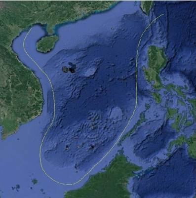
Figure
1 Map of
the East Indies delineates the SCS U-boundary
|
indicates
the national boundary delimitation in the SCS in 1948. The map clearly
indicates China??s territorial sovereignty over the SCS Islands and is
historical evidence of China??s territorial sovereignty and maritime rights and
interests in the SCS.
In this
study, a digitized dataset of the SCS U-boundary delineated on the Map of East
Indies published by the Ya Kwang Geographical Institute in 1948 was obtained
(Figure 1). The geographical names on the Map of East Indies were compared with
those on five other maps of the SCS Islands published in the same period,
thereby obtaining the Dataset of Geographical Names of Islands from Six Maps
Covering the SCS Published from the 1940s to the 1950s.
Our results
show that the following maps of the same origin
in the delineation of China??s territory in the South China Sea: the Map of East
Indies (published in January 1948), the Location Map of the SCS Islands
contained in A Brief Account of the
Geography of the SCS Islands (published in November 1947), the Location
Map of the SCS Islands contained in the Map
of the Administrative Districts of the Republic of China (produced in December
1947 and published in February 1948). The only difference is that China??s
maritime boundary in the SCS is delineated on the Map of East Indies using the
solid-line national boundary symbol. These two datasets have important
implications for the investigation of the national boundary delimitation and
evolution in the SCS and will serve as basic data and important evidence for
research into the SCS problem.
Author Contributions
Li, J. M.
formulated the overall design for the data development and collected and
treated the data of the SCS U-boundary (1948). Luo, Y. extracted some of the
names of the SCS Islands on the maps. Liu, S. H. and Zhang, W. Z. performed
data verification. Li, J. M., Zhang, W. Z., Liu, S. H., and Luo, Y. co-authored
the paper.
Conflicts of Interest
The authors declare no conflicts of interest.
References
[1]
Government of the People??s
Republic of China. Statement of the Government of the People??s Republic of
China on China??s Territorial Sovereignty and Maritime Rights and Interests in the
South China Sea [N]. People??s Daily, 2016-7-13(1).
[2]
Tang, D. L., Liu, Y. P., Hao,
X. G., et al. A newly-discovered
historical map using both national boundary and administrative line to
represent the U-boundary in the South China Sea [J]. Chinese Science Bulletin, 2018, 63(9): 856?C864.
[3]
Guanghua Geographical
Institute. New Map of the People??s Republic of China [M]. Shanghai: SDX Joint
Publishing, 1950.
[4]
Liu, Y. P., Tang, D. L., Wu, C.
X., et al. Zoning of the U-boundary
in the South China Sea and its ecological environment characteristics [J]. Haiyang Xuebao, 2019, 41(2): 14?C30.
[5]
Luo, Y., Li, J. M., Zhang, W.
Z., et al. A historical map of East
Indies representing the U-boundary in the South China Sea as an international
boundary [J]. Chinese Science Bulletin,
2019, 64(23): 2390?C2394.
[6]
King,
L. W., King, L. H. Map of East Indies [M]. Shanghai: Ya Kwang Geographical
Institute, 1948.
[7]
Zhang, Y. G., Liu, K., Liu, G.
C. The evolvement of the state maritime boundary in South China Sea by maps: China??s
nine-dotted maritime boundary line in South China Sea [J]. Scientia Geographica Sinica, 2012, 32(9): 1033?C1040.
[8]
Tang, M., Ma, J. S., Wang, Y., et al. Spatial demarcation principles of
the dotted line in the South China Sea [J]. Acta
Geographica Sinica, 2016, 71: 914?C927.
[9]
Wang, Y., Ge, C. D., Zou, X. Q.
Evidence of China??s sea boundary in the South China Sea [J]. Acta Oceanol Sinica, 2017, 36: 1?C12.
[10]
Fu, J. J., Zheng, Z. Y. A Brief
Account of the Geography of the South China Sea Islands [M]. Shanghai: The
Commercial Press, 1947.
[11]
Fu, J. J. Map of the
Administrative Districts of the Republic of China [M]. Shanghai: The Commercial
Press, 1948.
[12]
King, C. Y. New Map of China by
Province [M]. Shanghai: Ya Kwang Geographical Institute, 1948.
[13]
Li, J. M., Zhang, W. Z., Liu,
S. H., et al. Dataset of the South
China Sea U-boundary based on the map of East Indies published by Ya Kwang
Geographical Institute in 1948 [J/DB/OL]. Digital
Journal of Global Change Data Repository, 2021. https://doi.org/10.3974/geodb.2021.08.07.V1.
https://cstr.escience.org.cn/
CSTR:20146.11.2021.08.07.V1.
[14]
Li,
J. M., Zhang, W. Z., Liu, S. H., et al.
Dataset of geographical names of islands from six maps covering South China Sea
published from 1940s to 1950s[J/DB/OL]. Digital
Journal of Global Change Data Repository, 2021. https://doi.org/10.3974/geodb.2021.09.06.V1.
https://cstr.escience.org.cn/CSTR:20146.11.2021.09.06.V1.
[15]
GCdataPR Editorial Office.
GCdataPR data sharing policy [OL]. https://doi.org/10.3974/dp.policy.2014.05
(Updated 2017).
[16]
The State Council of the
People??s Republic of China. China Committee on Geographical Names was
authorized to publish standard geographical names for part of Nanhai Zhudao [J].
Gazette of the State Council of the
People??s Republic of China,
1983(10): 452-463.