Global Change Data Encyclopedia
Babuyan Islands, the Philippines
Liu, C.* Shi, R. X. Zhu, Y. Q
Institute of Geographic Sciences and Natural Resources Research, Chinese Academy of Sciences, Beijing 100101, China
Key Words: Babuyan Islands; volcano; the Philippines; Pacific Ocean; data encyclopedia
|
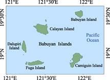
Figure 1 Map of Babuyan Islands dataset (ArcGIS .shp format)
|
The Babuyan Islands is located at the Pacific Ocean, between Babuyan Chanel and Balintang Chanel. It belongs to the Cagayan Valley Region of the Babuyan Province of the Philippines. Its geo-locations is from 19°34′26″N to 18°48′44″N and from 121°11′44″E to 121°59′41″E[1]. The Babuyan Islands are separated by Balintang Channel from the Balingtang Islands 45.6 km at its northeast, by Babuyan Channel from Luzon Island 28 km (from Fuga Island to Luzon Island) at its south (Figure 1, Figure 2).
|
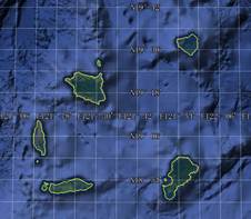
Figure 2 Map of Babuyan Islands dataset (Google Earth .kmz format)
|
The Babuyan Islands includes 5 big islands, Babuyan Island, Calayan Island, Camiguin Island, Fuga Island, and Dalupiri Island. A series of small islands are also included, which are Panuitan Island, Mabag Islan, Barit Island, Pamoctan Island,Irao Island and Pinon Island[2–4]. Among the islands, the Calayan Island is the biggest one, and its area is 196.34 km2. The Camiguin Island lies with the longest coastline 76.95 km. The total area of the Babuyan Islands is 613.40 km2, and the total coastline is 324.77 km (Table 1). The Babuyan Island and the Camiguin Island are located at the Luzon Volcanic Arc. The Babuyan Claro Volcano is located at 19°31′22.96″N, 121°56′29.70″E and Smith Volcano at 19°32′20.81″N, 121°54′50.28″E are located at the Babuyan Island; and the Camiguin de Babuyanes volcano is located at 18°49′56.40″N, 121°51′45.34″E is located at the Camiguin Island.
Table 1 List of main islands in the Babuyan Islands (area and coastline)
|
Name of islands
|
Geo-location
|
Area (km2)
|
Coastline (km)
|
|
Calayan Island
|
19º14′39″N-19º23′39″N, 121º20′47″E-121º32′33″E
|
196.34
|
74.53
|
|
Camiguin Island
|
18º48′44″N-19º0′14″N, 121º49′34″E-121º59′37″E
|
170.45
|
76.95
|
|
Fuga Island
|
18º50′21″N-18º54′22″N, 121º16′28″E-121º29′2″E
|
96.86
|
53.10
|
|
Babuyan Island
|
19º28′31″N-19º34′26″N, 121º53′34″E-121º59′41″E
|
73.53
|
42.82
|
|
Dalupiri Island
|
19º0′46″N-19º10′20″N, 121º11′44″E-121º15′16″E
|
66.15
|
43.82
|
|
Barit Island
|
18º51′10″N-18º52′33″N, 121º14′30″E-121º15′52″E
|
4.79
|
8.01
|
|
Panuitan Island
|
19º25′23″N-19º27′8″N, 121º30′14″E-121º31′6″E
|
2.87
|
7.97
|
|
Mabag Island
|
18º52′39″N-18º53′21″N, 121º15′3″E-121º16′12″E
|
1.07
|
5.73
|
|
Pamoctan Island
|
18º53′46″N-18º54′29″N, 121º49′47″E-121º50′22″E
|
0.91
|
3.82
|
|
Irao Island
|
18º58′49″N-18º59′17″N, 121º12′49″E-121º13′11″E
|
0.32
|
2.52
|
|
Pinon Island
|
18º52′22″N-18º52′40″N, 121º49′18″E-121º49′28″E
|
0.08
|
1.40
|
|
Others
|
|
0.03
|
4.10
|
|
Babuyan Islands
|
18°48′44″N-19°34′26″N, 121°11′44″E-121°59′41″E
|
613.40
|
324.77
|
The dataset was developed based on the Google Earth and related maps and references[5–6]. The dataset is consisted of 15 data files and archived in the .kmz and .shp data formats with the data size of 3.44 MB (Compressed to 1.35 MB in two data files).
References
[1] Liu, C., Shi, R. X., Zhu, Y. Q. Boundary data of the Babuyan Islands [DB/OL]. Global Change Research Data Publishing & Repository, 2016. DOI:10.3974/geodb.2016.04.02.V1.
[2] Babuyan Islands [OL]. https://en.wikipedia.org/wiki/Babuyan_Islands.
[3] Li, A. Q. World Map·Asia: the Philippines [M]. Beijing: Sino Maps Press, 2014.
[4] Editorial Office of Global Geographical Names. Chinese-Foreign Language Handbook of Global Geographical Names [M]. Beijing: Sino Maps Press, 1999.
Data Computing Environment
[5] ESRI. ArcGIS campus license of Institute of Geographical Sciences and Natural Resources Research, Chinese Academy of Sciences, Beijing, China.
[6] Google LLC. Google Earth Pro. 7.3.2.5481 (32-bit), hk.google.com.
URL for Data Downloading
http://www.geodoi.ac.cn/WebEn/doi.aspx?Id=412.
Or search through: http://www.geodoi.ac.cn.