Isles of Scilly, United Kingdom
Zhang,
Y. H. Liu, C.*
Shi, R. X.
Institute of Geographic Sciences and Natural Resources
Research??Chinese Academy of Sciences, Beijing 100101,
China
Keywords: Isles
of Scilly; England; Cornwall; Data encyclopedia
|
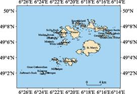
Figure
1 Map of
the Isles of Scilly dataset (.shp format)
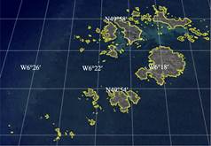
Figure
2 Map of
the Isles of Scilly dataset (.kmz format)
|
The Isles of Scilly, also called Scilly Isles, is lying southwest of
Cornwall, England, 40 to 58 km off Land??s End. It??s geo-location is 49??51??48??N?C49??58??
58??N, 6??26??45??W?C6??14??34??W[1-5]
(Figure 1, Figure 2).
There are 265 islands and
islets in the Isles of Scilly, but only five of the islands are inhabited-St
Mary's Island, Tresco Island, St Martin's Island, Bryher Island and St.
Agnes-Gugh Island. The Bryher Island (49??57??12??N, 6??21??22??W) is the smallest
inhabited island with area of 1.61 km2 and coastline length of 13.32
km. Bishop Rock (49??52??23??N, 6??26?? 44??W) with area of 2,447 m2 is
located at the Isles of Scilly??s western end with a notable Lighhouse of civil
engineering built in November, 1858[6]. The biggest island is the
StMary's Island with the area of 7.37 km2 and the coastline length
of 23.48 km. Other small islands include Samson, Annet, Tean, Great Ganilly,
St. Helen's, Great-Little Arthur, Ganinick, Gweal, White Island, Little
Ganilly, Round Island, Mincarlo, Menawethan, Great Innisvouls, Illiswilgig,
Rosevear, Little Innisvouls, Ragged Island, Castle Bryher and Maiden Bower[7]
(Table.1). The total area of the isles of Scilly is 20.58 km² and the total
coastline length is 162.66 km.
Table
1 Geolocation, area and coastline of
main islands of the Scilly Isles
|
Name of island
|
Geolocation
|
Center of Island
|
Area (m2)
|
Coastline (km)
|
|
St. Mary's
|
49??54??10??N-49??56??17??N,
6??19??45??W-6??16??31??W
|
49??55??15??N,
6??17??55??W
|
7365960
|
23476
|
|
Tresco
|
49??56??21??N-49??58??5??N,
6??21??8??W-6??19??9??W
|
49??57??16??N,
6??20??3??W
|
3136360
|
11190
|
|
St. Martin's
|
49??57??21??N-49??58??54??N,
6??18??18??W-6??15??38??W
|
49??57??39??N,
6??16??58??W
|
2888700
|
16043
|
|
St. Agnes-Gugh
|
49??52??56??N-49??53??56??N,
6??21??26??W-6??19??30??W
|
49??53??31??N,
6??20??29??W
|
1989340
|
13276
|
|
Bryher
|
49??56??31??N-49??58??2??N,
6??21??57??W-6??20??51??W
|
49??57??12??N,
6??21??22??W
|
1608100
|
13320
|
|
Samson
|
49??55??36??N-49??56??21??N,
6??21??31??W-6??20??49??W
|
49??55??57??N,
6??21??9??W
|
531777
|
4636
|
|
Annet
|
49??53??26??N-49??54??1??N,
6??22??45??W-6??21??54??W
|
49??53??44??N,
6??22??18??W
|
392502
|
5103
|
|
Tean
|
49??57??50??N-49??58??21??N,
6??19??8??W-6??18??25??W
|
49??58??6??N,
6??18??45??W
|
363245
|
5096
|
|
Great Ganilly
|
49??56??54??N-49??57??21??N,
6??15??53??W-6??15??4??W
|
49??57??7??N,
6??15??28??W
|
272425
|
3210
|
|
St. Helen's
|
49??58??11??N-49??58??32??N,
6??19??49??W-6??19??12??W
|
49??58??21??N,
6??19??31??W
|
270415
|
2353
|
|
Great-Little Arthur
|
49??56??31??N-49??56??53??N,
6??16??5??W-6??15??42??W
|
49??56??37??N,
6??15??53??W
|
171140
|
2457
|
|
Ganinick
|
49??56??35??N-49??56??51??N,
6??16??48??W-6??16??22??W
|
49??56??43??N,
6??16??34??W
|
143017
|
2165
|
|
Gweal
|
49??57??5??N-49??57??22??N,
6??22??19??W-6??22??3??W
|
49??57??13??N,
6??22??10??W
|
97597
|
1629
|
|
White Island
|
49??55??47??N-49??55??59??N,
6??21??57??W-6??21??36??W
|
49??55??53??N,
6??21??45??W
|
63201
|
1289
|
|
Little Ganilly
|
49??56??53??N-49??57??1??N,
6??16??16??W-6??15??60??W
|
49??56??57??N,
6??16??8??W
|
62084
|
958
|
|
Melledgan
|
49??52??25??N-49??52??38??N,
6??22??17??W-6??22??4??W
|
49??52??31??N,
6??22??11??W
|
53455
|
1317
|
|
Round Island
|
49??58??38??N-49??58??49??N,
6??19??29??W-6??19??16??W
|
49??58??44??N,
6??19??22??W
|
52594
|
1135
|
|
Mincarlo
|
49??55??56??N-49??56??8??N,
6??23??16??W-6??23??3??W
|
49??56??3??N,
6??23??10??W
|
52192
|
1132
|
|
Menawethan
|
49??56??39??N-49??56??47??N,
6??14??55??W-6??14??39??W
|
49??56??43??N,
6??14??46??W
|
45864
|
1065
|
|
Great Innisvouls
|
49??56??54??N-49??57??2??N,
6??15??1??W-6??14??49??W
|
49??56??58??N,
6??14??55??W
|
41595
|
812
|
|
Illiswilgig
|
49??56??29??N-49??56??37??N,
6??22??58??W-6??22??40??W
|
49??56??33??N,
6??22??49??W
|
40287
|
1156
|
|
Scilly Rock
|
49??57??21??N-49??57??29??N,
6??22??52??W-6??22??41??W
|
49??57??25??N,
6??22??46??W
|
31839
|
1030
|
|
Rosevear
|
49??52??9??N-49??52??16??N,
6??24??11??W-6??23??58??W
|
49??52??13??N,
6??24??4??W
|
31265
|
767
|
|
Little Innisvouls
|
49??56??59??N-49??57??4??N,
6??14??52??W-6??14??39??W
|
49??57??1??N,
6??14??46??W
|
25716
|
787
|
|
Gorregan
|
49??52??1??N-49??52??8??N,
6??23??23??W-6??23??13??W
|
49??52??4??N,
6??23??18??W
|
23802
|
732
|
|
Ragged Island
|
49??56??44??N-49??56??50??N,
6??15??37??W-6??15??25??W
|
49??56??47??N,
6??15??31??W
|
21543
|
669
|
|
Seal Rock
|
49??56??32??N-49??56??41??N,
6??23??13??W-6??23??6??W
|
49??56??37??N,
6??23??9??W
|
19586
|
765
|
|
Castle Bryher
|
49??56??35??N-49??56??40??N,
6??22??27??W-6??22??18??W
|
49??56??37??N,
6??22??24??W
|
16871
|
618
|
(To
be continued on the next page)
(Continued)
|
Name of island
|
Geolocation
|
Center of Island
|
Area (m2)
|
Coastline (km)
|
|
Great Crebawethan
|
49??52??41??N-49??52??49??N,
6??24??47??W-6??24??40??W
|
49??52??45??N,
6??24??43??W
|
16175
|
602
|
|
Maiden Bower
|
49??56??45??N-49??56??52??N,
6??23??36??W-6??23??30??W
|
49??56??49??N,
6??23??33??W
|
13878
|
522
|
|
Daisy
|
49??51??53??N-49??51??56??N,
6??24??2??W-6??23??57??W
|
49??51??54??N,
6??23??59??W
|
7402
|
320
|
|
Zantman's Rock
|
49??52??5??N-49??52??8??N,
6??26??33??W-6??26??27??W
|
49??52??7??N,
6??26??30??W
|
5450
|
359
|
|
Bishop Rock
|
49??52??22??N-49??52??24??N,
6??26??45??W-6??26??42??W
|
49??52??23??N,
6??26??44??W
|
2447
|
246
|
|
Little Crebawethan
|
49??52??42??N-49??52??43??N,
6??25??4??W-6??25??3??W
|
49??52??43??N,
6??25??3??W
|
705
|
102
|
The dataset was developed based on the
Google Earth and related maps and references[3,4].
The dataset is consisted of 15 data files and archived in the .kmz and .shp
data formats with the data size of 395 MB (Compressed to 163 MB in two files).
References
[1]
Isles of Scilly [OL]. Encyclopedia
Britannica, Encyclopedia Britannica Inc., 16 Aug., 2019. https://www. britannica.com/place/Isles-of-Scilly-islands-England-United-Kingdom.
[2]
World Map Atlas: United Kingdom
Atlas [M]. Beijing: Sino Maps Press, 2007.
[3]
Liu, C., Shi, R. X., Zhang, Y.
H., et al. Global multiple scale
shorelines dataset based on Google Earth images (2015) [DB/OL]. Global Change
Research Data Publishing & Repository, 2019. DOI:
10.3974/geodb.2019.04.13.V1.
[4]
Liu, C., Zhang, Y. H., Shi, R.
X., et al. British Isles [DB/OL]. Global
Change Research Data Publishing & Repository, 2019.
DOI:10.3974/geodb.2019.05.06.V1.
[5]
Liu, C., Zhang, Y. H., Shi, R.
X., et al. British Isles [J]. Journal of Global Change Data &
Discovery, 2019, 2019, 3(3): 209?C302.
[6]
Liu, C.,
Shi, R. X. Isles of Scilly[DB/OL].
Global Change Research Data Publishing & Repository, 2016.
DOI:10.3974/geodb.2016.09.07.V1.
[7]
Bishop Rock Lighthouse [OL].
Encyclopedia Britannica, Encyclopedia Britannica Inc., 14 Oct., 2011.
https://www.britannica.com/topic/Bishop-Rock-Lighthouse.
Data Computing Environment
[8]
ESRI. ArcGIS campus license of
Institute of Geographical Sciences and Natural Resources Research, Chinese
Academy of Sciences, Beijing, China.
URL
for Data Downloading
http://www.geodoi.ac.cn/WebCn/doi.aspx?Id=617.
Or search through: http://www.geodoi.ac.cn.