Global Change Data Encyclopedia
Ogasawara Archipelago, Japan
Liu, C.1* Chen, W. B.2,3 Shi, R. X.1
1. Institute of Geographical Sciences and Natural Resources Research, Chinese Academy of Sciences, Beijing 100101, China;
2. Keio Research Institute at SFC, Keio University, Fujisawa 2520882, Japan;
3. Nature & Science Consulting Co. Ltd., Yokohama 2310032, Japan
Keywords: Ogasawara Archipelago; Bonin Islands; volcano; Japan; Pacific Ocean; data encyclopedia
The Ogasawara Archipelago is located in the Philippine Sea, Northwestern Pacific Ocean. It is part of the Volcano Islands Arc of North Pacific Ocean and 394 km from north to south. It is 351 km from the Tori-shima of Izu Islands at its north, and 538 km from the Farallón de Pájaros of Mariana Islands at its south. Its geo-location is 20°25′22″N-27°43′31″N, 136°3′55″E-153°59′11″E[1].
|
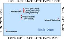
Figure 1 Geo-location of Ogasawara Archipelago (ArcGIS .shp format)
|
The Ogasawara Archipelago is consisted of Ogasawara Islands (or Bonin Islands), Volcano Islands (or Iwo Islands), Nishinoshima, Minami-Tori-shima and Okinotorishima. The Bonin Islands is consisted of three island groups, Muko-jima Group, Chichi-jima Group, and Haha-jima Group. The Volcano Islands is consisted of Kita Iwo Jima, Iwo Jima, and Minami Iwo Jima (Figure 1). The most recent volcanic eruption in Nishinoshima occurred in 2013 and till to early 2014 (Figure 2). The total area of the Ogasawara Archipelago is 106.60 km2, and its total coastline is 376.27 km. The islands groups and three remote small islands of the Ogasawara Archipelago are listed in Table 1.
The Muko-jima Group is located in northern of the Ogasawara Archipelago, and its geo-location is 27º29′3″N-27º43′31″N, 142º5′36″E-142º13′11″E. It is consisted of Muko-jima, Nakadachi-jima, Yome-jima, Kita-no-jima, Torishima, and Mae-jima. The Muko-jima, Nakadachi-jima, Yome-jima, and Kita-no-jima are on the list of UNESCO World Heritages. The total area of the Muko-jima Group is 5.20 km2, and the total coastline is 60.75 km (Table 2).
|

Figure 2 Volcanic eruption in Nishinoshima (Google Earth Image, Feb. 2014)
|
Table 1 List of island groups and three remote islands of the Ogasawara Archipelago
|
Name of islands
|
Name of the
island group
|
Geo-location
|
Area
(km2)
|
Coastline
(km)
|
|
Ogasawara Is.
(Bonin Is.)
|
Muko-jima Group
|
27º29′3″N-27º43′31″N,
142º5′36″E-142º13′11″E
|
5.20
|
60.75
|
|
Chichi-jima Group
|
27º1′47″N-27º11′57″N,
142º9′41″E-142º14′58″E
|
38.34
|
130.33
|
|
Haha-jima Group
|
26º32′23″N-26º43′2″N,
142º7′11″E-142º14′33″E
|
25.99
|
129.49
|
|
Volcano Is.
(Iwo Is.)
|
Volcano Islands (Iwo Islands)
|
24º13′29″N-25º26′56″N,
141º16′19″E-141º28′23″E
|
34.82
|
44.01
|
|
|
Nishinoshima
|
27º14′21″N-27º15′7″N,
140º52′22″E-140º52′57″E
|
0.78
|
5.05
|
|
|
Minami-Tori-shima
|
24º16′52″N-24º17′52″N,
153º58′15″E-153º59′11″E
|
1.46
|
5.58
|
|
|
Okinotorishima
|
20º25′22″N-20º25′33″N,
136º3′55″E-136º4′53″E
|
0.01
|
1.05
|
|
Total
|
|
|
106.60
|
376.27
|
Note: The area and coastline include those from main islands and its surrounding small islands or rocks.
Table 2 Geo-location, area and length of coastline of each island in Muko-jima Group
|
Name of island
|
Geo-location of
the main island
|
Central location of the main island
|
Area (km2)
|
Coastline (km)
|
|
Muko-jima
|
27º40′12″N-27º41′22″N,
142º7′25″E-142º8′58″E
|
27º40′44″N,
142º8′35″E
|
2.71
|
21.86
|
|
Nakadachi-jima
|
27º37′11″N-27º38′8″N,
142º10′12″E-142º11′15″E
|
27º37′42″N,
142º10′43″E,
|
1.35
|
12.63
|
|
Yome-jima
|
27º29′19″N-27º30′8″N,
142º12′11″E-142º12′58″E
|
27º29′51″N,
142º12′35″E
|
0.69
|
8.89
|
|
Kita-no-jima
|
27º42′54″N-27º43′14″N,
142º5′47″E-142º6′11″E
|
27º43′5″N,
142º5′60″E
|
0.29
|
13.58
|
|
Torishima
|
27º40′40″N-27º40′54″N,
142º7′24″E-142º7′37″E
|
27º40′47″N,
142º7′32″E
|
0.08
|
1.54
|
|
Mae-jima
|
27º29′11″N-27º29′22″N,
142º12′17″E-142º12′32″E
|
27º29′15″N,
142º12′28″E
|
0.08
|
2.25
|
|
|
|
|
5.20
|
60.75
|
Note: The area and coastline include those from main islands and its surrounding small islands or rocks.
The Chichi-jima Group[3] is located between the Muko-jima Group and Haha-jima Group of the Ogasawara Archipelago, and its geo-location is 27º1′47″N-27º11′57″N, 142º9′41″E-142º14′58″E. It is consisted of Chichi-jima, Ani-jima, Ot??to-jima, Nishi-jima, Minami-jima, Higashi-jima, Mago-jima, Hyoutan-jima, and Hitomaru Shima. In which, the Chichi-jima, Ani-jima, Ot??to-jima, Nishi-jima, Minami-jima, and Higashi-jima are on the list of UNESCO World Heritages. The total area of the Chichi-jima Group is 38.34 km2, and the total coastline is 130.33 km (Table 3).
Table 3 Geo-location, area and length of coastline of each island in Chichi-jima Group
|
Name of island
|
Geo-location of
the main island
|
Central location of
the main island
|
Area (km2)
|
Coastline (km)
|
|
Chichi-jima
|
27º2′9″N-27º6′22″N,
142º10′54″E-142º14′16″E
|
27º4′12″N,
142º12′33″E
|
23.82
|
59.63
|
|
Ani-jima
|
27º6′30″N-27º8′39″N,
142º11′12″E-142º14′15″E
|
27º7′20″N,
142º12′35″E
|
7.92
|
27.48
|
|
Ot??to-jima
|
27º8′40″N-27º11′25″N,
142º10′48″E-142º12′8″E
|
27º9′60″N,
142º11′27″E
|
5.24
|
20.87
|
|
Nishi-jima
|
27º6′46″N-27º7′18″N,
142º9′41″E-142º10′20″E
|
27º7′2″N,
142º10′0″E
|
0.49
|
5.12
|
|
Minami-jima
|
27º1′55″N-27º2′43″N,
142º10′18″E-142º10′41″E
|
27º2′18″N,
142º10′30″E
|
0.33
|
8.16
|
|
Higashi-jima
|
27º5′25″N-27º5′45″N,
142º14′26″E-142º14′58″E
|
27º5′36″N,
142º14′43″E
|
0.27
|
3.01
|
|
Mago-jima
|
27º11′34″N-27º11′49″N,
142º11′37″E-142º11′55″E
|
27º11′42″N,
142º11′45″E
|
0.14
|
2.48
|
|
Hyoutan-jima
|
27º7′36″N-27º7′46″N,
142º10′36″E-142º10′55″E
|
27º7′41″N,
142º10′45″E
|
0.08
|
2.38
|
|
Hitomaru Shima
|
27º6′57″N-27º7′8″N,
142º11′3″E-142º11′19″E
|
27º7′2″N,
142º11′10″E
|
0.06
|
1.21
|
|
|
|
|
38.34
|
130.33
|
Note: The area and coastline include those from main islands and its surrounding small islands or rocks.
The Haha-jima Group[4] is located between the Chichi-jima Group and Volcano Islands (Iwo Islands) of the Ogasawara Archipelago, and its geo-location is 26º32′23″N-26º43′2″N, 142º7′11″E-142º14′33″E. It is consisted of Haha-jima, Muk??-jima, Ane-jima, Im??to-jima, Mei-jima, Hirashima, Futako-jima, Katsuotorishima, and Marushima. The total area of the Haha-jima Group is 25.99 km2, and the total coastline is 129.49 km (Table 4).
The Volcano Islands (Iwo Islands) is located at the most south of Ogasawara Archipelago, and its geo-location is 24º13′29″N-25º26′56″N, 141º16′19″E-141º28′23″E. It is consisted of Kita Iwo Jima, Iwo Jima, and Minami Iwo Jima. The total area of the Volcano Islands (Iwo Islands) is 34.82 km2, and the total coastline is 44.01 km (Table 5).
Table 4 Geo-location, area and length of coastline of each island in Haha-jima Group
|
Name of island
|
Geo-location of
the main island
|
Center location of the main island
|
Area (km2)
|
Coastline (km)
|
|
Haha-jima
|
26º36′27″N-26º42′52″N,
142º7′19″E-142º11′21″E
|
26º40′2″N,
142º9′20″E
|
20.18
|
75.63
|
|
Muk??-jima
|
26º35′42″N-26º36′44″N,
142º7′22″E-142º8′9″E
|
26º36′12″N,
142º7′46″E
|
1.44
|
8.89
|
|
Ane-jima
|
26º32′35″N-26º33′54″N,
142º9′1″E-142º9′41″E
|
26º33′15″N,
142º9′23″E
|
1.50
|
13.05
|
|
Im??to-jima
|
26º33′11″N-26º33′52″N,
142º12′6″E-142º13′6″E
|
26º33′33″N,
142º12′35″E
|
1.29
|
9.50
|
|
|
Mei-jima
|
26º33′49″N-26º34′31″N,
142º13′33″E-142º14′26″E
|
26º34′10″N,
142º13′54″E
|
0.91
|
7.74
|
|
|
Hirashima
|
26º34′55″N-26º35′19″N,
142º8′50″E-142º9′44″E
|
26º35′10″N??
142º9′17″E
|
0.48
|
7.57
|
|
|
Futako-jima
|
26º35′20″N-26º35′35″N,
142º9′47″E-142º9′59″E
|
26º35′32″N,
142º9′50″E
|
0.08
|
2.85
|
|
|
Katsuotorishima
|
26º36′6″N-26º36′20″N,
142º10′32″E-142º10′44″E
|
26º36′13″N,
142º10′38″E
|
0.08
|
3.28
|
|
|
Marushima
|
26º35′36″N-26º35′45″N,
142º10′3″E-142º10′8″E
|
26º35′40″N,
142º10′6″E
|
0.03
|
0.97
|
|
|
|
|
|
25.99
|
129.49
|
|
| |
|
|
|
|
|
|
|
Note: The area and coastline include those from main islands and its surrounding small islands or rocks.
Table 5 Geo-location, area and length of coastline of each island in Volcano Islands (Iwo Islands)
|
Name of island
|
Geo-location of
the main island
|
Center location of the main island
|
Area (km2)
|
Coastline (km)
|
|
Kita Iwo Jima
|
25º25′7″N-25º26′56″N,
141º16′19″E-141º17′37″E
|
25º25′59″N, 141º16′57″E
|
5.56
|
9.05
|
|
Iwo Jima
|
24 º44′44″N-24º48′48″N,
141º17′6″E-141º20′54″E
|
24º46′58″N, 141º18′57″E
|
25.72
|
27.04
|
|
Minami Iwo Jima
|
24º13′29″N-24º14′42″N,
141º27′12″E-141º28′23″E
|
24º14′6″N, 141º27′45″E
|
3.54
|
7.92
|
|
|
|
|
34.82
|
44.01
|
Note: The area and coastline include those from main islands and its surrounding small islands or rocks.
The dataset includes spatial data, attribute data as well as the annotations for the islands in both Chinese and English, it is developed based on Google Earth imagery integrated with thematic maps[2–5]. The dataset is consisted of 15 data files and archived in both .shp[6] and .kmz[7] data formats with the data size of 4.62 MB, these data files are compressed into 2 data files with the data size of 1.74 MB.
References
[1] Liu, C., Chen, W. B., Shi, R. X. Ogasawara Archipelago [DB/OL]. Global Change Research Data Publishing & Repository, 2016. DOI: 10.3974/geodb.2016.09.18.V1.
[2] Bonin Islands [OL]. https://en.wikipedia.org/wiki/Bonin_Islands.
[3] Chichijima [OL]. https://en.wikipedia.org/wiki/Chichijima.
[4] Hahajima [OL]. https://en.wikipedia.org/wiki/Hahajima.
[5] Editorial Group of Handbook of Global Geographical Names. Handbook of Global Geographical Names [M]. Beijing: SinoMaps Press, 1999.
Data Computing Environment
[6] ESRI. ArcGIS campus license of the Institute of Geographic Science and Natural Resources Research, Chinese Academy of Science.
[7] Google LLC. Google Earth Pro. 7.3.2.5481 (32-bit), hk.google.com
URL for Data Downloading
http://www.geodoi.ac.cn/WebEn/doi.aspx?Id=628.
Or search through: http://www.geodoi.ac.cn.