The Vegetation Coverage Datasets Covering Ten Interconnection Projects of the Belt and Road Initiative (2017)
Tian, H. F.1,2 Niu, Z.1,2* Liu, Q. H.1 Wu, M. Q.1 Fu, D. M.3 Li, L.1 Wu, J. J.1 Pei, J.1,2 Gong, W.1,2 Cheng, L.3 Zhong, B.1
1. The State Key Laboratory of Remote Sensing Science, Institute of Remote Sensing and Digital Earth, Chinese Academy of Sciences, Beijing 100101, China;
2. College of Resources and Environment, Chinese Academy of Sciences, Beijing 100049, China;
3. School of Land Science and Technology, China University of Geosciences (Beijing), Beijing 100083, China
Abstract: In the background of the Belt and Road Initiative, influences of key interconnection infrastructure projects invested or constructed by China on local environment have attracted wide attentions from the international society. In this study, 10 key interconnection projects were chosen. Vegetation coverage dataset in the buffer zone of 10 km along these 10 projects was produced by the remote-sensing technical means and Landsat-8 remote-sensing image. This dataset used Landsat-8 Operational Land Imager (OLI) optical images as basic data. Firstly, the normalized difference vegetation index (NDVI) was calculated on the Google Earth Engine. Secondly, the annual maximum NDVI of the study area in 2017 was composited. Based on this annual maximum NDVI, the vegetation coverage dataset was calculated by the pixel binary model method. The fraction of vegetation coverage (FVC) ranged between 0 and 1, where 0 represented no vegetation coverage. Higher numerical values implied the better vegetation coverage. The spatial resolution of this dataset was 30 m and the dataset was archived in .tif format. It is consisted of 30 files, with a data size of 7.5 GB (compressed to 10 files, 516 MB). This dataset can provide objective and scientific basic data for relevant studies concerning influences of engineering construction on local vegetation ecosystems.
Keywords: fraction of vegetation coverage; the Belt and Road; interconnection project; Landsat image; Google Earth Engine
1 Introduction
Vegetation is one of important components of the ecosystem. It plays a very important role in substance circulation and energy exchange in the continental layer. Fraction of vegetation coverage (FVC) refers to the percentage of vertical projection area of vegetation (including leaves, braches and stems) on the horizontal ground in the total study
area[1–2]. FVC not only is an important parameter representing vegetation coverage on the Earth, but also an important parameter reflecting growth conditions of vegetation[3]. It is one of important indexes for remote-sensing measurement of vegetation degeneration[4]. Vegetation coverage is the collaborative consequence of multiple factors including regional climatic environment. Changes of vegetation coverage are of important significance to evaluate regional ecosystem[5]. Therefore, remote-sensing estimation of FVC becomes one of research hotspots at present.
In the background of the Belt and Road Initiative, some important interconnection infrastructure projects under the investment or construction of China achieved rapid development[6], which facilitated sustainable development of local social economy significantly[7]. However, influences of these projects on local complicated natural environment and ecological environment have attracted wide concerns from all sectors of the society[8–9]. Therefore, 10 key interconnection infrastructure projects under the financial aids or construction of China were chosen. A vegetation coverage dataset with a spatial resolution of 30 m in 10 km buffer zone along these 10 projects (hereinafter referred as FVC dataset 2017) was produced by the remote-sensing technical mean. It provides objective and scientific basic data to discuss influences of engineering construction on local vegetation ecosystem.
2 Metadata of Dataset
The metadata of the FVC dataset 2017[10–19] is summarized in Table 1. It includes the dataset full name, short name, authors, year of the dataset, temporal resolution, spatial resolution, data format, data size, data files, data publisher, and data sharing policy, etc.
Table 1 Metadata summary of the 10 projects along the area of the Belt and Road
|
Items
|
Description
|
|
Dataset name
(Full name;
Short name)
|
1. Fractional vegetation cover dataset within 10 km buffer area along Addis Ababa (Ethiopia)-Djibouti Railway (2017); FVC_Addis_Ababa-Djibouti_Railway_2017
2. Fractional vegetation cover dataset within 10 km buffer area along the Angren-Papu Railway in Uzbekistan (2017); FVC_Angren-Papu_Railway_2017
3. Fractional vegetation cover dataset within 10 km buffer area along Serenje-Chipata Railway, Zambia (2017); FVC_Serenje-Chipata Railway_2017
4. Fractional vegetation cover dataset within 10 km buffer area along Mombasa-Nairobi Railway, Kenya (2017); FVC_Addis_Ababa-Djibouti_Railway_2017
5. Fractional vegetation cover dataset within 10 km buffer area along Kosekoy-Inonu High Speed Railway, Turkey (2017); FVC_Kosekoy-Inonu_HSRailway_2017
6. Fractional vegetation cover dataset within 10 km buffer area along Hungary-Serbia Railway (Budapest- Belgrade) (2017); FVC_Hungary-Serbia_Railway_2017
7. Fractional vegetation cover dataset within 10 km buffer area along China-Laos-Thailand Railway (2017); FVC_China-Laos-Thailand_Railway_2017
8. Fractional vegetation cover dataset within 10 km buffer area along Peshawar-Karachi Motorway, Pakistan (2017); FVC_Peshawar-Karachi_Motorway_2017
9.Fractional vegetation cover dataset within 10 km buffer area along Moscow-Kazan High Speed Railway, Russia (2017); FVC_Moscow-Kazan_HSRailway_2017
10. Fractional vegetation cover dataset within 10 km buffer area along Djakarta-Bandung High Speed Railway, Indonesia (2017); FVC_Djakarta-Bandung_HSRailway_2017
|
|
Authors
|
Tian, H. F. A-3126-2019, Institute of Remote Sensing and Digital Earth, CAS, tianhf@radi.ac.cn
Niu, Z. M-9923-2017, Institute of Remote Sensing and Digital Earth, CAS, niuzheng@radi.ac.cn
Liu, Q. H. S-1647-2016, Institute of Remote Sensing and Digital Earth, CAS, liuqh@radi.ac.cn
Wu, M. Q. E-7890-2019, Institute of Remote Sensing and Digital Earth, CAS, wumq@radi.ac.cn
Fu, D. M. A-3414-2019, School of Land Science and Technology, China University of Geosciences (Beijing), 1994165106@qq.com
Li, L. S-4533-2016, Institute of Remote Sensing and Digital Earth, CAS, lili3982@radi.ac.cn
Wu, J. J. S-3712-2018, Institute of Remote Sensing and Digital Earth, CAS, wujj@radi.ac.cn
Pei, J. M-9240-2017, Institute of Remote Sensing and Digital Earth, CAS, peijie@radi.ac.cn
Gong, W. Q-8293-2017, Institute of Remote Sensing and Digital Earth, CAS, 1271129410@qq.com Cheng, L. A-3180-2019, School of Land Science and Technology, China University of Geosciences (Beijing), 441885013@qq.com
Zhong, B. L-4528-2016, Institute of Remote Sensing and Digital Earth, CAS, zhongbo@radi.ac.cn
|
|
Geographical region
|
Mombasa-Nairobi Railway (1°16′31″S–4°5′46″S, 36°48′35″E–39°41′41″E), Addis Ababa- Djibouti Railway (8°27′33″N–11°37′32″N, 38°30′52″E–43°10′22″E), Angren-Papu Railway (40°47′05″N–41°12′35″N, 70°1′24″E–71°10′51″E), Serenje-Chipata Railway (13°08′56″S– 14°24′19″S, 30°07′34″E–32°43′22″E), Hungary-Serbia Railway (44°44′17″N–47°27′01"N, 18°54′07″E–20°30′28″E), China-Laos-Thailand Railway (12°36′1″N–24°26′25″N, 100°25′29″E–103°2′56″E), Kosekoyo-Inonu Railway (39°44′49″N–40°50′52″N, 29°51′42″E– 30°29′38″E), Djakarta-Bandung Railway (6°9′23″S–7°4′6″S, 106°47′26″E–107°47′11″E), Moscow-Kazan Railway (55°39'25″N–56°28'4″N, 37°30'7″E–49°15'44″E), Peshawar-Karachi Road (24°51'50″N–34°13'29″N, 66°59'48″E–74°20'33″E)
|
|
Year
|
2017 Temporal resolution Year Spatial resolution 30 m
|
|
Data format
|
.tif Data size 516 MB (after compression)
|
|
Data files
|
FVC Dataset of Addis Ababa (Ethiopia) -Djibouti Railway (2017): 3 data files, 793 MB
FVC Dataset of Angren-Papu Railway in Uzbekistan (2017): 3 data files, 30 MB
FVC Dataset of Serenje-Chipata Railway, Zambia (2017): 3 data files, 178 MB
FVC Dataset of Mombasa-Nairobi Railway, Kenya (2017): 3 data files, 439 MB
FVC Dataset of Kosekoy-Inonu High Speed Railway, Turkey (2017): 3 data files, 41 MB
FVC Dataset of Hungary-Serbia Railway(Budapest- Belgrade) (2017): 3 data files, 243 MB
FVC Dataset of China-Laos-Thailand Railway (2017): 3 data files, 1.64 GB
FVC Dataset of Peshawar-Karachi Motorway, Pakistan (2017): 3 data files, 3.52 GB
|
|
Foundations
|
Chinese Academy of Sciences (XDA19030304); National Natural Science Foundation of China (41730107, 41771465)
|
|
Data publisher
|
Global Change Research Data Publishing & Repository, http://www.geodoi.ac.cn
|
|
Address
|
No. 11A, Datun Road, Chaoyang District, Beijing 100101, China
|
|
Data sharing policy
|
Data from the Global Change Research Data Publishing & Repository includes metadata, datasets (data products), and publications (in this case, in the Journal of Global Change Data & Discovery). Data sharing policy includes: (1) Data are openly available and can be free downloaded via the Internet; (2) End users are encouraged to use Data subject to citation; (3) Users, who are by definition also value-added service providers, are welcome to redistribute Data subject to written permission from the GCdataPR Editorial Office and the issuance of a Data redistribution license; and (4) If Data are used to compile new datasets, the ‘ten percent principal’ should be followed such that Data records utilized should not surpass 10% of the new dataset contents, while sources should be clearly noted in suitable places in the new dataset[20]
|
3 Methods
In the remote-sensing science field, FVC and normal different vegetation index (NDVI) are strongly correlated. NDVI is a common technical index for remote-sensing retrieval of FVC[21]. In this study, the retrieval formula of FVC is:

where NDVIsoil is the NDVI value in bare soil or non-vegetation regions. NDVIveg is the NDVI value of pure vegetation region. In the present study, a statistical analysis on NDVI values of all pixels in the study area was carried out. The NDVI value at 0.5% was taken as the NDVIsoil. Similarly, the NDVI value at 99.5% was viewed as NDVIveg.

where ρred and ρnir are reflectivities of the red band and near-infrared band in remote-sensing images, respectively.
Since each study area is large and there are generally cloudy and rainy weathers in the study area, the quality of remote-sensing images is influenced seriously. In the present study, disturbance of remote-sensing images by cloudy and rainy weathers was weakened by extracting and synthesizing the annual maximum NDVI value. In other words, there were many NDVI values on each pixel in one year. The maximum value was chosen as the value of the pixel. The maximum NDVI values at all pixels composed a new NDVI image, which was the NDVI data used in this study. On this basis, FVC was calculated according to the Equation (1).
4 Results and Validation
4.1 Data Composition
Compositions of datasets are shown in Table 1. The overall dataset covers 10 independent sub-datasets which are FVC datasets in the 10 km buffer zone along 10 interconnection infrastructure projects. Each sub-dataset had 3 files, including the master data file and header file: .tif, .tif.ovr, and .tif.aux.xml.
4.2 Data Products
FVC distributions in the 10 km buffer zone along the Mombasa-Nairobi Railway and Addis Ababa-Djibouti Railway in 2017 are shown in Figure 1. Limited by the article space, the FVC distributions along other projects are not exhibited here.
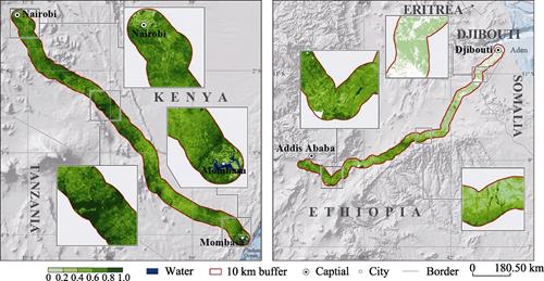
Figure 1 FVC distributions in the 10 km buffer zone along Mombasa-Nairobi Railway (left) and Addis Ababa-Djibouti Railway (right) in 2017
In a word, FVC along the selected projects generally ranged between 0.4 and 0.8 (Table 2). There’s regional difference in FVC distribution along all projects.
Table 2 Statistical results on FVC grading along different projects
|
Projects
|
|
FVC interval
|
|
0–0.2
|
0.2–0.4
|
0.4–0.6
|
0.6–0.8
|
0.8–1
|
|
Mombasa-Nairobi Railway
|
Area (km2)
|
85.98
|
955.94
|
4,063.78
|
3,539.3
|
904.8
|
|
Proportion (%)
|
0.9
|
10.01
|
42.55
|
37.06
|
9.48
|
|
Addis Ababa-Djibouti Railway
|
Area (km2)
|
4,741.95
|
3,350.5
|
4,020.38
|
1,354.84
|
49.8
|
|
Proportion (%)
|
35.08
|
24.79
|
29.74
|
10.02
|
0.37
|
|
Angren-Papu Railway
|
Area (km2)
|
488.24
|
311.48
|
284.52
|
286.42
|
293.62
|
|
Proportion (%)
|
29.34
|
18.72
|
17.1
|
17.21
|
17.64
|
|
Serenje-Chipata Railway
|
Area (km2)
|
5.72
|
6.31
|
206.35
|
3,339.28
|
2,883.52
|
|
Proportion (%)
|
0.09
|
0.1
|
3.2
|
51.84
|
44.77
|
|
Hungary-Serbia Railway
|
Area (km2)
|
74
|
203.7
|
875.4
|
2,784.7
|
3,793.4
|
|
Proportion (%)
|
0.96
|
2.63
|
11.32
|
36.02
|
49.07
|
|
China-Laos-Thailand Railway
|
Area (km2)
|
27.66
|
5,293.59
|
9,588.1
|
23,117.76
|
56.39
|
|
Proportion (%)
|
0.07
|
13.9
|
25.18
|
60.7
|
0.15
|
|
Djakarta-Bandung Railway
|
Area (km2)
|
653.12
|
57.25
|
419.5
|
546.6
|
951.85
|
|
Proportion (%)
|
24.85
|
2.18
|
15.96
|
20.79
|
36.22
|
|
Moscow-Kazan Railway
|
Area (km2)
|
410.63
|
1,193.36
|
2,773.01
|
18,274.54
|
5,738.85
|
|
Proportion (%)
|
1.45
|
4.2
|
9.77
|
64.37
|
20.21
|
|
Kosekoyo-Inonu Railway
|
Area (km2)
|
83.92
|
101.52
|
566.69
|
1,920.18
|
889.53
|
|
Proportion (%)
|
2.36
|
2.85
|
15.91
|
53.91
|
24.97
|
|
Peshawar-Karachi Road
|
Area (km2)
|
91.71
|
1,097.57
|
15,145.98
|
26,944.13
|
612.79
|
|
Proportion (%)
|
0.2
|
2.5
|
34.51
|
61.39
|
1.4
|
In the 10 km buffer zone along the Mombasa-Nairobi Railway, FVC was mainly between 0.4–0.6, which accounted for 42.55% of the total study area. The area of FVC between 0.6–0.8 was the second largest, which accounted for 37.06% of the total study area. FVC along the Mombasa-Nairobi Railway was generally uniform.
In the 10 km buffer zone along the Addis Ababa-Djibouti Railway, FVC was mainly between 0–0.2, which accounted for 35.08% of the total study area. The area of FVC between 0.4–0.6 accounted for 29.74% of the total study area. The vegetation coverage was generally low in the east, but high in the west along the Addis Ababa-Djibouti Railway. This was closely related with the local different climate types.
In the 10 km buffer zone along the Angren-Papu Railway, FVC was generally low. The area of FVC over 0.6 accounted for only 34.85% of the total study area, whereas the area of FVC below 0.4 was as high as 48.06%. The Angren-Papu Railway locates in the Eurasia where suffers serious droughts and a small annual precipitation.
In the 10 km buffer zone along the Serenje-Chipata Railway, FVC was mainly 0.4–0.6, which accounted for 43.34% of the total study area. The area of FVC between 0.6–0.8 was the second largest, which accounted for 40.27% of the total study area. The railway was in the southeast region of Africa. The humid climate is in favor of local vegetation growth.
In the 10 km buffer zone along the Hungary-Serbia Railway, FVC was mainly 0.4–0.6, which accounted for 42.50% of the total study area. The area of FVC between 0.6–0.8 was the second largest, which accounted for 25.50% of the total study area.
In the 10 km buffer zone along the China-Laos-Thailand Railway, the area of FVC between 0.4–0.6 was the largest (60.70%), followed by the area of FVC between 0.6–0.8 (25.18%).
In the 10 km buffer zone along the Djakarta-Bandung Railway, the area of FVC between 0.8–1 was the largest (951.85 km2, 36.22%), followed by the area of FVC between 0–0.2 (653.12 km2, 24.85%). There’s high vegetation coverage along the project, which is attributed to the hot and humid tropical rainy climate.
In the 10 km buffer zone along the Moscow-Kazan Railway, the area of FVC between 0.6–0.8 was the largest, which accounted for 64.37% of the total study area. The area of FVC over 0.8 was 20.21% of the total study area. There were small artificial disturbances and abundant forest resources. The area of FVC below 0.6 was 15.42%.
In the 10 km buffer zone along the Kosekoyo-Inonu Railway, the area of FVC between 0.8–1 accounted for 32.82% of the total study area. The areas of FVC in 0.6–0.8, 0.4–0.6, and below 0.4 were 29.52%, 22.92% and 14.73%, respectively.
In the 10 km buffer zone along the Peshawar-Karachi Road, the area of FVC between 0.6–0.8 was the largest (39.62%). There’s an extensive distribution of farmland along the Peshawar-Karachi Road and crops were the major vegetation.
5 Conclusion
Fraction of vegetation coverage is one of important indicators with ecological significance in the remote-sensing science field. It is significantly correlated with vegetation growth and biodiversity. In this study, FVC datasets in the 10 km buffer zone along 10 interconnection infrastructure projects in “the Belt and Road” region in 2017 were produced. FVC distributions along different projects were analyzed. Research conclusions provide objective and scientific basic data to study influences of engineering construction on local vegetation ecosystem. The international social concern to influences of engineering construction on local ecological environment was answered by objective data. This is beneficial to promote sustainable development of the Belt and Road Initiative.
Author Contributions
Tian, H. F., Niu, Z., Liu, Q. H., and Wu, M. Q. made the overall design of the dataset; Tian, H. F., Fu, D. M., Li, L., Wu, J. J., Pei, J., Gong, W., Cheng, L., and Zhong, B. collected and produced the FVC datasets; Tian, H. F. wrote the data paper.
References
[1] Hoffmann, W. A., Jackson, R. B. Vegetation-climate feedbacks in the conversion of tropical savanna to grassland [J]. Journal of Climate, 2000, 13(9):1593–1602.
[2] Gitelson, A. A., Kaufman, Y. J., Stark, R., et al. Novel algorithms for remote estimation of vegetation fraction [J]. Remote Sensing of Environment, 2002, 80(1): 76–87.
[3] Yan, X. X., Li, J., Yang, Z. Remote-sensing dynamic monitoring over temporal-spatial changes of vegetation coverage in Chenbaerhu Banner from 2000–2016 [J]. Journal of China Agricultural University, 2018, 23(6): 121–129.
[4] Peng, F., Fan, W., Xu, X., et al. Analysis on temporal-spatial change of vegetation coverage in Hulunbuir Steppe (2000–2014) [J]. Acta Scientiarum Naturalium Universitatis Pekinensis, 2017, 53(3): 563–572.
[5] Zhu, J. F., Xing, B. L., Jv, W. M., et al. Remote-sensing estimation of grassland vegetation coverage in Inner Mongolia, China [J]. Chinese Journal of Plant Ecology, 2011, 35(6): 615–622.
[6] Mayinuer, Zhao, J. Barriers against the “Walking Out” of China railway under the proposal of “One Belt, One Road” and countermeasures [J]. Practice in Foreign Economic Relations and Trade, 2018(9): 8–11.
[7] Mark, W., Deng, Z. Y. Driving effect of one railway [J]. China Investment, 2018(8): 86–90.
[8] Wang, L. Z., Zhang, Y. J. Strategic positioning and governing system of environmental protection problems in the view of “One Belt, One Road” [J]. Chinese Journal of Environmental Management, 2016(4): 60–64.
[9] Wang, H. H. Environmental protection problems in countries along the “One Belt, One Road” [J]. China’s Strategic Emerging Industries, 2018(40): 31–33.
[10] Tian, H. F., Niu, Z. Fractional vegetation cover dataset within 10 km buffer area along Addis Ababa (Ethiopia)-Djibouti Railway (2017) [DB/OL]. Global Change Research Data Publishing & Repository, 2018. DOI: 10.3974/geodb.2018.08.03.V1.
[11] Pei, J., Niu, Z., Wu, M. Q. Fractional vegetation cover dataset within 10 km buffer area along the Angren- Papu Railway in Uzbekistan (2017) [DB/OL]. Global Change Research Data Publishing & Repository, 2018. DOI: 10.3974/geodb.2018.07.07.V1.
[12] Fu, D. M., Niu, Z., Wu, M. Q. Fractional vegetation cover dataset within 10 km buffer area along Serenje- Chipata Railway, Zambia (2017) [DB/OL]. Global Change Research Data Publishing & Repository, 2018. DOI: 10.3974/geodb.2018.07.15.V1.
[13] Tian, H. F., Niu, Z. Fractional vegetation cover dataset within 10 km buffer area along Mombasa-Nairobi Railway, Kenya (2017) [DB/OL]. Global Change Research Data Publishing & Repository, 2018. DOI: 10.3974/geodb.2018.07.17.V1.
[14] Fu, D. M., Niu, Z., Wu, M. Q. Fractional vegetation cover dataset within 10 km buffer area along Kosekoy-Inonu High Speed Railway, Turkey (2017) [DB/OL]. Global Change Research Data Publishing & Repository, 2018. DOI: 10.3974/geodb.2018.07.18.V1.
[15] Fu, D. M., Niu, Z., Wu, M. Q. Fractional vegetation cover dataset within 10 km buffer area along Hungary- Serbia Railway (Budapest-Belgrade) (2017) [DB/OL]. Global Change Research Data Publishing & Repository, 2018. DOI: 10.3974/geodb.2018.07.19.V1.
[16] Wu, J. J., Liu, Q. H., Li, L., et al. Fractional vegetation cover dataset within 10 km buffer area along China- Laos-Thailand Railway (2017) [DB/OL]. Global Change Research Data Publishing & Repository, 2018. DOI: 10.3974/geodb.2018.07.20.V1.
[17] Gong, W., Liu, Q. H., Niu, Z. Fractional vegetation cover dataset within 10 km buffer area along Peshawar- Karachi Motorway, Pakistan (2017) [DB/OL]. Global Change Research Data Publishing & Repository, 2018. DOI: 10.3974/geodb.2018.07.08.V1.
[18] Cheng, L., Niu, Z., Wu, M. Q. Fractional vegetation cover dataset within 10 km buffer area along Moscow- Kazan High Speed Railway, Russia (2017) [DB/OL]. Global Change Research Data Publishing & Repository, 2018. DOI: 10.3974/geodb.2018.07.14.V1.
[19] Li, L., Liu, Q. H., Niu, Z., et al. Fractional vegetation cover dataset within 10 km buffer area along Djakarta- Bandung High Speed Railway, Indonesia (2017) [DB/OL]. Global Change Research Data Publishing & Repository, 2018. DOI: 10.3974/geodb.2018.08.01.V1.
[20] Editorial office of GCdataPR. GCdataPR data sharing policy [OL]. DOI: 10.3974/dp.policy.2014.05 (Updated 2017).
[21] Li, Q. X., Zhang, B., Wang, S., et al. Research on regional difference of vegetation coverage from 2000–2015 in Beijing-Tianjin source regions of sandstorms [J]. Earth Science Frontiers, 2018, 25(5): 298–304.