Earth Data Encyclopedia
Coastline Data of Nauru
Liu, C.* Shi, R. X. Zhu, Y. Q.
Institute of Geographic Sciences and Natural Resources Research, Chinese Academy of Sciences, Beijing 100101, China
Keywords: Nauru; coastline; island; geography of the world; data encyclopedia
|
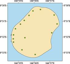
Figure 1 Map of Coastline Data of Nauru
|
Nauru island is located at the Center Pacific in northeast of Australia. Its figure looks like ellipse with full of phosphate reefs and rocks. It’s geographical location is from 0°33′18.40″S to 0°30′3.26″S, and from 166°57′35.19″E to 166°54′30.57″E. Based on the Google Earth images, the coastline of the Nauru Island has been developed. The longest of the island from north to south is 5.96 km, and the widest from east to west is 4.79 km. The total area of the island is 23.67 km2, the length of the coastline is 18.94 km. The Republic of Nauru was established in 1968. It is one of the smallest countries in the world (together with Vatican City and Monaco). Nauru is divided into 14 districts, including Aiwo, Anabar, Anetan, Anibare, Baitsi, Boe, Buada, Denigomodu, Ewa, Ijuw, Meneng, Nibok, Uaboe and Yaren. The pattern of the land ecosystems in Nauru Island is the near ellipse; the out sphere of the island is the intertidal belt with the coral reef coast mostly
below one meter above sea level and 40-200 m wide. After the intertidal belt, the sandy beach
follows. The most populated and settled places are located around the beach of the island. The center of the island is the terrace. Most of the places of the island are lower than 50 meters, the highest peak only 71 m. Nauru is the most sensitive area in the world, which is effective by the global climate change and sea level rising.