An
Innovative Solution on Geographical Indications for Environment &
Sustainability (GIES)
Liu, C.1* Gong, K.2,3 Liu, Y. H.4 Liao, X. H.1 Wang, Z. B.1 He, C. C.5,6 Luo, H.7 Zhou, X.8 Tong, Q. X.8 Min, Q. W.1 Wu, J. J.9 Gui, D. W.10 Chen, J.11 Wang, P. P.12 Lu, F.13 Zhou, L.14 Sun, Y. W.15
Yang, X.16 Li, J.17 Wang, X. Q.18 Tian, H.19 Zhang, G. Y.20 Chen, C. X.21 Guo, P.22 Liang, Y.23 Xu, G. C.22 Zhang, Z. X.24 Yu, X. Y.25 Zhang, X. D.26 Issa, A. M. 26 Song, X. F.1 Wang, Z. X.1 Fu, J. Y.1 Wang, Y. S.1 Zhu, X. G.27 Zhang, L. F.28 Zhu, Y. Q.1 Yu, B. H.1 Wang, G. Y.3 Lin, G.1 Dai, X.29 Lyv, Y. H.30
1. Institute of Geographic Sciences and Natural Resources
Research, Chinese Academy of Sciences, Beijing 100101, China; 2. World
Federation of Engineering Organizations (WFEO), Paris; 3. Nankai University,
Tianjin 300071, China; 4. Ministry of Science and Technology of the People??s
Republic of China, Beijing 100036, China; 5. Food and Agricultural Organization
of the United Nations, Rome, Italy; 6. Peking University, Beijing 100871, China;
7. China Centre for International Science and Technology Exchange, Beijing
100081, China; 8. Aerospace Information Research Institute, Chinese Academy of
Sciences, Beijing 100101, China; 9. Faculty of Geographical Science, Beijing
Normal University, Beijing 100875, China; 10. Xinjiang Institute of Ecology and
Geography, Chinese Academy of Sciences, Wulumuqi 830011, China; 11. National
Geomatics Center of China, Beijing 100830, China; 12. Panshi City Government in
Jilin Province, Panshi 132399, China; 13. Feng County Committee in Jiangsu
Province, Feng County 221700, China; 14. Publicity Department in Yucheng City
Shandong Province, Yucheng 251299, China; 15. Rural Agricultural Bureau of
Yanchi County in Ningxia Hui Autonomous Region, Yanchi 751500,China; 16. Rural
Agricultural Bureau of Suining city in Sichuan, Suining 629018, China; 17.
China Periodicals Association, Beijing 100005, China; 18. Bureau of Science
Communication Chinese Academy of Sciences, Beijing 100864, China; 19. Society
of Scientific and Technological Periodicals, Chinese Academy of Sciences,
Beijing 100190, China; 20. The Geographical Society of China, Beijing 100101,
China; 21. China Society of Natural Resources, Beijing 100101, China; 22. China
General Consulting & Investment Co., Ltd., Beijing 100161, China; 23. China
Aerospace Science and Industry Corporation Limited, Beijing 100048, China; 24.
Yucheng Venture Capital Group Co., Ltd., Yucheng 251299, China; 25. Qiyuan
Fishery Technology Co., Ltd., Beijing 100097, China; 26. Zhongguancun the Belt
and Road Industrial Promotion Association, Beijing 100190, China; 27. Tianhang
Create technology Co. Ltd., Beijing 100085, China; 28. Tianjin Hytech
Information Technology Co.Ltd., Tianjin 300392, China; 29. Qinghai Academy of
Social Science, Xining 810099, China; 30. Ecological Society of China, Beijing
100085, China
Abstract: Jointly organized by the
Institute of Geographic Sciences and Natural Resources Research, Chinese
Academy of Sciences, and the World Federation of Engineering Organizations, the
Forum on An Innovative Solution on Geographical Indications for Environment
& Sustainability (GIES) was convened at the 2021 China International Fair
for Trade in Services (CIFTIS). More than 80 experts from 30 organizations
participated the forum on site and more than a thousand of people joining
virtually. The participates focused on 6 key issues to emphasize the roles of
scientific communities, governments, private sectors, technology innovation,
education, scientific communications and civil societies. Representatives from
11 cases demonstrated the progress and experiences. A common understanding and
agreement was made to launch the Decade Initiative on Geographical Indications
for Environment & Sustainability 2021?C2030 (GIES). The partners agreed
to establish a best practices and cases network during the following 10 years.
All agreed that it was a critical issue in using big data and internet of
things technology to encourage cooperation and collaboration among the
multi-stakeholders, which could archive the United Nations 2030 Sustainable
Development Goals, especially Goal 1, Goal 2, Goal 14, Goal 15 and Goal 17.
Keywords: GIES; geographical indications; environment; sustainability; SDGs;
decade initiative; cases
DOI: https://doi.org/10.3974/geodp.
2021.03.03
CSTR: https://cstr.escience.org.cn/CSTR:20146.14.20146.14.2021.03.03
1 Introduction
Jointly
organized by the Institute of Geographic Sciences and Natural Resources
Research, Chinese Academy of Sciences, and the World Federation of Engineering
Organizations, the Forum on An Innovative Solution on Geographical Indications
for Environment & Sustainability (GIES) was convened at the 2021 China
International Fair for Trade in Services (CIFTIS). More than 80 experts from 30
organizations joined the forum in person at the China National Convention
Center, Beijing and more than a thousand of people joined virtually on 4th
September 2021 (Figure 1).
Besides IGSNRR/CAS
and WFEO, the co-sponsor organizations include the Big Data Working Committee
of Geographical Society of China (GSC), China Centre for International Science
and Technology Exchange, China Society of Natural Resources, Nankai University,
Qiyuan Fishery Technology Co., Ltd., Yucheng Venture Capital Group Co., Ltd.,
governments of Feng county in Jiangsu province, Panshi city in Jilin province,
etc.
|
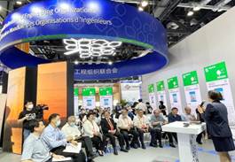
Figure 1 Co-organized by CIFTIS and WFEO,
the Forum was convened in the China National
Convention
Center, Beijing, on 4th September
|
Prof. Gong, K.,
President of WFEO, pointed out in his welcome speech at the forum that the aim
of WFEO to organize such a forum at CIFTIS is to highlight the role of
engineering innovation to archive the SDGs (Figure 2).
Prof. Liu, Y. H., former Vice Minister of
the Ministry of Science and Technology of China (MOST) and professor of
IGSNRR/
CAS, delivered the keynote
speech on Environment and Sustainability on Geogra-
phical Indications[1]
(Figure 3). The partici-
pants exchanged opinions on
how to
take action for SDGs and
discussed six
issues
focused on GIES. They were: opportunities and challenges for GIES; role of
science, technology and engineering in GIES; role of enterprises and private
sectors; role of scientific publications and communications; role of
government; the role of education and civilization culture, etc.
|

|
|
|
Figure 2 Prof. Gong, K., President of WFEO, made
a welcome address
|
Figure
3
Dr. Liu, Y. H., former Vice
Minister of the Ministry of Science and Technology, delivered a keynote
speech
|
|

|
|
|
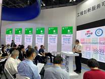
Figure
4 Forum on role of
government
|
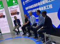
Figure
5 Forum on role of private
sectors
|
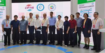
Figure 6
Group photo of
panels at the forum on roles of science, technology and engineers
2 Challenges and Solutions
2.1 Challenges
Environmental
protection and sustainable development are important parts of the UN
Sustainable Development Goals. For the geographical indications, keeping the
original geo-eco-bio-system and protecting the intellectual property are keys
for sustainable development. China is a country with the richest geographic
diversity in the world with its unique geographical civilizations. However,
most of the areas are with health environment, but low income in
socio-economics, and many have just been lifted out of poverty and are still at
risk of falling back into poverty. How to achieve environmental protection
while ensuring regional economic development is an important issue that needs
to be addressed immediately at present[3].
China carries
out international trade activities with more than 100 countries and regions in
the world[4], including quality geographical products in terms of
geographical indications, geographical specifications and geographical traditional
civilization products. In the international trade activities, health
environment and health geographical products are highly valued and strictly
regulated[5]. The China-EU Agreement on Geographical Indications[6]
has been implemented since March 1, 2021. Till July 5, 2021, in just a few
months, 110 products from China and 134 products from Europe entered the
markets of the other party, which was exceeding the expectations by both.
At present, the
protection of geographical indication products in China mainly lies in the
hands of intellectual property and the business communities. Although the
market trade has an urgent demand for the transparency of the information of
ecological natural products, relevant research in this regard is rather rare
and scarce, and geography research and service trade are not developed in a
coordinated way. Journals related to sustainable development have broken
through barriers among academic circles in science promotion, and effective
mechanisms for meeting the local needs are still being explored. The driving
force of independent and innovative technology application is not satisfactory
and there is a huge gap between system integration and social needs. This is a
comprehensive issue. It can be said that no single person or organization can
solve such problem. Therefore, promoting consistent cross-boundaries
communication and multi-stakeholders?? cooperation become a crucial mechanism.
2.2 The Innovative Solutions
In
driving health products, health environment and health life, especially in the
post-epidemic era, an implementable, operable and sustainable mechanism and
roadmap must be investigated, so that the protection of quality geographical
products and their intellectual property could finally go to sustainable
development. Thus, since January 2021, The Institute of Geographic Sciences and
Natural Resources Research, CAS, has held a series of seminars[7]
and show cases meetings[8] to discuss the integrated development
mechanism for GIES. In the 2021 China World Trade in Services Fair, institute
of Geographic Resources of CAS and United World Engineering Group, China
Association for Science and Technology and the United Nations Consultative
Committee on Information, Communication and Technology jointly launched the
GIES action plan. Multi-disciplinary integration, multi-participation system,
scientific implementation, technology and engineering implementation and
reliable science communication as important guarantees are well embodied.
Scientific communities work closed with local people, instead of focusing on
the publications?? impact factor[9] only. Scientific research should
help the local development and central policy designation, and optimize the
market, support the local sustainable development, upgrade the scientific
decision-making, boost the development and communication of interdisciplinary
sciences, and advance science popularization. Those best practices of diversity
and individuality following common geographical laws[10] are well
explanations of future earth.
The action plan,
mainly through comprehensive geographical science and technology and based on
the internet of things and big data systems, monitors the ecological
environment related to the geographical habitat and product development. As a
result, weather and disasters, air and soil and water conservation,
biodiversity and habitat resources, etc, are well monitored and recorded. By
utilizing information communication and data transmission technology,
environmental factors of natural ecology (wind speed, wind direction,
temperature, humidity, air pressure, light, rainfall, soil temperature, soil
moisture, PM2.5 and PM10, vegetation visible light,
vegetation, etc.) are measured and transmitted. Besides, with the help of
artificial intelligence, internet of things, cloud computing technology,
vegetation coverage, height and phonology could be automatically identified on
the cloud platform providing users with information support and services. In
this case, a safe, reliable and practical ??digital ecosystem?? can be
established. We should drive the logistics of natural ecology by digital data
and knowledge dissemination; boost tourism by quality research; foster a
mechanism of ecological environmental protection and sustainable development by
standardized management and traditions composed by culture. The mechanism is
made with science as the foundation, technology as the support,
multi-stakeholders as the main body, culture as the sediment, and
product?Corigin?Cbrand?Creputation?Cculture as a whole.
The innovative solution is to take
practices of habitat protection and sustainable develop-
ment
of quality geographical products as the starting point, achievement to SDGs,
create a new mechanism with open science as the core, and adopt the
implementation roadmap of multi-party participation, science empowerment,
technological innovation, communication guidance, property rights protection,
project accomplishment and people??s welfare.
2.3 Intellectual Property Protection and Science
Promotion Infrastructure
IGSNRR/CAS,
the largest institute on geography and natural resources in China and the
Global Change Scientific Research Data Publishing System (GCdataPR), a regular
member of the World Data System (WDS), become the important scientific and
technological strength in GIES program. In doing so, it resolves the major
public scientific and technological problems concerning holistic and long-term
development especially in the field of environment and resources. It also
consistently enhances the institute??s capacity for independent innovation and
sustainable development ability. Since the GCdataPR was officially launched in
June 2014[11], it becomes the China GEO Data Publishing Sub-center
approved by the National Remote Sensing Center of the Ministry of Science and
Technology and Regular member of WDS in 2016 and Data Publishing Sub-center of
National Data Center on Earth Observations. It was honored the awards,
including the WSIS Prize (e-Science,
Champion) 2018 and 2021[12], National Digital Publication Innovation
Project Award in 2018, and outstanding application award in big data for
research and education in 2017. The center provides services for the
registration of international digital objects[13] by DOI:10.3974 and
national digital objects by CSTR:20146 (China Science and Technology Resources)[14].
The special registration system[15] is composed of
DOI-CSTR-GCdataPR, guarantees the intellectual property protection for GIES
cases and products.
3 Show Cases
For
the GIES initiative, 11 cases were reported at the CIFTIS 2021, including 5
cases on best practices, 3 cases on the way of being evaluated, 2 cases for
instrument, equipment development and services and 1 case for investment
service.
3.1 Best Practices of Innovative Solution on
Geographical Indications for Environment & Sustainability
3.1.1 Evaluation
In
January 2021, a joint evaluation group for GIES organized by IGSNRR/CAS,
Geographical Society of China (GSC) and the Editorial Office of Journal of
Global Change Data, the World Data Center announced the specification for
evaluating GIES cases:
A. Fill the Case
Form for Evaluation
Cases that may
meet the following requirements:
(1) product
should be one at least among the three: geographical indication, geographical
specifications or geographical civilizations;
(2) product
should come from original geographical area;
(3) there are
companies join the case team;
(4) there are
scientists or experts on the products join the case team;
(5) any team
member has no record of bad faith or academic misconduct in the past three
years.
B. Peer Review
All of the cases
should go to peer review process. Normally, the process conducts three rounds
of reviewing and three rounds of checking[16] based on standards
according to the international publication rules and open science principles.
The contents reviewed are included for major pats: one is the physical
geo-eco-system scenario dataset, such as climate, soil, water, land forms, land
cover, bio-diversity, etc.; second one is the geographical indication product
data, such as variety, quality, ecological habits, growth state, nutrients, etc.;
the third one is the socio-economic and management data, such as
socio-economic, population, product management, as well as standards in product
management; and last one is the traditional or civilization information and
data. All of these data should be available to be published and openly
available to all. The Digital Journal of
Global Change Data Repository provides services for this.
Besides the
dataset, the knowledge about the product dataset should be clear and will be
available to be published and openly available to all. The Journal of Global Change Data & Discovery provides services for this.
C. Registration
After passing
the evaluation, relevant information will be officially registered, published
and widely disseminated in both Chinese and English. Each case that has passed
the review shall be issued with unique identification,
which also includes identification of scientific data, scientific knowledge
(article), geographical area and case specimen. In addition, labels of
observation instruments and equipment, research bases and germplasm resources
were added for cases with favorable conditions. These registrations are
completed through the World Data Center, GCdataPR[17].
D. Online Case
Network Services
The online
service system will be established for the GIES cases network. The case
information also with local monitoring system will be watched openly for all.
For cases of ecological degradation, environmental damage, falsification,
academic misconduct, etc., termination and cancellation will be required according
to relevant methods.
3.1.2 Yanchi Tan Sheep Arid Grassland
Case (Ningxia Hui Autonomous Region of China)
The
Yanchi Tan Sheep Arid Grassland Case is located at Huamaci township. The case
dataset was published at Digital Journal
of Global Change Data Repository with DOI:10. 3974/geodb.2021.05.09.V1 and
CSTR:20146.11.2021.05.09. The team members of the case study were from Ningxia
University, the Agricultural and Rural Bureau of Yanchi county, Ningxia Yanchi
Tan Sheep Industry, Village Committee of Wanjigou, Huamachi town, IGSNRR/CAS,
and Communication Department of Ningxia Hui autonomous region.
Yanchi county,
located in the northeast of Ningxia Hui autonomous region, is an arid grassland
area at the border of Shaanxi, Inner Mongolia and Ningxia. The annual average
temperature of Yanchi is 7.8 ??C, the
annual rainfall is 200?C240 mm, and the annual evaporation is 1,800?C2,400 mm,
which is about 10 times more of the annual precipitation. Yanchi is of typical
continental arid grassland climate. Groundwater in the region is generally
alkaline, with the pH ranges from 7.85 to 8.17. The main soil types of yanchi
soil are zonal limestone soil, non-zonal saline soil and aeolian sand soil.
There are four grassland types in Yanchi: steppe grassland, desert grassland,
sandy vegetation grassland and halophytic vegetation grassland. There are 175
species of natural plants, belonging to 39 families, most of which are forage
plants. Among them, 12 plants such as licorice and sophora alopecuroides are
included in pharmacopoeia, and 4 plants such as setaria are used as folk
medicines[18].
Tan Yanchi Tan
sheep is a geographical indication product, and Yanchi county is called as ??the
hometown of Tan sheep in China??. Yanchi Tan mutton, tan sheepskin and Tan ermao
fur are the main products of Yanchi Tan sheep. Yanchi Tan sheep is closely
related to people??s life and production for a long time. From breed
identification to dining table, Yanchi Tan sheep are regulated by a series of
standards (28 standards)[19]. Standardized management is an
important guarantee for breed protection, ecological and geographical
environmental protection, market credibility and herdsmen??s life and
well-being. Ningxia Yanchi Tan Sheep Industry Development Group Co., Ltd. is a
wholly state-owned enterprise established by Yanchi county people??s government
in 2017. It is an industrialization enterprise of Tan sheep that serves the
whole industry chain of Yanchi Tan sheep, integrating breed preservation,
purchase, processing, reserve, sales and promotion. At present, the company has
a slaughter plant of 300,000 Yanchi Tan sheep, and 5,000 Yanchi Tan sheep
ecological pasture. In 2006, it was listed in the protection species of
national livestock and poultry genetic resources by the Ministry of Agriculture.
In 2017, ??Ningxia Yanchi Tan Sheep Breeding System?? was selected as the fourth
batch of China??s important agricultural cultural heritage. When President Xi,
Jinping visited Ningxia in 2020, he instructed that ??The meat quality of Tan
sheep in Ningxia is good, and the tan sheep should have the characteristics of
Tan sheep. We should protect this breed.??.
3.1.3 Baoshan Arabica Coffee Dry-Hot
Valley Case (Yunnan Province of China)
The
Baoshan Coffee Xinzhai Village Dry-Hot Valley Case is located at Xinzhai village
of Baoshan county. The team members of the case study were from Baoshan
University, Meteorological Bureau of Longyang district, Baoshan Quality and
Technical Supervision Comprehensive Testing Center, Baoshan Chunzheng Coffee
Industry Co., Ltd., Coffee Association of Yunnan province and IGSNRR/CAS. The
case dataset was published at Digital
Journal of Global Change Data Repository with
DOI:10.3974/geodb.2021.05.10.V1 and CSTR:20146.11.2021.05.10.V1.
Coffee came to
Yunnan in around 1900s and began to be planted in large scale in Lujiang dam,
Xinzhai village of Baoshan prefecture after 1952. Baoshan Arabica coffee is
mainly planted in the dam area of Lujiang town, Longyang district, Baoshan
city. Xinzhai village is not only home to a large number of coffee gardens, but
also forms a vertical ecological zone with an altitude of 760 to 1,640 m, which
enables the cultivation of different coffee varieties. Over the years, Baoshan
coffee has formed a cultural and geographical tradition with regional
characteristics for the protection of dry and hot valley habitats and the
production and life of residents in Xinzhai village. Yunnan Baoshan Arabica
coffee, a national geographical indication product, is the only coffee
geographical indication product in China and one of the best coffee products in
the world. It has been granted the World Eureka Gold Award, USDA Certification
and China Agricultural Exhibition Silver Award, it also on the list of China-EU
Agreement on Geographical Indications in 2021[20].
3.1.4 Lanjia Rice Permanent Farmland
Case (Jilin Province of China)
The Lanjia Rice Permanent
Farmland Case is located at Panshi city of Jilin province of China. The team
members of the cast were from IGSNRR/CAS, Jilin University, Nanjing
Agricultural University, Agriculture and Rural Affairs Bureau of Panshi city,
Lanjia Rice Planting Cooperative, Beijing Tianhang Huachuang Technology Co.,
Ltd., and Beijing Machinery Industry Automation Research Institute Co., Ltd.
The case dataset was published at Digital Journal of Global Change Data
Repository with DOI:10.3974/geodb.2021.06.01.V1
and
CSTR:20146.11.2021.06.01.V1.
The Lanjia
village is located in the black land zone of transition area from Changbai
Mountains to Songnen Plain, with an altitude of 237?C384 m. Due to the
geographical location, natural precipitation, snow water and other clean water
sources, as well as the leaching of forest in Changbai Mountain and volcanic
basalt, the water quality of paddy fields in the village outperforms the urban
drinking water supply standard, and the soil is free from heavy metal
pollution. The good combination of air, water and soil and the integration of
traditional and modern management of paddy fields ensure the rice so high
quality. The rice variety is a middle-late maturing rice variety suitable for
Jilin area, with the transplanting time at 20?C26 May and the harvesting date at
around 10 October. The yield can reach 7,000‒7,500 kg/hm2[21].
3.1.5 Fengxian Burdock Ancient Yellow
River Flooding Case (Jiangsu Province of China)
The
Fengxian Burdock (Arctium lappa)
Ancient Yellow River Flooding Case is located at Fanlou town of Feng county.
The team members of the case study were from Agriculture and Rural Affair
Bureau of Feng county, Burdock Breeding Base, IGSNRR/CAS and Nature &
Science Consulting Co. Ltd. of Japan, and Xuzhou Kanghui Bainian Food Co., Ltd.
The case dataset was published at Digital
Journal of Global Change Data Repository registered with
DOI:10.3974/geodb.2021.06.06.V1 and CSTR:20146.11.2021.06.06.V1.
Fanlou town of
Feng county, located in the northwest of Jiangsu province, is the hometown of
LIU Bang, Emperor Gaozu of the Han Dynasty. Most of Feng county is an alluvial
plain formed by the ancient Yellow River??s repeated breach and flood
(historical records on Yellow River breaches and flooding from 420 to 1938 AD).
Burdock (Arctium lappa L.) is a
biennial herb belonging to Arctium lappa
L. in Compositae family. Its seed (Furctus
Arctii) is a traditional Chinese medicine, and its fleshy root has been
used as medicine and food. Feng county is known as the ??hometown of burdock?? in
China. Fanlou town, Fengxian county, lies in the plain of the Yellow River
flooded area, and has a tradition of planting deep-rooted crops such as burdock
in history. In 2013, Feng Burdock was designated as a National Geographical
Indication. The case states from the silt of the ancient Yellow River of
several meters to tens of meters thick in Feng county to the data and knowledge
of the growth and product sales of burdock, a special species in Fengxian
county, which reflects the Feng spirit that the people of Feng county
transformed a land suffering from the flooding of the Yellow River into a
beautiful and livable county, and further promote the burdock products produced
on this land[22].
3.1.6 Yangxian Black Rice Crested Ibis (Nipponia nippon) Habitat Case (Shaanxi
Province of China)
The
Yangxian Black Rice Crested Ibis (Nipponia
nippon) Habitat Case is located at Caoba village, Yang county. The
team members of the case study were from IGSNRR/CAS, Organic Industry
Development Office of Yang county, Zhuhuanhu Fruit Industry Professional
Cooperation, and Chang??an University. The case dataset was published at Digital Journal of Global Change Data
Repository with DOI:10.3974/geodb.2021.08.06.V1 and
CSTR:20146.11.2021.08.06.V1.
Caoba village,
Yangxian county is located at the southern foot of Qinling Mountains. In 1981,
only seven crested ibis birds were rediscovered in the paddy fields of Caoba
village, which were thought to be extinct. Since then, local villagers and
government began to protect the crested ibis and its habitat, and a new mode of
production based on a harmonious coexistence of human and crested ibis started
to evolve. Caoba village is the first place for the crested ibis to settle down
from high altitude to low altitude area, and it is also the core area for the
protection of the crested ibis. Black rice has been cultivated in Yangxian
county for more than 2,000 years. From the Han Dynasty to the Qing Dynasty, it
was offered to the court as tribute rice. Zhuhuanhu Fruit Industry Professional
Cooperative of Yang county is a cooperative organized by Caoba village to
produce and operate ??Zhuhuan Lake?? organic black rice. The planting base of
??Zhuhuan Lake?? organic black rice is located in the core area of the crested
ibis reserve where there is no pollution in the soil, atmosphere, water source
and surrounding environment. In the planting process, straws to be crushed and
returned to the field, organic fertilizer, farmyard manure, biogas slurry and
other organic fertilizers are adopted. Solar insecticidal lamps and plant-based
insecticide spraying are used in combination to kill insects, and a traditional
manual weeding method is applied. No fertilizer, pesticide, auxin, chemical
pigment and preservative are used in the whole production process, fostering a
pure natural and healthy food from nature. The atmospheric quality in the
reserve reaches Class I and the irrigation water reaches Class I?CII. Yang
county black rice and red rice were approved as national geographical
indication products respectively in 2006 and 2012[23].
3.2 GIES Cases in Preparation
There
are a number of cases on GIES in preparation. Three of the cases were
demonstrated at the Forum,
3.2.1 Yucheng Wheat and Maize Cropping
Farmland Case (Shandong Province of China)
A
joint team from Agricultural and Rural Affairs Bureau of Yucheng city, Shandong
Bailong Chuangyuan Bio-tech Co., Ltd., Futaste pharmaceutical Co., Ltd.,
Shandong Long live Bio-technology Co., Ltd., Yucheng Shenzhuang Nutritional Maize
Professional Cooperative, Wudeli Flour Group Yucheng Co., Ltd., Yucheng
Maixiangyuan Food Co., Ltd., Yucheng Yufei Flour Co., Ltd., Dezhou Jinshengyuan
Food Co., Ltd. and IGSNRR/CAS launched the Yucheng Wheat and Maize Cropping
Farmland Case study. Yucheng City has a long history. In the first year of
Tianbao of the Tang Dynasty (742 AD), Yucheng county was established, where
Dayu succeeded in flood control. Yucheng city is located in the north latitude
37??, with wheat cropping in winter and maize cropping in summer in one year as
the main farming mode. Thanks to the support of science and technology, Yucheng
city promotes the cultivation and protection model of basic farmland in the
Huang-huai-hai Area[24], which is resistant to water logging,
saline-alkali and sandstorm.
3.2.2 Kenli Hairy Crab Yellow River
Delta Wetland Case (Shandong Province of China)
IGSNRR/CAS
cooperated with Qiyuan Fishery Science and Technology Co., Ltd. to initial the
Kenli Hairy Crab Yellow River Delta Wetland Case study. Kenli district is
located near the Yellow River Delta of Dongying city, Shandong province. The
sediment carried by the Yellow River is pushed into the Bohai Bay at almost 3
km per year. A large area of shallow tidal flat and wetlands formed at the
confluence of the Haihe River and the Yellow River [25]. The water
can be classified into the weak alkaline water and contains a large amount of
nutrients. Water quality in the area is excellent and pollution-free, rich in
aquatic plants and bait. It is the main natural habitat of hairy crabs and the
source of artificial breeding of parent crabs in the Yellow River Estuary. The
Yellow River Estuary Crab (Eriocheir
Sinensis) is the most productive freshwater crab in China. In 2008, the
Ministry of Agriculture approved the Yellow River Estuary Crab as an
ago-product geographical indication.
3.2.3 Guanglu Island Sea Cucumber
Marine Case (Liaoning Province of China)
The
Sea Cucumber in Guanglu Island Marine environment in Changhai county is a
geographical indication. A team consisted of IGSNRR/CAS, Haisen Electronic Commerce
Co., Ltd., and Liaoning Normal University is working on the case study. The
Guanglu Island is located at 39??N and 122??E, near the intersection of the
Yellow Sea and the Bohai Sea. The sea cucumbers are residents with a water
depth of 15?C34 m in this area with biodiversities, including sea cucumbers,
cockles, shrimps, shellfish, fish, shrimps, crabs, algae and more local
precious specialties. Guanglu Island is called the ??hometown of sea cucumbers??,
accounting for about 50% of the total sea cucumber in China. The annual average
temperature of the sea water in the sea area is 12.1 ??C at the surface and 8.8 ??C at the
bottom. The optimum temperature for the growth of sea cucumber is 10?C18 ??C. The annual average salinity in the coastal area is 30 PSU. The most
suitable salinity for the growth of sea cucumbers is 27?C30 PSU, and the
salinity for survival is not more than 39 PSU and not less than 14 PSU. The
exchange and self-purification capacity of seawater are better than those of
other sea areas, and the nutrients are updated frequently. The turbulent
current also creates the unique elastic and compact taste characteristics of
Dalian sea cucumber[26].
3.3 Ecosystem Observation
Instruments and Equipment Development
There
is a need for the GIES case studies to have a ecosystem monitoring system. Two
systems were demoed at the Forum.
3.3.1 Ecological Observation Station
(Beijing, China)
The
Thinsitu 600 Ecological Observation Station system was developed and served by
Beijing Tianhang Huachuang Science and Technology Co., Ltd. It is a low-power
consumption IOT sensing device that provides vegetation monitoring,
meteorological monitoring, air quality monitoring, soil monitoring, water
quality monitoring and is equipped with other IOT sensing modules. Utilizing networking
and data transmission technology, real-time acquisition and wireless
transmission of wind speed, wind direction, air temperature, humidity, air
pressure, illumination, rainfall, soil temperature, soil moisture, PM2.5, PM10, vegetation
visible light and vegetation near-infrared image data are realized. Taking
advantage of artificial intelligence, internet of things and cloud computing
technology, the automatic identification of vegetation coverage, height and
phenology can be achieved in the cloud platform, featuring unattended
operation, solar power supply, lightweight design and convenient installation.
3.3.2 Buoy-Type Water Quality Spectral
Monitor System (Tianjin of China)
The
Buoy-Type Water Quality Spectral Monitor was developed and served by Tianjin
Progoo Information Technology Co., Ltd. It is an online intelligent system
integrating software and hardware for real-time comprehensive evaluation of
water quality. It takes water quality parameter spectral extraction technology
as the core and integrates sensor, intelligent control and network
communication technologies. It consists of a water quality intelligent monitor
(volume: 1 m??1.12 m??0.3 m) and a data analysis cloud service platform. The
monitor can collect data regularly at a fixed location and transmit it to the
cloud service platform in real time through the network to achieve 24-hour
continuous online monitoring. Data analysis cloud service platform for
different water quality models can be selected intelligently and water quality
parameters can be calculated quickly according to the requirements of water
body type and monitoring index. At present, it supports the monitoring of 15
common water quality indicators including water turbidity, pH, dissolved
oxygen, COD, ammonia nitrogen, TP, TN, permanganate index, chlorophyll, SS, TOC,
chroma, nitrite, BOD, comprehensive nutrition index and so on. Compared with
the laboratory test approach, the detection accuracy of single index can reach
95% at most, and the average is more than 85%. It can realize 24-hour
uninterrupted observation, and the data acquisition interval is flexible and
adjustable.
3.4 Investment Consulting Service for GIES
China
General Consulting & Investment Co. Ltd. demonstrated his experiences on
consultant services for GIES, especially in supporting digital trade technology
by satellite remote sensing, cold chain logistics, insurance services,
cross-border settlement, as well as the mechanism system (including a map of
material circulation, supply chain sharing and value compensation).
|
Figure 7 The GIES Logo
|
4 Launch of the Decade Initiative
on Geographical Indications for Environment & Sustainability 2021?C2030
(GIES)
After the
discussions, a common understanding was made on Joint Action of Launching of
the Decade Initiative on Geographical Indications for Environment &
Sustainability 2021?C2030 (GIES, Figure 7). The participants agreed to work
together for archiving to Goal 1, Goal 2, Goal 14, Goal 15 and Goal 17 of SDGs,
and should adhere to the integration of science, technology and engineering by
innovative solutions. More detail implementation plan will follow.
References
[1]
Liu,
Y. H. Action on quality geographical products for
environment and sustainability??keynote speech at GIES Forum of CIFTIS 2021 [J]. Journal of Global Change Data & Discovery, 2021, 5(3): 227?C229.
https://doi.org/10.3974/geodp.2021.03.01. https://cstr.escience.org.cn/ CSTR: 20146.14.2021.03.01.
[2]
Ge,
Q. S., Fang, C. L., Jiang, D. Geographical missions and coupling ways between
human and nature for the Beautiful China Initiative [J]. Acta Geographica Sinica, 2020, 75(6): 1109‒1119.
[3]
Li,
Z., Liu, Z. Y. The implementation and effects of mechanism of value realization
of ecological products [J]. China
Economic & Trade Herald,
2021(11): 41‒44.
[4]
National
Bureau of Statistics of China. 2021 China Statistical Yearbook [M]. Beijing:
China Statistics Press, 2021.09.
[5]
WIPO.
World Intellectual Property Indicators 2021 [Z]. Switzerland.
[6]
Notification
of Identification of European Union Geographical Indications Issued by China
National Intellectual Property Administration. The protection of first batch of
products in the agreement between European Union and the government of the
People??s Republic of China on geographical indications entered into force [J]. China Trademark, 2021(3): 25.
[7]
Liu,
C., Yu, X. H., Sun, Y. W., et al.
Summary report of the 1st Symposium on GI Environment and
Sustainability [J]. Journal of Global
Change Data & Discovery,
2021, 5(1): 108. https://doi.org/10.3974/geodp.2021.01.14.
https://cstr.escience.org.cn/CSTR:20146.14.2021.01.14.
[8]
Wang,
Z. X. Summary report of the 2nd Show Cases Symposium on GI
Environment and Sustainability [J].
Journal of Global Change Data &
Discovery, 2021, 5(1): 109. https://doi.org/10.3974/ geodp.2021.01.15.
https://cstr.escience.org.cn/CSTR:20146.14.2021.01.15.
[9]
Li,
J. Thoughts on the historical functions and shortcomings of the current
research evaluation mechanism in China [J]. Acta Editologica, 2021, 33(2): 119.
[10]
Fu,
B. J., Leng, S. Y., Song, C. Q. The characteristics and tasks of geography in
the new era [J]. Acta Geographica Sinica,
2015(8): 4‒10.
[11]
Liu,
C. Data publishing of global change in scientific research [J]. Acta Editologica, 2014, 69(Sup.): 4‒11.
[12]
Editorial
Office of Journal of Global Change Data
& Discovery. WSIS Prize 2018 (e-Science Champion) to the GCdataPR
Project [J]. Journal of Global Change
Data & Discovery, 2018, 2(1):
1‒6. https://doi.org/ 10.3974/geodp.2018.01.01.
https://cstr.escience.org.cn/CSTR:20146.14.2018.01.01.
[13]
ISO
26324: digital object identifier system [S]. 2012.
http://www.iso.org/iso/catalogue_detail.htm? csnumber=43506.
[14]
General
Administration of Quality Supervision, Inspection and Quarantine of the
People??s Republic of China, Standardization Administration of the P. R. C.
Science and technology resource identification: GB/T 32843??2016 [S]. Beijing:
Standards Press of China, 2016-8-29.
[15]
Liu,
C. Inauguration editorial of Digital
Journal of Global Change Data Repository [J]. Journal of Global Change Data & Discovery, 2020, 4(2): 101?C109.
https://doi.org/10.3974/geodp.2020.02.01. https:// cstr.escience.org.cn/CSTR:20146.14.2020.02.01.
[16]
Regulations
on the administration of publication. No.732 Decree of State Council of the
People??s Republic of China in 2020 [Z].
[17]
Editorial
Office of Journal of Global Change Data &
Discovery. Registration and code
specification of World Data Center of Global Change Research Data Publishing
& Repository [J]. Journal of Global
Change Data & Discovery,
2021, 5(3): 300?C311. https://doi.org/10.3974/geodp.2021.03.08. https://cstr. escience.org.cn/CSTR:20146.17.2021.03.08.
[18]
Zhang,
K. B., Li, R., Hou, R. P., et al.
Study on plant diversity of different control measures of desertification in
Yanchi county, Ningxia [J]. Science of
Soil and Water Conservation, 2004(4): 66?C72.
[19]
Zhang,
M. X., Sun, Y. W., Li, B., et al. Yanchi
Tan sheep Huamachi town arid grassland case dataset on ecosystem protection and
sustainable development [J/DB/OL]. Digital
Journal of Global Change Data Repository, 2021.
https://doi.org/10.3974/geodb.2021.05.09.V1.
https://cstr.escience.org.cn/CSTR:20146.
11.2021.05.09.V1.
[20]
Duan,
R. T., Liu, Y. T., Fu, C. L., et al.
Baoshan coffee Xinzhai village dry-hot valley case dataset on ecosystem
protection and sustainable development [J/DB/OL]. Digital Journal of Global Change Data Repository, 2021.
https://doi.org/10.3974/geodb.2021.05.10.V1. https://cstr.escience.org.cn/CSTR:20146.
11.2021.05.10.
V1.
[21]
Fu,
J. Y., Du, X. L., Zheng, Q. S., et al.
Panshi rice Lanjia village case dataset on permanent basic farmland protection and sustainable development [J/DB/OL]. Digital Journal of Global Change Data
Repository, 2021 https://doi.org/10.3974/geodb.2021.06.01.V1.
https://cstr.escience.org.cn/CSTR:20146.11.2021.06.01.V1.
[22]
Yao,
F. T., Chang, J. B., Zhao, C. Y., et al.
Fengxian burdock (Arctium lappa) ancient
Yellow River flooding area case dataset on habitat protection and sustainable
development [J/DB/OL]. Digital Journal
of Global Change Data Repository, 2021
https://doi.org/10.3974/geodb.2021.06.06.V1. https://cstr.escience.org.cn/
CSTR:20146.11.2021.06.06.V1.
[23]
Wang,
Y. S., Yang, Y. Y., Du, L. M., et al.
Dataset of GI environment protection and sustainable development of black rice
and crested ibis (Nipponia nippon)
habitat in Caoba village, Yang county, Shaanxi province of China [J/DB/OL]. Digital Journal of Global Change Data
Repository, 2021. https://doi.org/10.3974/geodb.2021.08.06.V1.
https://cstr.escience.org.cn/CSTR:20146.11.2021.08.06.V1.
[24]
Ouyang,
Z., Wu, L. F., Wang, C. J., et al.
Practice and experience for modern agricultural development mode with
resources-saving type at Yucheng city, Shandong province, China [J]. Bulletin of Chinese Academy of Sciences,
2011, 26(4): 383‒389.
[25]
Liu,
D. D., Wu, H. T., Lu, K. L., et al.
Effects of spatial and environmental factors on benthic invertebrate
communities in natural and freshwater restored wetlands of the Yellow River [J].
Acta Ecologica Sinica, 2021, 41(17):
6893‒6903.
[26] General Administration of Quality
Supervision, Inspection and Quarantine of the People??s Republic of China.
Geographical indication product Dalian sea cucumber (GB/T 20709?D2006) [S].
Beijing: Standards Press of China, 2006-12-11.