Classification
Index Dataset of Village Homestead Reuse in Jinghai District, Tianjin
Zhang, Y.1 Cai, W. M.2*
1. School of Economics and Management, Tiangong
University, Tianjin 300387, China;
2. School of Environmental Science and Engineering,
Tiangong University, Tianjin 300387, China
Abstract: Studying the types of
homestead reuse is of great significance to promoting the reform of the
homestead system. This dataset is an original dataset based on the statistical
data obtained from the Jinghai district Government??s thorough investigation of
56 homestead pilot villages, to construct a framework
for the analysis of the coupling characteristics of the ??village-land?? system,
and to establish a village identification index system and a homestead
utilization feature identification index system. The data is archived in .xlsx
and .shp formats, and consists of two data files, including the location of the
pilot villages, the villages of the pilot villages and the characteristics
indicators of the use of homesteads, etc. The data size is 614 KB (compressed
into one file of 480 KB).
Keywords: reuse of homestead; characteristics of the ??village-land?? system;
classification index; Jinghai district, Tianjin
DOI: https://doi.org/10.3974/geodp.2022.04.06
CSTR: https://cstr.escience.org.cn/CSTR:20146.14.2022.04.06
Dataset Availability Statement:
The dataset supporting this paper
was published and is accessible through the Digital Journal of Global Change
Data Repository at:
https://doi.org/10.3974/geodb.2022.06.07.V1 or https://cstr.escience.org.cn/CSTR:20146.11.2022.06.07.V1.
1 Introduction
Jinghai district is located
in the southwest of Tianjin city. It has 2 sub-districts, 18 townships, and 383
administrative villages under its jurisdiction, covering an area of 1,475.68 km2.
In 2020, Jinghai district was identified as one of the pilot districts for the
reform of the homestead system, and the pilot work of the homestead
investigation was carried out in two batches from 9th December 2020
to 4th February 2021. The investigation involved 18 townships, 56
villages and 20,000 households. Farmers?? rights and interests are the focus of
government officials at all levels and people from all walks of life in China.
For a long time, as the place of residence and important rights and interests
of farmers, homesteads have played an important role in safeguarding farmers??
livelihood and maintaining social stability. Therefore, the collection of
village and homestead data from the 56 pilot villages is of great significance
for the research on homestead and the reform of the homestead system, etc.
At present,
the research on homestead mainly focuses on the ??three rights of homestead??[1,2], the reform of the homestead
system[3,4] and the withdrawal of homestead[5,6], etc. There are few studies on the
reuse of homesteads. The author studies the selection of type of homestead
reuse based on this dataset and has published a paper in the Journal of Progress in Geography. In terms of research methods, most of the
studies use case studies[7,8]
and theoretical analysis[9], and less use of spatial quantitative
analysis. The reason for this is mainly due to the lack of spatial data of
homesteads from a micro perspective and the difficulty of obtaining, which
poses a huge obstacle to the development of micro-scale research.
In view of this, this dataset collects and collates
the village and homestead data of 56 pilot villages in Jinghai district,
Tianjin, and visualizes the data by using ArcGIS 10.8 software to achieve the
spatial analysis of the homestead. The dataset contains information on the
economy, ecology, culture, management, population, land and other aspects of
pilot villages, which is of great significance to the study of rural China.
2 Metadata of the Dataset
The metadata of the Indicators dataset of land use
transformation classification of villages-land system in Jinghai district,
Tianjin city of China[10] is
summarized in Table 1. It includes the dataset full name, short name, authors,
year of the dataset, data format, data size, data files, data publisher, and
data sharing policy, etc.
Table 1 Metadata summary of the Indicators
dataset of land use transformation classification of villages-land system in
Jinghai district, Tianjin city of China
|
Items
|
Description
|
|
Dataset full name
|
Indicators dataset of land use transformation classification of
villages-land system in Jinghai district, Tianjin city of China
|
|
Dataset short name
|
VillagesJinghai
|
|
Authors
|
Zhang, Y. GLN-4098-2022, School of Economics and Management, Tiangong
University, 15822580019@163.com
Cai, W. M. GLN-5852-2022, School of Environmental Science and
Engineering, Tiangong University, caiweimin@tiangong.edu.cn
|
|
Geographical region
|
Jinghai district, Tianjin
|
|
Year
|
2021
|
|
Data format
|
.xlsx, .shp
|
|
Data size
|
614 KB (compressed into 1 file of 480 KB)
|
|
Data files
|
The dataset consists of two parts:
(1) geographical distribution data of the 56 pilot villages in Jinghai
district, Tianjin (.shp)
(2) classification index data of village homestead reuse in Jinghai
district, Tianjin (.xlsx)
|
|
Foundations
|
National Natural Science Foundation of China (41801193)
|
|
Data computing environment
|
ArcGIS, Excel
|
|
Data publisher
|
Global Change Science
Research Data Publishing System http://www.geodoi.ac.cn
|
|
Address
|
No. A11, Datun Road, Chaoyang District, Beijing 100101, China
|
(To be continued on the next page)
(Continued)
|
Items
|
Description
|
|
Data sharing policy
|
Data from the Global Change
Research Data Publishing & Repository includes metadata, datasets
(in the Digital Journal of Global Change Data Repository), and
publications (in the Journal of Global Change Data & Discovery). Data sharing policy includes: (1) Data
are openly available and can be free downloaded via the Internet; (2) End
users are encouraged to use Data subject to citation; (3)
Users, who are by definition also value-added service providers, are welcome
to redistribute Data subject to written permission from the GCdataPR Editorial
Office and the issuance of a Data redistribution license; and (4)
If Data
are used to compile new datasets, the ??ten per cent principal?? should be
followed such that Data records utilized should not
surpass 10% of the new dataset contents, while sources should be clearly
noted in suitable places in the new dataset[11]
|
|
Communication and searchable
system
|
DOI, CSTR, Crossref, DCI,
CSCD, CNKI, SciEngine, WDS/ISC, GEOSS
|
3 Methods
3.1 Data Sources
All data in the
Homstead UtilizationCharacteristics Identification Index System are from the
homestead survey data published by the Tianjin Jinghai District People??s
Government, and the data sources of the village characteristics identification
index system are shown in the table.
Table 2 The source of the
data of the Village Characteristics Identification Index System
|
Dimensionality
|
Indicators
|
Data sources
|
|
|
Life A
|
Service completeness B1
|
POI data
(https://lbs.amap.com/)
|
|
|
Density of shopping service facility B2
|
|
|
Density of living service facility B3
|
|
|
Urbanization rate B4
|
Data from
homestead surveys published by Tianjin Jinghai district People??s Government
(http://www.tjjh.gov.cn)
|
|
|
Eco-C
|
Mean length of the river flowing through D1
|
Official
website of Jinghai district Government Water Affairs Bureau (http://www.tjjh.gov.cn/jhqzf/zwgk_28985/zfxxgk_qjjg1/swj1/fdzdgknr16/swjwj1/)
|
|
|
|
|
Hydrological regulation index D2
|
Official
website of Jinghai district Government Water Affairs Bureau (http://www.tjjh.gov.cn/jhqzf/zwgk_28985/zfxxgk_qjjg1/swj1/fdzdgknr16/swjwj1/)
|
|
|
Transport facility density D3
|
POI data
(https://lbs.amap.com/)
|
|
|
Degree of locational advantage D4
|
OpenStreetMap
(http://www.openhistoricalmap.org) Data
|
|
|
Country
Style E
|
Science, Education and Culture Service density F1
|
POI data
(https://lbs.amap.com/)
|
|
|
Negative information rate F2
|
Toutiao
(http://www.toutiao.com) Data Crawl
|
|
|
Village Features Resource Richness F3
|
Official
website of Jinghai district Government Culture and Tourism Bureau (http://www.tjjh.gov.cn/jhqzf/zwgk_28985/zfxxgk_qjjg1/wlj1/fdzdg
knr18/wljwj1/); Jinghai Statistical Yearbook 2020
|
|
|
Village Website Exposure F4
|
Toutiao
(http://www.toutiao.com) Data Crawl
|
|
|
Industry G
|
Enterprise density H1
|
POI data
(https://lbs.amap.com/)
|
|
|
Enterprise registered capital average H2
|
Tianyancha
(http://www.tianyancha.com) Public Data
|
|
|
Population density H3
|
Data from
homestead surveys published by Tianjin Jinghai district People??s Government
(http://www.tjjh.gov.cn)
|
|
|
Density of financial and insurance service facilities
H4
|
POI data
(https://lbs.amap.com/)
|
|
|
Management I
|
Proportion of
members of non- collective organizations J1
|
Data from
homestead surveys published by Tianjin Jinghai district People??s Government
(http://www.tjjh.gov.cn)
|
|
|
Homestead unique rate J2
|
|
|
Homestead approval rate J3
|
|
|
Density of government agencies and social groups J4
|
POI data
(https://lbs.amap.com/)
|
|
3.2 Data Processing
During the process of
data collection, collation and recording, a small number of data values were
missing. In order to ensure the integrity of the sample size, the missing data
values were filled. In the sample, of the missing data of the variable ??average
service life of homestead?? accounted for 1.8%, and the missing data of the
variable ??floor area ratio?? accounted for 5.4%. The proportion of missing data
was small and the indicators were all continuous numerical data[12], so the
mean interpolation method was used to fill in the missing values.
As the original
data of the pilot village homestead survey released by the government of
Jinghai district was conducted in two batches, and there were slight
differences in the data indicators collected by each village, this dataset was
used to collate and calculate the original data to obtain the required data
through the use of SPSS.26 software. The Jinghai district Homestead System
Reform Task Force Survey has accumulated abundant field data, which provides
data support for the analysis at the micro-scale.
The POI data was
obtained from the crawl of the Gaode Map API in 2021. ArcGIS 10.8 software was
used to crop the POI data, and was overlaid with the vector layer of the
Jinghai district. The spatial connectivity tool was applied to count the number
of different types of POIs in the 56 pilot villages. The POI classification
data used in this paper are all consistent with the POI classification code
officially announced by Gaode Map.
As a representative
of Internet information in the Web 3.0 era, ??Today??s Toutiao?? (means Today??s
Headline in Chinese) uses big data and algorithms to accurately distribute
information, and with the popularization of smartphones, it provides
convenience for small towns and rural populations to obtain information, and
meets the information needs of people with low education, low age and low income[13]. The Baidu index shows that
the search volume of ??Today??s Toutiao?? is much higher than that of the four
major news platforms, namely NetEase, Tencent, Sohu and Sina. Therefore, this
paper selects the website ??Today??s Toutiao?? as the source of village report
information data. First, with ??´´ village,
´´ town, Jinghai district, Tianjin?? as the search keyword, we searched
for the relevant reports of 56 pilot villages under the information column of
the ??Today??s Toutiao?? website, and captured the title, content profile and
source website of all the information. Secondly, considering that the greater
the number of reports on websites from different sources, the greater the
influence of the villages, so the information with the same content but from
different sources was not censored and included in the total amount of reports;
third, the influence of the villages will drive the influence of the townships
where they are located, i.e. the more villages are reported, the more the
number of reports in the townships where they are located. Therefore, the
content of the reports about the townships and the town government in the
search content has been censored. And invalid reporting content such as
villages or things with the same name in the non-study area were removed.
As a national
enterprise information inquiry network, Tianyancha mainly provides professional
enterprise information inquiry and enterprise relationship mining services. Its
website data comes from the National Enterprise Credit Information Publicity
System, China Judgment Documents Network, China Enforcement Information
Disclosure Network, State Intellectual Property Office, Trademark Office,
Copyright Office and other national authoritative websites[14]
. In this paper, by sorting and classifying the company enterprise data in the
POI data, we use Tianyancha to capture the registered capital data of each
company in order to screen the operating status of the company and reflect the
scale and volume of the enterprise, eliminating the enterprises whose business
address and operating status (revocation, cancellation, etc.) have changed, the
enterprises not found on Tianyancha, individual industrial and commercial households
(small in scale, which do not have a prominent impact on the industrial
dimension) and the enterprises that have not disclosed their registered
capital. Finally, 231 pieces of valid data were obtained.
3.3 Technical Route
In
order to study the type selection in the reuse of homestead, the data of
village characteristics and homestead utilization characteristics were
collected respectively, and the data were analyzed, collated and classified
with the help of Microsoft office Excel 2013 and ArcGIS 10.8 software (Figure
1). Firstly, based on the calculation results of the village characteristics
index system, the village characteristics identification model was used to
classify the pilot villages; secondly, based on the calculation results of the
homestead investigation data, the homestead utilization characteristics
identification model was used to classify the homestead in the unit of the
village. Finally, taking the ??village-land?? classification and the spatial
distribution into account, the type of homestead reuse was obtained.
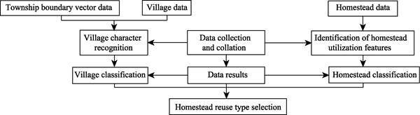
Figure1 Technology roadmap for dataset research and
development
4 Data Results
4.1 Data Composition
The dataset consists of two
parts: the geographical distribution data (.shp) of 56 pilot villages in
Jinghai district, Tianjin and the characteristic index data
(.xlsx) of villages and homestead utilization in Jinghai district, Tianjin.
Among them, the characteristic index data of villages and homestead utilization
includes the characteristic index scores of pilot villages for housing reform
and homestead utilization, the standardization and weight scores of village
classification indicators, the summary of village characteristics
identification index scores, the calculation scores of village classification
and identification models, village classification, homestead weight scores,
homestead utilization characteristic index contribution
score, the classification of homestead indicators, the summary of the index
scores of the larger contribution of homestead, the classification and summary
of different types of homestead and the classification and summary of the types
of reuse of homestead, etc.
4.2 Data Results
4.2.1 Village Feature Identification
The 56 villages in Jinghai district can be
divided into 3 categories: industry-led, resource- led and balanced development.
Resource-led and balanced development accounted for
42.86% and 41.07% respectively, and industry-led accounted for 16.07%,
indicating that at present, the proportion of rural development driven by
industrial is still relatively small. Among them, the industry-led type
includes nine villages, namely Sidangkouhou village, Manyizhuang village, Erjie
village, Yangxiaozhuang village, Yuan village, Xiaquan village, Shunmintun
village, Wangzhuangzi village and Zhongmingzhuang village; the resource-led
type includes 24 villages, i.e., Fengpu village, Huifengxi village, Wangjia
village, Dingjiafangzi village, Xigaozhuang village, Bapu village, Gongjiatun
village, Qiandeng village, Wangqianhu village, Zhongzhaizhuang village, Zengfutang
village, Lvguantun village, Gaoguantun village, Shiyipu village, Liujiafangzi village,
Donggang village, Mengzhuangzi village, Beierpu village, Liuxiangzhuang
village, Nanbatai village, Dongliumu village, Houxiaotun village, Linzhuangzi
village, Pulou village. The balanced development type includes 23 villages,
i.e., Beiwanying village, Wangkuang village, Tangshang village, quanli village,
Xuzhuangzi village, Dongzhai village, Nanwanying village, Xitantou village,
Lujia village, Houdeng village, Caizhuangzi village, Zengjiahe village,
Jiangjiachang village, Liuxiadao village, Liangxinzhuang village Luozhuangzi
village, Hanzhuangzi village, Dongfangzi village, Nanerpu village, Xiaohuangwa
village, Houmingzhuang village, Pan village, Shilipu village.
Figure 2 Distribution map of village types
4.2.2 Identification of
Homestead Utilization Features
The 56 villages in Jinghai district can be
divided into 2 categories: single-function- dominated homesteads and
multi-function-dominated homesteads. Single-function- dominated homesteads
accounted for 50%, including 28 villages, namely Linzhuangzi village,
Liangxinzhuang village, Liuxiadao village, Manyizhuang village, Lvguantun
village, Gaoguantun village, Yuan village, Pan village, Erjie village, Wangzhuangzi
village, Xiaquan village, Bapu village, Luozhuangzi village, Zengjiahe village,
Beiwanying village, Xigaozhuang village, Liujiafangzi village, Dingjiafangzi
village, Dongfangzi village, Liuxiangzhuang village, Huifengxi village,
Sidangkouhou village, Zengfutang village , Pulou village, Yangxiaozhuang
village, Zhongzhaizhuang village, Shunmintun village, Shilipu village,
indicating that the single-function-dominated homesteads are mostly distributed
along the canal and the southern part of Jinghai district. The main reason is
that the banks of the canal are protected areas and non-agricultural
construction activities are strictly controlled, resulting in the majority of
single-function-dominated homesteads in the villages along the canal. The
multi-function-dominated homesteads accounted for 50%, including 28 villages,
namely Wangqianhu village, Nanerpu village, Beierpu village, Nanwanying
village, Tangshang village, Wangjia village, Zhongmingzhuang village,
Houmingzhuang village, Donggang village, Xitantou village, Xiaohuangwa village,
Wangkuang village, Houxiaotun village, Shiyipu village, Nanbatai village,
Jiangjiachang village, Hanzhuangzi village, Caizhuangzi village, Xuzhuangzi
village, Houdeng village, Mengzhuangzi village, Dongliumu village, Fengpu
village, Lujia village, Gongjiatun village, Dongzhai village, Quanli village,
Qiandeng village, indicating that the multi-function-dominated homesteads are
mainly distributed in the west and northwest of Jinghai district. The main
reason is that the Ziya Economic and Technological
Development Zone and the Linhai Circular Economy Demonstration Zone are located
in the west and northwest of Jinghai district, covering most of the townships,
with a certain degree of radiation effect.
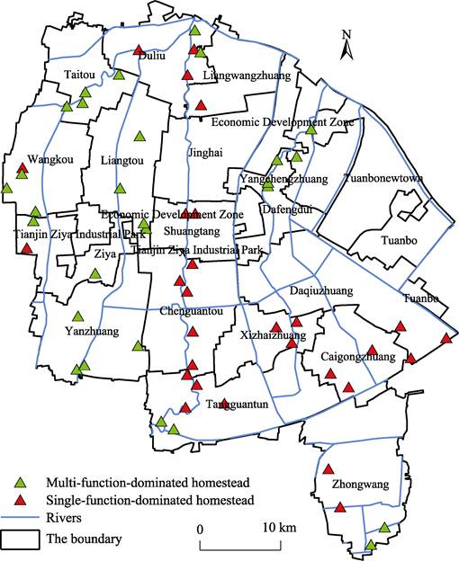
Figure 3 Distribution map of homestead types
4.2.3 Identification of
the Types of Homestead Reuse Based on the Characteristics of the ??village-land??
System
The types of homestead reuse
can be divided into three categories: multi-subject type, factor flow type and
characteristic resource type. The multi-subject type accounts for 28.57%,
including Zhongmingzhuang village, Wangkuang village, Tangshang village, Quanli
village, Xuzhuangzi village, Dongzhai village, Nanwanying village, Xitantou
village, Houdeng village, Lujia village, Caizhuangzi village, Jiangjiachang
village, Hanzhuangzi village, Nanerpu village, Xiaohuangwa village and
Houmingzhuang village. The multi-subject type villages are mainly distributed
in the western part of Jinghai district, indicationg that the market economy in
the western part of Jinghai district is well developed, and the multi-subject
type is high active. The use of multi-subject type to revitalize resources is
an important development direction for this category of villages; the factor
flow type accounts for 35.71%, including Wangqianhu village, Beierpu village,
Wangjia village, Donggang village, Houxiaotun village, Shiyipu village,
Nanbatai village, Mengzhuangzi village, Dongliumu village, Fengpu village,
Gongjiatun village, Qiandeng village, Sidangkouhou village, Manyizhuang
village, Erjie village, Yangxiaozhuang village, Yuan village, Xiaquan village,
Shunmintun village, Wangzhuangzi village, which are villages with factor flow
type. The 20 villages in this category are mainly distributed along the rivers
in Jinghai district, indicating that multi-branched rivers are a key
consideration for complementary villages to achieve factor flow, and making
full use of their own advantageous factors is an important development
direction for such category villages; the characteristic resource type accounts
for 35.71%, including 20 villages, namely Beiwanying village, Zengjiahe
village, Liuxiadao village, Liangxinzhuang village, Luozhuangzi village,
Dongfangzi village, Pan village, Shilipu village, Linzhuangzi village,
Lvguantun village, Gaoguantun village, Bapu village, Xigaozhuang village,
Liujiafangzi village, Dingjiafangzi village, Liuxiangzhuang village, Huifengxi
village, Zengfutang village, Pulou village and Zhongzhaizhuang village. The
characteristic resource type villages are mainly distributed in the lower
reaches of the South Canal and the southeast of Jinghai district, indicating
that the region has superior resource endowments and that making full use of
its own resources is an important development direction for such villages in
this category to achieve rural revitalization.

Figure 4 Distribution map of reuse types of homesteads
5 Discussion and Conclusion
The dataset
constructed in this study mainly collates and collects the data of the
classification indicators of village homestead reuse in Jinghai district,
Tianjin, from the perspective of ??village-land?? characteristics, and provides a
theoretical reference for solving the problems and obstacles related to
homestead reuse. Starting from solving practical problems, the dataset not only
provides a classification governance idea based on the rural scale, but also
proposes a feasible and operable classification governance scheme from the
perspective of homestead scale and homestead reuse. Compared with similar
studies, this dataset uses multi-source data and cross-scale research methods
to explore a feasible pathway to solve the practical issues, which is
innovative and replicable. It can also provide data support for the study on
rural settlements, homestead and rural revitalization in eastern China. The
disadvantage is that the selected indicators of this dataset are limited and
have a great correlation with the population, so attention should be paid to
regionality and timeliness in the process of data use.
Author Contributions
Zhang, Y. collected
and processed the data and wrote the data paper; Cai,
W. M. reviewed the data paper, etc.
Conflicts of Interest
The
authors declare no conflicts of interest.
References
[1]
Cui, J. F., Guo, G. C., Han, S., et al. A logical review of the
??separation of three rights?? in rural collective land and the form of its
realization [J]. China Land Science, 2022, 36(4): 8–15.
[2]
Chen, S. X. The ??three rights?? of rural residential
bases: problem orientation, logic and realization path [J]. Journal of
Nanjing Agricultural University (Social
Science Edition), 2022, 22(2): 147–158.
[3]
Chen, W. H., Lv, P. The innovative dynamics of
residential land system reform: dilemma and breakthrough: an analysis based on
two rounds of pilot studies [J]. Rural Economy, 2022(5): 30–39.
[4]
Qiu, L. ??Collectivization of land rights??: the logic
of reforming the residential base system in traditional farming areas [J]. Journal
of Northwest Agrarian and Forestry University of Science and Technology (Social Science Edition),
2022, 22(3): 82–89.
[5]
Wu, Y. L., Yu, Y. Y., Hong, J. G. Property rights
transfer, value realization and benefit sharing of residential land withdrawal:
a field survey based on Jinzhai and Yujiang [J]. China Rural Economy,2022(4):
42–63.
[6]
Yan, X., Li, L. T., Li, H. Did home base withdrawal
reduce farmers?? poverty vulnerability? —Evidence from Jinzhai, Anhui [J]. China
Land Science, 2022, 36(4):
38–48.
[7]
Wei, C. L., Zhong, X. H. Spatial reorganization:
integration of property rights and effective social governance of unused
farmhouses in the urban-rural interface: a case study of farmhouse reuse in
Shanghai [J]. China Rural Economy,
2022(4): 23–41.
[8]
Yang, L. L., Wang, H. H. A study of seven typical
pilot villages in two municipalities [J]. Journal of Northwestern University
(Philosophy and Social Science
Edition), 2022, 52(3): 63–79.
[9]
Wang, Y. The re-systematization of collective
construction land use rights in the context of ??three pieces of land?? reform
[J]. Yunnan Social Science, 2022(3):
137–149.
[10]
Indicators dataset of land use transformation
classification of villages-land system in Jinghai district,Tianjin
city of China [J/DB/OL]. Digital Journal
of Global Change Data Repository, 2022. https://doi.org/10.3974/geodb.2022.06.07.V1.
https://cstr.escience.org.cn/CSTR:20146.11.2022.06.07.V1.
[11]
GCdataPR Editorial Office. GCdataPR data sharing
policy [OL]. https://doi.org/10.3974/dp.policy.2014.05 (Updated 2017).
[12]
Li, J. L. Dynamic evaluation of micro and small
enterprises?? credit based on tax information [D]. Nanjing: Nanjing University
of Posts and Telecommunications, 2020.
[13]
Ouyang, R. H. From news portals to social media: the
changing business model and development path of portals [J]. News and Writing, 2019(2): 11–17.
[14]
Hu, J. Research on the characteristics of regional
association networks from the perspective of enterprise organization [D].
Wuhan: Wuhan University, 2018.