Global Change Data Encyclopedia
Donggi Conag Lake, Qinghai-Tibet Plateau, China
Gou, Z. J. Liu, F. G.*
Department of Geographic Sciences, Qinghai Normal University, Xining 810008, China
Keywords: Donggi Conag Lake; Qinghai-Tibet Plateau; Qinghai province; fresh water lake; data encyclopedia
|
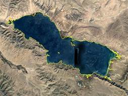
Figure 1 Data map with Google image of Donggi Conag Lake (.kmz format)
|
Donggi Conag Lake, also known as Toso Lake or Black Sea, is located in Madoi county, Golog Tibetan autonomous prefecture, Qinghai province, China (“Madoi” means the source of Yellow River in Tibetan language). It lies in the eastern end of Kunlun Mountains, between the Anyemaqen Mountain (south) and Burhabuda Mountain (north). The Animaqing Mountains, located in the south of the Lake, separates the Lake from Gyaring Lake and Ngoring Lake which are originated from Yellow River. The geo-location of the Lake is 35°12′33″N-35°23′2″N, 98°20′52″E-
98°44′54″E (Figures 1-2). It is a large fresh water lake resulted from the Tuosu River, the upper reach of Xiangrde River, in the southern side of Qaidam Basin. Donggi Conag Lake is an enclosed plateau fresh water lake formed by the fault depression of East Kunlun orogenic structure, with an average elevation of 4,090 m, 10 km width in south-north direction, and 45 km long in east-west direction. The lake water is deep blue, fresh, and drinkable. There are abundant Huang fish in the lake[3]. The bottom of the lake is uneven, with sediments in different compositions, such as muddy bottom, sandy bottom, rocky bottom, and weedy bottom.
The area of Donggi Conag Lake (2015) is 243.82 km2, and the shoreline is 165.05 km. There are eight islands in the lake, among which the biggest one has an area of 314,295 m2 and the smallest one has an area of 542 m2[2]. There are migratory birds gathering in the islands, such as red-crowned crane, teal, sea gull, and cormorant.
|
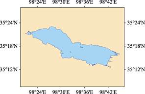
Figure 2 Data map of Donggi Conag Lake (.shp format)
|
The Lake is in the typical alpine steppe climate zone, with a long cold season and big temperature difference. According to the records of meteorological station in Madoi county, the annual mean temperature of this area is -5.2–-2.3 oC, the annual frost-free season is only 2-3 days, the annual average precipitation is about 300 mm, and the annual evaporation is about 1,300 mm[4]. The lake water is mainly from glacial meltwater, surface runoff and underground flow. The water is mainly recharged by Dongqu River and Xiemaangli River, and Yuegerouqu River. Among them, Dongqu River and Xiemaangli River are originated from the Animaqing Mountains, southeast of the Lake, and Dongqu River is the largest recharge runoff of the Lake[4‒5]. Normally, Donggi Conag Lake will freeze at December and melt again in May of the following year, with the ice layer of 30-60 cm.
The No. G0615 inter-provincial highway of China (from Dema to Delingha-Maerkang highway) is passing by from east to west in the north side of Donggi Conag Lake, while the No. G214 road (from Xining city of Qinghai province to Jinghong city of Yunnan province) is passing by from north to south in the east side of Donggi Conag Lake. These two roads are crossed in the northeast of Donggi Conag Lake, forming the convenient road transportation network to the Donggi Conag Lake[5].
The dataset was developed based on Google Earth images (2015) and related maps. The dataset is consisted of 22 data files, archived in both .kmz and .shp[6] formats with data size of 3.26 MB (compressed to 1.14 MB in two files).
References
[1] Wang, S. M., Dou, H. S. China Lake Record [M]. Beijing: Science Press, 1998.
[2] Gou, Z. J., Liu, F. G. Donggi Conag Lake [DB/OL]. Global Change Research Data Publishing & Repository, 2018. DOI: 10.3974/geodb.2018.08.14.V1.
[3] Editorial Office of Encyclopedia of Rivers and Lakes in China. Encyclopedia of Rivers and Lakes in China: Section of River Basins in Southwest Region [M]. Beijing: China Water & Power Press, 2014.
[4] Editorial Office of County Annals of Madoi. County Annals of Madoi County [M]. Beijing: China County and Town Yearbook Publishing House, 2001.
[5] Editorial Office of Local Chronicles of Madoi County. County Annals of Madoi County [M]. Xining: Qinghai Ethnic Publishing House, 2011.
Data Computing Environment
[6] ESRI. ArcGIS campus license of Institute of Geographic Sciences and Natural Resources Research, Chinese Academy of Sciences.
URL for Data Downloading
http://www.geodoi.ac.cn/WebEn/doi.aspx?Id=1104.
Or search through: http://www.geodoi.ac.cn.