Erosion-deposition Dataset of Yalu River Region in
Northeast China
Chen, X.1 Chen, S. B.1* Zhang, P.1 Xiang, T. T.2 Zhou, H.1 Yu, Y. F.1
1. College of GeoExploration Science and Technology, Jilin University, Changchun 130026, China;
2. Changchun School of Architecture, Changchun 130607, China
Abstract: The Yalu River region in northeast of China was divided into 2,850 single slope using ASTER GDEM data with a spatial resolution of 30 m, then the average slope and length of each single slope were calculated. Integrating with Zhalantun metrological station data, land cover and soil data and the WEPP model (water erosion prediction models), 14 Erosion-deposition balance points of Yalu River region were discovered. The Erosion-deposition dataset of Yalu River region in northeast of China consisted all of these erosion-deposition points and their geographical indicators.
Keywords: the Northeast Plain; Yalu River region; WEPP model; erosion-deposition process
1 Introduction
Yalu River region is the transition region of the Greater Khingan Mountains and the Northeast Plain. Analyzing the Erosion-Deposition process of YaluRiver has an indicative significance in quantitative extraction of Northeast Plain boundary. The Greater Khingan Mountains is a part of the boundary of China’s terrain, so it is also significant for extracting the boundary of China’s terrain[1]. In this paper, WEPP model was used to study the Erosion-Deposition process of Yalu River, and the Ero-DepoData_YaluRiver_NE_China was developed.
2 Metadata of Dataset
The Ero-DepoData_Yalu River_NE_China dataset is summarized in Table 1. It includes the dataset full name, short name, authors, year of the dataset, temporal resolution, spatial resolution, data format, data size, data files, data publisher, and data sharing policy, etc.
3 Method
3.1 Basic Data
The data from China Meteorological Data Sharing Service System[4] and ASTER GDEM data was used in this paper[5].
Table 1 Metadata summary of erosion-deposition basic dataset of Yalu River region in Northeast China[2]
|
Items
|
Description
|
|
Dataset full name
|
Erosion-deposition dataset in facets of Yalu River watershed in Northeast China
|
|
Dataset short name
|
Ero-DepoData_Yalu River_NE_China
|
|
Authors
|
Cheng, X. L-4911-2016, College of GeoExploration Science and Technology, Jilin University, honeyxue0107@126.com
Chen, S. B. L-5789-2016, College of GeoExploration Science and Technology, Jilin University, chensb@jlu.edu.cn
Zhang, P. L-5219-2016, College of GeoExploration Science and Technology, Jilin University, 746674932@qq.com
Xiang, T. T. L-5672-2016, Changchun School of Architecture,
xiangtiantian1029@163.com
Zhou, H. L-4968-2016, College of GeoExploration Science and Technology, Jilin University, bb625218858@163.com
Yu, Y. F. L-5386-2016, College of GeoExploration Science and Technology, Jilin University, yuyaf2011@163.com
|
|
Geographical region
|
121°25′-122°52′E??47°53′-48°52′N
|
|
Time
|
2015
|
|
Temporal resolution
|
Daily
|
|
|
|
Spatial resolution
|
30 m
|
Number of tiles
|
2
|
|
Data format
|
.rar, .kmz
|
Data Size
|
7.1 MB
|
|
Dataset and data files
|
The Ero-DepoData_Yalu River_NE_China consists of two files. They are Ero-DepoData_Yalu River_NE_China.rar and Yalu River.kmz.
1. Ero-DepoData_Yalu River_NE_China.rar, this is the raster and vector data. Data size is 5,842.54 KB
2. Yalu River.kmz, this is the Yalu River doundary geographic information system data. Data size is 1,433.61 KB
|
|
Foundation(s)
|
National Natural Science Foundation of China (78659, 12784); Chinese Academy of Sciences (A75123)
|
|
Data publisher
|
Global Change Research Data Publishing & Repository, http://www.geodoi.ac.cn
|
|
Address
|
No. 11A, Datun Road, Chaoyang District, Beijing 100101, China
|
|
Data sharing policy
|
Data from the Global Change Research Data Publishing & Repository includes metadata, datasets (data products), and publications (in this case, in the Journal of Global Change Data & Discovery). Data sharing policy includes: (1) Data are openly available and can be free downloaded via the Internet; (2) End users are encouraged to use Data subject to citation; (3) Users, who are by definition also value-added service providers, are welcome to redistribute Data subject to written permission from the GCdataPR Editorial Office and the issuance of a Data redistribution license; and (4) If Data are used to compile new datasets, the ‘ten per cent principal’ should be followed such that Data records utilized should not surpass 10% of the new dataset contents, while sources should be clearly noted in suitable places in the new dataset[3]
|
3.2 Process of the Dataset Research
Ero-DepoData_YaluRiver_NE_China dataset was created by WEPP model. WEPP (Water Erosion Prediction Project) is a physical description of rill erosion, interrill erosion and the sediment motion mechanisms, which can predict the soil erosion, sediment yield and sediment discharge in different areas[6]. The process of data research is shown in Figure 1.
|
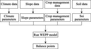
Figure 1 The Flowchart of Ero-DepoData_YaluRiver_NE_China research
|
|
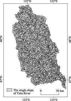
Figure 2 The single slope of Yalu River basin
|
In this process, the climate database was established using climate data which includes daily precipitation, daily maximum tem-
perature and daily minimum temperature downloaded from China Meteorological Data Sharing Service System. The climate data was used to model the meteorological station in Yalu River using CLIGEN Generated in the WEPP model[7]. The soil database was established according to the soil type and physical and chemical properties. Six soil parameters was determined in the WEPP model[8]. The crop management database was established using GlobCover2009 data which can layered extract different types of ecological regions with hierarchical classification. The GlobCover2009 data uses the Land Cover Classification System (LSCC) to divide the land surface into 22 land cover types[9]. Then the crop parameters was determined in the WEPP model by the land use types of Yalu River. DEM data was divided into several single slope by ArcGIS (Figure 2). The slope data was calculated by Zonal Statistics in ArcGIS (Figure 3). The slope length data was calculated by Raster Calculator and Zonal Statistics[10] (Figure 4). After calculating the mean slope and mean slope length by ArcGIS, the slope database was obtained using the WEPP model.
Accoding to the climate, slope, soil and crop management database, the 2,850 single slope of Erosion-Deposition under different slope and different slope length in Yalu River River basin were obtained using the WEPP model. The Erosion-Deposition balance point was determined by the equal amount point of soil erosion and deposition.
4 Dataset Compositions, Quality Control and Validation
4.1 Dataset Compositions
4.1.1 Ero-DepoData_YaluRiver_NE_China.rar
Ero-DepoData_YaluRiver_NE_China. rar includes raster and vector data. Data size is 5,842.54 KB. The raster data includes MeanSlope.img and MeanLength.img.
|
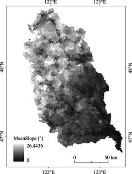
Figure 3 The slope of Yalu River basin
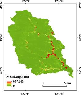
Figure 4 The slope length of Yalu River basin
|
The vector data includes YaluRiver.shp and Balance_Point.shp. YaluRiver.shp includes the slope length (Length), slope (°), the erosion amount of 14 balance points (Soil_Loss) and deposit amount (Deposition). Balance_Point.shp is the location of balance point which has the same value of erosion and deposit amount.
4.1.2 YaluRiver.kmz
YaluRiver.kmz is the GIS data of the Yalu River basin in the Google Earth format.
4.2 Quality Control and Validation
According to the dividing method of China’s terrain by predecessors, elevation and slope were reclassified in Northeast China region to be the boundary between the Greater Khingan Mountains and the Northeast Plain. The balance points we have obtained compared with the boundary qualitatively extracted by the elevation and slope, showing the balance position can basically match with the boundary (Figure 5, Figure 6). The result indicates that the data is reliable.
5 Discussion and Conclusion
Based on analysis of climate, soil, slope and crop management datasets in the Yalu River basin, basic data and reference data were analyzed to map the erosion-
sedimentation process of the eastern slope of the Greater Xing’an Mountains. Results show that this quantitative analysis can identify the dividing line between the Greater Xing’an Mountains and the
Northeast Plain. The data has reference value for quantitative classification of the Northeast Plain.
|
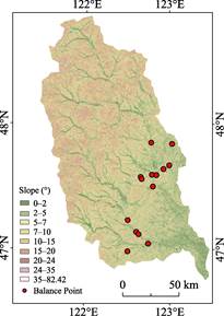
Figure 6 Map of the balance position and slope classification
|
|

Figure 5 Map of the balance position and
elevation classification
|
Author Contributions
Chen, S. B. proposed the use of watershed erosion-sedimentation balance indicators as the dividing line of Northeast China’s academic thought, Xiang, T. T. was responsible for the design and research data sets. Cheng, X. wrote the paper. Cheng, X., Chen, S. B., Zhang, P., Xiang, T. T., Zhou, H. and Yu, Y. F. contributed to the data processing and analysis. Cheng, X. validated analysis undertaken for this study and composed this manuscript.
References
[1] Xia, B. C., Hu, J. M., Song, X. S. Analysis of land-use change in Yaluhe catchment during last 15 years [J]. Journal of Soil and Water Conservation, 2004, 8(2): 122-125.
[2] Cheng, X., Chen, S. B., Zhang, P., et al. Erosion-deposition basic dataset of Yalu River region in Northeast China [DB/OL]. Global Change Research Data Publishing & Repository, 2015. DOI: 10.3974/geodb.
2015.01.06.V1.
[3] GCdataPR Editorial Office. GCdataPR Data Sharing Policy [OL]. DOI: 10.3974/dp.policy.2014.05 (Updated 2017).
[4] China Meteorological Data Sharing Service System. http://cdc.cma.gov.cn/home.do.
[5] U.S. Geological Survey. https://www.usgs.gov/.
[6] Zhang, Y. B., Zheng, F. L, Jia, Y. Y. WEPP model and its application [J]. Research of Soil and Water Conservation, 2004, 11(4): 146-149.
[7] Xiao, P. Q., Yao, W. Y. Erosion theoretical basis of WEPP model [J]. Yellow River, 2005, 27(6): 38-50.
[8] Xiang, T. T. Studying on process of erosion-deposition on eastern slope of Great Khingan and its indicative significance [D]. Changchun: Jilin University, 2014.
[9] Ma, L., Zuo, C. Q. Major factors affecting erosion and runoff on red soil slope based on WEPP model [J]. Bulletin of Soil and Water Conservation, 2012, 32(6): 26-33.
[10] Kong, Y. P., Zhang, K. L., Cao, L. X. Appraise slope length factors in soil erosion study [J]. Research of Soil and Water Conservation, 2008, 15(4): 43-47.