Earth Data Encyclopedia
Boundary Data of the Yenisei River Basin
Huang, Y. F.1* Li, T. J.1 Lv, E. Z.1 Li, J. Y.1 Bai, R.1 Liu, C.2 Zha, F. L.2
1. State key laboratory of hydroscience and engineering, Tsinghua University, Beijing 100084, China;
2. Institute of Geographic Sciences and Natural Resources Research, Chinese Academy of Sciences, Beijing 100101, China
Keywords: Yenisei River basin; boundary; Arctic Ocean; geography of the world; data encyclopedia
|
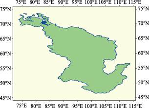
Figure 1 Geolocation of the Yenisei River Basin
|
Yenisei River (Russian: Енисе́й) Basin covers the area of Yenisei River and its tributaries including the Angara River, Podkamennaya Tunguska River, Nizhnyaya Tunguska River, Kemchuk River, Abakan River, Tuba River and Kan River. The Yenisei River rises from south of the Chovsgol Nuur of Mongolia. After merges of the Ider River and Wood Aaron River, it flows and merges with Orkhon River into Selenga River. After the Lake Baikal, then Angara River follows almost a northerly way between 95ºE-85ºE to the Yenisei Gulf in the Kara Sea of Arctic.
The geolocation of the Yenisei River Basin is from 73°37′43″E in west to 113°50′53″E in east and from 46°27′28″N in south to 73º38′24″N in north, see Figure 1. The total area of the river basin is 2,659,698.58 km2,the boundary of the basin is 31,237.98 km long. The dataset was developed based on the ASTER-DEM with the statistic models in 30 m resolution and validated by the google earth images in meter mostly. The data is archived in both .kmz and .shp data formats with the compressed data size of 26.5 MB.