The Spatial Distribution Dataset of 2666 Chinese
Traditional Villages
Yu, L.* Tang, M. J. Fu, M. Liu, Z. T. Qiu, Y. C. Cao, L. L. Yang, X. H.
Shen,
J. X.
School of Architecture, Soochow
University, Suzhou 215123, China
Abstract: Following the list of Chinese traditional villages released by the
Ministry of Housing and Urban-Rural Development of P. R. China, Ministry of
Culture of P. R. China, and Ministry of Finance of P. R. China from 2012 to
2016, 2,666 Chinese traditional villages were released in June 2019. Using GIS
methodology, the dataset was developed based on the information about the names
of the new listed villages or geo-location of villages from Baidu Map and
Google Earth images. Furthermore, more historical documentation or images helped
to determine village geo-location. In a few cases, if a village was not found
on the map, nor Google Earth image, the upper-level administrative resident
village nearby was adopted. The dataset was archived in .shp and .kmz data
formats with a data size of 7.48 MB in 6 data files (compressed to 362 KB in
two data files).
Keywords: China; traditional villages; list; spatial
distribution; the fifth batch
DOI: https://doi.org/10.3974/geodp.2022.01.03
CSTR: https://cstr.escience.org.cn/CSTR:20146.14.2022.01.03
Dataset Availability Statement:
The dataset
supporting this paper was published and is accessible through the Digital Journal of
Global Change Data Repository at: https://doi.org/10.3974/geodb.2020.03.22.V1 or
https://cstr.escience.org.cn/CSTR:20146.11.2020.03.22.V1.
1 Introduction
Traditional villages are spread all over the world, depict
various forms of gathering and living since the birth of human beings, and are
valuable historical and cultural heritage. They exhibit different
characteristics that correlate to different regions. Due to the needs of
long-term life and activities, a large number of traditional dwellings exist in
traditional villages, which form inseparable interdependent relationships
between them. For over ten years, the author has investigated dozens of
villages in China, been impressed by the vivid regional characteristics of
villages and dwellings and the exquisite skills of builders, and has empathized
with the collapse of some villages and dwellings due to failure to improve and
reconstruct on time. This is coming at a time when the country is aggressively
advocating ??Lucid waters and lush mountains are invaluable assets?? and rural
revitalization, timely and sustained protection, and reconstruction work are
very essential (Figure 1).
The spatial distribution dataset of 2,666 additional
Chinese traditional villages includes the reorganization and publishing of the
2,555 village spatial distribution dataset and the 1,598 village spatial
distribution dataset[1,2] in the previous period. This data source
does not only identify and interpret the administrative division and
subordination relationship at the grassroots level of villages and above, such
as from towns and townships to counties but also compares and confirms the
geographical location of the corresponding villages, and analyses the spatial distribution
characteristics, thus illustrating the outstanding rural culture and
stimulating the spiritual essence of traditional villages.

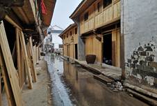
Figure
1 The fifth batch of
traditional villages: preservation and restoration of dwellings (Left: Dongpu
village, Dongpu street, Yuecheng district, Shaoxing city, Zhejiang province;
Right: Beilei village, Fotang town, Yiwu county, Jinhua city, Zhejiang province,
by Yu, L., in 2017 and 2020)
2 Metadata of the Dataset
The metadata of The spatial distribution dataset of 2666
additional Chinese traditional villages[3] is summarized in Table 1.
It includes the full name, authors, data format, data size, data files, data
publisher, and data sharing policy, etc.
Table 1 Metadata summary of
the Spatial distribution dataset of 2666 additional Chinese traditional
villages
|
Items
|
Description
|
|
Dataset full name
|
The spatial distribution dataset of 2666 more Chinese
traditional villages
|
|
Dataset short name
|
VillagesChina2666
|
|
Authors
|
Yu, L. F-8099-2018, School of Architecture, Soochow
University, yuliang_163cn@163.com
Tang, M. J. O-6467-2018, School of Architecture, Soochow
University, 361988267@qq.com
Fu, M. O-6455-2018, School of Architecture, Soochow University,
821064405@qq.com
Liu, Z. T. ABH-4639-2020, School of Architecture, Soochow
University, 785025073@qq.com
Qiu, Y. C.ABH-5207-2020, School of Architecture, Soochow
University, 375284315@qq.com
Cao, L. L. ABI-1416-2020, School of Architecture,
Soochow University, 1083748619@qq.com
Yang,
X. H. ABH-6245-2020, School of Architecture, Soochow University, 654712015
@qq.com
Shen, J. X. ABH-7152-2020, Tongji Zhejiang College, 409209740
@qq.com
|
|
Geographical region
|
China, 31 provincial-level administrative regions (Hong
Kong, Macao, and Taiwan without data)
|
|
Year
|
2012-2019 Data format
.shp, .kmz
|
|
Data size
|
4.50 MB
|
|
Data files
|
Two files (VillagesChina2666.kmz + VillagesChina2666.rar )
|
|
Foundation
|
National Natural Science Foundation of China (41371173)
|
|
Data publisher
|
Global Change Research Data Publishing & Repository,
http://www.geodoi.ac.cn
|
|
Address
|
No. 11A, Datun Road, Chaoyang District, Beijing 100101, China
|
|
Data sharing policy
|
Data from
the Global Change Research Data Publishing & Repository includes metadata, datasets
(in the Digital Journal of Global Change Data Repository), and
publications (in the Journal of Global Change Data & Discovery). Data sharing policy
includes: (1) Data are openly available and can be free downloaded via the
Internet; (2) End users are encouraged to use Data subject to
citation; (3) Users, who are by definition also value-added service
providers, are welcome to redistribute Data subject to written permission
from the GCdataPR Editorial Office and the issuance of a Data redistribution
license; and (4) If Data are used to compile new
datasets, the ??ten per cent principal?? should be followed such that Data
records utilized should not surpass 10% of the new dataset contents, while
sources should be clearly noted in suitable places in the new dataset[4]
|
|
Communication and searchable system
|
DOI, CSTR, Crossref, DCI, CSCD,
CNKI, SciEngine, WDS/ISC, GEOSS
|
3 Point Data Processing of Village Location
The list of villages does not show spatial locations;
however, it displays a line of name texts with administrative subordination as
well as location names. The location of village space point data is based on
the extraction of text name information, and it was located and obtained by
comparing and identifying the spatial form characteristics of villages. For the
spatial cognition of villagers that reside in a compact community, the main
constituent element is a residential building, with fields, rivers, and
infrastructure such as roads. Dwellings not only have a large horizontal plane
on rooftops in space, but are distinct from other object features, for example,
the natural elements of mountains, plants, and water surfaces, as well as
artificial elements such as roads, bridges, etc. The space point data exploits
the characteristics that the roofs have significant differences between other
objects, and their graph-structured forms can easily be recognized.
3.1 Data Sources
Raw data of villages: The quantity of the fifth batch of
villages listed in the list of traditional Chinese villages (Finally published)
is 2,666 (Compared with the initial figure, 22 new villages were added and 2
villages were deleted)[5]. The dataset spans 30 provincial
administrative regions, and in addition to the three batches of national
traditional villages that were published, the total number of villages in the
list reached 6,819. The increment is obvious, especially the rise from 60% to
65% in the fourth batch to the fifth (Figure 2).
3.2 Location Data and Names of
Villages
Data acquisition of the village space point is highly
similar to the previous two occasions[1,2]. There are two steps:
first, the space point data positioning, which requires distinguishing the
differences in space between the villages and natural or artificial objects and
focusing on the relatively orderly protruding individuals with small volume; second,
sorting village names, in a bid to draft a regular attribute sheet using the
semi-automatic method combined with the manual one. Semi-automatic means using
Excel-related tools and methods to improve efficiency. Tools applied include
left, right, mid-function, and advanced classification to directly identify the
data segments of village names. The macro of the Excel tool is used to
translate the characters into pinyin. Then, a new module is inserted into the
visual basic editor. After inputting a code and defining the function
meticulously, the Chinese characters are converted and the initial case is
processed. Without any doubt, these methods are different from the previous
two. The manual method targets unusual names, such as segments of autonomous
regions, streets, communities, towns, and villages, which are executed after
semi-automatic processing, as detailed as follows.
|

Figure
2 Trends of the number of first to fifth
batch of villages
|
The positioning of the
village space point data is inputted into the Baidu Map to obtain the point
location of the village after which it is imported to Google Earth Map. The
coordinate difference of the space point location is adjusted online by the manual
visual method to determine whether the point falls on the roofs of ancient
buildings in the village and on the geometric center position, which represents
the spatial characteristics of the village. The positioning of the data at each
point is not obvious and requires several manual adjustments. The main issue
with the positioning, including on the first two occasions, is that it is not
easy to judge. After the Baidu Map imports data to Google Earth Map, changing
the original position becomes much easier. For example, the point located on
the roof will be shifted to the field or pond, etc., and with the significant
increase in data size between the fifth batch and the fourth batch, the
workload of adjustment increases heavily. In addition, for names that are
difficult to identify and lack clues, based on inquiries made for relevant
information or direct contact with the village for confirmation, if it is
really difficult to position the village, it should be assigned to the
administrative unit up to one level[1].
3.3 Sorting out the Name of the
Villages
Villages are grass root level organizations, and a series
of names in the list are direct clues to obtain the location of the villages,
especially the marks at the end. This implies that the sign of names at the end
of the village is varied, but not uniform, which may be related to the Chinese
multi-ethnic and multi-climatic characteristics[6]. The processing
method is mainly to confirm the administrative levels and subordinate relations
of the attribute sheet, segments from provinces, cities, and counties to towns
and villages. Five administrative levels exist because the five administrative
levels of general provinces are different from the four administrative levels
of municipalities directly under the central government. This dataset is based
on five columns, sets a municipality directly under the central government and
the general municipal repeated column segments, such as the column ??Beijing?? is
repeated in level one and level two of the column ??Heilongguan village,
Fozizhuang town, Fangshan district, and Beijing??.
|
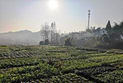 
Figure 3 The development relationship between towns and
villages (The fifth patch, Jinyan village, Maotanchang town, Jin??an district,
Liu??an city, and Anhui province, left: Jinyan village; right: Maotanchang old
street, by Yu, L., 2020)
|
Secondly, by observing the administrative
sequence from province to village, it can be seen that many villages have
sixth-level endings after the fifth level of administrative affiliation
relationship, reflecting that multiple spatial positions need to be identified
and located. According to the roof image, if it is clear that the sixth level
can be identified, and will be at the sixth level. If it were not obvious, it
would be at the fifth level. The ??village?? is the most
frequent, but it doesn??t necessarily end with it; there are 2,598
villages that end with ??village?? in the fifth batch of five-level villages
(Table 2), next is 34 villages in the ??community?? section, 27 in ??cuncun??,
3 in ??old
street?? and
??tun??, and 1 in ??gacha?? (Equivalent to an administrative
village). There are no ??neighborhood committees and village
committees??.
At the fifth and sixth levels, the administrative village is generally
connected to the natural village, such as ??Hongyan old village-tun, Zhushan
village committee, Lianhua town, Gongcheng Yao autonomous county, Guilin city,
and Guangxi province.?? ??Zhushan village committee?? is the 5th
village level, ??Hongyan
old village-tun?? is the six-level natural village, and should
be positioned on the ??Hongyan old village-tun??. If it is difficult to decipher, it will
be located in the upper ??Zhushan village committee??. Generally,
an administrative village mostly corresponds to one natural village, and
there are multiple corresponding villages as well, such as ??Liuxiang tun, Langchong
tun, Shangguchen tun?? in ??Liuxiang village, Liuxiang town, Jinxiu Yao
autonomous county, Laibin city, and Guangxi province??. 401
villages have sixth-level labels in the fifth batch of the village (15.04% of
2,666), the tails are ??village, group, zhai, tun, zhaicun, ditch, slope, street,
zhuang, and bay??.
The most common is ??village??. There are 262 villages, followed by the
45 in ??group??, 43 in ??zhai??, and ??zhuang?? and ??bay?? are just
one. The form is diverse, the number of combinations differs as a whole, and
the name vividly reflects the local natural landscape features.
Table 2 Village level 5 and 6 and the suffix of ??ancient?? and ??old??
|
No
|
The fifth level
|
Amount
|
The sixth level
|
Amount
|
Combine ??ancient?? and ??old??
endings
|
Amount
|
|
1
|
Village
|
2,598
|
Village
|
262
|
Ancient village
|
6
|
|
2
|
Community
|
34
|
Group
|
45
|
Ancient zhai
|
3
|
|
3
|
Cuncun
|
27
|
Zhai
|
43
|
Ancient zhaicun
|
1
|
|
4
|
Old
street
|
3
|
Zhaicun
|
10
|
Old street
|
3
|
|
5
|
Tun
|
3
|
Tun
|
29
|
Old-street
village
|
3
|
|
6
|
Gacha
|
1
|
Ditch
|
4
|
|
|
|
7
|
Neighborhood
committee
|
0
|
Slope
|
4
|
|
|
|
8
|
Village
committee
|
0
|
Street
|
2
|
|
|
|
9
|
|
|
Zhuang
|
1
|
|
|
|
10
|
|
|
Bay
|
1
|
|
|
|
Total
|
|
2,666
|
|
401
|
|
16
|
Additionally, there are endings
with ??ancient village??, ??ancient zhai??, and ??old street?? derived from the combination of ??ancient?? and ??old??, both at levels 5 and
6. We do not want to pay attention to when the endings ??ancient village?? and ??old street?? should be used, or
what should be intended in any ??ancient-old?? combination. At least, there are more clues
for attention when it comes to spatial positioning. When positioning the fifth
batch of villages, there is no spatial difference between the combination of ??ancient?? and ??old??. For example, if
without further investigation, it is difficult to distinguish whether ??Gu?? in ??Baigu village, Puli village, Zhongshan township, Luoping
county, and Qujing city?? means ??ancient??. There are six ??ancient villages?? and three ??ancient zhai?? in the villages. In
addition, there are three ??old streets??. Among them, although ??Beizha old street in Zhegao town?? and ??Tongyang
old street in Tongyang town?? in Chaohu city, Anhui province are village level,
according to the field investigation, there is a close relationship between the
village and the town. The development of the town has traces of the village.
The expansion of the village provides the basis for the development of the
town. In space, it exhibits the characteristics of integration. These spatial
phenomena can be inferred and supported by remote sensing images and applied in
positioning.
Generally speaking, towns have more commercial and administrative functions
than villages. Some villages are ??surrounded?? by the new towns in space, while some are neighbors. Through
the epoch, many villages exited the former state, and their structure,
boundary, and mechanism changed tremendously. For example, ??Jinyan village, Maotanchang town, Jin??an district, Liu??an city, and Anhui
province?? (Figure 3) in the fifth batch of
villages, the village is near the town, and some locals refer to the old street
of the town as the old buildings of the village. This highlights the close
spatial relationship between them. Generally, if it were to be a village in
space, we would position the point on the village. Otherwise, it would be
positioned on the old street or the old buildings in the town. Similar
characteristics are also reflected in the old street of Tongyang town, Chaohu
city, and Anhui province, and the old street of Beizha town, Zhegao town, Chaohu
city, and Anhui province.
Finally,
the spatial location points of the sixth levels (401 in total) are shown in
Table 3. It can be seen that the sixth level is the most common. Also, the
locating point of the fifth level and the fourth level follow the rules, which
is in line with the aforementioned method that if the location of the level is
difficult to find, the administrative unit of any one level above will be
assigned.
Table 3
Locate numbers of the sixth level village
|
The sixth level
Locate
point
|
Village
|
Group
|
Zhai
|
Stockaded village
|
Tun
|
Gou
|
Slope
|
Street
|
Zhuang
|
Bay
|
Amount
|
|
The sixth level
|
196
|
11
|
18
|
6
|
15
|
1
|
1
|
1
|
1
|
1
|
253
|
|
The fifth level
|
58
|
28
|
23
|
4
|
12
|
1
|
3
|
1
|
0
|
0
|
130
|
|
The Fourth level (Town)
|
5
|
5
|
2
|
0
|
1
|
0
|
0
|
0
|
0
|
0
|
9
|
|
The Fourth level (Countryside)
|
3
|
5
|
0
|
0
|
1
|
0
|
0
|
0
|
0
|
0
|
9
|
|
Total
|
262
|
45
|
43
|
10
|
29
|
4
|
4
|
2
|
1
|
1
|
401
|
4 Datasets Results and Discussion
|
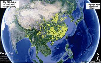
Figure 4 Spatial distribution of the fifth batch of
2,666 villages (Google Earth)
|
The dataset
consists of two files: 1) VillagesChina2666.rar, which is composed of seven
data files in ArcGIS with a data size of 4.50 MB; 2) VillagesChina2666.kmz,
which is two files with a data size of 258 KB in Google Earth.
This
dataset can be used to understand the spatial distribution of the traditional
villages easily. The data of the 2,666 villages are shown in Figure 4 (Google
Earth). It can be seen that the spatial distribution of villages remains
uneven, same as the previous batches, with more villages in the southeast and
fewer in the northwest. The largest number in Hunan is 401, with 265 in Fujian,
237 in Anhui, and 235 in Zhejian. The least are Beijing, Tianjin, Ningxia, and
Xinjiang. The several batches in Ningxia are fewer and the decline in Xinjiang
is transparent. There aren??t any traditional villages collected in the list for
the four consecutive batches in Shanghai, it seems that urbanization has
influenced the declining number of traditional villages.
Author Contributions
Yu, L. made an overall design for the acquisition and
development of datasets, and wrote data papers; Tang, M. J., and Liu, Z. T.
compiled the key data; Fu, M., Qiu, Y. C., Cao, L. L., Yang, X. H., and Shen,
J. X. collected and processed the dataset.
Conflicts
of Interest
The authors declare no
conflicts of interest.
References
[1]
Yu, L., Liu,
J., Ding, Y. Q., et al. The spatial
distribution dataset of 2555 Chinese traditional villages [DB/OL]. Global
Change Data Repository, 2018. https://doi.org/10.3974/geodb.2018.04.06.V1. https://cstr.escience.org.cn/CSTR:20146.11.2018.04.06.V1.
[2]
Yu, L.,
Ding, Y. Q., Tang, M. J., et al.
Spatial distribution dataset of 1598 more traditional villages in China
[DB/OL]. Global Change Data Repository, 2019.
https://doi.org/10.3974/geodb.2019.01.19.V1. https://cstr.escience.org.cn/CSTR:20146.11. 2019.01.19.V1.
[3]
Yu, L.,
Tang, M. J., Fu, M., et al. Spatial
distribution dataset of 2666 more traditional villages in China [J/DB/OL]. Digital Journal of Global Change Data
Repository, 2021. https://doi.org/10.3974/geodb. 2020.03.22.V1. https://cstr.escience.org.cn/CSTR:20146.11. 2020.03.22.V1.
[4]
GCdata PR
Editorial Office. GCdata PR data sharing policy [OL].
https://doi.org/10.3974/dp.policy.2014.05 (Updated 2017).
[5]
Ningxia Hui
Autonomous Region, The Ministry of Housing and Urban-Rural Development [OL].
http://jst.nx.gov.cn/info/1077/30836.htm.
[6]
He, M. L.,
Ding, X. H., Yu, K. X. Spatial distribution characteristics of place-names in
Zhuji from the perspective of geomorphology [J]. Science of Surveying and Mapping, 2020, 45(11): 147‒153.