1 km Resolution Dataset of Vegetation Net Primary Productivity over China-ASEAN (2013)
Gao, S. Liu, Q. H.* Kang, J. Zhao, J. Li, J. Zhong, B. Wu, S. L. Peng, J. J.
State Key Laboratory of Remote Sensing Science, Institute of Remote Sensing and Digital Earth, Chinese Academy of Sciences, Beijing 100101, China
Abstract: NPP (net primary productivity) could reflect the carbon sequestration ability of vegetation and the initial material and energy into the terrestrial ecosystem. Based on the model of light use efficiency, NPP products with 1 km/5 day in China-ASEAN region were produced based on the MODIS vegetation classification product MOD12 and the related data products including photosynthetically active radiation, photosynthetically active radiation absorption ratio and leaf area index. In order to overcome the constraints of ground temperature and other parameters, NECP (National Centers for Environmental Prediction) reanalysis of temperature products were used to ensure the effectiveness of the product. The results of the inversion were compared with MODIS products and related flux data and the results showed a good agreement with the existing products.
Keywords: China-ASEAN region; net primary productivity; light use efficiency; fraction of photosynthetic active radiation; Leaf area index
1 Introduction
Net primary productivity (NPP) is the remainder of gross primary productivity (GPP) minus the Autotrophic Respiration (Ra) for green plant[1]. NPP plays an important role in the prediction of future atmospheric CO2 and other greenhouse gases, and in the understanding of the interaction between atmosphere and biosphere. NPP is also key parameter in water cycle, nutrient cycling, biodiversity change, and carbon cycle in terrestrial ecosystem. Since NPP reflects the production capacity of plant community under natural environment, it is an important ecological index to evaluate the sustainability terrestrial ecosystem[2].
The main purpose to develop this dataset[3] is to overcome the limit of single data source for high temporal resolution vegetation NPP based on the satellite network technology. In the process of modeling, the complementarity of various data and products were fully considered using satellite network to enhance NPP quality, especially temporal resolution. We constructed a high temporal resolution vegetation NPP model tailored to satellite network. In theory and application, it can meet the need for global NPP production on a 1-km spatial and 5-day temporal scale. The 1 km spatial resolution NPP product of China-ASEAN is one of the outcomes of China-ASEAN regional remote sensing monitoring project. This paper details the principles of algorithms and data reliability analysis.
2 Metadata of Dataset
The metadata of 1km spatial resolution NPP dataset in China-ASEAN is summarized in Table 1. It includes the dataset full name, short name, authors, year of the dataset, temporal resolution, spatial resolution, data format, data size, data files, data publisher, and data sharing policy.
3 Methods
3.1 Algorithm Description
Based on the principle of light use efficiency (LUE)[5–6], the productivity of regional terrestrial ecosystem productivity driven by remote sensing data was carried out for the production of NPP products. The model is driven by the photosynthetically active radiation (PAR), leaf area index (LAI), temperature and humidity data obtained by various satellite data, and the model parameters are optimized by process model. Based on the satellite network technology, data and related products, parametric model, plant physiological and ecological process model were incorporated into the NPP production algorithm. In theory, it could improve the NPP temporal resolution. At the same time, based on data products such as land cover, biomass, FPAR and stress factors, a global 1km resolution NPP production technology based on satellite network and virtual constellation data was developed and technology specifications were completed.
The basic principles of the algorithm are as follows:
 (1)
(1)
where PAR is for photosynthetically active radiation (MJ/m2); FPAR is Fractional Photosynthetically Active Radiation (-); ε* is the maximum light utilization rate (gC/MJ);
f (t) and f (w) are light energy utilization factors for the temperature and water impact on the LUE, respectively; Ra is vegetation autotrophic respiration amount (gC/m2).
3.2 Data Processing
The technical flowchart was shown in Figure 1. The input data of NPP light energy utilization model are various remote sensing radiation products, meteorological reanalysis data, and various existing products in our project. Through the simulation of process model parameters, a global 1 km/5-day NPP data products were calculated. In the production process, the radiation data uses the global PAR calculation method provided in this project and the daily global photosynthetically active radiation products to synthesize the photosynthetic active radiation needed by the project.
Table 1 Summary of the 1 km resolution NPP product over China-ASEAN (2013) metadata.
|
Items
|
Descriptions
|
|
Dataset full name
|
1 km/5-day net primary productivity product over China and the Association of Southeast Asian Nations for 2013
|
|
Dataset short name
|
MuSyQ-NPP-1km-2013
|
|
Authors
|
Gao, S. Q-2484-2017, the State Key Laboratory of Remote Sensing Science, Institute of Remote Sensing and Digital Earth, Chinese Academy of Sciences, gaoshuai@radi.ac.cn
Liu, Q. H. S-1647-2016, the State Key Laboratory of Remote Sensing Science, Institute of Remote Sensing and Digital Earth, Chinese Academy of Sciences, liuqh@radi.ac.cn
Kang, J. N-1268-2017, the State Key Laboratory of Remote Sensing Science, Institute of Remote Sensing and Digital Earth, Chinese Academy of Sciences, kangjun@pku.edu.cn
Zhao, J. A-3272-2017, the State Key Laboratory of Remote Sensing Science, Institute of Remote Sensing and Digital Earth, Chinese Academy of Sciences, zhaojing1@radi.ac.cn
Li, J. R-7298-2016, the State Key Laboratory of Remote Sensing Science, Institute of Remote Sensing and Digital Earth, Chinese Academy of Sciences, lijing01@radi.ac.cn
Zhong, B. L-4528-2016, the State Key Laboratory of Remote Sensing Science, Institute of Remote Sensing and Digital Earth, Chinese Academy of Sciences, zhongbo@radi.ac.cn
Wu, S. L. S-1572-2016, the State Key Laboratory of Remote Sensing Science, Institute of Remote Sensing and Digital Earth, Chinese Academy of Sciences, wsl0579@163.com
Peng, J. J. S-1261-2016, the State Key Laboratory of Remote Sensing Science, Institute of Remote Sensing and Digital Earth, Chinese Academy of Sciences, rspeggy@163.com
|
|
Geographic region
|
The geographical scope includes 10°55'12"S-53°32'24"N, 73°37'12"E-141°0'36"E. These include China, Indonesia, Malaysia, Philippines, Singapore, Thailand, Brunei, Vietnam, Laos, Burma and Kampuchea
|
|
Year
|
2013
|
|
Spatial resolution
|
1 km
|
|
Temporal resolution
|
5 d
|
|
Data format
|
.tif
|
|
Data size
|
1.84 GB
|
|
Data files
|
The MuSyQ-NPP-1km-2013 product was produced in the Sinusoidal tile grid, and distributed in 40 adjacent non-overlapping tiles that are approximately 10°×10° (at the equator). Each tile included 73 data files
|
|
Foundation(s)
|
Ministry of Science and Technology of P. R. China (2017YFA0603004, 2012AA12A304, 2012AA12A305, 2013AA12A301)
|
|
Data publisher
|
Global Change Research Data Publishing & Repository, http://www.geodoi.ac.cn.
|
|
Address
|
No. 11A, Datun Road, Chaoyang District, Beijing 100101, China.
|
|
Data sharing policy
|
Data from the Global Change Research Data Publishing & Repository includes metadata, datasets (data products), and publications (in this case, in the Journal of Global Change Data & Discovery). Data sharing policy includes: (1) Data are openly available and can be free downloaded via the Internet; (2) End users are encouraged to use Data subject to citation; (3) Users, who are by definition also value-added service providers, are welcome to redistribute Data subject to written permission from the GCdataPR Editorial Office and the issuance of a Data redistribution license; and (4) If Data are used to compile new datasets, the ‘ten per cent principal’ should be followed such that Data records utilized should not surpass 10% of the new dataset contents, while sources should be clearly noted in suitable places in the new dataset[4]
|
Vegetation growth status parameters from the project were used to provide a global 1km resolution 5-day FPAR product. Water Index (NDWI, the moisture of plant and soil) was used to describe the impact of moisture on LUE; and the NECP reanalysis temperature products was used to describe the impact of temperature on LUE. Vegetation Autotrophic Respiration Amount (Ra) was calculated using a semi-empirical formula [7–8]. The maximum utilization of light is based on the BGC model, which is initialized to the value of the MOD17 NPP product[9].
|
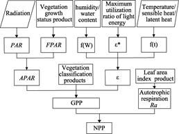
Figure1 Technical flowchart for global net primary productivity of vegetation
|
4 Results and Validation
The verification of the model algorithm is divided into two parts: qualitative verification and quantitative verification. Qualitative verification is mainly a method of using simulating data. It is necessary to carry out the production using the algorithm according to the requirements of time and space resolution. Then the actual data production was compared with simulated products. Quantitative verification use real data, the production of data, ground measured data, such as the flux tower data, etc.
4.1 Data Products
China and ASEAN 1km spatial resolution vegetation net primary productivity dataset was shown in Figure 2.
|
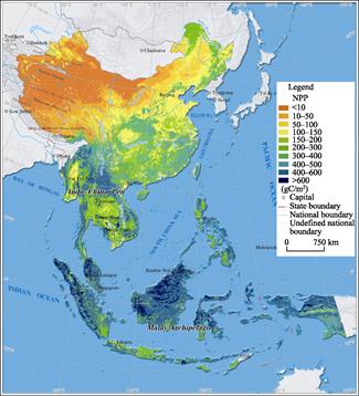
Figure2 Spatial distribution map of net primary productivity of
China-ASEAN (2013)
|
Figure 3 shows the spatial distribution of two NPP products in the Southeast Asian region. MODIS NPP products have a minimum value of 0 and MuSQ NPP product has a negative value. Two products have similar spatial pattern, yet the temporal resolution of MuSyQ NPP products is 5-day, much better than that of MODIS NPP products, which is only yearly.
4.2 Validation
4.2.1 Validation Area
High temporal resolution NPP is difficult to verify, therefore, only flux data was used in this study for indirect verification by the relationship with GPP. The selected flux station is located in the Daxinganling Genhe Ecological Location Research Station (121°31′10.344″E; 50°54′0.032″N) in Inner Mongolia. The Genhe Ecology Research Station is located in Genhe City, north of Hulunbuir City, covering 120°12′E to 122°55′E, and
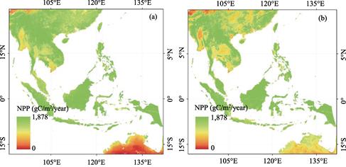
Figure 3 MODIS NPP (a) and MUSQ NPP (b) in the Southeast Asian region
50°20′N to 52°30′N, elevation between 784 and 1,142 m, average temperature -5.4 °C, the lowest temperature of -54 °C, >10 °C accumulated temperature 1,403 °C, annual precipitation of 450-550 mm, 60% concentrated in July to August, the average annual sunshine 2,594 hours, frost-free period of 80 days. The forest type is cold temperate coniferous forest, the main tree species is Larix gmelinii.
4.2.2 Validation Data
To validate the NPP product, the flux data of Genhe Ecological Location Research Station in the same period were obtained (Table 2).
Table 2 List of station observation data obtained by Genhe Ecological Location Research Station
|
Observation parameter
|
Instrument
|
Time
|
Interval
|
|
Albedo
|
|
|
|
|
LAI
|
Defoliation
collection frame
|
2010-2015
|
Monthly
|
|
60-meter tall tower: eddy correlation data (CO2 flux, latent heat flux, sensible heat flux, Ustar)
|
EC System
|
2011-
|
Half hour
average
|
|
60-meter tall tower: automatic weather station (snow depth, temperature and humidity of each layer, soil temperature, soil humidity, soil heat flux, rainfall, radiation, wind speed, direction of wind, evaporation dish data)
|
AWS System
|
2011-
|
Half hour
average
|
|
60-meter tall tower: short wave radiation and long wave radiation; tower 40m: photosynthetically active radiation; soil moisture, temperature, humidity, wind speed
|
CNR1??PAR-LITE
|
2011-
|
Half hour
|
|
Site conditions: coordinate, altitude, soil texture, soil depth
|
|
|
|
4.2.3 Data Product Verification
The GPP obtained from the observation tower of the flux tower (EC_GPP) is between 0 and 3, while the MODIS product (MOD17_GPP) is much larger, and the value of the MuSyQ product (MuSQ_NPP) is slightly lower than the flux observing tower value, which conforms to the theoretical model and its time trend with measured was more consistent (Figure 4).
5 Discussion and Conclusion
|
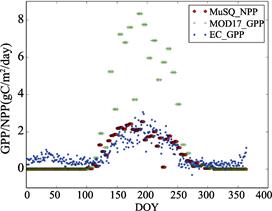
Figure 4 Comparison with the flux tower
observation data
|
The previous temporal resolution of Global 1 km NPP products is only yearly. It hinders the vegetation change studies in seasonal level. This data paper introduced a novel NPP model which took advantage of satellite network and used all available inputs to produce a 1 km/5-day NPP.
A trial production have been conducted in China-ASEAN for 2013 based on photosynthetically active radiation (PAR), photosynthetically active radiation ratio (FPAR), leaf area index (LAI), the maximum LUE , and land cover dataset. The preliminary validation using ground observation and previous NPP products showed that the new products had better accuracy and much better temporal resolution. More validations are planned to refine model in order to facilitate Global 1 km/5-day NPP production.
References
[1] Lieth, H. Primary production: terrestrial ecosystems [J]. Human Ecology, 1973, 1: 303-332.
[2] Field, C., Behrenfeld, M., Randerson, J., et al. Primary production of the biosphere: integrating terrestrial and oceanic components [J]. Science, 1998, 281: 237-240.
[3] Gao, S., Liu, Q. H., Kang, J., et al. 1 km/5-day net primary productivity product over China and the Association of Southeast Asian Nations for 2013 [DB/OL]. Global Change Research Data Publishing & Repository, 2015. DOI: 10.3974/ geodb.2015.01.15.V1.
[4] GCdataPR Editorial Office. GCdataPR Data Sharing Policy [OL]. DOI: 10.3974/dp.policy.2014.05 (Updated 2017).
[5] Goetz, S., Prince, S. Modeling terrestrial carbon exchange and storage: evidence and implications of functional convergence in light-use efficiency [J]. Advances in ecological research, 1999, 28: 57-92.
[6] Prince, S. D., Goward, S. N. Global primary production: A remote sensing approach [J]. Journal of
Biogeography, 1995, 22: 815-835.
[7] Schubert, S. D., Rood, R. B., Pfaendtner, J. An assimilated dataset for earth-science applications [J]. Bulletin of the American Meteorological Society, 1993, 74: 2331-2342.
[8] Li, S. H. Remote sensing monitoring of primary vegetation productivity based on data model fusion method [D]. Beijing: Institute of remote sensing applications, Chinese Academy of Sciences, 2007.
[9] Running, S., Nemani, R., Glassy, J., et al. MODIS daily photosynthesis (PSN) and annual net primary production (NPP) product (MOD17): algorithm theoretical basis document [R]. University of Montana, SCF At-Launch Algorithm ATBD Documents, 1999.