Elements and Magnetic Susceptibility Dataset
from the Lake Yamzhog Yumco Core in Southern Tibetan Plateau over the Past 2000
Years
Guo, C.1*
Ma, Y. Z.2 Li, J.
F.1
1. College of Resource Environment and Tourism, Hubei
University of Arts and Science, Xiangyang 441053, China;
2. Faculty of Geographical Science, Beijing Normal
University, Beijing 100875, China
Abstract: The chronology presented herein is based on 210Pb and
AMS 14C dates from a series of 50-cm sediment cores recovered from
the northwestern basin of Yamzhog Yumco lake on the southern Tibetan Plateau
using a Russian drill corer. Data for elemental geochemistry and magnetic
susceptibility were acquired using an X-ray fluorescence core scanner for in situ, high-resolution, continuous,
multi-element analyses. Multivariate numerical analyses (correlation analysis
and principal component analysis) were used to reconstruct how the environment
of the southern Tibetan Plateau has changed over the past 2000 years.
Temperature and precipitation reconstructions indicate that the Medieval Warm
Period was associated with low precipitation and high temperatures whereas the
Little Ice Age was associated with high precipitation and low temperatures. The
climate records from Yamzhog Yumco lake confirm a cold?Cmoist/warm?Cdry climate
pattern on the southern Tibetan Plateau over the past 2000 years. The lake
levels in the second millennium were generally higher than those in the first,
this being affected by both temperature and precipitation. The dataset is
archived in .xlsx format with a data size of 23 KB.
Keywords: Tibetan Plateau; Elemental
chemistry; Lake Yamzhog Yumco; Climate change
Dataset Availability Statement:
The dataset supporting this paper was published and is accessible
through the Digital
Journal of Global Change Data Repository at:
https://doi.org/doi:10.3974/geodb.2019.05.19.V1.
1 Introduction
The
climatic history of the past 2000 years is of great scientific interest for (i)
understanding future climate conditions and (ii) assessing present and future
human-induced climatic changes superimposed on natural trends[1].
For the southern Tibetan Plateau (TP), the climate changes in the region over
the past 2000 years are represented quantitatively in a dataset of the
intensity of major elements and magnetic susceptibility in cores from Yamzhog
Yumco (YY) lake[2]. Located at mid-to-low latitudes in the northern
hemisphere, the TP is among the areas most sensitive to climate change, and its
climate is controlled by interactions with large-scale atmospheric circulations,
including East Asian monsoons, Indian monsoons, and mid-latitude westerlies[3].
Unfortunately, most investigations to date have been restricted to the northern
sections of the TP[4?C6], and thus the climatic variations in the southern region over the past 2000 years remain
poorly known. The climate changes there have contrasting features, with the
precipitation or moisture records for different climatic regions occasionally
exhibiting opposing trends, which may indicate regional atmospheric circulation
from the associated topography. Therefore, a better understanding of how the
temperature-precipitation combination varies on different timescales would help
decipher the climatic processes and force mechanisms of natural climatic
variability. Variations in chemical elements and magnetic susceptibility in
lake sediment are controlled by various factors, such as physical and chemical
weathering processes, relative contributions to biogenic and regional climate
changes, and human activity[7]. The present dataset is helpful for
reconstructing the patterns of climate change in the southern TP over the past
2000 years, and it is important for a better understanding of the mechanisms of
climate change in monsoon areas at high elevation.
2 Metadata of the dataset
The
metadata for the ??Elements and magnetic susceptibility dataset from the Lake Yamzhog
Yumco core in Southern Tibetan Plateau over the past 2000 years??[2] is
summarized at Table 1, including the dataset full name, short name,
authors, year, data format, data size, data files, data publisher, and data
sharing policy, etc.
3 Methods
3.1 Data Sources
The raw data were sourced from
drilling the lake core and analyzing them in the laboratory. Four 50-cm
sediment cores were recovered from the lake basin using a Russian drill corer
(5-cm internal diameter), as shown in Figure 1. The lithologies in these
four sediment cores are well correlated. The sediment cores in PVC pipes were
transported to the laboratory, where they were described and subsampled shortly
thereafter. The chemical elements and magnetic susceptibility were determined
at 0.5-cm resolution using X-ray fluorescence core-scanning measurements. The
observations and grain-size analysis indicate that each core could be divided
stratigraphically into four major units from bottom to top, namely Sediment
Unit 1 (50?C40 cm; a gray-brown clay-silt layer), Sediment Unit 2
(40?C34 cm; a gray-white silt layer), Sediment Unit 3 (34?C13 cm; a
gray-brown clay-silt layer), and Sediment Unit 4 (13?C0 cm; characterized
by abundant plant roots and comprising Subunit 1 (13?C7 cm; a gray silt
layer), Subunit 2 (7?C5 cm; a gray-white fine sand layer) and Subunit 3
(5?C0 cm; a gray-white medium sand layer) (Figure 2).
Table 1 Metadata summary of the ??Elements
and magnetic susceptibility dataset from the Lake Yamzhog Yumco core in
Southern Tibetan Plateau over the past 2000 years??
|
Items
|
Description
|
|
Dataset
full name
|
Elements
and magnetic susceptibility dataset from the Lake Yamzhog Yumco core in
Southern Tibetan Plateau over the past 2000 years
|
|
Dataset
short name
|
Elem&MS_YamzhogYumco_p2000
|
|
Authors
|
Guo,
C. AAF-6180-2019, College of Resource Environment and Tourism, Hubei University
of Arts and Science, gc@mail.bnu.edu.cn
Ma,
Y. Z. AAF-6498-2019, Faculty of Geographical Science, Beijing Normal
University, mayzh@bnu.edu.cn
Li,
J. F., College of Resource Environment and Tourism, Hubei University of Arts
and Science, 11650@hbuas.edu.cn
|
|
Geographical
region
|
Southern
Tibetan Plateau
|
|
Year
|
0-2000AD
|
|
Data
format
|
.xlsx
|
|
|
|
Data
size
|
23 KB
|
|
|
|
Data
files
|
The
chronology, elements and magnetic susceptibility sequence during the past
2000 years
|
|
Foundations
|
Ministry
of Science and Technology of P. R. China (2013CB956001); National Natural
Science
Foundation
of China (41571186, 41330748)
|
|
Data
publisher
|
Global Change Research Data Publishing &
Repository, http://www.geodoi.ac.cn
|
|
Address
|
No.
11A, Datun Road, Chaoyang District, Beijing 100101, China
|
|
Data sharing policy
|
Data from the Global Change
Research Data Publishing &Repository includes metadata, datasets (in the Digital Journal of Global Change Data Repository), and
publications (in the Journal of Global Change Data & Discovery). Data
sharing policy includes: (1) Data are openly available
and can be free downloaded via the Internet; (2) End users are encouraged to
use Data subject to cita-tion; (3) Users, who are by definition
also value-added service providers, are welcome to redistribute Data subject
to written permission from the GCdataPR Editorial Office and the issuance of
a Data redistribution license; and (4) If Data are
used to compile new datasets, the ??ten per cent principal?? should be followed
such that Data records utilized should not surpass 10% of the
new dataset contents, while sources should be clearly noted in suitable places
in the new dataset[8]
|
|
Communication and searchable system
|
DOI??DCI??CSCD??WDS/ISC??GEOSS??China
GEOSS??Crossref
|
|
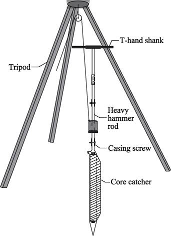
Figure 1 The diagram of Russian drill corer[9]
|
3.2 Algorithm
Principle
Based on previous environmental
interpretations for different element indices, we used correlation analysis
(CA) and principal component analysis (PCA) to summarize and classify the
chemical elements and determine their environmental meanings.
3.2.1 Correlation
Analysis
CA
was performed to discern similarities throughout the entire set of proxies. The
correlation of elements is controlled by the geochemical behavior in the epigenetic
environment, and the CA of different elements can reveal the associated
relationships among them and identify their possible sources[11]. A
higher correlation among chemical elements produces a larger correlation coefficient.
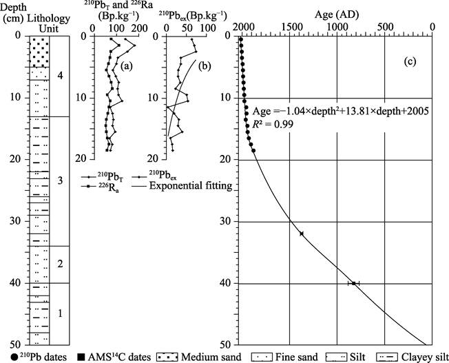
Figure 2 Stratigraphy and
chronology of Lake Yamzhog Yumco core[10]
3.2.2 Principal Component Analysis
PCA can describe objectively the main factors that control
the elemental composition of sediments. This approach was chosen to provide a
two-dimensional representation of high-dimensional geometric distances between
each element as defined in transect. PCA has been used frequently for elemental
analysis because it is easily implemented on large datasets and the results can
be displayed graphically[12].
4 Data Results
and Validation
4.1
Data Composition
The dataset includes (i) 210Pb
activities at 1-cm intervals from the top 19 cm, (ii) two AMS 14C
dates obtained from 32?C40 cm, and (iii) chemical elements and magnetic susceptibility
data at 0.5-cm resolution from the lake cores.
4.2
Data Results
4.2.1 Chronology
The final age-depth model was generated based on the 210Pb
and AMS 14C dates using a second-order polynomial regression
model with 95% significance as determined using the p value. The results from the model were then used to extrapolate
the age of the bottom samples as being approximately 100 AD, and the
chronology of the YY lake core was established over the past 2000 years (Figure 2).
4.2.2 Correlation Analysis
Although the elements demonstrate several correlations,
three particular groups are observed, namely (i) Si, K, and Ti; (ii) Fe, Cu,
Zn, and Pb; and (iii) Ca and Sr. Note that the correlation characteristics of
Al, Y, Rb, and Zn are not significant and have obvious transitional characteristics,
thus they are not included in the following discussion.
4.2.3 Principal Component Analysis
The PCA results show that the first three eigenvectors
account for 82.9% of the total variance. The first eigenvector represents 47.3%
of the total variance and displays high positive scores for Si, K, and Ti. The
second eigenvector accounts for 23.8% of the total variance and is
characterized by high positive scores for Br and Pb, and to lesser extents Fe
and Cu. The third eigenvector accounts for 11.9% of the total variance and
shows high positive scores for Ca and Sr at the positive end (Figure 3).
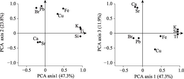
Figure
3 Major elements from Lake
Yamzhog Yumco core[10]
The
PCA confirms the inferences observed previously using CA. First, Si, K, and Ti
contribute to the first eigenvector, thereby suggesting that they have a common
origin. This is likely related to their occurrence in terrigenous detrital
minerals and can represent precipitation in the catchment[11].
Second, Fe, Pb, Cu and Br contribute to the second eigenvector, which is likely
due to the influence of redox conditions in the deposition[13]. Note
that the high correlation of Br may be because it is controlled by temperature[14].
Third, the strong correlation between Ca and Sr in the third group suggests
that the record contains carbonate deposition. Ca and Sr in lake sediments are
related to carbonate weathering in the catchment and in-lake deposition of CaCO3
with the co-deposition of SrCO3, which increases with heightening water
level of lake.
4.2.4 Environmental Variations over Past 2000 Years
The robust chronology and high-resolution chemical elements and magnetic susceptibility sequences[10]
allow us to reconstruct the history of climate variations over the past 2000
years in the study area. In addition, the magnetic susceptibility has been
discussed widely as an effective indicator of precipitation changes in the
basin[16]. Finally, we select Ti, Si, K, and magnetic susceptibility
from which to reconstruct the precipitation changes in the YY lake basin. The
strengths of Br, Fe, Cu, and Pb indicate changes in temperature, and the
strengths of Ca, Sr and Ca/Fe indicate changes in the lake level. The records
from YY lake confirm a cold-moist/warm-dry climate pattern in the southern TP
over the past 2000 years. During the Medieval Warm Period (800?C1200 AD), the strengths of Si,
K, and Ti and the magnetic susceptibility were relatively high whereas the
strengths of Br, Fe, Cu, and Pb were relatively low, thereby suggesting a dryer
climate associated with low precipitation and high temperatures. In contrast,
during the Little Ice Age (1200?C1900 AD),
the simultaneous increases in Si, K, Ti, and magnetic susceptibility and the
dramatic decreases of Br, Fe, Cu, and Pb reveal humid climate conditions with
high precipitation and low temperatures. Moreover, given the effects of
temperature and precipitation, the lake levels in the second millennium were
generally higher than those in the first (Figure 4).
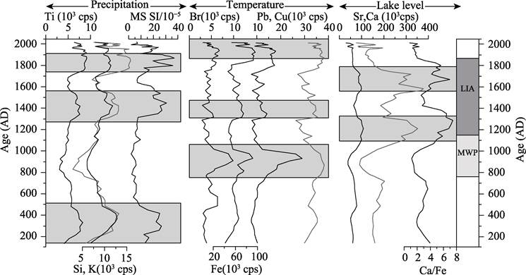
Figure 4 Reconstruction
of the environmental conditions (precipitation, temperature, water level) of
Lake Yamzhog Yumco catchment during the past 2000
years[10] (MWP: Medieval Warm
Period; LIA: Little Ice Age)
4.3 Data validation
We assessed the validity of the
chemical-element indices of temperature, precipitation, and lake-level proxies based on a Pearson correlation test between the strength of elements
on top of the lake cores and modern instrumental records
from nearby hydrological stations[17],
|
Table 2 Pearson-correlation test between
major elements and modern
instrument records
|
|
Element
|
MAP
|
MAT
|
Lake level
|
|
Ti
|
0.69**
|
|
|
|
K
|
0.68**
|
|
|
|
Br
|
|
0.79**
|
|
|
Fe
|
|
0.73**
|
|
|
Ca
|
|
|
0.75**
|
|
**
At 0.01 level (double side)
|
as given in Table 2. The
intensities of Ti and K have higher correlations with the mean annual
precipitation (MAP), with R values
reaching 0.69 and 0.79, respectively, and passing the double-sided test at a
0.01 confidence interval. Analogously, the intensities of Br and Fe have
higher correlations with the mean annual temperature (MAT), with R values reaching 0.79 and 0.73,
respectively, and passing the double-sided test at a 0.01 confidence interval.
In addition, the strength of Ca is correlated well with the lake level (R = 0.75 and at 0.01 level
double side). Therefore, it is considered that changes in the chemical elements
in
the YY lake cores are effective for reflecting past environmental changes
in the southern TP.
5 Discussion
and Conclusion
The southern TP is located at
the southwest end of mainland China and is influenced more strongly by the
Indian summer monsoon than are the northern parts of the TP. Thus, the volatility
and differences in climate change are more pronounced. Based on lake records
from the southern TP, a robust chronology was used
as the framework, and various mathematical and statistical methods were used to
reconstruct a high-resolution environmental-change model of the southern TP
over the past 2000 years based on records of major elements and magnetic
susceptibility. The data validations suggest that variations in the major
elements in YY lake cores are effective for reflecting past environmental
changes. These results provide a reference for exploring the response of global
climate change in the southern TP over the past 2000 years.
Author
Contributions
Ma, Y. Z., designed the algorithms of
dataset. Guo, C., contributed to the data processing and analysis. Li, J. F.,
wrote the data paper.
References
[1]
Anderson, D. M., Overpeck, J. T., Gupta, A. K. Increase
in the Asian Southwest Monsoon during the past four centuries [J]. Science, 2002, 297(5581): 596‒599.
[2]
Guo, C., Ma, Y. Z. Elements and magnetic
susceptibility dataset from the Lake Yamzhog Yumco core in Southern Tibetan
Plateau over the past 2000 years [J/DB/OL]. Digital Journal of Global Change Data Repository,
2019. https://doi.org/10.3974/geodb.2019.05.19.V1.
[3]
Wang, Y., Liu, X., Herzschuh, U.
Asynchronous evolution of the Indian and East Asian Summer Monsoon indicated by
Holocene moisture patterns in monsoonal central Asia [J]. Earth-Science Reviews, 2010, 103(3): 135‒153.
[4]
Qiang, M., Chen, F., Zhang J., et al. Climatic
changes documented by stable isotopes of sedimentary carbonate in Lake Sugan,
northeastern Tibetan Plateau of China since 2 ka BP [J]. Chinese Science
Bulletin, 2005, 50(13): 1385‒1393.
[5]
Liu, Z., Henderson, A. C. G., Huang, Y. Alkenone-based
reconstruction of Late-Holocene surface temperature and salinity changes in
Lake Qinghai, China [J]. Geophysical
Research Letters, 2006, 33(13): 370‒386.
[6]
Liu, X., Dong, H., Yang, X., et al. Late Holocene forcing of the Asian winter and summer monsoon
as evidenced by proxy records from the northern Qinghai-Tibetan Plateau [J]. Earth & Planetary Science Letters, 2009, 280(1/4): 276‒284.
[7]
Weltje, G. J., Tjallingii, R. Calibration of XRF core
scanners for quantitative geochemical logging of sediment cores: theory and
application [J]. Earth & Planetary Science Letters, 2008,
274(3/4): 423‒438.
[8]
GCdataPR Editorial Office. GCdataPR data sharing policy
[OL]. https://doi.org/10.3974/dp.policy.2014.05 (Updated 2017).
[9]
Ma, Y. Z., Guo, C., Meng, H. W., et al. A lake
sediments drill corer with different depths of water [P]. China Patent: ZL 201310194186.4.
[10]
Guo, C., Meng, H. W., Ma, Y. Z., et al.
Environmental variations recorded by chemical element in the sediments of Lake
Yamzhog Yumco on the southern Tibetan Plateau over the past 2000 years [J]. Acta
Geographica Sinica, 2019, 74(7): 1345‒1362.
[11]
Kylander,
M. E., Ampel, L., Wohlfarth, B., et al.
High-resolution X-ray fluorescence core scanning analysis of Les Echets (France)
sedimentary sequence: new insights from chemical proxies [J]. Journal of Quaternary Science, 2011,
26(1): 109‒117.
[12]
Wold, S.,
Esbensen, K., Geladi, P. Principal component analysis [J]. Chemometrics & Intelligent
Laboratory Systems, 1987, 2: 37‒52.
[13]
Morell??n,
M., Valero-Garc??s, B., Vegas-Vilarr??bia, T., et al. Lateglacial and Holocene palaeohydrology in the western Mediterranean
region: the Lake Estanya record (NE Spain) [J]. Quaternary Science Reviews, 2009, 28(25): 2582‒2599.
[14] Ziegler,
M., Jilbert, T., De Lange, G. J., et al.
Bromine counts from XRF scanning as an estimate of the marine organic carbon
content of sediment cores [J]. Geochemistry
Geophysics Geosystems, 2008, 9(5): 303‒307.
[15]
Jin, Z.,
Cao, J., Wu, J., et al. A Rb/Sr
record of catchment weathering response to Holocene climate change in Inner Mongolia
[J]. Earth Surface Processes & Landforms, 2006, 31(3): 285‒291.
[16]
Dearing, J.
A. Holocene Environmental Change from Magnetic Proxies in Lake Sediments [M]. //
Quaternary Climates, Environments and Magnetism, Maher, B. A., Thompson, R.
(eds.). Cambridge: Cambridge University Press, 1999: 231‒278.
[17]
Chu, D., Pu, Q., Wang, D., et al. Water level
variations of Yamzho Yumco Lake in Tibet and the main driving forces [J]. Journal
of Mountain Science, 2012, 30(2): 239‒247.