Elevation Cluster Dataset Covering the Yenisei River Basin
Yang, A. Q.1* Liu, C.2 Shi, R. X.2
1. Institute of Remote Sensing and Digital Earth, Chinese Academy of Sciences, Beijing 100101, China;
2. Institute of Geographic Sciences and Natural Resources Research, Chinese Academy of Sciences, Beijing 100101, China
Abstract: Elevation Cluster Dataset Covering the Yenisei River Basin (YeniseiRBasinEVC for short) is a raster data with 30m resolution on land elevation cluster in the Yenisei River Basin based on the data integration among the Aster-GDEM, Google Earth elevation data and the boundary data of the Yenisei River Basin. 10 classes of land elevation levels are identified from less than 50 meters above sea level to more than 3,000 meters. In the Yenisei River Basin, most of the area is mountain and the plateau. The area with the elevation lower than 200 m in north Yenisei River Basin belongs to West Siberian Plain and North Siberian Lowland. The middle and south parts belong to Central Siberian Plateau and Sayan Mountains. The data is archived in .tif format with the compressed data size of 115 MB.
Keywords: Yenisei river basin; elevation cluster dataset; Central Siberian Plateau; West Siberian Plain
1 Introduction
The Yenisei is the largest river system flowing to the Arctic Ocean[1]. The Yenisei River contributes 630 km3 freshwater per year, which is about 22% of total freshwater flow into the Arctic Ocean[2]. Fresh water discharge from northern-flowing rivers in the polar regions plays an important role in regulating the thermohaline circulation of the world’s oceans[3]. The Yenisei River is also the boundary between the West Siberian Plain and the Central Siberian Plateau. The Elevation Cluster Dataset is one of the basic data for studying the Yenisei Basin. This dataset is produced based on the data integration among the Aster-GDEM and Google Earth elevation data. According to the terrain characteristic of Yenisei River Basin[4–6], the cluster of the elevation was divided into ten intervals.
2 Metadata of dataset
The descriptions of the Elevation Cluster Dataset Covering the Yenisei River Basin are recorded. These information include the dataset full name, dataset short name, authors, geographical regions of the dataset content, year of the dataset, spatial resolution, data format and size, data files, data publisher, and the data sharing policy. Table 1 summarizes metadata elements of the dataset.
Table 1 Summary of the YeniseiRBasinEVC metadata
|
Items
|
Description
|
|
Dataset full name
|
Elevation cluster dataset covering the Yenisei River Basin
|
|
Dataset short name
|
YeniseiRBasinEVC
|
|
Authors
|
Yang, A. Q. J-6978-2017, Institute of Remote sensing and Digital Earth, Chinese Academy of Sciences, gis98@163.com
Liu, C. L-3684-2016, Institute of Geographic Sciences and Natural Resources Research, Chinese Academy of Sciences, lchuang@igsnrr.ac.cn
Shi, R. X. L-4389-2016, Institute of Geographic Sciences and Natural Resources Research, Chinese Academy of Sciences, shirx@igsnrr.ac.cn
|
|
Geographical region
|
46°27ʹ28ʺ N-73°38ʹ24ʺN, 73°37ʹ43ʺE-113°50ʹ53ʺE
|
|
Year
|
2001-2011
|
|
Spatial resolution
|
30 m
|
|
Data format
|
.tif, .xlsx
|
|
|
|
Data size
|
115 MB
|
|
|
|
Data files
|
The dataset consists of 2 files. They are
1. YeniseiRBasinEVC.rar, this is the Elevation Cluster data. Data size is 115 MB
2. Sta_YeniseiRBasinEVC.xlsx, this is the statistic file. Data size is 0.2 KB
|
|
Data publisher
|
Global Change Research Data Publishing & Repository, http://www.geodoi.ac.cn
|
|
Address
|
No. 11A, Datun Road, Chaoyang District, Beijing 100101, China
|
|
Data sharing policy
|
Data from the Global Change Research Data Publishing & Repository includes metadata, datasets (data products), and publications (in this case, in the Journal of Global Change Data & Discovery). Data sharing policy includes: (1) Data are openly available and can be free downloaded via the Internet; (2) End users are encouraged to use Data subject to citation; (3) Users, who are by definition also value-added service providers, are welcome to redistribute Data subject to written permission from the GCdataPR Editorial Office and the issuance of a Data redistribution license; and (4) If Data are used to compile new datasets, the ‘ten per cent principal’ should be followed such that Data records utilized should not surpass 10% of the new dataset contents, while sources should be clearly noted in suitable places in the new dataset[5]
|
3 Materials and Methods
3.1 The Study Area
The Yenisei River Basin is mainly in Russia except a little south part belonging to Mongolia. In the Yenisei River Basin, most of the area is in the mountain and the plateau. The area with the elevation lower than 200 m in north Yenisei River Basin belongs to West Siberian Plain and North Siberian Lowland. The middle and south parts belong to Central Siberian Plateau and Sayan Mountains. The Yenisei River flows to Arctic Ocean from the south to north. The Yenisei River Basin (46°27ʹ28ʺN-73°38ʹ24ʺN, 73°37ʹ43ʺE-113°50ʹ53ʺE) cover the area with 2.66×10⁶ km2. Figure 1 shows tiles of the YeniseiRBasinEVC.
3.2 Material and Preprocessing
The ASTER GDEM2 data was used as the main data source. Based on the boundary of Yenisei
River Basin[7], a total of 534 GDEM2 data were selected, mosaicked and clipped.
|
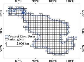
Figure 1 Tiles of the YeniseiRBasinEVC
|
ASTER GDEM2 was released on
October 17th, 2011. Compared to the
first edition, the spatial resolution was improved, and the horizontal accuracy, vertical accuracy and water body elevation accuracy also improved. ASTER GDEM2 data cover land surface between south latitude 83° and north latitude 83°, with pixel resolution of 1 arc sec. The overall height accuracy of the ASTER GDEM2 is 17 m at the 95% confidence level and the horizontal position accuracy is about 75 m. Although GDEM2 has a lot of quality improvement compared to the first edition, the data have some anomalies in some areas with serious cloud interference. In order to correct these data anomalies, the Google Earth Digital Elevation Model is extracted to compensate for the outliers on GDEM2 data. Figure 2 and Figure 3 show the data anomalies (left) of ASTER GDEM2 and noisy free data (right).
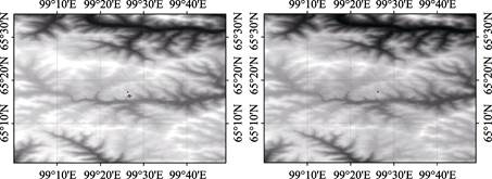
Figure 2 The data anomalies and fixes
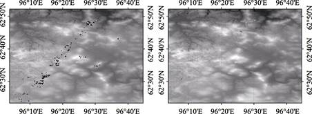
Figure 3 The data anomalies and fixes
3.3 Cluster of the Elevation
According to the topography characteristics of Yenisei River Basin, a total of 10 elevation
clusters were developed (Table 2). In order to reflect the distribution characteristics of
|
Table 2 The statistics of the Elevation Cluster Dataset
|
|
Elevation(m)
|
Code
|
Area (Km2)
|
Percentage (%)
|
|
<50
|
1
|
165,096
|
6.21
|
|
50-100
|
2
|
99,342.68
|
3.74
|
|
100-200
|
3
|
171,111.65
|
6.43
|
|
200-500
|
4
|
975,181.73
|
36.66
|
|
500-1,000
|
5
|
570,176.31
|
21.44
|
|
1,000-1,500
|
6
|
326,271.46
|
12.27
|
|
1,500-2,000
|
7
|
229,489.35
|
8.63
|
|
2,000-2,500
|
8
|
101,429.26
|
3.81
|
|
2,500-3,000
|
9
|
20,106.33
|
0.76
|
|
>3,000
|
10
|
1,514.09
|
0.06
|
|
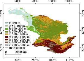
Figure 4 The elevation cluster dataset of
the Yenisei River Basin
|
low-altitude areas, elevation less than 500 m was divided into four intervals. The elevation more than 3,000 m was divided as a single interval. The rest elevation from 500 m to 3,000 m was divided by an interval of 500 m. The Elevation Cluster Dataset Covering the Yenisei River Basin shows that the lowland area lower than 500 m is 1.65×10⁵ km2, accounting 6.21% of the basin area; the area with elevation from 50 to 100 m is 9.93×10⁴ km2 accoun-
ting 3.74% of the basin area; the land with elevation between 100 m and 200 m is 1.71×10⁵ km2, about 6.43% of the total area of the basin. In Yenisei River Basin, the main part with area 9.75×10⁵ km2 locates between 200 m and 500 m, which accounts about 36.66% of the basin;the land with elevation between 500 m and 1,000 m is 5.70×10⁵ km2, 12.27% of total area of the basin. The mountain land more than 1,500 m above sea level accounts 13.26% of the basin area. The dataset was archived as .tif file with 112 MB compressed data size. The Elevation Cluster Dataset Covering the Yenisei River Basin is shown in Figure 4,and the statistics value is shown in Table 2.
4 Dataset Composition
The dataset consists of 2 files. They are:
(1). YeniseiRBasinEVC.rar, this is the elevation cluster data covering the Yenisei River Basin, which was archived in .tif data format, with 115 MB compressed data size. In this data, the codes and their elevations were shown in Table 2.
(2). Sta_YeniseiRBasinEVC.xlsx, this is the statistic file. Data size is 0.2 KB.
5 Discussion and Conclusion
The elevation cluster dataset is the basic data for learning the Yenisei River Basin. Based on the dataset, the overall characteristics of the basin could be grasped. The Elevation Cluster Dataset Covering the Yenisei River Basin indicates that most area of the Yenisei River Basin is located in mountainous and plateau areas. The northern plains of the Yenisei River (the western Siberian plain) and the lowlands (the northern Siberian lowlands) account for 9.95% of the basin area, the middle basin is the Central Siberian Plateau, and the Sayan and Tannu-Ola mountains locate at the south of the basin. The overall terrain presents a south-north low-lying situation, that is, low-latitude with high altitude, high altitude with low altitude. Yenisei River flows into the Kara Sea of Arctic Ocean from the Sayan Mountain and Tannu-Ola Mountain. It can be seen from the Elevation Cluster Dataset that the upper reaches of the Yenisei River are deep in the valley and the valley of the middle reaches change wide out of Sayan and Tannu-Ola mountains. The river catches water through the Central Siberian Plateau and flows to downstream. Downstream terrain is more flat, and a typical delta formed in the sea port.
Author Contributions
Yang A. Q. produced the dataset and wrote the manuscript. Liu, C. and Shi, R. X. contributed to the elevation classification, data quality inspection and manuscript review.
References
[1] Bobrovitskaya, N. N., Zubkova, C., Meade, R. H. Discharges and yields of suspended sediment in the Ob and Yenisey Rivers of Siberia [J]. IAHS-AISH Publication, 1996, 236: 115-123.
[2] Grabs, W. E., Fortmann, F., Couuel, T. D. Discharge Observation Oetworks in Arctic Regions: Computation of the River Runoff into the Arctic Ocean, its Seasonality and Variability [M]. In: Lewis, E. L., et al. (eds). The Freshwater Budget of the Arctic Ocean. Kluwer Academic Publishers, 2000, 249-267.
[3] Aagaard, K. Carmack, E. C. The role of sea ice and other fresh water in the arctic circulation [J]. Journal of Geophysical Research, 1989, 94 (C10): 14485-14498.
[4] ASTER GDEM 2 Readme. Advanced Spaceborne Thermal Emission and Reflection Radiometer (ASTER) Global Digital Elevation Model (GDEM) Version 2 [Z]. 2011
[5] Tachikawa, T., Hato, M., Kaku, M., et al. The characteristics of ASTER GDEM version 2 [A]. IGARSS, 2011.
[6] ASTER GDEM Validation Team. ASTER Global Digital Elevation Model Version 2―summary of validation results [Z]. 2011.
[7] Yang, A. Q., Liu, C., Shi, R. X. Elevation Cluster Dataset Covering the Yenisei River Basin [DB/OL]. Global Change Research Data Publishing & Repository, 2016. DOI: 10.3974/geodb.2016.07.20.V1.
[8] GCdataPR Editorial Office. GCdataPR Data Sharing Policy [OL]. DOI:10.3974/dp.policy.2014.05 (Updated 2017).
[9] Huang, Y. F., Li, T. J., Lv, E. Z., et al. Boundary Data of the Yenisei River Basin [DB/OL]. Global Change Research Data Publishing & Repository, 2016. DOI:10.3974/geodb.2016.05.03.V1.