Global Change Data Encyclopedia
Flannan Isles, United Kingdom
Liu, C.* Shi, R. X.
Institute of Geographic Sciences and Natural Resources Research, Chinese Academy of Sciences, Beijing 100101, China;
|

Figure 1 Geo-location of Flannan Isles (.kmz format)
|
Keywords: Flannan Isles; United Kingdom; Scotland; Eilean Mor Isle; data encyclopedia
Flannan Isles, also called Seven Hunters[1], is an isle group of Outer Hebrides[2] of Scotland. Its geo-location is 58°16′18″N-58°17′23″N, 7°33′32″W-7°39′19″W[3] (Figures 1-2).
The Flannan Isles is consisted of a series of small isles, including Eilean Mor Isle and Eilean Tai ghe Isle in the northeast, Soray Isle, Sgeir Tomain Isle, and Righinn Sgeir Isle in the south, and Roareim Isle, Eilean Gobha Isle, and Brona Cleit Rock in the west.
|
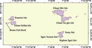
Figure 2 Geo-location of Flannan Island (.shp format)
|
In 1899, the lighthouse and its facilities of the Flannan Isles were built on the Eilean Mor Isle by the United Kingdom. The geo-location of the lighthouse is 58°17.294′N, 7°35.394′W and it is 23 m high[4]. In 1983, it was listed as the Site of Special Scientific Interest for protection and utilization by the United Kingdom.
The total area of the Flannan Isles is 0.62 km2, and the coastline is 15.98 km. Among the isles, the biggest isle is Eilean Mor Isle, whose area is 0.18 km2[3]. The highest point is 88 m above sea level on the Eilean Mor Isle.
The dataset was developed based on the ArcGIS[5], Google Earth images and the thematic maps of Scotland. The dataset is archived in both .kmz and .shp data formats, consisting 15 data files with data size of 543 KB (compressed to two data files, 212 KB).
Table 1 List of main islands in the Flannan Isles
|
Name of island
|
Geo-location
|
Center location
|
Area (m2)
|
Coastline (m)
|
|
Eilean Mòr Isle
|
58º17′10″N-58º17′23″N,
7º35′45″W-7º35′5″W
|
58º17′15″N,
7º35′15″W
|
179,016
|
2,775
|
|
Eilean Tai ghe Isle
|
58º16′55″N-58º17′7″N,
7º35′19″W-7º34′33″W
|
58º17′2″N,
7º35′0″W
|
125,073
|
2,271
|
|
Eilean Gobha Isle
|
58º16′47″N-58º16′57″N,
7º38′57″W-7º38′34″W
|
58º16′53″N,
7º38′46″W
|
71,436
|
1,219
|
|
Roareim Isle
|
58º16′58″N-58º17′8″N,
7º39′1″W-7º38′42″W
|
58º17′4″N,
7º38′51″W
|
53,486
|
1,352
|
|
Soray Isle
|
58º16′26″N-58º16′34″N,
7º35′28″W-7º35′6″W
|
58º16′30″N,
7º35′16″W
|
45,700
|
990
|
|
Sgeir Tomain Isle
|
58º16′20″N-58º16′26″N,
7º35′33″W-7º35′12″W
|
58º16′23″N,
7º35′23″W
|
34,761
|
842
|
|
Righinn Sgeir Isle
|
58º16′18″N-58º16′23″N,
7º35′25″W-7º35′9″W
|
58º16′22″N,
7º35′13″W
|
15,179
|
641
|
|
Bròna Cleit Rock
|
58º16′51″N-58º16′54″N,
7º39′19″W-7º39′12″W
|
58º16′52″N,
7º39′16″W
|
7,460
|
330
|
|
Others
|
|
|
88,381
|
5,563
|
|
Flannan Isles
|
58°16′18″N-58°17′23″N??7°33′32″W-7°39′19″W
|
|
620,492
|
15,983
|
References
[1] Flannan Isles [OL]. https://en.wikipedia.org/wiki/Flannan_Isles.
[2] Field Enterprises Educational Corporation. The World Book Encyclopedia (Volume 9) [M]. Chicago: Field Enterprises Educational Corporation, 1976: 155.
[3] Liu, C., Shi, R. Flannan Isles [DB/OL]. Global Change Research Data Publishing & Repository, 2017. DOI: 10.3974/geodb.2017.01.02.V1.
[4] List of lighthouses in Scotland [OL]. https://en.wikipedia.org/wiki/List_of_lighthouses_in_Scotland.
Data Computing Environment
[5] ESRI. ArcGIS campus license of the Institute of Geographic Sciences and Natural Resources Research, Chinese Academy of Sciences.
URL for Data Downloading
http://www.geodoi.ac.cn/WebEn/doi.aspx?Id=634.
Or search though: http://www.geodoi.ac.cn.