GIS Dataset of Boundaries among Four Geo-eco Regions of China
Liu, C.* Shi, R. X.
Institute of Geographic Sciences and Natural Resources Research, Chinese Academy of Sciences, Beijing 100101, China
Abstract: Based on geo-ecosystem data analysis in Asia-Oceanic region, four geo-ecosystem regions of China were identified according to the theory of comprehensive geography, critical indexes method and multiple geographical data, they are: Eastern monsoon region, Northwest arid and semi-arid region, Qinghai-Tibetan Plateau region and Southern tropic islands region. The vector data in both .kmz and .shp formats in meters resolution was developed. The dataset indicated that the most large region in Eastern monsoon region (account for 44.69 % of total area of China), the Northwest arid and semi-arid region, the Qinghai-Tibetan Plateau region and the Southern tropic islands region follow with 24.53 %, 30.02 % and 0.76 % of the total land of China. The dataset is consisted of 15 data files with the data size of 52.9 MB at .shp and .kmz data formats, which was compressed into 2 data files with the data size of 37.3 MB.
Keywords: China; geo-ecosystem region; regionalization; boundary data; integrated geography
1 Introduction
Geo-ecosystem regionalization is one of key methods for identifying and understanding the differences among regions, it is basic and important filed for geographical studies[1]. Since 1930’s, geographers recognized its importance for geographical studies of China, a new milestone of geo-ecosystem regionalization in both theoretical and practical dimensions since 1950’s[2–5]. Moreover, the studies on geo-ecosystem regionalization of China come to the digital studies since the 21st century[6], it becomes the necessary knowledge and foundations for the regional studies of artificial intelligence, machine learning and data mining.
2 Comparison of Historical Geo-ecosystem Regionalization of China
2.1 Historical Geo-ecosystem Regionalization of China since 1950’s
Several major systems for geo-ecosystem regionalization of China were published since 1950’s (Table 1).
In 1954, Professors Lin et al. published the Lin’s system of the Integrated Physical Geographical Regionalization of China, which was mainly used for geographical education in universities[3]. In Lin’s system, 5 regional levels were hierarchical identified, including Eastern China and Western China in the first level, 4 regions in the second level, 10 sub-regions in the third level, 31 areas in the fourth level and 105 sub-areas in the fifth level ( 8 regions and 36 sub-regions were amended in 1957 by Ministry of Education of China) [3]. In 1954, Professor Luo, K. F. published the Luo’s system, which was for the geographical record program of China. Similar with Lin’s system, Eastern China and Western China in the first level were identified in Luo’s system, and then two more levels were divided, including 7 regions in the second level and 22 sub-regions in the third level[4].
In 1959, Professor Hang, B. W. led the program of the Integrated Physical Geographical Regionalization of China, which was the largest program since 1930’s and more than a hundred of geographers jointed the three years program. In Huang’s system[5], 7 levels of regional classification system of China were identified, including 3 large regions in the first level (Easter Monsoon Region, Northwest Arid and Sub-arid Region and Qinghai-Tibetan Plateau Region), and then 6 temperature zones in the second level, 18 regions and sub-regions in the third and forth levels, 28 areas and sub-areas in the fifth and sixth levels and 90 provinces in the seventh level. In 1961, Professor Ren, M. E. proposed a new system with difference opinions from Huang. Four levels of regions in Ren’s system, including 8 regions in the first level (Northeast of China, North of China, Mid of China, South of China, Southwest of China, Northwest of China, Inner Mongolia and Qinghai-Tibet), 23 districts in the second level, 68 provinces in the third level. The fourth level of regions called as prefectures [7-8]. In 1963, Professor Hou, X. Y. published a two levels classification system, in which, 6 zones and 1 region were identified in the first level, including temperature zone, warm temperature zone, semi-subtropical zone, subtropical zone, semi-tropical zone, tropical zone and Qinghai-Tibet region, and 29 sub-regions in the second level[9].
In 1983, Professor Zhao published a five levels classification system of geo-ecosystem regionalization of China. In Zhao’s system, 3 large regions in the first level, 7 natural regions in the second level, 33 districts in the third level and sub-regions and areas in the fourth and fifth levels had been identified. In this system, Huang’s system in the first level in 1959 was adopted to divide China into three regions (Easter Monsoon Region, Northwest Arid and Sub-arid Region and Qinghai-Tibetan Plateau Region)[10]. In 1984, National Agriculture Regionalization Committee published the Framework of Natural Regionalization of China, in which, three levels of geo-ecosystem classification system was proposed, including 3 large regions in the first level (Easter monsoon region, Northwest Arid and Sub-arid region and Qinghai-Tibetan Plateau region), 14 zones and 44 regions, all the boundaries were based on the administrative boundaries in the county level[11]. In 1988, Professor Hou proposed another system including 6 zones and 20 sub-regions[12].
In 1994, Professor Ni published a three levels classification system of geo-ecosystem regionalization of China. In which, 8 regions, 30 sub-regions and 71 areas had been identified[13]. In 1999, Professors Yang and Zheng proposed a three levels regionalization system, including 11 temperature zones, 21 regions and 49 sub-regions of geo-ecosystem of China[1,14–15]. In 2001, Professor Liu and Fu published a geo-ecosystem of China, including 3 large regions, 13 regions and 57 sub-regions[16–18].
Besides, a series of regionalization systems on geo-ecosystem of China were published, they are: Huang[19] (1999, Ecosystem Product Regionalization of China), Ouyang [20] (2000, Ecosystem and Environment Sensitive Regionalization of China), Miao[21] (2001, Ecosystem and Environment Pressure Regionalization of China), Xu[22] (2001, Ecosystem Productivity Regionalization of China), Ni[23] (1998, Bio-diversity Regionalization of China), Xie[24] (2002, Bio-system Regionalization of China), Wang[25] (2000, Agriculture Disaster Regionalization of China), Fan and Luo[26] (2015, Main Function Regionalization of China), Wu Shaohong[27] (2017, Climate Change Risk Regionalization of China), Fang[28](2017, Regionalization for Human Geography of China) and more.
2.2 Groups of Thought in Geo-ecosystem Regionalization of China
Summarizing the systems of above, there are four groups of thought in understanding the geo-ecosystem regionalization of China in the first level, they are: group of thought on Eastern and Western China, group of thought on three large regions (Easter Monsoon Region, Northwest Arid and Sub-arid Region and Qinghai-Tibetan Plateau Region), group of thought on 6-8 regions and group of thought on temperature zones (Table 2).
Table 1 Comparison among the systems of geo-ecosystem regionalization of China
|
Group of Thought
|
Author
|
Classification System
|
Year Published
|
|
2 parts: Eastern and Western China
|
Lin, C.
|
2 parts–4 regions–10 sub-regions–31 areas–105 sub-areas
|
1954[3]
|
|
Luo, K. F.
|
2 parts–7 regions–22 sub-regions
|
1954[4]
|
|
3 large regions: Easter Monsoon Region, Northwest Arid and Sub-arid Region and Qinghai-Tibetan Plateau Region
|
Huang, B. W
|
3 large regions–6 temperature zones–18 regions and sub-regions–28 areas and sub-areas–90 provinces
|
1959[5]
|
|
Zhao, S. Q.
|
3 large regions–7 regions–33 districts
|
1983[10]
|
|
National Agriculture Regionalization Committee
|
3 large regions–14 zones and 44 regions
|
1984[11]
|
|
Liu, G. H., Fu, B. J., et al.
|
3 large regions–13 regions–57 sub-regions
|
1998[16]; 1999[17]; 2001[18]
|
|
8 regions
|
Ren, M. E.
|
8 regions–23 districts–68 provinces
|
1961[7,8]
|
|
Ni, S. X.
|
8 regions–30 sub-regions–71 areas
|
1994[13]
|
|
Temperature zones
|
Hou, X. Y.
|
6 zone + 1 region–29 sub-regions
|
1963[9]
|
|
Hou, X. Y.
|
6 zones and 20 regions
|
1988[12]
|
|
Zheng, D.,Yang, Q. Y., et al.
|
11 temperature zones–21 regions–49 sub-regions
|
1999[14]; 2002[1]; 2008[15]
|
2.2.1 Group of Thought on Eastern and Western China
The leaders for geo-ecosystem regionalization on group of thought on Eastern and Western China are Professor Lin[3] and Luo in 1954[4]. This group of thought basically follows the Hu’s opinion in 1935[29].
2.2.2 Group of Thought on Three Large Regions
Professor Huang is the first scientist to propose the three large regions in the first level of geo-ecosystem regionalization of China in 1959. The three large regions are Easter Monsoon Region, Northwest Arid and Sub-arid Region and Qinghai-Tibetan Plateau Region[5]. Huang’s system has a great influence and even impact to China’s geographical studies. Huang is recognized as the founder of the “Group of thought on three large regions”. Because (1) the three large regions was first identified in Hang’s system in China; (2) Huang not only proposed the regionalization system, but regionalization theory and methodology, including regionalization principles, indexes, naming, classification system etc.; (3) Huang’s school of thought on three large regions was inherited in the systems of Zhao (1983)[10], National Agriculture Regionalization Committee (1984)[11], Liu (1998) [16], Fu (1999, 2001)[17–18].
Table 2 Four groups of thoughts in geo-ecosystem regionalization of China
|
Two Parts
|
Three Large Regions
|
Eight Large Regions
|
Temperature Zones
|
|
Lin, C. (1954)[3]
Luo, K. F. (1954)[4]
|
Hang, B. W. (1959)[5]
Zhao, S. Q. (1983)[10]
National Agriculture Regionalization
Committee (1984)[11]
Liu, G. H. (1998)[16];
Fu, B. J. (1999[17], 2001[18])
|
Ren, M. E. (1961[7], 1963[8])
Ni, S. X. (1994)[13]
|
Hou, X. Y. (1963[9],1988[12])
Zheng, D., Yang, Q. Y. (1999[14], 2002[1], 2008[15])
|
2.2.3 Group of Thought on 8 Regions
The leader of the group of thought on 8 regions for the geo-ecosystem regionalization of China is Professor Ren, M. E. (1961)[7]. The principle in Ren’s system is integrated climate and landforms in the same classification level, in this way, different indexes were used for different regions. Professor Ni (1994)[13] inherited this opinion in his system, although there were differences in indexes and regional boundaries.
2.2.4 Group of Thought on Temperature Zones
Hou’s system (1963) [9] was different from Lin (1954), Huang (1959) and Ren (1961). Hou’s system took climate (temperature) as the key index, 6 zones plus one region (Tibet) were identified in the first level of geo-ecosystem regionalization of China. Hou’s opinion was inherited in Zheng and Yang’s system[1,14,15].
2.3 Regional Boundary Expresses
There are two methods to express the regional boundaries. One is text description with a regionalization map; second one is using county boundaries.
2.3.1 Text Description with a Regionalization Map
Almost all of the systems above expressed the regional boundaries in their systems by text description with a regionalization map method. In these cases, the regional boundaries are only for references and they are not clear to indicate where the geo-locations of the boundaries are.
2.3.2 County Boundaries
The National Agriculture Regionalization Committee expressed the regional boundaries inhis system using county boundaries of China in 1∶4 M and 1∶1 M scales.
3 Comparison between the Systems Proposed by International and Chinese Scientist
3.1 International Geo-ecosystem Regionalization Systems in Asia
In 1968, Russian geographer published geo-ecosystem regionalization of Russia (1968)[30]. In 1986, Bailey published “A world ecoregions map for resource reporting”. Bailey divided Asia into four large regions, including Polar Region, Dray Land Region, Humid and Semi-humid Region and Humid Tropical Region. And then 26 sub-regions and 70 provinces were identified [31]. In 1995,Schultz published an ecosystem divisions of the world, in which, 9 ecosystem zones and 14 sub-ecosystem zones were identified in Asia[32]. In 2000, Food and Agriculture Organization (FAO) published the Global Ecological Zoning for the Global Forest Resources Assessment 2000 based on the Koppen-Trewartha system. Four regions (Northern Asia, Temperature Asia, Sub-tropical Asia and Tropical Asia) and 18 ecosystem zones were identified in Asia [33]. The World Wildlife Fund (WWF) divided the global land into 4 regions in Asia for ecosystem preservation and biodiversity protection based on the Pielou (1979)’s biogeography[34] and Udvardy (1975)’ Eco-geographical divisions (A Classification of the Biogeographical Provinces of the World )[35]. In 2001, Olson et al. published the Terrestrial Ecoregions of the World: a New Map of Life on Earth [36], in which 4 regions, 14 communities and 266 ecosystem areas were identified in Asia.
3.2 Comparison Study between the Systems Proposed by Chinese and the World Else Scientists
Comparing the systems from Chin and the world else, especially in the first level of the systems, there are two major differences among them:
One difference is that most systems from China payed a special attention to the Qinghai-Tibetan Plateau and listed the Qinghai-Tibetan Plateau as an independent region in the first level of the system, but most of the systems from the world else did not do so.
Another difference is that all systems from China did not identify the tropical zone or region in the first level of systems; however, almost all of the systems from the world else identified the tropical region or zone in the first level of the system, together with the southeast of Asia. Mostly the boundary between the tropical and sub-tropical regions or zones is crossing southern part of China.
4 Four Geo-ecosystem Regions of China and the Boundary Data
4.1 Four Geo-ecosystem Regions of China
By comprehensive analysis method of the regional differences and consistency of China's ecological and geographical features, especially climate indicators, land form futures, vegetation and soil variations, as well as the human activities, four geo-ecosystem regions of China were identified in the new geo-ecosystem regionalization, they are Eastern monsoon region, Northwest arid and semi-arid region, Qinghai-Tibetan Plateau region and Southern tropic islands region (Map 1 and Map 2). The major difference between the Eastern monsoon and the Southern tropic islands regions is the temperature. According to the Koppen[37], FAO [33] eco-regionalization, and scientists from China and Vietnam[38–44], the indicator is the average temperature in January, which is the coldest month. The only difference is that Koppen used 18 °C as the index, whereas most Chinese researchers used 16 °C (Tang[38] and Yu[39]). The team from the Agriculture Resources and Regions of China[45] used 15 °C . The present study uses 16 °C. The key indexes to identify Qinghai-Tibetan Plateau Region from Easter Monsoon Region and Northwest Arid and Sub-arid Region are elevation over 4000 meters above sea level and land slope over 7°[50,51]. The key indexes to identify Northwest Arid and Sub-arid Region from Easter Monsoon Region are annual precipitation 400 mm and vegetation difference between grassland and scrubland.
4.2 Boundary Data of Four Geo-ecosystem Regions of China
4.2.1 Vector Data for Boundaries of the Geo-ecosystem Regions of China
The first vector data of geo-ecosystem regions of China was developed by the National Committee for Agricultural Regionalization in 1984[11]. Which was developed based on
|
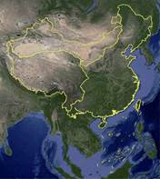
Figure 1 Map of four geo-ecosystem regions of China (.kmz data format)
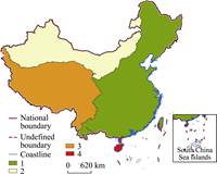
Figure 2 Map of four geo-ecosystem regions of China (.shp data format)
1. Eastern monsoon region 2. Northwest arid and semi-arid region, 3. Qinghai-Tibetan Plateau region 4. Southern tropic islands region
|
the administrative county boundaries map of China in 1∶4 million. Liu, C. finished the National Land Use Planning in 1994 together with the vector data based on the county boundary map in 1∶1 million[46]. Wang used the same method to develop the boundary data of the Loess Plateau[47–48]. The International Centre for Integrated Mountain Development (ICIMOD) did so for the outline of Hindu Kush Himalayans[49]. Liu proposed a new methodology for the geo-ecosystem regionalization supported by the earth observations in 2004[6], which could be a new tern of the geo-ecosystem regionalization from traditional scrimptions to a digital data. The successful examples were made, such as eco-regional boundary data of the roof of the world[50–51], Asia tropical humid & semi-humid eco-region[52–53], datasets of the boundary and area of the Tibetan Plateau[54–55], boundary data of East Asia summer monsoon geo-eco regions[56], Yalu river and basin data[57–58],boundary data of Hainan Island[59], boundary data of Taiwan Island[60], etc.
4.2.2 Summary of Metadata
The metadata summary of the dataset[61] was listed at the Table 3.
4.3 Results
Based on the four geo-ecosystem regions of China and the boundary Data (Albers projection,parallel latitudes are 25° and 47°, center longitude is 105°), following results were obtained. The biggest region of four geo-ecosystem regions of China is the Easter Monsoon Region; its area is 44.69% of total territorial area of China. It covers full of areas of Heilongjiang, Jilin, Liaoning, Henan, Shandong, Anhui, Jiangsu, Chongqing, Guizhou, Hubei, Hunan, Zejing, Shanghai, Jiangxi, Fujian, Beijing and Tianjin provinces (cities, Auto. regions), part of Inner Mongolia, Hebei, Shanxi, Shanxi, Ningxia, Gansu, Qinghai, Sichuan, Yunnan, Guganxi, Guangdong and Taiwan provinces (Auto. regions). The Qinghai-Tibetan Plateau region is the second large geo-ecosystem region of China, which covers about 30.02% of China, including full area of Tibet, most area of Qinghai province and part of Xinjiang, Gansu, Sichuan and Yunnan Provinces (Auto. regions). The Northwest arid and semi-arid region covers almost a quarter of territorial area of China (24.53%), including most areas of Xinjiang, Inner Mongolia and Ningxia autonomous regions and Gansu province, as well as parts of Shaanxi, Qinghai and Shanxi provinces. The southern tropic islands region covers the full area of Hainan province, parts of Guangdong, Guangxi, Yunan and Taiwan provinces (Auto. regions). Although it is only 0.76% of China, it is part of Asia tropical humid & semi-humid eco-region, which covers almost all area of Southeast Asia.
5 Conclusion
Four geo-ecosystem regions of China provide a new look at China’s geo-ecosystems in large. It could provide a new understanding how China’s geo-eco regions are linked with its surrounding environment.
Table 3 Metadata summary of GIS dataset of boundaries among four geo-eco regions of China
|
Items
|
Description
|
|
Title of dataset
|
GIS dataset of boundaries among four geo-eco regions of China
|
|
short name
|
ChinaGeoEcoRegions
|
|
Authors
|
Liu, C. L-3684-2016, Institute of Geographical Sciences and Natural Resources Research, Chinese Academy of Sciences (IGSNRR/CAS), lchuang@igsnrr.ac.cn
Shi, R. X. L-4389-2016, Institute of Geographical Sciences and Natural Resources Research, Chinese Academy of Sciences (IGSNRR/CAS), shirx@igsnrr.ac.cn
|
|
Geo-region
|
China, 3º50′2″N-53º33′31″N, 73º29′56″E-134º46′53″E
|
Year
|
2016
|
|
Spatial resolution
|
30 m
|
Number of data files
|
15 (2 in compressed)
|
|
Data formats
|
.shp, .kmz
|
Data size
|
52.91 MB (37.3 MB in compressed)
|
|
Data files and
contents
|
The dataset is consisted of 2 parts, inlcuding
1. ChinaGeoEcoRegionsshp.rar is the compressed dataset of the geo-ecosystem regionalization of China in .ship format, the compressed dataset size is 23.0 MB
2. ChinaGeoEcoRegions.kmz is the dataset of the geo-ecosystem regionalization of China in Google earth data format with the data size of 14.3 MB
|
|
Foundation Items
|
Chinese Academy of Sciences (INF0-115-C01-SDB3-02); Ministry of Science and Technology of P. R. China (2017YFA0604701)
|
|
Publisher
|
Global Change Research Data Publishing & Repository, http://www.geodoi.ac.cn
|
|
Address
|
No. 11A, Datun Road, Chaoyang District, Beijing 100101, China
|
|
Data sharing
policy
|
Data from the Global Change Research Data Publishing & Repository includes metadata, datasets (data products), and publications (in this case, in the Journal of Global Change Data & Discovery). Data sharing policy includes: (1) Data are openly available and can be free down-loaded via the Internet; (2) End users are encouraged to use Data subject to citation; (3) Users, who are by definition also value-added service providers, are welcome to redistribute Data subject to written permission from the GCdataPR Editorial Office and the issuance of a Data redistribution license; and (4) If Data are used to compile new datasets, the ‘ten percent principal’ should be followed such that Data records utilized should not surpass 10% of the new dataset contents, while sources should be clearly noted in suitable places in the new dataset[62]
|
References
[1] Yang, Q. Y., Zheng, D., Wu, S. H. Study on eco-regional system in China [J]. Progress in Natural Science, 2002, 12(3): 287-291.
[2] Zheng, D., Ge, Q. S., Zhang, X. Q., et al. Regionalization in China: retrospect and prospect [J]. Geographical Research. 2005, 24(3): 330-344.
[3] Lin, C. Outline of physical geographic regionalization in China (Abstract) [J]. Acta Geographica Sinica, 1954, 20(4): 395-418.
[4] Luo, K. F. Draft of division of physical geography in China [J]. Acta Geographica Sinica, 1954, 20(4): 379-394.
[5] Huang, B. W. Draft of China’s comprehensive physiographic regionalization [J]. Chinese Science Bulletin 1959, 18: 594-602.
[6] Liu, C. A new methodology for comprehensive physical regionalization of China supported by EOS in the moderate scale [J]. Progress in Geography, 2004, 23(6): 1-9.
[7] Ren, M. E., Yang, R. Z. Physical regionalization in China [J]. Acta Geographica Sinica, 1961, 27(1): 66-74.
[8] Ren, M. E., Yang, R. Z. Re-discussion on physical regionalization in China – Some theoretical problems of physical regionalization in China from the perspective of contradiction theory [J]. Journal of Nanjing University (Geography), 1963, (2): 1-12.
[9] Hou, X. Y., Jiang, X., Chen, C. D. Opinions on the development of agriculture, forestry, animal Husbandry, side-line and fisheries in China's physical regions [J]. Chinese Science Bulletin, 1963, (9): 8-26.
[10] Zhao, S. Q. A new scheme for comprehensive physical regionalization in China [J]. Acta Geographica Sinica, 1983, 38(1): 1-10.
[11] Workgroup of Summary of physical regionalization in China, National Committee for Agricultural Regionalization. Summary of physical regionalization in China [M]. Beijing: Science Press, 1984: 67-165.
[12] Hou, X. Y. Physical Eco-regionalization and Agricultural Development Strategy in China [M]. Beijing: Science Press, 1988: 30-81.
[13] Ni, S. X. A recent exploration of China’s comprehensive physiographic regionalization [J]. Journal of Nanjing University (Natural Sciences edition), 1994, 30(4): 706-714.
[14] Yang, Q. Y., Li, S. C. Some themes on eco-regionalization of China [J]. Acta Ecologica Sinica, 1999, 19(5): 596-601.
[15] Zheng, D. Study on eco-geography regional system in China [M]. Beijing: The Commercial Press, 2008.
[16] Liu, G. H., Fu, B. J. The principle and characteristics of ecological regionalization [J]. Advances in Environmental Science, 1998, 6(6): 69-72.
[17] Fu, B. J., Chen, L. D., Liu, G. H. The objectives, tasks and characteristics of China ecological regionalization [J]. Acta Ecologica Sinica, 1999, 19(5): 591-595.
[18] Fu, B. J., Liu, G. H., Chen, L. D. Scheme of ecological regionalization in China [J]. Acta Ecologica Sinica, 2001, 21(1): 1-6.
[19] Huang, X. W., Chen, B. M. The theory and application about the regionalization of Chinese ecological assets [J]. Acta Ecologica Sinica, 1999, 19(5): 602-606.
[20] Ouyang, Z. Y., Wang, X. K., Miao, H. China’s eco-environmental sensitivity and its spatial heterogeneity [J]. Acta Ecologica Sinica, 2000, 20(1): 9-12.
[21] Miao, H., Wang, X. K., Ouyang, Z. Y. Study on regionalization of eco-environmental stress process in China [J]. Acta Ecologica Sinica, 2001, 21(1): 7-13.
[22] Xu, J. T. Chen, B. M., Zhang, X. Q. Ecosystem productivity regionalization of China [J]. Acta Geographica Sinica, 2001, 56(4): 401-408.
[23] Ni, J., Chen, Z. X., Dong, M., et al. An eco-geographical regionalization for biodiversity in China [J]. Acta Botanica Sinica, 1998, 40(4): 370-382.
[24] Xie, Y., Li, D. M., MacKinnon, J. Preliminary researches on bio-geographical divisions of China [J]. Acta Ecologica Sinica, 2002, 22(10): 1599-1615.
[25] Wang, P., Shi, P. J. Comprehensive regionalization of agricultural natural disaster in China [J]. Journal of Natural Disasters, 2000, 9(4): 16-23.
[26] Fan, J. Draft of major function oriented zoning of China [J]. Acta Geographica Sinica, 2015, 70(2): 186-201.
[27] Wu, S. H., Pan, T., Liu, Y. H., et al. Comprehensive climate change risk regionalization of China [J]. Acta Geographica Sinica, 2017, 72(1): 3-17.
[28] Fang, C. L., Liu, H. M., Luo, K., et al. Process and proposal for comprehensive regionalization of Chinese human geography [J]. Journal of Geographical Sciences, 2017, 27(10): 1155-1168.
[29] Hu, H. Y. The distribution of population in China, with statistics and maps. Acta Geographica Sinica, 1935, 2(2): 33-74.
[30] Ni, S. X. Recent study of Soviet geographical sciences on physical geographical regionalization [J]. Geographical Research, 1982, 1(1): 95-102.
[31] Bailey, R. G., Hogg, H. C. A world ecoregions map for resource reporting [J]. Environmental Conservation, 1986(13): 195-202.
[32] Schultz, J. The Ecozones of the World: the Ecological Divisions of the Geosphere [M]. Berlin: Springer_Verlag, 1995.
[33] FAO. Global Ecological Zoning for the Global Forest Resources Assessment 2000 [R]. Final Report, Rome. FAO-Forest Resources Assessment Programme, Working Paper 56, 2001.
[34] Pielou, E. C. Biogeography [M]. New York: John Wiley and Sons, 1979.
[35] Udvardy, M. D. F. A Classification of the Biogeographical Provinces of the World [M]. Morges: IUCN, 1975.
[36] Olson, D. M., Dinerstein, E., Wikramanayake, E. D., et al. Terrestrial ecoregions of the world: a new map of life on earth [J]. BioScience, 2001, 51(11): 933-938.
[37] Köppen climate classification [OL]. https://en.wikipedia.org/wiki/K%C3%B6ppen_climate_classification.
[38] Tang, Y. L. Study on the tropical boundary in southwestern Guangxi from the viewpoint of national comprehensive physical regionalization [J]. Acta Geographica Sinica, 1959, 25(6): 460-462.
[39] Yu, X. F. Study on the tropical boundary in China [J]. Tropical Geography, 1981, 4: 8-14.
[40] Central Weather Bureau. Climate Regionalization in China (1∶36000000) [M]. In, Liu, G. M (ed). Atlas of Physical Geography in China. Beijing: SinoMaps Press, 2000: 49.
[41] Zeng, Z. X. Discussion on the tropical boundary of China from the distribution of cultivated plants [J]. Acta Phytoecologica ET Geobotanica Sinica, 1966, 4(1): 151-154.
[42] Ma, Q. X., Wang, F. G., Chen, B. H., et al. The demarcation between tropics and subtropics in Guangdong judging from the distribution of Antiaris toxicaria. [J]. Journal of Tropical and Subtropical Botany, 2004, 12(1): 7-12.
[43] Xu, X. H. Discussion on the division between tropical and subtropical zones in south China [J]. Acta Phytoecologica ET Geobotanica Sinica, 1982, 6(1): 74-77.
[44] Xu, X. H. Discussion on the boundary between tropical and subtropical zones in south China from the perspective of geobotany [J]. Acta Phytoecologica ET Geobotanica Sinica, 1964, 2(1): 137-139.
[45] China Agricultural Resources Planning Office, Institute of Agricultural Resources and Regional Planning, Chinese Academy of Agricultural Sciences. Agricultural Resources and Regional Planning in China [M]. Beijing: China Agricultural Science and Technology Publishing House, 1997.
[46] Liu, C., Zhou, Q., Wang, C., et al. Research on Zoning Scheme of overall Plan for Land Use in China [M]. In, Department of Land Use Planning, State Land Administration (eds). Research on overall plan for land use in China. Beijing: Science Press, 1994: 171-222.
[47] Wang, Z. X. Boundary data of Loess Plateau region [DB/OL]. Global Change Research Data Publishing & Repository, 2015. DOI: 10.3974/geodb.2015.01.09.V1.
[48] Wang, Z. X. Boundary Data of Loess Plateau Region [J]. Journal of Global Change Data & Discovery, 2017, 1(1): 113. DOI: 10.3974/geodp.2017.01.17.
[49] Outline of Hindu Kush Himalayans, ICIMOD. 2014. http://geoportal.icimod.org/Downloads/Download. aspx ?ID=3#.
[50] Liu, C., Shi, R. X., Chen, W. B. Eco-regional boundary data of the roof of the world [J]. Acta Geographica Sinica, 2014, 69(suppl.): 12-19, 104-112.
[51] Liu, C., Shi, R. X., Chen, W. B. Eco-regional boundary data of the roof of the world [DB/OL]. Global Change Research Data Publishing & Repository, 2014. DOI: 10.3974/geodb.2014.01.01.V1.
[52] Liu, C., Shi, R. X. Boundary data of Asia tropical humid & semi-humid eco-region [DB/OL]. Global Change Research Data Publishing & Repository, 2014. DOI: 10.3974/geodb.2014.02.04.V1.
[53] Liu, C., Shi, R. X. Boundary data for Asia tropical humid & semi-humid eco-region [J]. Journal of Global Change Data & Discovery, 2017, 1(3): 324-330. DOI: 10.3974/geodb.2017.03.11.
[54] Zhang, Y. L., Li, B. Y., Zheng, D. Datasets of the boundary and area of the Tibetan Plateau [DB/OL]. Global Change Research Data Publishing & Repository, 2014. DOI: 10.3974/geodb.2014.01.12.V1.
[55] Zhang, Y. L., Li, B. Y., Zheng, D. Datasets of the boundary and area of the Tibetan Plateau [J]. Acta Geographica Sinica, 2014, 69 (Suppl.): 65-68.
[56] Liu, C., Shi, R. X. Boundary data of East Asia summer monsoon geo_eco_region [DB/OL]. Global Change Research Data Publishing & Repository, 2015. DOI: 10.3974/geodb.2015.01.12.V1.
[57] Liu, C., Shi, R. X., Hao, M. M. Yalu River and basin [DB/OL]. Global Change Research Data Publishing & Repository, 2017. DOI: 10.3974/geodb.2017.04.19.V1.
[58] Liu, C., Shi, R. X., Hao, M. M. Yalu River and basin [J]. Journal of Global Change Data & Discovery, 2017, 1(4): 481-482. DOI: 10.3974/geodp.2017.04.17.
[59] Shen, Y. C., Liu, C., Shi, R. X. Boundary of Hainan Island [DB/OL]. Global Change Research Data Publishing & Repository, 2015. DOI: 10.3974/geodb.2015.01.10.V1.
[60] Liu, C., Shi, R. X. Boundary of Taiwan Island [DB/OL]. Global Change Research Data Publishing & Repository, 2015. DOI: 10.3974/geodb.2015.01.13.V1.
[61] Liu, C., Shi, R. X. GIS Dataset of boundaries among four geo-eco regions of China [DB/OL]. Global Change Research Data Publishing & Repository, 2016. DOI: 10.3974/geodb.2016.04.21.V1.
[62] GCdataPR Editorial Office. GCdataPR Data Sharing Policy [OL]. DOI: 10.3974/dp.policy.2014.05 (Updated 2017).