Erosion-Deposition Dataset of the Taoer River
Basin in Northeast China
Zhou, H.1 Chen, S. B.1* Xiang, T. T.2 Yu, Y. F.1 Cheng, X.1
1. College of GeoExploration Science and Technology, Jilin University, Changchun 130026, China;
2. Changchun School of Architecture, Changchun 130607, China
Abstract: The Erosion-Deposition Basic Dataset of the Taoer River Region in Northeast China (Ero-DepoData_TaoerRiver_NE_China) can be used for the quantitative extraction of the northeast plain boundary. We obtained the erosion-deposition balance points of the Taoer River region by establishing climate, slope, soil, and management databases using the Water Erosion Prediction Project model. The balance points that we obtained were compared with the boundary that was qualitatively extracted using elevation and slope data, and confirmed that the balance position can be matched with the boundary. The results indicated that the data were reliable.
Keywords: the Northeast Plain; Taoer River region; WEPP model; erosion-deposition process
1 Introduction
The Taoer River (120°E-124°E, 45°N-47°N) is the largest tributary of the Nenjiang River and is located in the transition region of the Greater Khingan Mountains and the Northeast Plain, which covers an area of 37,117 km2[1]. An analysis of the erosion-deposition process of the Taoer River could enable the quantitative extraction of the northeast plain boundary. The Greater Khingan Mountains are part of the boundary of China’s second and third terrain terraces, and this process could therefore also enable the extraction of this boundary. In this study, the Water Erosion Prediction Project (WEPP) model was used to study the erosion-deposition process of the Taoer River, and the Erosion-Deposition Basic Dataset of the Taoer River Basin in Northeast China (Ero-DepoData_TaoerRiver_NE_China for short) database was developed[2].
2 Metadata of Dataset
The summary of the metadata of Ero-DepoData_TaoerRiver_NE_China dataset is listed at Table 1. The content includes information of the authors, geographical region, spatial and temporal resolutions of data, dataset tiles, data format and size, data files, the foundation items, data publisher and access platform, as well as the data sharing policy.
Table 1 Metadata summary of the Ero-DepoData_TaoerRiver_NE_China dataset
|
Items
|
Description
|
|
Dataset full name
|
Erosion-deposition basic dataset of the Taoer River Basin in Northeast China
|
|
Dataset short name
|
Ero-DepoData_TaoerRiver_NE_China
|
|
Authors
|
Zhou, H. L-4968-2016, College of Geo-exploration Science and Technology, Jilin University, China, bb625218858@163.com
Chen, S. B. L-5789-2016, College of Geo-exploration Science and Technology, Jilin University, China, chensb@jlu.edu.cn
Xiang, T. T. L-5672-2016, Changchun School of Architecture, China, xiangtiantian1029@163.com
Yu, Y. F. L-5386-2016, College of Geo-exploration Science and Technology, Jilin University, China, yuyaf2011@163.com
Cheng, X. L-4911-2016, College of Geo-exploration Science and Technology, Jilin University, China, honeyxue0107@126.com
|
|
Geographical region
|
120°E-124°E, 45°N-47°N
|
|
Time
|
1982/1/1-2013/1/1; Temporal resolution: Daily; Spatial resolution: 30 m
|
|
Data Size
|
13.79 MB; Data format??rar, .kmz
|
|
|
|
Dataset and data files
|
The Ero-DepoData_TaoerRiver_NE_China consists of two files??
1. Ero-DepoData_TaoerRiver_NE_China.rar, this is the erosion-deposition raster and vector data. Data size is 11142.46 KB
2. TaoerRiver.kmz, this is the Taoer River boundary geographic information system data. Data size is 2976.30 KB
|
|
Foundation(s)
|
National Natural Science Foundation of China (78659, 12784); Chinese Academy of
Sciences (A75123)
|
|
Data Publisher
|
Global Change Research Data Publishing & Repository, http://www.geodoi.ac.cn/
|
|
Address
|
No.11A, Datun Road, Chaoyang District, Beijing 100101, China
|
|
Data sharing policy
|
Data from the Global Change Research Data Publishing & Repository includes metadata, datasets (data products), and publications (in this case, in the Journal of Global Change Data & Discovery). Data sharing policy includes: (1) Data are openly available and can be free downloaded via the Internet; (2) End users are encouraged to use Data subject to citation; (3) Users, who are by definition also value-added service providers, are welcome to redistribute Data subject to written permission from the GCdataPR Editorial Office and the issuance of a Data redistribution license; and (4) If Data are used to compile new datasets, the ‘ten per cent principal’ should be followed such that Data records utilized should not surpass 10% of the new dataset contents, while sources should be clearly noted in suitable places in the new dataset[3]
|
3 Methods
|
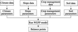
Figure 1 Research process used in the construction of the Ero-DepoData_TaoerRiver_NE_China database
|
The Ero-DepoData_TaoerRiver_NE_China was developed using the WEPP model. The WEPP model developed a physical description of rill erosion, interrill erosion, and the
sediment motion mechanism, which can predict soil erosion, sediment yield, and sediment discharge in different areas. It is a scientific research project developed by the United States Department of Agriculture, Agricultural Research Service, Soil Conservation Service, Forest Service, Interior Ministry of Land Management, and other partners[4,5]. The WEPP model is a process model that has generated four databases: climate, slope, soil, and crop management. Using the four databases, soil erosion, sediment yield, and sediment discharge can be predicted. A schematic showing the research process involved is given in Figure 1.
In the research process, climate data downloaded from the China Meteorological Data Sharing Service System[6] was used to model the meteorological system in the Taoer River region with the WEPP model. Digital elevation model data were divided into several single slopes by ArcGIS (Figure 2). After calculating the mean slope and slope length using ArcGIS, the slope database was established using the WEPP model. A crop management database was established using GlobCover2009 data, which can extract different types of ecological regions, with a hierarchical classification. The Land Cover Classification System was applied to divide the global surface into 22 land cover types[7]. Then, the land types were obtained. The soil database was established using six soil parameters[8].
|

Figure 2 Map of slope unit data of Taoer River Basin From the four databases, the erosion-deposition balance points could be determined using the WEPP model.
|
4 Dataset Compositions, Quality Control, and Validation
4.1 Dataset Composition
The Ero-DepoData_TaoerRiver_NE_China.rar dataset contains raster and vector data. The data size is 11142.46 KB. The raster data include MeanSlope.img and MeanLength.img. The slope data are calculated using Zonnal Statistics in ArcGIS (Figure 3). The mean slope length data are calculated using Raster Calculator and Zonnal Statistics[9] (Figure 4).
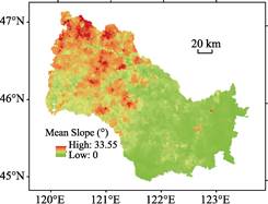
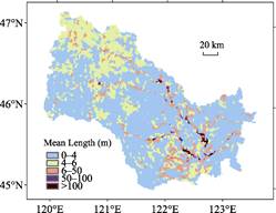
Figure 3 Slope classification data of Taoer River Basin Figure 4 Slope length classification data of Taoer River Basin
The vector data include TaoerRiver.shp and Balance_Point.shp. TaoerRiver.shp includes the slope length (Length), slope (°), the amount of erosion at 13 balance points (Soil_Loss), and the amount deposited (Deposition). The Balance_Point.shp is the location of the balance point that has the same amount of erosion and deposition.
TaoerRiver.kmz is the Taoer River boundary geographic information system data formed by Google Earth. The data size is 2,976.30 KB.
4.2 Quality Control and Validation
The method used to divide China’s terrain into distinct regions involved the classification of elevation and slope in northeast China to define the boundary between the Greater Khingan Mountains and the Northeast Plain. The balance points we obtained compared with the boundary qualitatively extracted by the elevation and slope showed that the use of the balance position can determine the boundary (Figures 5 and 6). The results indicate that the data are reliable.
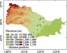

Figure 5 Balance position and elevation Figure 6 Balance position and slope classification
5 Discussion and Conclusion
This dataset was produced using the ASTER Global Digital Elevation Model (ASTER GDEM) and WEPP model. Comparing the results with other methods, the data are considered reliable, and have produced a reference value for the quantitative classification of the Northeast Plain.
Author Contributions
Xiang, T. T. designed the study. Zhou, H. wrote the paper. Zhou, H., Chen, S. B., Xiang, T. T., Yu, Y. F., and Cheng, X. contributed to the data processing and analysis. Zhou, H. undertook the data validation.
References
[1] Xia. B. C., Hu, J. M., Song, X. S. analysis of land-use change in taoerhe catchment during last 15 years [J]. Journal of Soil and Water Conservation, 2004, 8(2): 122-125.
[2] Zhou, H., Chen, S. B., Xiang, T. T., et al. 2015. Erosion-deposition dataset in facets of Taoer River Watershed in northeast China [DB/OL]. Global Change Research Data Publishing & Repository, 2015. DOI: 10.3974/geodb.2015.01.05.V1.
[3] GCdataPR Editorial Office. GCdataPR data sharing policy [OL]. DOI: 10.3974/dp.policy.2014.05 (Updated 2017).
[4] Zhang, Y. B., Zheng, F. L, Jia, Y. Y. WEPP model and its application [J]. Research of Soil and Water Conservation, 2004, 11(4): 146-149.
[5] Xiao, P. Q., Yao, W. Y. Erosion theoretical basis of WEPP model [J]. Yellow River, 2005, 27(6): 38-50.
[6] China Meteorological Data Sharing Service System [OL]. http://cdc.cma.gov.cn/home.do.
[7] Xiang, T. T. Studying on process of erosion-deposition on eastern slope of Great Khingan and its indicative significance [D]. Changchun: Jilin University, 2014.
[8] Ma, L., Zuo, C. Q. Major factors affecting erosion and runoff on red soil slope based on WEPP model [J]. Bulletin of Soil and Water Conservation, 2012, 32(6): 26-33.
[9] Kong, Y. P., Zhang, K. L., Cao, L. Appraise slope length factors in soil erosion study [J]. Research of Soil and Water Conservation, 2008, 15(4): 43-47.