Global Change Data Encyclopedia
Hokkaido Island, Japan
Chen, W. B.1,2 Doko, T.1,2 Shi, R. X.3 Liu, C.3
1. Keio Research Institute at SFC, Keio University, Fujisawa
2520882, Japan;
2. Nature & Science Consulting Co. Ltd., Yokohama
2310032, Japan;
3. Institute of Geographic Sciences and Natural Resources
Research, Chinese Academy of Sciences, Beijing 100101, China
Keywords: Hokkaido
Island; Japan; data encyclopedia
|
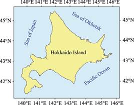
Figure 1 Map of Hokkaido Island (.shp format)
(.shp format)
|
Hokkaido
Island is located at northern Japan, east of Asia continent. It is the island
among Sea of Okhotsk, Sea of Japan and the Pacific Ocean. It is 42 km separated
from Sakhalin Island by the Zonggu Strait (also known the Soya Strait) in the
north, and 19 km from the Honshu Island by Tsugaru Strait in the south, and separated
from Kuril Islands in the northeast. It is administrated by the Hokkaido county
of Japan. The geolocation of Hokkaido Island is between 41??23??51??N and
45??31??23??N, 139??45??55??E and 145??49??02??E[1] (Figure 1, 2).
Hokkaido Island is approximately diamond-shaped
with a length of 413 km from north to south and 508 km from east to west. It is
the second largest island in Japan with an area of 77,635.37 km² and a
coastline of 3,753.26 km. Hokkaido has a temperate maritime climate. The
average temperature in January is −4?C −10 ??C, the average temperature in August
is 18?C20 ??C, and the annual precipitation is 800?C1,200 mm[2].
Snow covers from December to next March. Mount Asahi Volcano on the island,
2,290 m above sea level[3]. Due
to its special location at the seismic belt of Pacific Rim, earthquakes are
frequent in the Hokkaido Island. Besides numerous earthquakes, the volcanoes
are still considered active too.
|
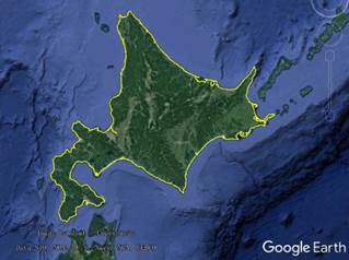
Figure 2 Map of Hokkaido Island (.kmz format)
|
Hokkaido Island is administratively
under the jurisdiction of Hokkaido, Japan. Hokkaido has a low population
density and beautiful natural scenery, and is a famous tourist destination in
Japan. Major island cities include Sapporo, Hakodate, Asahikawa and Otaru. The
main ports are Tomakomai Port, Muroran Port, and Kushiro Port. Major airports
are New Chitose Airport, Hakodate Airport, Kushiro Airport, and Asahikawa Airport[4].
Hokkaido island dataset
is part of global multiple scale shorelines dataset[5]. The dataset of Hokkaido Island was developed based on the
Google Earth satellite images in 2015 and related maps. The dataset is archived
in .kmz and .shp[6] formats,
consists of 17 data files with data size of 6.53 MB (compressed to two data
files with 4.36 MB).
References
[1]
Chen, W. B., Doko, T., Shi, R.
X., et al. Hokkaido Island [DB/OL]. Global
Change Research Data Publishing & Repository, 2019. DOI:
10.3974/geodb.2019.06.19.V1.
[2]
Hokkaido [OL]. https://baike.so.com/doc/822099-869493.html.
[3]
Ma, J. X. World Atlas:
Topographic Edition [M]. Beijing: China Map Publishing House, 2013.
[4]
Outline of Hokkaido Region
(Japan Pass) [OL]. Https://www.517japan.com/viewnews-585.html.
[5]
Liu, C., Shi, R. X., Zhang, Y.
H. et al. Global multiple scale shorelines
dataset based on Google Earth images (2015) [DB/OL]. Global Change Research
Data Publishing & Repository, 2019. DOI: 10.3974/geodb.2019.04.13.V1.
Data
Computing Environment
[6]
ESRI. ArcGIS campus license of
Institute of Geographic Sciences and Natural Resources Research, Chinese
Academy of Sciences.
URL for
Data Downloading
http://www.geodoi.ac.cn/WebEn/doi.aspx?Id=1369.
Or search through: http://www.geodoi.ac.cn.