Dataset of Strategic Transformation Regionalization for the Agricultural Comprehensive Development of Ningxia, China
Shi, W. J.1,2* Wang, M. L.1,2
1. Key Laboratory of Land Surface Pattern and Simulation, Institute of Geographic Sciences and Natural Resources Research, CAS, Beijing 100101, China;
2. College of Resources and Environment, University of Chinese Academy of Sciences, Beijing 100049, China
Abstract: Based on the single target and type of existing agricultural divisions, this dataset taking Ningxia as research region, integrates the spatial data of cultivated land, climate, water resources, topography, landform, project layout and ecological planning related to agriculture, and devises 13 indices using the geographic comprehensive regionalization method. The indices considered a combination of dynamic and static, qualitative and quantitative, and agricultural and ecological factors. Seven first-level zonings and 24 secondary zones (sub-categories) had been identified. The dataset was archived in .shp and .kmz data format with a data size of 1.23 MB (0.98 MB in the compressed file). Related analysis results were published in the Journal of Geographical Sciences in 2016 (Vol. 26, No. 12)
Keywords: Ningxia; agricultural comprehensive development; regionalization; indices; Journal of Geographical Sciences
1 Introduction
Since 1988, China has begun to implement agricultural comprehensive development (ACD). This measure has made positive contributions to strengthening agricultural infrastructure construction, ensuring national food security and promoting farmers’ continued income growth. However, the previous ACD layout covered most of the agricultural counties in the country, which has caused some phenomena that do not match the current resources and environment in China in the subsequent development process. For example, the water resource carrying capacity is not effectively considered, the regional soil conditions are not fully considered, and the comprehensive ecological management is insufficient. With the development of China’s economy and society, new forms and new challenges in the process of ACD have formed.
Since the founding of New China, the country has carried out three large-scale national agricultural zoning works[1]. To solve the problem of agricultural district development and rational allocation and to accelerate the development of agricultural production, the Ministry of Agriculture and Rural Affairs of P. R. China began to require agricultural zoning in various provinces in 1953[2–3]. In the following decades, the comprehensive agricultural zoning was initially completed, and the research on the more detailed types of agricultural regions was further deepened[4]. In the 1990s, the theoretical system of comprehensive agricultural zoning in China was gradually formed[5]; after entering the 21st century, research on agricultural suitability zoning based on natural agricultural conditions and quantitative models and methods also gradually developed[6–13].
2 Metadata of Dataset
The metadata of the “Dataset of strategical transformation regionalization for the agricultural comprehensive development in Ningxia Hui autonomous region of China”[14] is summarized in Table 1.
3 Methods
3.1 Algorithm Principle
The indices were considered in combinations of dynamic and static, qualitative and quantitative, and agricultural and ecological factors. These were based on the spatial characteristics of the different climate resources, cultivated land resources, water resources, topography, landforms and ecology of the irrigated area of North Ningxia, the central arid zone and the southern loess hilly region. There were seven of indices: cropland, water resources, climate, terrain, landform, ACD project, and ecological planning. GIS spatial analysis method was used to divide the different functional areas into township (town)-based units.
Table 1 Metadata summary of the “Dataset of strategical transformation regionalization for the agricultural comprehensive development in Ningxia Hui Autonomous Region of China”
|
Items
|
Description
|
|
Dataset full name
|
Dataset of strategical transformation regionalization for the agricultural comprehensive development of Ningxia Hui Autonomous Region in China
|
|
Dataset short name
|
AgriCDRegionalizationNX
|
|
Authors
|
Shi, W. J. S-3255-2018, Institute of Geographic Sciences and Natural Resources Research, Chinese Academy of Sciences, shiwj@lreis.ac.cn
|
|
|
Cui, J. Y., Institute of Geographic Sciences and Natural Resources Research, Chinese Academy of Sciences, cuijiaying115@163.com
|
|
Geographical region
|
Ningxia Hui autonomous region in China
|
|
Data format
|
.dbf, .prj, .sbn, .shp, .shx, .xml, .kml
|
|
|
|
Data size
|
1.23 MB (0.98 MB after compression)
|
|
|
|
Data files
|
The dataset consists of eight files, stored in .shp and .kmz formats
|
|
Foundations
|
National Natural Science Foundation of China (41371002, 41301355, 41401113); Chinese Academy of Science (XDA05090310, KFJ-EW-STS-019-01)
|
|
Data publisher
|
Global Change Research Data Publishing & Repository, http://www.geodoi.ac.cn
|
|
Address
|
No. 11A, Datun Road, Chaoyang District, Beijing 100101, China
|
|
Data sharing policy
|
Data from the Global Change Research Data Publishing & Repository includes metadata, datasets (data products), and publications (in this case, in the Journal of Global Change Data & Discovery). Data sharing policy includes: (1) Data are openly available and can be freely downloaded via the Internet; (2) End users are encouraged to use Data subject to citation; (3) Users, who are by definition also value-added service providers, are welcome to redistribute Data subject to written permission from the GCdataPR Editorial Office and the issuance of a Data redistribution license; and (4) If Data are used to compile new datasets, the ‘ten percent principal’ should be followed such that Data records utilized should not surpass 10% of the new dataset contents, while sources should be clearly noted in suitable places in the new dataset[15]
|
In the dataset, we selected the percentage of areas of cropland, basic farmland, and high-yielding fields in each town to represent the proportion of cropland or high-quality cropland. For water resources, the percentage of areas with a recharge modulus greater than 200,000 m3/(a·km2) or lower than 10,000 m3/(a·km2) were used to represent the volume of water resources used for agricultural irrigation. For climate, we chose the percentage area with precipitation lower than 200 mm to represent the amount of precipitation. For terrain, we selected the percentage of areas above 15° or 25° slope to represent the limiting factor of the terrain. For geomorphology, the percentage of areas of mountains, hills, and plains were selected to analyze the suitability of ACD. For the distribution of ACD projects, the percentage of areas of high-standard farmland projects and the planning projects to 2020 represent the development levels of the past and future. For ecological planning, the percentage area devoted to agriculture-related functions was selected as being representative of agricultural importance.
3.2 Technical Route
According to the framework of strategic transformation of regionalization of Ningxia, the specific research and development process of this dataset is shown in Figure 1. (I) Collect data through surveys and visits, and establish a single factor indicator dataset. (II) The suitability levels of these indices for agricultural production were evaluated according to the spatial distribution of cropland, high standard farmland, high-yield fields, ACD projected areas, the plan of high-standard farmland in Ningxia for 2020, etc. (III) The necessary conditions for prioritized, protected, and restricted regions were determined by the evaluation of each index. (IV) According to the suitability levels of the different indices from III, the limiting indices and the levels for the agricultural development in Ningxia were identified. (V) Indicator thresholds for suitable agricultural development and agricultural development in key development regions, conservation development regions and restricted development regions were identified. (VI) A percentage area of each index of the suitable and limiting thresholds was calculated at a town scale. (VII) The criteria of the three regions were defined according to the spatial distribution of each index threshold in each town, and the regionalization types were classified according to the criteria.
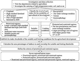
Figure 1 Technical route for the strategic transformation of regionalization for Ningxia
agricultural comprehensive development
4 Results and Validation
4.1 Dataset Composition
The strategic transformation dataset of regionalization for the ACD of Ningxia in China consisted of eight files, stored as .dbf, .prj, .sbn, .sbx, .shp, .shx, .xml and .kml formats. The data size was 1.23 MB (0.98 MB after compression).
4.2 Data Results
We used Ningxia as an example to study the principles and methods of strategic transformation of regionalization for ACD. Based on the natural conditions of cultivated land, water, topography, landforms and ecology in the region, the geography comprehensive zoning method was adopted to formulate the agriculture in Ningxia. The Ningxia region was divided into three major regions (key development regions, protected development regions and restrictive development regions), and there were seven major types and 24 sub-categories (Table 2). Roman numerals were used in the type names: “I prioritized regions”, etc.
|

Figure 2 Spatial distribution of regionalization types for strategic transformation of Ningxia agricultural comprehensive development
|
The names of the subtypes reflect not only the seven major types of regionalization but also the ecological location of the division unit, such as “VI1 the restricted and protected regions with sand prevention and control” and “VII2 the restricted regions with sand prevention and control”. In addition, if the region had an obvious regional feature, we named the region according to the sequential geographic location, ecological zone, and development type; for example, “II2 the prioritized and restricted regions irrigated with water-saving reform in the Weining Plain”, “VII3 The restricted regions with forest and grass on Helan Mountain”, and so on.
In the first-level type of zoning, Ningxia was divided into key development zones (including 44 towns), “prioritized and restricted” regions (3 towns), protected regions (23 towns), “protected and restricted” regions (5 towns), “restricted and prioritized” regions (17 towns), “restricted and protected” regions (83 towns) and restricted regions (20 towns) (Figure 2).
Based on the primary division, Ningxia was further divided into 24 secondary types (Figure 3). Prioritized regions or “prioritized and restricted” regions were mainly distributed in the Yellow River Irrigation District in the north of Ningxia; protected regions or “protected and restricted” regions were mainly distributed in the Yellow River irrigated farmland in the plains of the Qingshui River in the southern loess hilly region. The ecological zone included the Hulu River tributary valley irrigated farmland area, the soil and water loss control functional zone of the Liangzhu hills on both sides of the Hulugou and other forest and grass protection or soil erosion areas, and the arid zone in central Ningxia. The restricted regions, “restricted and prioritized regions” and “restricted and protected” regions were mainly distributed in the northern part of Ningxia, the northern part of the Helan Mountain, the shrub grassland protection ecological function zone, the Helan Mountain forest nature protection ecological function zone, the eastern Helan Mountains floodplain forest and grass construction zone, the mountain torrent prevention and control of ecological functional areas, the grassland-desert vegetation restoration ecological function area of Taole terrace, the Yinchuan urban and wetland protection ecological function area, the Weining Beishan desert and semi-desert vegetation restoration ecological function area, the central arid zone and most of the southern hilly areas where outside the district's non-prioritized regions and protected regions.
5 Discussion and Conclusion
|
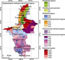
Figure 3 Spatial distribution of the regionalization subtypes of the strategy transformation for Ningxia agricultural comprehensive development
|
The strategic transformation of the ACD strategy is the basis for constructing the regional development pattern of ACD with “sustaining sustainability and enhancing competitiveness”. After the founding of the People’s Republic of China, China has carried out large-scale national agricultural zoning work[1]. With the deeper systematic research on the types of agricultural regions, the theoretical system of China’s agricultural zoning was gradually formed in the 1990s[5], and models and methods for the study of agricultural suitability zoning have been gradually established[6–13]. In addition, since the 1950s, China has experienced comprehensive
Table 2 Scheme of the strategy transformation regionalization for Ningxia ACD[16]
|
Types
|
Subtypes
|
|
I. Prioritized
regions
|
I1 The prioritized regions with paddy-dryland rotations in south Yinchuan
|
|
I2 The prioritized regions with dryland in north Yinchuan and farmland with pumping irrigation in Taole
|
|
I3 The prioritized regions irrigated with water-saving reform in the Weining Plain
|
|
II. Prioritized and
restricted regions
|
II1 The prioritized regions with paddy-dryland rotations in south Yinchuan, and the restricted regions with sand prevention and control
|
|
II2 The prioritized and restricted regions irrigated with water-saving reform in the Weining Plain
|
|
III. Protected regions
|
III1 The protected regions with soil erosion and water-saving irrigation in the valley
|
|
III2 The protected regions with water-saving irrigation pumped from the Yellow River
|
|
IV. Protected and restricted regions
|
IV1 The protected regions with water-saving irrigation pumped from the Yellow River and the restricted regions with soil erosion
|
|
IV2 The protected regions with grass-crop rotations, and the restricted regions with forest
and grass
|
|
V. Restricted and prioritized regions
|
V1 The restricted regions with forest and grass on Helan Mountain, and the prioritized regions with irrigated dryland in north Yinchuan
|
|
V2 The restricted regions with forest and grass on Helan Mountain, and the prioritized regions with paddy-dryland rotations in south Yinchuan
|
|
V3 The restricted regions with desert and semi-desert, and the prioritized regions with irrigation water-saving transformation
|
|
V4 The restricted and the prioritized regions of desert steppe
|
|
VI. Restricted and protected regions
|
VI1 The restricted and protected regions with sand prevention and control
|
|
VI2 The restricted and protected regions with desert steppe
|
|
VI3 The restricted and protected regions with forest and grass
|
|
VI4 The restricted and protected regions with soil erosion
|
|
VI5 The restricted and protected regions with water conservation
|
|
VI6 The restricted and protected regions returning cropland to grassland
|
|
VII. Restricted regions
|
VII1 The restricted regions with urban construction
|
|
VII2 The restricted regions with sand prevention and control
|
|
VII3 The restricted regions with forest and grass on Helan Mountain
|
|
VII4 The restricted regions with desert steppe
|
|
VII5 The restricted regions being returned from cropland to grassland
|
natural geographical divisions[17–23], main functional divisions[24–27], soil and water conservation divisions[28], climate divisions[29], and land consolidation treatments[30] Valuable zoning results, such as ecosystem productivity zoning[31], ecological zoning[32], and geomorphic zoning[33], also play an important guiding role in the agricultural layout. Based on previous studies, this dataset scientifically analyzes Ningxia’s agricultural natural endowments and adopts the geography comprehensive zoning analysis method to obtain a ACD strategic transformation zoning plan for Ningxia.
This research is the first strategic transformation of regionalization for the ACD at the town scale in a province or an autonomous region, and it can be used in enquiries, analysis and decision-making.
The zoning results can provide an important basis for the overall layout of the ACD strategy transformation at the national level, provide a basis for the specific implementation of the ACD strategy transformation work of Ningxia, and promote the strategic transformation of ACD in other provinces or regions of the country.
The research on the strategic transformation of the ACD still needs to be improved. First, due to data limitations and Ningxia’s own environmental problems, environmental pollution indicators could not be considered in the establishment of the indicator system. However, as regional environmental pollution, especially soil pollution, continues to emerge, regional environmental pollution levels should also be included as indicators. Second, in the process of implementing comprehensive agricultural zoning, we should focus on the principles of local conditions, echelons, and policies, clarify the direction and focus of sustainable agricultural development, optimize the agricultural layout, and provide a scientific basis for achieving sustainable agricultural development.
Author Contributions
Shi, W. J. designed the algorithms of dataset, and contributed to the data processing and analysis. Wang, M. L. wrote the data paper.
References
[1] Tao, H. J., Chen, T. Z. Literature review on agricultural regionalization theory and practice research [J]. Chinese Journal of Agricultural Resources and Regional Planning, 2014, 35(2): 59–66.
[2] Agricultural Regionalization Research Team of Geographical Society of China. The New Delelopment of Agricultural Regionalization in China [J]. Acta Geographica Sinica, 1965, 31(4): 269–276.
[3] Zhou, Q. Y. 1957. Fundamental problems on the division of agricultural regions of China [J]. Acta Geographica Sinica, 1957, 23(2): 127–144.
[4] Deng, J. Z. Property, tasks and further problems of agricultural regionalization [J]. Chinese Journal of Agricultural Resources and Regional Planning, 1984, 1: 57–68.
[5] Zhou, L. S. Theory and Practice of Agricultural Regionalization in China [M]. Hefei: University of Science and Technology of China Press, 1993.
[6] Xu, H. D., Wei, X., Huang, W., et al. Agricultural regionalization based on soil environment quality: a case study of Zhejiang province [J]. Journal of Zhejiang University (Agriculture & Life Science), 2008, 34(4): 447–452.
[7] Jin, X., Hu, J. L. Studies on agricultural regionalization form the perspective of virtual water: a case of Huang-Huai-Hai Plain [J]. Chinese Journal of Agricultural Resources and Regional Planning, 2011, 32(2): 53–57.
[8] Chen, X. H., Wang, Y. J., Wan, L. H., et al. Study on the eco-agriculture regionalization based on hierarchical cluster analysis in Northeast China [J]. Economic Geography, 2012, 32(1): 137–140.
[9] Liu, Y. Y., Shi, D. M., Hu, Y. X., et al. Risk analysis and regionalization of agrometeorological drought hazard in Jilin Province of Northeast China [J]. Chinese Journal of Ecology, 2013, 32(6): 1518–1524.
[10] Wang, L. X., Meng, D., Geng, X. H., et al. GIS based drought risk assessment and zoning in Ningxia [J]. Journal of Natural Disasters, 2013, 22(5): 213–220.
[11] Liu, Y., Zhang, Y., Guo, L. Towards realistic assessment of cultivated land quality in an ecologically fragile environment: a satellite imagery-based approach [J]. Applied Geography, 2010, 30(2): 271–281.
[12] Miao, B. L., Hou, Q., Liang, C. Z. Agricultural climate regionalization of dryland farming for potato in Yinshan based on GIS [J]. Chinese Journal of Applied Ecology, 2015, 26(1): 278–282.
[13] Lv, X. F., Wang, Y. L., Zhang, Y. L., et al. Research on agricultural functions regionalization and sustainable development strategy of ecologically vulnerable environment in the west of China: a case of Yanchi county in Ningxia Hui autonomous region [J]. Journal of Natural Resources, 2007, 22(2): 177–184.
[14] Shi, W. J., Cui, J. Y. Dataset of strategical transformation regionalization for the agricultural comprehensive development in Ningxia Hui autonomous region of China [DB/OL]. Global Change Research Data Publishing & Repository, 2018. DOI: 10.3974/geodb.2018.08.02.V1.
[15] GCdataPR Editorial Office. GCdataPR data sharing policy [OL]. DOI: 10.3974/dp.policy.2014.05 (Updated 2017).
[16] Shi, W. J., Hu, Y. F., Shi, X. L., et al. Strategy transformation regionalization for the agricultural comprehensive development in Ningxia Hui autonomous region of China [J]. Acta Geographica Sinica, 2015, 70(12): 1884–1896. DOI: 10.11821/dlxb201512003.
[17] Shi, W. J., Hu, Y. F., Shi, X. L., et al. Strategic transformation of regionalization for the agricultural comprehensive development: the example of Ningxia Hui autonomous region in China [J]. Journal of Geographical Sciences, 2016, 26(12): 1675–1688. DOI: 10.1007/s11442-016-1352-6.
[18] Liu, Y. H., Zheng, D., Ge, Q. S., et al. Problems on the research of comprehensive regionalization in China [J]. Geographical Research, 2005, 24(3): 321–329.
[19] Huang, B. W. China comprehensive natural zoning draft [J]. Chinese Science Bulletin, 1959(18): 594–602.
[20] Hou, X. Y. Chinese Ecological Regionalization and the Development Strategy of Big Agriculture [M]. Beijing: Science Press, 1988.
[21] Ren, M. E., Yang, R. Z. Problems on the research of natural regionalization in China [J]. Acta Geographica Sinica, 1961, 27(1): 66–74.
[22] Zhao, S. Q. A new scheme for comprehensive physical regionalization [J]. Acta Geographica Sinica, 1983, 38(1): 1–10.
[23] Zheng, D., Ou, Y., Zhou, C. H. Understanding of and thinking over geographical regionalization methodology [J]. Acta Geographica Sinica, 2008, 63(6): 563–573.
[24] Wu, S. H., Liu, W. D. An integrated approach to classification of territorial system: a case study of Tibetan Plateau [J]. Geographical Research, 2005, 24(2): 169–177, 321.
[25] Fan, J. Draft of major function oriented zoning of China [J]. Acta Geographica Sinica, 2015, 70(2): 186–201.
[26] Gu, C. L., Zhang, X. M., Liu, J. Y., et al. The development spatial regionalization of Yancheng city and relevant consideration [J]. Acta Geographica Sinica, 2007, 62(8): 787–798.
[27] Wang, C. S., Zhao, H. Y., Sun, G. Y., et al. Function zoning of development optimized area at a county level: a case study of Shangyu, Zhejiang [J]. Geographical Research, 2010, 29(3): 481–490.
[28] Fan, J., Li, P. The scientific foundation of major function oriented zoning in China [J]. Journal of Geographical Sciences, 2009, 19(5): 515–531.
[29] Zhao, Y., Wang, Z. G., Sun, B. P., et al. A primary study on scheme of soil and water conservation regionalization in China [J]. Acta Geographica Sinica, 2013, 68(3): 307–317.
[30] Zheng, J. Y., Yin, Y. H., Li, B. Y. A new scheme for climate regionalization in China [J]. Acta Geographica Sinica, 2010, 65(1): 3–12.
[31] Feng, Z. M., Pan, M. Q., Zhang, J. Study on zoning of China’s integrated land consolidation [J]. Journal of Natural Resources, 2006, 21(1): 45–54.
[32] Xu, J. T., Chen, B. M., Zhang, X. Q. Ecosystem productivity regionalization of China [J]. Acta Geographica Sinica, 2001, 56(4): 401–408.
[33] Xie, G. D., Zhang, C. H., Zhang, L. B., et al. China’s country-scale ecological regionalization [J]. Journal of Natural Resources, 2012, 27(1): 154–162.
[34] Li, B. Y., Pan, B. T., Cheng, W. M., et al. Research on geomorphological regionalization of China [J]. Acta Geographica Sinica, 2013, 68(3): 291–306.