Spatial Dataset of Ancient Ginkgo Trees in Luoyang Town,
Suizhou, China (2023)
Huang, Y. H.1, 2 Wang, Z. B.1, 2* Wang, S. H.3 Xu, D. C.3, 4 Li, X.3, 4 Zhou, J. Y.3, 4
1. Institute of Geographic Sciences and Natural Resources
Research, Chinese Academy of Sciences, Beijing 100101, China;
2.
University of Chinese Academy of Sciences, Beijing 100049, China;
3.
Aerospace Information Research Institute, Chinese Academy of Sciences, Beijing
100094, China;
4.
Faculty of Geomatics, Lanzhou Jiaotong University, Lanzhou 730070, China
Abstract: Analyzing the spatial distribution of ancient ginkgo trees (Ginkgo biloba L.) in
Luoyang town, China,
contributes to a comprehensive understanding of the geographical patterns of
these important trees.
This study aims to
establishes a reliable foundation for rural revitalization projects and aids in the conservation and sustainable
utilization of natural cultural heritage. The dataset is constructed based on
the authors' investigations
of ancient ginkgo trees in Luoyang town, incorporating a diverse range of
heterogeneous data, such as elevation, topography, waterbodies, and roads. The resulting spatial distribution
dataset of ancient ginkgo trees in Luoyang town,
Suizhou, Hubei
reveals that Luoyang town boasts a relatively high number and density of these trees, totaling 2,036 trees with geotagged locations. The spatial arrangement of these trees is influenced
by factors such as topography, elevation, waterbodies, and roads, exhibiting a tendency to cluster in the southwestern
part of Luoyang town. The
dataset comprises information on (1) the distribution of ancient ginkgo trees,
with attributes including geographic location, height, diameter at breast
height (DBH), growth status, and ancient tree classification; (2) elevation
classification data; (3) distance from roads; (4) statistical analyses of tree distribution relationships with changes in elevation,
slope, and aspect; and (5)
field investigation photos. The data is archived in .shp, .xlsx, .jpg, and .txt formats, consisting of 41
data files with a total size of 88.9 MB (compressed into one file, 83.2 MB).
Keywords: ancient ginkgo trees; dataset;
spatial distribution; Luoyang town; natural cultural heritage
DOI: https://doi.org/10.3974/geodp.2023.04.09
CSTR: https://cstr.escience.org.cn/CSTR:20146.14.2023.04.09
Dataset Availability Statement:
The dataset
supporting this paper was published and is accessible through the Digital Journal of
Global Change Data Repository at: https://doi.org/10.3974/geodb.2024.01.03.V1
or https://cstr.escience.org.cn/CSTR:20146.11.2024.01.03.V1.
1 Introduction
Ginkgo
(Ginkgo biloba L.), a member of the
gymnosperm division and the Ginkgoaceae family, stands as the sole surviving
species within the Ginkgoales suborder of the ginkgo order. It holds
the distinction of being the oldest surviving gymnosperm plant following the
Quaternary glacial movement. Presently, wild ginkgo are
exclusively found in China[1].
Plant
systematists posit that numerous gymnosperms emerged during the Carboniferous
period; fossil evidence suggests the genesis of ginkgo-like plants in the Upper
Carboniferous period, their progression through the Permian to the Late
Triassic of the Mesozoic era, and significant prominence within plant groups by
the Mesozoic??s conclusion. However, the Late Cretaceous period ushered in
abrupt climate changes, marking the decline of gymnosperms. As the Tertiary Period concluded
and the Quaternary Period commenced, extensive glaciers formed in the Northern
Hemisphere, and ginkgo-like plants in North America, Europe, Oceania, and South
America faced extinction. Notably, China??s glaciers were less pervasive than
those in Europe, with the North China region experiencing relatively mild
erosional effects. Consequently, this ancient and rare plant endured in China[2]. Areas such as Tianmu Mountain in Zhejiang,
Shennongjia in Hubei, and the Dabie Mountains at the junction of Anhui, Hubei,
and Henan provinces experienced minimal glacier erosion, preserving wild or
semi-wild ginkgo trees to this day.
Suizhou, situated in the northern part of
Hubei province, stands out as the most conducive environment for ginkgo growth;
its optimal climate, soil quality, and vegetation conditions create an ideal
habitat for the natural growth and reproduction of ginkgo. The unique
topography of Suizhou, hindering the invasion of cold currents since the end of
the Tertiary Period, has made it one of the few areas with natural, wild ginkgo
globally[3]. Luoyang town in Suizhou hosts a
natural ancient ginkgo community??one of the densest, largest, and
best-preserved in the world, boasting exceptional natural and cultural value.
The establishment of the spatial distribution dataset of ginkgo trees in
Luoyang town contributes to the conservation of plant species, biodiversity exploration,
ecological balance, and understanding dynamic changes in plant communities in
the region. This dataset serves as a scientific foundation for future
protection and management while supporting in-depth research on ancient ginkgo
communities that, in turn, aids local rural revitalization efforts. Analyzing
the spatial distribution of these ancient trees and their influencing factors
unveils the intrinsic links between rural development and natural cultural
heritage, offering insights into models and approaches for leveraging natural
cultural heritage to drive rural revitalization.
This study aims to investigate the
relationships between the spatial distribution of G. biloba ancient trees in Luoyang town and
various other factors. By constructing the dataset, this study intends to
provide support and inspiration for the protection and development of ancient
ginkgo communities and foster sustainable development in rural areas.
2 Metadata of the Dataset
The metadata of the dataset[4] described
here are summarized in Table 1.
3 Methods
3.1 Data Development
The spatial data of ancient ginkgo trees in Luoyang town were acquired
through on-site field collection. The on-site survey yielded comprehensive data
for 2,036 trees, including
Table 1 Metadata summary of the dataset of Ginkgobiloba_LuoyangTown
|
Items
|
Description
|
|
Dataset
full name
|
Tree
by tree dataset of ancient ginkgo biloba in Luoyang town, Suizhou, Hubei of
China (2023)
|
|
Dataset
short name
|
Ginkgobiloba_LuoyangTown
|
|
Authors
|
Huang,
Y. H., Institute of Geographic Sciences and Natural Resources Research,
Chinese Academy of Sciences, huangyaohui0025@igsnrr.ac.cn
Wang,
Z. B., Institute of Geographic Sciences and Natural Resources Research,
Chinese Academy of Sciences, wangzb@igsnrr.ac.cn
Wang,
S. H., Aerospace Information Research Institute, Chinese Academy of Sciences,
wangshaohua@aircas.ac.cn
Xu,
D. C., Lanzhou Jiaotong University, 12232104@stu.lzjtu.edu.cn
Li,
X., Lanzhou Jiaotong University, 11220869@stu.lzjtu.edu.cn
Zhou,
J. Y., Lanzhou Jiaotong University, 11220851@stu.lzjtu.edu.cn
|
|
Geographical
region
|
Suizhou
city, Hubei province, China
|
|
Years
|
2023
|
|
Data
formate
|
.shp,
.xlsx, .jpg, .txt
|
|
Data
size
|
88.9
MB
|
|
Data
files
|
A
total of 41 data files
|
|
Foundations
|
Chaoyang
District in Beijing (E2DZ050100)
|
|
Data computation
environment
|
ArcGIS,
Excel
|
|
Data
publisher
|
Global
Change Research Data Publishing & Repository, http://www.geodoi.ac.cn
|
|
Address
|
No.
11A, Datun Road, Chaoyang District, Beijing 100101, China
|
|
Data
sharing policy
|
(1) Data
are openly available and can be freely downloaded via the Internet; (2)
End-users are encouraged to use Data subject to citation; (3)
Users, who are by definition also value-added service providers, are welcome
to redistribute Data subject to written permission from the GCdataPR Editorial
Office and the issuance of a Data redistribution license; and
(4) If Data are used to compile new datasets, the ??ten per cent
principal?? should be followed such that Data records utilized should not
surpass 10% of the new dataset contents, while sources should be clearly
noted in suitable places in the new dataset[5]
|
|
Communication and searchable system
|
DOI, CSTR, Crossref, DCI, CSCD, CNKI,
SciEngine, WDS/ISC, GEOSS
|
information on their location, village name,
growth characteristics, protection level, and other relevant details.
Topographical data for Luoyang town were
obtained using Digital Elevation Model (DEM) data with a resolution of 30 m,
sourced from the Japan Aerospace Exploration Agency (JAXA). The
DEM data underwent processing in ArcGIS 10.8 Geographic Information System
software to extract information on slope, aspect, and relief within the study
area. Administrative boundary data for
Luoyang town were retrieved from the National Geographic Information Resource
Catalog Service System. Utilizing the D8 algorithm and a flow model
based on DEM data, waterbody data for Luoyang town were calculated, and the
reliability of these data was verified through on-site inspections. Road data were sourced from the OpenStreetMap
open-source map database. All
collected data were referenced to the CGCS-2000 coordinate system for
consistency and accuracy.
Following
the data-acquisition process, the spatial distribution data of ancient ginkgo
trees in Luoyang town along with topographical, hydrological, road, and basic
geographical spatial data underwent standardization. These datasets were then
overlaid and subjected to spatial analysis to extract multidimensional
characteristics.
3.2 Technical Approach
Data were gathered
from three key perspectives??the distribution of ancient ginkgo
trees in Luoyang town, the current geographical data for the town, and
surrounding environmental data (Figure 1). Employing Microsoft Office Excel
2016 and ArcGIS 10.8 software, the data were systematically
organized, classified, and overlaid. This process yielded the multidimensional features defining the
current spatial distribution of the trees. By synthesizing information from the
2,036 records, a comprehensive dataset was established, constituting the dataset
of Ginkgobiloba_LuoyangTown. This dataset was then used to explore the
interrelationships between tree distribution and geographical factors such as
altitude, topography, and waterbodies.
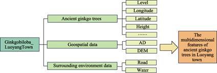
Figure 1 Technical roadmap for constructing the dataset
of Ginkgobiloba_LuoyangTown
4 Data Results and Validation
4.1 Data Composition
The dataset is archived in .shp, .xlsx, .jpg,
and .txt formats. For details regarding the data content and descriptions
represented by each field in the dataset of Ginkgobiloba_LuoyangTown (.shp) file,
please refer to Table 2.
Table 2
Composition of the dataset
|
Field names
|
Data content
|
Data description
|
|
ID
|
Number
|
Tree
number
|
|
Species/SpeciesCN
|
Tree
species
|
Tree
species (Latin/Chinese name)
|
|
Village/VillageCN
|
Village
name
|
Village
name
|
|
Longitude
|
Longitude
|
Longitude
of the geometric center of the ancient ginkgo tree
|
|
Latitude
|
Latitude
|
Latitude
of the geometric center of the ancient ginkgo tree
|
|
Height
|
Tree
height/m
|
Latitude
of the geometric center of the ancient ginkgo tree
Special
value*: 99.9 m
|
|
Level/LevelCN
|
Level
|
Grade 1: growth
exceeding 500 years;
Grade 2: growth
between 300 and 499 years;
Grade 3: growth
between 100 and 299 years[6]
|
|
Dbh
|
Diameter at breast height/cm
|
Diameter at
breast height (DBH) of the ancient ginkgo tree
|
|
Growth/GrowthCN
|
Growth status
|
Growth status of
the ancient ginkgo tree
|
*:
99.9 m indicates no data for tree height values.
4.2 Data Products
4.2.1 Tree Distribution
The spatial distribution
of ancient ginkgo trees in Luoyang town is illustrated in Figure 2. Latitude
and longitude geographic information were obtained for 2,036 trees more than a
century old. Predominantly, these trees are distributed in the southwest region
of Luoyang town.
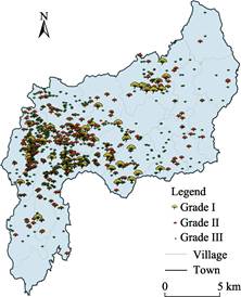
Figure 2 Distribution map of ancient ginkgo trees in Luoyang town
4.2.2 Statistical Evaluation
A
comprehensive analysis of the characteristics of the 2,036 ancient ginkgo trees
in Luoyang town was undertaken based on thorough
on-site surveys. By conducting in-depth interviews with residents and elderly
villagers residing near these trees, the ages of the trees were
estimated. According to the dataset, the minimum age of any
individual tree in the dataset is 100 years and the maximum age is
1,200 years with an average of 238.9 years. The minimum height of the trees is 4.7 m, the maximum height is 28.3 m, and the average height is 15.6 m.
The minimum diameter at breast height (DBH) is 52 cm and the maximum DBH is 880
cm, with an average of 224.7 cm.
The majority of
the trees fall within the age range of 100?C352 years, the height range of
4.7?C26.4 m, and the DBH range of 114?C411 cm. Notably, a correlation was
identified between the age, height, and DBH of the ancient trees, providing
valuable insights into their growth patterns and interdependencies.
4.2.3 Relationships with Altitude
The coupling and overlaying of the DEM data
with the spatial distribution dataset revealed a robust correlation with
altitude (Figure 4). Using the Extract Values to Points function, elevation
values were extracted for the locations of each tree in the dataset, and a
histogram depicting the height distribution of these trees was generated
(Figure 3). According to this analysis, ancient ginkgo trees in Luoyang town
are distributed at altitudes ranging from 50 to 450 m, with a concentration at
150?C250 m above sea level. Grouping the ancient trees based on altitude
revealed that these trees initiate growth above 76 m, with only 1.67%
distributed between 50 and 100 m above sea level. Thus, the number of ancient
ginkgo trees increases with altitude. A significant proportion of the trees,
14.03%, occur between 100 and 150 m above sea level, gradually increasing
within this altitudinal range, and the majority thrive between 150 and 200 m
(38.13%) and between 200 and 250 m (38.76%). The highest concentration of
ancient trees occurs at an altitude of approximately 188 m, while with a
further increase in altitude, the number sharply declines; trees found at
250?C300 m constitutes only 6.08% of the total records, representing an 84.31%
reduction compared to the previous altitudinal group. At even higher altitudes,
the number of trees decreases notably with proportions of 1.13%, 0.10%, and
0.10% for altitudes of 300?C350 m, 350?C400 m, and 400?C450 m, respectively. The
highest altitude at which a ginkgo tree was observed is 417 m (Table 3).
|
Table 3 Altitudes of the ancient ginkgo trees
in Luoyang town
|
Altitude (m)
|
Number of
ancient ginkgo trees
|
Percentage (%)
|
|
<50
|
0
|
0.00
|
|
50?C100
|
34
|
1.67
|
|
100?C150
|
286
|
14.03
|
|
150?C200
|
776
|
38.13
|
|
200?C250
|
789
|
38.76
|
|
250?C300
|
124
|
6.08
|
|
300?C350
|
23
|
1.13
|
|
350?C400
|
2
|
0.10
|
|
400?C450
|
2
|
0.10
|
|
>450
|
0
|
0.00
|
|
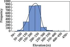
Figure 3 Altitudinal
distribution of ancient ginkgo trees in Luoyang town
|
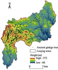
Figure 4 Distribution map of ancient ginkgo trees with
altitude in Luoyang town
4.2.4 Relationships with Slope
Terrain
slope directly influences soil fertility and water retention[7]. To
explore the relationship between the spatial distribution of the trees and slope,
extracted slope values were reclassified into the following six
categories: gentle (0???C5??), gradual (5???C15??), inclined (15???C25??), steep (25???C35??),
sharp (35???C45??), and hazardous (above 45??) slopes, aligning
with slope classification standards. Converting slope data into vector data, vector patches of the same
type were merged into the six categories. Based on spatial connection, the
numbers of ancient ginkgo trees after the classification were then determined.
According to the analysis, the trees are
mainly distributed on gradual slopes (5???C15??), accounting for 58.22% of the
overall distribution. With a decrease or increase in slope, the number of trees
gradually decreases; however, the number of trees on inclined slopes (15???C25??)
is relatively higher than that on gentle slopes (0???C5??), accounting for 27.25%
and 11.98%, respectively. With a further increase in slope angle, the numbers
of trees continue to decreases. Only 2.50% of ancient ginkgo trees are found on
steep slopes (25???C35??), and only one was recorded on a sharp slope (35???C45??),
with no occurrences on slopes > 45??. Thus, the distribution of these trees
in Luoyang town is closely related to the slope of the terrain (Table 4,
Figures 5 and 6).
|
Table 4 Slope statistics for the spatial
distribution of ancient ginkgo trees in Luoyang town
|
Slope
classification
|
Number of ancient
ginkgo trees
|
Percentage
(%)
|
|
Gentle slope
|
244
|
11.98
|
|
Gradual slope
|
1,185
|
58.22
|
|
Inclined slope
|
555
|
27.25
|
|
Steep slope
|
51
|
2.50
|
|
Sharp slope
|
1
|
0.05
|
|
Hazardous slope
|
0
|
0.00
|
|
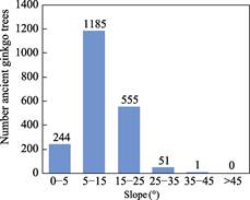
Figure 5 Slope distribution of ancient ginkgo
trees in Luoyang town
|

Figure 6 Distribution map of ancient ginkgo trees
with land slope in Luoyang town
4.2.5 Relationships with Slope
Aspect
Hilly
mountainous areas are considerably influenced by slope aspect, resulting in
distinct ecological environments, i.e., shady and sunny slopes, with a varying microclimate and ecological factors including light, heat, and water across slopes[8].
These differences directly impact the distribution, growth, development, yield,
and quality of forest plants. To investigate the relationships between
the spatial distribution of the trees and slope aspect, slope aspect was
represented by positive degrees from 0?? to 360??, measured clockwise
with north as the reference direction. Following standard procedures, the extracted slope aspect values were reclassified into the following
five categories:
0???C45?? (shady slope), 45???C135?? (semi-shady slope), 135???C225?? (sunny slope),
225???C315?? (semi-sunny slope), and 315???C360?? (shady slope). These categories
were converted into vector data, and patches of the same type were merged into
the aforementioned five categories. Through spatial connection, the numbers of
ancient ginkgo trees within each classification were then obtained (Table 5).
As depicted in Figure 7, the trees are
primarily distributed on semi-shady slopes followed by sunny slopes. However,
the distinction between shady and sunny slopes is not highly pronounced;
semi-shady, sunny, shady, and semi-sunny slopes account for 29.20%, 26.61%,
24.60%, and 19.59%, respectively.
Various slope aspects can lead to differences
in climatic conditions, such as sunlight, temperature, humidity, etc., between
shady and sunny slopes. However, these interactions are intricate, influenced
not only by latitude and longitude but also by the vertical height of the slope[9]. While this study solely explored the
correlation between the distribution of ancient ginkgo trees and slope, it is
evident that a certain correlation exists (Figures 7 and 8).
|
Table 5 Aspect statistics of the spatial
distribution of ancient ginkgo trees in Luoyang town
|
Aspect classification
|
Number of ancient ginkgo trees
|
Percentage
(%)
|
|
0???C45??(Shady slope)
|
257
|
12.62
|
|
45???C135??(Semi-shady slope)
|
595
|
29.20
|
|
135???C225??(Sunny slope)
|
541
|
26.61
|
|
225???C315??(Semi-sunny slope)
|
399
|
19.59
|
|
315???C360??(Shady slope)
|
244
|
11.98
|
|

Figure 7 Distribution of ancient ginkgo
trees in Luoyang town with slope aspect
|

Figure 8 Distribution map of ancient ginkgo trees with
aspect in Luoyang town
4.2.6 Relationships with
Waterbodies
Water
availability is the primary limiting factor for plant distribution and growth[10].
Environmental stressors such as drought, high temperatures, and low
temperatures can disrupt plant water metabolism, leading to cellular
dehydration and affecting crop growth. Ginkgo, growing in hilly and mountainous
areas, is particularly susceptible to water stress[11]. Therefore,
by extracting water system data for Luoyang town, we explored the relationships
between the distribution of the trees and their distance from waterbodies.
As shown
in Figure 9, the ancient ginkgo trees are clustered in the southwest. This clustering remains evident even in areas further away from waterbodies, while the regions closer to waterbodies
appear to support fewer
trees. The majority of the trees in the database are
distributed within 3,000?C7,000 m of waterbodies.
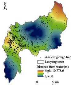
Figure 9 Distribution map of ancient ginkgo trees distance with distance from waterbodies
in Luoyang town
4.2.7 Relationships
with Roads
Ancient
trees and villages beautifully exemplify the seamless integration of nature and
human activities, showcasing a distinctive symbiotic relationship. This harmony
is evident not only in the preservation of the natural environment but also in
maintaining a delicate equilibrium between road construction and the
conservation of natural cultural heritage. Through the analysis of road data for Luoyang town, we aimed to explore the current interplay between the spatial distribution of these trees and transportation roads.
As depicted in Figure 10, numerous trees occur along
the main roads of villages in Luoyang town, standing out as prominent landmarks
in the local rural scenery. Going forward, local authorities can strategically
incorporate these ancient trees into cultural tourism routes through meticulous
planning, fostering the sustainable development of rural economies.
Simultaneously, in rural development initiatives, it is paramount to strike a
careful balance between safeguarding ancient ginkgo trees and the construction
of new transportation roads. Considering the current distribution of these
trees, preserving them, implementing sensible protective measures, and ensuring
that road construction has no adverse impacts are crucial components of this
delicate balance.
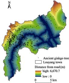
Figure 10 Distribution map of ancient ginkgo trees with
distance from road system in Luoyang town
5 Discussion and Conclusion
The
dataset of Ginkgobiloba_LuoyangTown stands out for its integration of diverse
data sources, drawing from comprehensive on-site investigations. This dataset
represents the world??s most densely populated, extensive, and well-preserved
community of ancient ginkgo trees. Through this dataset,
we analyzed the spatial distribution and influencing factors of existing trees in Luoyang town. This, in turn, enriches our understanding of the
regional distribution of ancient ginkgo trees in China and contributes to a
nuanced geographical perspective on the characteristics of ginkgo tree
populations.
The morphological characteristics, spatial
distribution, and factors influencing these trees can be summarized as follows:
(1) Luoyang town is home to a total of 2,036 ancient
ginkgo trees, for which latitude and longitude were obtained, which demonstrate
a relatively high quantity and density.
(2) The spatial distribution
of the trees is influenced by multiple factors such as
topography, elevation, waterbodies, and roads. These trees are primarily distributed in the southwest part of
Luoyang town, and their spatial distribution is
significantly affected by elevation and topography;
over 76% of the ancient ginkgo trees are located
150?C250 m above sea level, and more than 85% occur on gradual and inclined slopes.
It is important to note that
due to inherent limitations, there may be some bias and
omissions in the statistical analyses reported here. To
obtain more precise data, further collaboration with
local governments is essential. Future research directions include expanding
the research scope to a macro level, utilizing
technologies like artificial intelligence and remote sensing interpretation to
establish datasets for the ginkgo tree communities in
Luoyang town and nationwide. At a micro level, a combination of quantitative and
qualitative methods should be employed to analyze the local characteristics of
ginkgo tree distributions, with an emphasis on exploring the mechanisms behind
their spatial patterns.
Author Contributions
Huang,
Y. H. designed the dataset; Huang, Y. H. and Wang, Z. B. collected and
processed the spatial data; Huang, Y. H. designed the model and algorithms;
Huang, Y. H., Wang, Z. B., Wang, S. H., Xu, D. C., Li, X., and Zhou, J. Y.
performed data validation; Huang, Y. H., Wang, Z. B., Wang, S. H., Xu, D. C.,
Li, X., and Zhou, J. Y jointly wrote and revised the manuscript.
Conflicts of Interest
The
authors declare no conflicts of interest.
References
[1]
Deng, S. H. Palaeoclimatic
implications of main fossil plants of the Mesozoic [J]. Journal of Palaeogeography, 2007(6):
559‒574.
[2]
Lin, X. Origin and distribution
of ginkgo [J]. Bulletin of Biology,
1965(3): 32‒33.
[3]
Zhou, Y. L., Bao, J., Huang, H.
Q. Research of the Gingko??s primitive organisms' community in Suizhou Forestry
Bureau [J]. Hubei Forestry Science and
Technology, 1998(2): 35‒38.
[4]
Huang, Y. H., Wang, Z. B.,
Wang, S. H., et al. Tree by tree
dataset of ancient ginkgo biloba in Luoyang town, Suizhou, Hubei of China
(2023) [J/DB/OL]. Digital Journal of
Global Change Data Repository, 2024.
https://doi.org/10.3974/geodb.2024.01.03.V1.
https://cstr.escience.org.cn/CSTR:20146.11.2024.01.03.V1.
[5]
GCdataPR Editorial Office.
GCdataPR data sharing policy [OL]. https://doi.org/10.3974/dp.policy.2014.05
(Updated 2017).
[6]
Hubei Provincial People??s
Government. Regulations on the protection and management of ancient and famous
trees in Hubei province
[J]. Hubei
Provincial People??s Government
Gazette, 2010(13): 5‒7.
[7]
Chen, S. L. Discussion on the
slope degree and forestry measures in mountain hilly areas [J]. East China Forestry Manager, 2009,
23(1): 17‒21.
[8]
Zhang, Q. Q. Analysis of
ecological factors on mountain shady and sunny slopes [J]. Hunan Forestry Science and Technology,
1982(2): 27‒32.
[9]
Lin, C., Li, C. W. The
significance of aspect in mountain geographic [J]. Acta Geographica Sinica, 1985(1): 20‒28.
[10]
Bailey, R. G. Ecosystem
Geography [M/OL]. New York, NY: Springer New York, 1996. https://doi.org/10. 1007/978-1-4612-2358-0.
[11]
Jing, M., Cao, F. L., Wang, G.
B., et al. Influence of soil moisture
content on ginkgo growth and biomass allocation [J]. Journal of Nanjing Forestry University (Natural Science Edition), 2005(3): 5‒8.