1 km/5 day Surface Reflectance Data Product over China-ASEAN (2013)
Zhong, B.* Wu, S. L. Liu, Q. H.* Shan, X. J. Yang, A. X. Peng, J. J.
State Key Laboratory of Remote Sensing Science, Institute of Remote Sensing and Digital Earth, Chinese Academy of Sciences, Beijing 100101, China
Abstract: Land surface reflectance is a physical parameter demonstrating the reflectivity of the land surface at visible and near-infrared wavelength, and surface reflectance from remote sensing imagery is retrieved after its atmospheric effect is corrected. Surface reflectance is the pre-requisite for the quantitative applications of remote sensing imagery. The 1 km/5 day Surface Reflectance Data Product over China-ASEAN (2013) was developed by using the data from two MERSI sensors onboard FY3A&B satellites and two MODIS sensors onboard both Terra and Aqua together comprehensively, and all the data are processed using a normalized procedure including relative geo-registration, radiometric cross-calibration, spectral matching, and atmospheric correction. The spatial resolution is 1 km and the temporal frequency is 5 days. The validation of AOD instead of surface reflectance was carried on because AOD measurements can be accessed easier than surface reflectance. While validating the AOD, three different validations including the spatial distribution of AOD, the direct comparison between the retrieved AOD and the ground measurements from AERONET, and the comparison of the retrieved AOD from our study and the MODIS product were done. The results showed that the correlation coefficients reached 0.79 and 0.81 at Beijing and Xianghe stations respectively. The dataset has 40 tiles at Sinusoidal gridding system and each tile covers an area of 10°×10º. Each file has 4 bands including blue, green, red, and near-infrared band. They are all stored in integer data type .tif format and the scaling factor is 10,000. The dataset are compressed to 80 .rar files and the total data size is 19.33 GB.
Keywords: China, ASEAN, land surface reflectance, normalized processing, 5-day compositing, 1 km
1 Introduction
Land surface reflectance is a physical parameter demonstrating the reflectivity of the land surface at visible and near-infrared wavelength and surface reflectance from remote sensing imagery is retrieved after its atmospheric effect is corrected. Surface reflectance is the prerequisite for the quantitative applications of remote sensing imagery. Current surface reflectance products/datasets are produced using one type of remote sensing imagery and a 16-day composite product is usually provided in order to eliminate the cloud, whose frequency is not enough to demonstrate the change of vegetation at the growing season. Therefore, a 1 km/5 day surface reflectance product over ASEAN for 2013 was developed.
2 Metadata of Dataset
The metadata of the 1 km/5 day surface reflectance data product over China and the Association of Southeast Asian Nations (ASEAN) (2013) [1] is summarized in Table 1. It includes the dataset full name, short name, authors, emporal resolution, spatial resolution, data format, data size, data files, data publisher, and data sharing policy, etc.
Table 1 Summary of the metadata
|
Items
|
Description
|
|
Dataset full name
|
1 km/5 day surface reflectance product over China and the Association of Southeast Asian Nations for 2013
|
|
Dataset short name
|
MuSyQ-REF-1km-2013
|
|
Authors
|
Zhong, B. L-4528-2016, Institute of Remote Sensing and Digital Earth, Chinese Academy of Sciences, zhongbo@radi.ac.cn
Wu, S. L. S-1572-2016, Institute of Remote Sensing and Digital Earth, Chinese Academy of Sciences, wsl0579@163.com
Liu, Q. H. S-1647-2016, Institute of Remote Sensing and Digital Earth, Chinese Academy of Sciences, liuqh@radi.ac.cn
Shan, X. J. S-1589-2016, Institute of Remote Sensing and Digital Earth, Chinese Academy of Sciences, shanxj@radi.ac.cn
Yan, A. X. R-9028-2016, Institute of Remote Sensing and Digital Earth, Chinese Academy of Sciences, yangax@radi.ac.cn
Peng, J. J. S-1261-2016, Institute of Remote Sensing and Digital Earth, Chinese Academy of Sciences, rspeggy@163.com
|
|
Geographical region
|
Geographical region: 10°55′12″S-53°32′24″N, 73°37′12″E-141°0′36″E. It includes China, Indonesia, Malaysia, the Philippines, Singapore, Thailand, Brunei, Vietnam, Laos,
Myanmar, and Cambodia
|
|
Time
|
2013
|
|
Temporal resolution
|
5 d Spatial resolution 1 km
|
|
Number of tiles
|
40 Data format .tif
|
|
Data Size
|
26.62 GB (19.33 GB in .rar file)
|
|
Dataset and data files
|
The MuSyQ-REF-1km-2013 product was produced in the Sinusoidal tile grid, and distributed in 40 adjacent non-overlapping tiles that are approximately 10°×10° (at the equator). Each file have 4 bands, They are:
1. Band_1, represent the blue band of the surface reflectance
2. Band_2, represent the green band of the surface reflectance
3. Band_3, represent the red band of the surface reflectance
4. Band_4, represent the near infrared band of the surface reflectance
|
|
Foundation(s)
|
Ministry of Science and Technology of P. R. China (2012AA12A304, 2013AA12A301)
|
|
Data publisher
|
Global Change Research Data Publishing and Repository, http://www.geodoi.ac.cn
|
|
Address
|
No. 11A, Datun Road, Chaoyang District, Beijing 100101, China.
|
|
Data sharing policy
|
Data from the Global Change Research Data Publishing & Repository includes metadata, datasets (data products), and publications (in this case, in the Journal of Global Change Data & Discovery). Data sharing policy includes: (1) Data are openly available and can be free downloaded via the Internet; (2) End users are encouraged to use Data subject to citation; (3) Users, who are by definition also value-added service providers, are welcome to redistribute Data subject to written permission from the GCdataPR Editorial Office and the issuance of a Data redistribution license; and (4) If Data are used to compile new datasets, the ‘ten per cent principal’ should be followed such that Data records utilized should not surpass 10% of
the new dataset contents, while sources should be clearly noted in suitable places in the new
dataset[2]
|
3 Methods
The procedure to produce the 1 km/5 day surface reflectance product includes 4 steps:
1) Radiometric calibration: transfer the DN value to TOA radiance or TOA reflectance.
|

Figure 1 The flowchart of the procedure.
|
2) Geo-registration: use MODIS imagery as referencing data to register the other data geographically.
3) Atmospheric correction: remove the atmospheric effect and retrieve the surface reflectance.
4) 5-day composite: collect all the surface reflectance data from 2 MERSIs and 2 MODISs within 5 days to composite a 5-day surface reflectance, which are hardly influenced by clouds.
The flowchart of the procedure to produce the 1 km/5 day surface reflectance using multi-sensor data is presented in Figure 1.
3.1 Radiometric Calibration
|
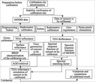
Figure 2 The flowchart of the cross-calibration procedure
|
Radiometric calibration is a process transferring DN of remote sensing imagery to radiance or reflectance. The radiance or reflectance from different instrument should be consistent; however, they have difference due to the materials, the manufactural technology, and so on. In this study, remotely sensed images from multiple instruments including Terra/MODIS,
Aqua/MODIS, MERSI/FY3A, and MERSI/FY3B are used in a synergized way, so the radio-
metric consistency is extremely important. Since MODIS has in-orbit calibrating system and it has been documented as one of the sensors with the best radiation capability, it was used as the reference to cross-cali-
brate the MERSIs. Therefore, in order to reduce the radiometric difference as much as possible, cross-calibration methods are developed[3–5]. The procedure of the cross-calibration method is as follows (Figure 2).
The cross-calibration procedure includes preparation, pre-processing, cross-calibration, and validation.
1) Considering the distance between the sun and the earth, the solar and viewing geometry and the land surface difference in summer and winter, the apparent reflectance of MODIS time series at the calibration site in summer and winter are made respectively.
2) Sort out the time series in summer and winter and the minimums at blue band is singled out as the clear pixels.
3) The clear pixels are used to simulate the BRDF in both summer and winter after
atmospheric correction. In this study, the Staylor-Suttles model[6] is chosen for BRDF simulation. In addition, the AOD are also retrieved simultaneously.
|
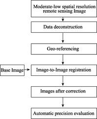
Figure 3 The flowchart of the geo-registration method.

Figure 4 The flowchart of the
image-to-image registration method.
|
4) The simulated BRDFs are used to calculate the surface reflectance of the MODIS
imagery which is not clear.
5) The TOA reflectance is simulated using MODTRAN, its inputs are the AOD from step (3), the water vapor content from MOD05, DEM, the geometry, and the simulated surface reflectance.
6) Calculate the radiometric calibration coeffi-
cients by comparing the simulated TOA reflectance and the DN imagery.
3.2 Geometric Registration
Since Level 1B data store only the scanned data which are not geo-registered, they need to be geo-referenced using the geo-location data within Level 1B data at the first place. Since the accuracy of the geo-location data are not high enough, an image-to-image registration procedure is proposed in this study. The base image is made using the 500 m MOD09A1 product, which is 8-day composite and almost clear. The terrain correction is done using the ASTER global DEM product. The geo-registration procedure is illustrated in Figure 3.
The major processes are as follows:
1) Data deconstruction
Several data have been used in this study and the storing structures of Level 1B are different, so some of the information needs to be read and used as the inputs for reformatting the data into standard format.
2) Geo-referencing
Use the geo-location data extracted from the Level 1B data to transfer the scanned data to the geo-referenced data.
3) Image-to-image registration
Using the large ground features, such as sea shores, large lake contours, and large rivers as the controlling points, image to image registration method was used for the MODIS base images in 500 m resolution. The flowchart of the image-to-image registration method is presented in Figure 4. The major processes include data pre-processing, contour extracting, contour matching, error matching points removing, transform model estimation, and resampling.
3.3 Atmospheric Correction
In this study, an atmospheric correction approach simulating the vegetation growing process is proposed. Considering a whole year MODIS data at blue band, the TOA reflectance at clear days are usually the smallest ones and all the smallest ones at different stages reflect the tendency of the surface reflectance; therefore, the atmospheric correction can be easily done based on this approach. The flowchart of this method is presented in Figure 5.

Figure 5 The flowchart of the atmospheric correction method.
4 Dataset Compositions, Quality Control and Validation
The data from multiple instruments within 5 days were used to composite a 5-day surface reflectance product after processed using the approaches proposed at section 3.
4.1 Dataset: 1 km/5 day Surface Reflectance Data Product
Figure 6 shows an example of the 1 km/5 day Surface Reflectance Data Product over China- ASEAN. It contains less clouds, the temporal frequency is improved to 5 days compared to that of the MODIS surface reflectance, 8 days.
4.2 Data Validation
4.2.1 The Procedure for Validation
Since the direct validation of surface reflectance is very difficult, the AODs retrieved in the atmospheric correction stage are validated instead of surface reflectance in this study. The validation of AODs includes three parts: 1) the spatial tendency of AOD checking, 2) the direct comparison to the AODs measured from AERONET (Aerosol Robotic Network), and 3) the comparison to the MODIS AOD product. The procedure is illustrated in Figure 7.
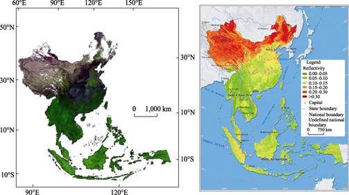
Figure 6 An example of the 1 km/5 day surface reflectance product over China and the Association of Southeast Asian Nations (ASEAN). (a) is the true color composite at December 2-6, 2013;
(b) is the surfacereflectance at red band.
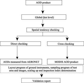
Figure 7 The procedure of validation of the AODs
4.2.2 The Data for Validation
The data for validation include MODIS TOA reflectance, AODs measured from the AERONET, and the AOD product of MODIS.
4.2.3 Validation Results
First, the spatial patterns of the MODIS TOA (Figure 8) and the retrieved AOD in this study (Figure 9) are compared, which looks fairly consistent.
After the spatial tendency checking, the AOD retrieved for a whole year at Beijing and Xianghe stations are compared to the AODs measured from AERONET. The scattering plots are presented in Figure 10. The comparisons show that the correlation coefficients are 0.79 and 0.81 respectively, and the RMSEs are 0.131 and 0.24, respectively, at Beijing and Xianghe stations.
Finally, the retrieved AOD (Figure 9) is compared with the MODIS AOD (Figure 11). The comparison demonstrates several advantages of the retrieved AODs over MODIS AOD: 1) the spatial resolution is higher, 2) spatially much more complete, and 3) the AODs retrieved in sparsely vegetated areas are more reasonable.
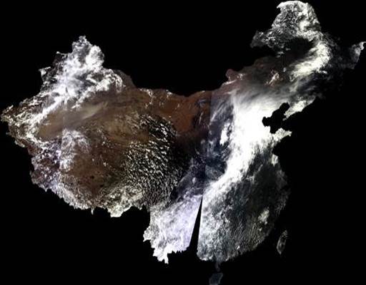
Figure 8 The true color composite of the TOA reflectance of MODIS.
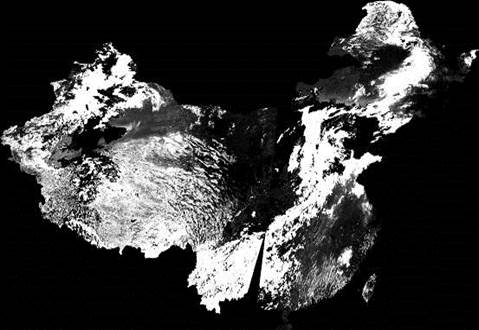
Figure 9 The retrieved AOD corresponding to the data showing in Figure 8 in this study.

Figure 10 The comparisons between the retrieved AODs and the measured AODs from the AERONET.
5 Discussion and Conclusion
Based on the results and validation at section 4, the proposed procedure for normalizing the remotely sensed data from multiple instruments is successful. The 1 km/5 day surface reflectance composited using the multi-source remote sensing data are almost no clouds, which has the highest frequency and has very important meaning for the retrieving of the bio-geophysical parameters quantitatively.
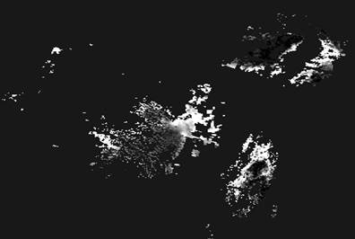
Figure 11 The AODs from the MODIS product, which is corresponding to the same MODIS data in Figure 8
Author Contributions
Zhong, B. and Liu, Q. H. designed the development of this dataset. Zhong, B. wrote the data paper. Zhong, B., Wu, S. L., Shan, X. J., Yang, A. X. and Peng, J. J. contributed to the data processing and analysis. Wu, S. L. did the validation.
Acknowledgements
The MODIS data were downloaded from NASA, the FY3/MERSI data were provided by the China Meteorological Administration, and the AOD data for validation are downloaded from NASA’s AERONET website.
References
[1] Zhong, B., Wu, S. L., Liu, Q. H., et al. 1 km/5 day surface reflectance product over China and the Association of Southeast Asian Nations for 2013 [DB/OL]. Global Change Research Data Publishing & Repository, 2015. DOI:10.3974/geodb.2015.02.02.V1
[2] GCdataPR Editorial Office. GCdataPR Data Sharing Policy [OL]. DOI: 10.3974/dp.policy.2014.05 (Updated 2017).
[3] Huang, H. X. The method study of cross-calibration for Moderate and Low-resolution remote sensing satellites reflectance bands based on series imagery [D]. Qingdao: China University of Petroleum, 2011.
[4] Yang, A. X. Research on cross radiometric calibration of moderate and low resolution data based on MODIS [D]. Chongqing: Chongqing University of Posts and Telecommunications, 2014.
[5] Staylor, W. F., Suttles, J. T. Reflection and emission models for deserts derived from Nimbus-7 ERB scanner measurements [J]. Journal of climate and applied meteorology, 1986, 25(2): 196-202.
[6] Zhong, B., Yang, A. X., Wu, S. L., et al. Cross-calibration of reflective bands of major moderate resolution remotely sensed data [J]. Remote Sensing of Environment, 2018, 204(1): 412-423.