Gui,
D. W.1,2* Lin, J. W.1,2 Liu, Y. F.1,3 Liu, Q.1,3 Abd-Elmabod, S. K.4
Ahmed, Z.1,3 Liu, C.5*
1. Xinjiang
Institute of Ecology and Geography, Chinese Academy of Sciences, Urumqi 830011,
China;
2. University of Chinese Academy of Sciences, Beijing 100049, China;
3. Cele
National Station of Observation and Research for Desert-Grassland Ecosystems,
Cele 848300, China;
4. Soils & Water Use
Department??Agricultural and Biological Research Institute, National
Research Centre, Cairo 12622, Egypt;
5. Institute of Geographic Sciences and
Natural Resources Research, Chinese Academy of Sciences, Beijing 100101, China
Abstract:
Oases are non-zonal geographical
units formed on a desert matrix in arid regions driven by stable water sources.
They serve as crucial habitats for biodiversity, bases for human livelihoods,
and important pillars of human civilization. Oases play a pivotal role in
maintaining the stability of terrestrial ecosystems in arid zones, preventing
land degradation, regulating local climates, and enhancing ecological
well-being. However, fundamental research on the global distribution digital
data of oases is still lacking, and systematic global oasis cataloging has not
yet been established. This has caused significant discrepancies and gaps in the
available data, resulting in inconsistencies and inaccuracies in numerous
related studies, thereby hindering the progress in oasis science. To fill this
gap, this data product, based on high-resolution remote sensing imagery
provided by the Google Earth Pro platform, manually delineated global oasis
boundaries through visual interpretation. A global oasis dataset was created
using 2020 as the baseline year, and the first comprehensive global oasis
catalog was systematically completed. The dataset, comprising a total of 54
files, has been published in the Global Change Research Data Publishing &
Repository the regular member of World Data System of the International Science
Council and is freely available for download globally. The research results
show that oases are distributed across 5 continents and 54 countries, covering
a total area of 2,482,193.27 km² and encompassing 4,850 oases. Among them,
China has the largest area (275,535.39 km²) of oases, containing 1,398 oases.
Based on this high-precision dataset, we selected the most relevant four
attributes (continent, country, river, and oasis area)—to code the global
oases. Each oasis larger than 1 km² was assigned a unique ID, thereby
establishing a clear ??identity?? for each oasis and addressing the long-standing
absence of a global cataloging system. Moreover, regular future updates related
to the catalog information will enable the precise tracking of dynamic
processes such as oasis expansion and contraction, providing a quantitative
basis for the scientific assessment of ecosystem health and evolutionary
trends.
Keywords: oasis; global; spatial distribution; cataloging; dataset
DOI: https://doi.org/10.3974/geodp.2025.03.01
1 Introduction
Arid zone constitutes a critical component of the Earth??s
geographical system, covering approximately 41% of the global land surface and
supporting the survival of more than 2.5 billion people[1]. Within
these regions, oases represent unique socio-ecological landscapes[2],
formed on desert matrices due to stable water sources[3]. Oases hold
significant ecological, social, and cultural value globally, playing
irreplaceable roles in sustaining biodiversity, maintaining ecological
integrity, and preserving cultural heritage[4]. Their stability is
essential not only for the well-being of local communities but also for
regional ecosystem health and economic sustainability[5]. Given
their high degree of local specificity, global conservation strategies for
oases are urgently needed, consistent with the principles promoted by UNESCO,
UNEP (2002), the Millennium Ecosystem Assessment (2005), and the
Intergovernmental Science-Policy Platform on Biodiversity and Ecosystem
Services (2019)[6].
Despite
their importance, global research on oases remains insufficient. The most
pressing challenge lies in the unresolved question of their global
distribution, which has led to an unclear baseline and inconsistent data.
Existing studies primarily focus on specific river basins[7,8] or
individual countries[9,10], leaving the exact global number, area,
and spatial distribution of oases largely unknown. Furthermore, the absence of
publicly available, freely accessible global datasets has significantly limited
quantitative analyses and hindered the systematic development of oasis science.
Systematic
classification and cataloging of geographical units constitute the foundation
of geographical research and are prerequisites for understanding spatial
distribution and evolutionary patterns[11]. As non-zonal
geographical units in arid regions, oases also require systematic cataloging.
Such cataloging effectively establishes an ??oasis register??, documenting the
location, extent, and core hydrological and ecological attributes of each
oasis. These baseline data are essential for analyzing oasis ecosystem
structures, their functional dynamics, and their interactions with surrounding
desert environments. At a broader scale, cataloging can uncover potential
linkages among dispersed patches of oasis, providing evidence for ecological
corridor planning, species migration, and gene flow[12]. This
contributes to enhancing connectivity and resilience within regional ecological
networks and mitigating habitat fragmentation risks under climate change.
However, the lack of baseline data has long prevented systematic cataloging at
the global scale, leaving the framework of oasis science incomplete.
To
address this issue and bridge the gap, the current study adopted 2020 as the
baseline year and utilized high-resolution summer imageries from Google Earth
Pro as the primary data source. Over a span of 5-years, more than 30
geographers conducted detailed visual interpretation to delineate oasis
boundaries, resulting in the construction of a global oasis dataset with high
precision. This dataset comprehensively clarifies the number and area of oases
worldwide, thereby providing reliable baseline information for subsequent
ecological research and management. Based on this dataset, we developed
systematic coding rules to establish the first global oasis catalog, thereby
filling a long-standing gap in oasis research. Importantly, the dataset and
cataloging results are freely available under the framework of the ??Open
Science?? initiative, making a significant contribution to the advancement and
enrichment of oasis science.
2 Methods
2.1 Data
Sources
The
data used in this study mainly included remote sensing imageries, global arid
zoning data, national administrative boundary data, global watershed data, and
global vegetation cover data. The remote sensing imageries are primarily
sourced from Google Earth Pro, which provides a very high spatial resolution,
reaching sub-meter levels. The global arid zoning data were obtained from the
United Nations Environment Programme World
Conservation Monitoring Centre,
offering an authoritative basis for the regional division of arid zones. The
national administrative boundary data were derived from the Global
Administrative Unit Layers (GAUL) database,
which provided detailed administrative boundary information for countries and
regions worldwide. It should emphasize that this boundaries for scientific
research reference only, not for politics argument between countries. The
global watershed data were taken from relevant research published in Scientific
Data[13], covering watershed information on a global scale. The
global land cover data were sourced from the European Space Agency (ESA) global
land cover product,
with a spatial resolution of 10 m, which effectively supports the monitoring
and analysis of land use and environmental change.
2.2 Data Extraction Method
Although existing studies have proposed semi-automatic[14,15]
or fully automatic[16,17] methods for feature extraction, these
technologies still face challenges such as unstable classification accuracy and
blurry boundaries when dealing with the spatial heterogeneity of internal
vegetation types within oases (e.g., mixed distribution of different crop
types, shrubs, and trees) and the morphological diversity of oasis boundary
patterns (e.g., gradual transition zones along river edges, intermingled zones between farmland and desert). To ensure
the consistency and high quality of the oasis boundary data, the visual
interpretation method[18], combined with spatial validation in a
Geographic Information System (GIS), was ultimately adopted to establish a
rigorous technical workflow (Figure 1).
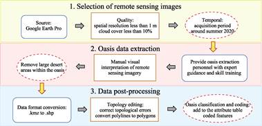
Figure 1 Technical roadmap of the
dataset development
The workflow of the
dataset development is shown as follows:
(1)
Image selection: Summer remote sensing images of 2020 were selected because
this period featured vigorous vegetation growth with a high Leaf Area Index
(LAI) and no snow interference, providing a high-contrast visual basis for
visual interpretation.
(2)
Image examination: The images were examined using multi-level zooming on the
Google Earth Pro platform, with a requirement that the viewing altitude be
below 1.5 km and the spatial resolution better than 1 m to clearly display the
fine details of the oasis edge (such as the crown morphology of vegetation and
farmland boundaries).
(3)
Pixel-by-pixel interpretation: Based on the actual ground conditions and with
vegetation cover data as auxiliary information, each pixel was interpreted to
classify different land use types (e.g., water bodies, bare land, farmland,
desert). Control points were precisely set using the platform??s mapping tools,
and the oasis boundary was exported in .kmz format.
(4) GIS validation and conversion: The .kmz file was then imported into ArcGIS 10.8, converted into
a .shp format vector file, and a spatial topological
relationship check was executed.
(5) Final processing:
The validated polyline boundary data was subsequently converted into a
polygonal (polygon) file. Basic geographic information was added to the
attribute table, and patches smaller than 0.01 km2 were removed to
eliminate noise interference, thereby more accurately representing the overall
spatial extent and geographic characteristics of the oasis.
2.3 Coding
System
To
enable the scientific identification, classification, and management of global
oases, this study developed a multi-level and multi-dimensional coding system,
assigning a unique ID to each oasis. Considering that very small oases are
highly vulnerable to environmental changes and tend to display greater
randomness in their evolution, only oases with an area larger than 1 km2
were selected for coding in order to improve the accuracy and practicality of
the system.
During the selection of
coding fields, several alternative designs were initially evaluated. For
example, a ??water source?? field could have been introduced to distinguish
between oases primarily driven by surface water and those sustained by
groundwater. Similarly, a ??climate attribute?? field could have been considered
to differentiate oases in cold desert versus hot desert environments. However,
these attributes were not adopted because they are difficult to define
consistently across all oases and may introduce ambiguity.
Following expert
consultation, the final oasis ID was generated through hierarchical coding
based on four of the most representative attributes: continent, country, basin,
and area (Figure 2).
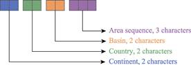
Figure 2 Schematic of global oasis coding system
Continent field (2
characters): This is the first-level and highest hierarchical field, directly
indicating the continent in which the oasis is located. As a geographic unit
above the national level, the continent field not only establishes a clear
hierarchical framework but also enables progressive aggregation and drill-down
analyses from the continental to the national level in both statistical and
spatial queries. This significantly improves the efficiency of data aggregation
and retrieval. Furthermore, defining this field avoids ambiguities arising from
countries that span multiple continents or special geographic divisions,
thereby reducing redundancy caused by repeated mapping logic. Globally, oases
are distributed across Asia, Africa, North America, South America, and Oceania,
with the corresponding codes in the oasis ID being AS, AF, NA, SA, and OA,
respectively.
Country
field (2 characters): This is the second-level field, specifying the country or
countries containing the specific oasis. The inclusion of the country field
highlights the central role of the national level in the governance and
development of oases. National boundaries define the administrative affiliation
and spatial extent of each oasis, forming the institutional foundation for its
internal and external spatial organization. Globally, oases are distributed
across 54 countries, including typical oasis regions such as China, the United
States, Egypt, and Pakistan. In the coding process, each country is represented
by a two-letter English code defined by the International Organization for
Standardization (ISO), ensuring both standardization and international
compatibility of the data structure. In cases where an oasis spans multiple
countries, the first character of this field denotes the number of countries
involved, while the second character is encoded sequentially according to the
relative geographic positions of the countries, following an order from
northeast to southwest (Table 1).
Table
1 Oasis ID country code system
|
Country
name
|
Country
ID
|
Country
name
|
Country
ID
|
|
Algeria
|
DZ
|
Tajikistan
|
TJ
|
|
Egypt
|
EG
|
Turkey
|
TR
|
|
Ethiopia
|
ET
|
Turkmenistan
|
TM
|
|
Angola
|
AO
|
Uzbekistan
|
UZ
|
|
Kenya
|
KE
|
Syria
|
SY
|
|
Libya
|
LY
|
Armenia
|
AM
|
|
Mali
|
ML
|
Yemen
|
YE
|
|
Mauritania
|
MR
|
Iraq
|
IQ
|
|
Namibia
|
NA
|
Iran
|
IR
|
|
Sudan
|
SD
|
Israel
|
IL
|
|
Somalia
|
SO
|
Jordan
|
JO
|
|
South Africa
|
ZA
|
China & Kazakhstan
|
2A
|
|
Afghanistan
|
AF
|
Turkmenistan & Uzbekistan
|
2B
|
|
Kyrgyzstan
|
KG
|
Turkmenistan & Afghanistan
|
2C
|
|
Kuwait
|
KW
|
Afghanistan & Tajikistan
|
2D
|
|
Lebanon
|
LB
|
Afghanistan & Iran
|
2E
|
|
Tunisia
|
TN
|
Pakistan & Iran
|
2F
|
|
Niger
|
NE
|
Azerbaijan & Iran
|
2G
|
|
Nigeria
|
NG
|
Kuwait & Saudi Arabia
|
2H
|
|
Senegal
|
SN
|
Syria & Jordan
|
2I
|
|
Chad
|
TD
|
Israel & Jordan
|
2J
|
|
Argentina
|
AR
|
United Arab Emirates & Saudi Arabia
|
2K
|
|
Bolivia
|
BO
|
United Arab Emirates & Oman
|
2L
|
|
Peru
|
PE
|
Oman & Saudi Arabia
|
2M
|
|
Chile
|
CL
|
Saudi Arabia & Yemen
|
2N
|
|
United States
|
US
|
Egypt & Libya
|
2O
|
|
Mexico
|
MX
|
Algeria & Tunisia
|
2P
|
|
Australia
|
AU
|
Algeria & Morocco
|
2Q
|
|
Eritrea
|
ER
|
Eritrea & Sudan
|
2R
|
(To be continued on the next page)
(Continued)
|
Country
name
|
Country
ID
|
Country
name
|
Country
ID
|
|
Cape Verde
|
CV
|
Ethiopia & Somalia
|
2S
|
|
Djibouti
|
DJ
|
Niger & Mali
|
2T
|
|
Cameroon
|
CM
|
Mali & Mauritania
|
2U
|
|
Morocco
|
MA
|
Mauritania & Senegal
|
2V
|
|
United Arab Emirates
|
AE
|
Namibia & South Africa
|
2W
|
|
Oman
|
OM
|
United States & Mexico
|
2X
|
|
Azerbaijan
|
AZ
|
Syria & Israel & Jordan
|
3A
|
|
Pakistan
|
PK
|
Kazakhstan & Kyrgyzstan & Uzbekistan
& Tajikistan
|
4A
|
|
Bahrain
|
BH
|
Uzbekistan & Tajikistan & Afghanistan
& Turkmenistan
|
4B
|
|
Kazakhstan
|
KZ
|
Turkey & Armenia & Azerbaijan &
Iran
|
4C
|
|
Qatar
|
QA
|
Niger & Chad & Cameroon & Nigeria
|
4D
|
|
Mongolia
|
MN
|
Iran & Iraq & Kuwait & Turkey &
Syria & Lebanon
|
6A
|
|
Saudi Arabia
|
SA
|
|
|
|
|
|
|
|
Basin field (2
characters): This is the third-level field, used to further
identify the watershed to which an oasis belongs. The rationale for selecting
the watershed as a coding field lies in the fundamental importance of water
resources as water is the lifeline of oases, shaping their ecosystems,
sustaining vegetation cover, and supporting human society. In practice, an
oasis is typically associated with one or multiple watersheds. For consistency
and clarity, this study designated the primary watershed that sustains the
oasis as the identifier for this field. The coding rules for watersheds are
adapted from existing global watershed classification systems, with necessary
modifications to address the specific characteristics and requirements of
oases. The correspondence between global watershed codes and the oasis codes
applied in this study is presented in Table 2.
Table
2 Global basin code and oasis ID code
cross-reference
|
Global
basin code
|
Oasis
ID
code
|
Global
basin code
|
Oasis
ID
code
|
Global
basin code
|
Oasis
ID
code
|
Global
basin code
|
Oasis
ID
code
|
|
21A
|
01
|
53A
|
27
|
25G
|
14
|
55A
|
40
|
|
22B
|
02
|
53B
|
28
|
25H
|
15
|
55B
|
41
|
|
23A
|
03
|
53D
|
29
|
25I
|
16
|
56A
|
42
|
|
24A
|
04
|
53E
|
30
|
25J
|
17
|
56B
|
43
|
|
24B
|
05
|
53F
|
31
|
42B
|
18
|
56C
|
44
|
|
24C
|
06
|
53G
|
32
|
42C
|
19
|
64A
|
45
|
|
24D
|
07
|
53H
|
33
|
42F
|
20
|
65A
|
46
|
|
25A
|
08
|
53J
|
34
|
42G
|
21
|
72B
|
47
|
|
25B
|
09
|
53K
|
35
|
43B
|
22
|
72C
|
48
|
|
25C
|
10
|
54A
|
36
|
43C
|
23
|
73D
|
49
|
|
25D
|
11
|
54C
|
37
|
45A
|
24
|
73I
|
50
|
|
25E
|
12
|
54D
|
38
|
45B
|
25
|
75A
|
51
|
|
25F
|
13
|
54E
|
39
|
45C
|
26
|
|
|
Area field (3
characters): This is the fourth and final hierarchical field. Since a single
watershed may contain multiple oases, a three-character format is adopted to
accommodate cases where numerous oases exist within the same watershed. Within
each watershed, oases are ranked by area, with the largest assigned the code
001, followed sequentially by smaller ones. This field ultimately defines the
relative status of an oasis within its watershed.
The area field was
selected because the size of an oasis is a critical determinant of its
significance. It serves not only as a spatial quantitative indicator but also
as an important parameter with cross-disciplinary relevance in ecology,
sociology, and resource management. For example, the area of an oasis
influences its capacity to sustain ecosystems and is directly related to the
distribution and availability of water resources. In contrast, smaller oases
are more vulnerable in terms of water resource allocation and carrying
capacity, making them more susceptible to external environmental changes.
3 Results
3.1 The Global Oases Dataset
This
study produced a total of 54 oasis datasets[18–71] and a global
oasis code table. The datasets are archived in .kmz
and .shp formats. All datasets have been published on
the Global Change Research Data Publishing & Repository and are available
for free download globally. The specific list of datasets is shown in Table 3.
Table
3 Overview of global oasis entries publication
|
Oasis
Name
|
DOI
|
Data
size
|
Data formats
|
|
Egyptian Oasis
|
10.3974/geodb.2025.02.10.V1
|
649
MB
|
.kmz, .shp
|
|
Ethiopian Oasis
|
10.3974/geodb.2025.03.10.V1
|
22.5
MB
|
.kmz, .shp
|
|
Algerian Oasis
|
10.3974/geodb.2025.04.07.V1
|
730
MB
|
.kmz, .shp
|
|
Angolan Oasis
|
10.3974/geodb.2025.04.08.V1
|
31 MB
|
.kmz, .shp
|
|
Libyan Oasis
|
10.3974/geodb.2025.04.09.V1
|
255
MB
|
.kmz, .shp
|
|
Malian Oasis
|
10.3974/geodb.2025.04.10.V1
|
60.8
MB
|
.kmz, .shp
|
|
Mauritanian Oasis
|
10.3974/geodb.2025.04.11.V1
|
94.4
MB
|
.kmz, .shp
|
|
Kenyan Oasis
|
10.3974/geodb.2025.04.12.V1
|
15.1
MB
|
.kmz, .shp
|
|
Namibian Oasis
|
10.3974/geodb.2025.05.03.V1
|
7.98
MB
|
.kmz, .shp
|
|
South African Oasis
|
10.3974/geodb.2025.05.04.V1
|
10.6
MB
|
.kmz, .shp
|
|
Sudanese Oasis
|
10.3974/geodb.2025.05.06.V1
|
392
MB
|
.kmz, .shp
|
|
Somali Oasis
|
10.3974/geodb.2025.05.07.V1
|
12.3
MB
|
.kmz, .shp
|
|
Tunisian Oasis
|
10.3974/geodb.2025.06.02.V1
|
180
MB
|
.kmz, .shp
|
|
Afghan Oasis
|
10.3974/geodb.2025.06.03.V1
|
680
MB
|
.kmz, .shp
|
|
Kyrgyzstani Oasis
|
10.3974/geodb.2025.06.04.V1
|
249
MB
|
.kmz, .shp
|
|
Kuwaiti Oasis
|
10.3974/geodb.2025.06.06.V1
|
28.1
MB
|
.kmz, .shp
|
|
Lebanese Oasis
|
10.3974/geodb.2025.06.07.V1
|
9.20
MB
|
.kmz, .shp
|
|
Peruvian Oasis
|
10.3974/geodb.2025.06.08.V1
|
332
MB
|
.kmz, .shp
|
|
Chilean Oasis
|
10.3974/geodb.2025.06.09.V1
|
84.9
MB
|
.kmz, .shp
|
|
Argentine Oasis
|
10.3974/geodb.2025.07.05.V1
|
116
MB
|
.kmz, .shp
|
|
Australian Oasis
|
10.3974/geodb.2025.07.06.V1
|
123
MB
|
.kmz, .shp
|
|
Bolivian Oasis
|
10.3974/geodb.2025.07.07.V1
|
7.29
MB
|
.kmz, .shp
|
|
|
|
|
|
(To be continued on the next page)
(Continued)
|
Oasis
Name
|
DOI
|
Data
size
|
Data formats
|
|
Mexican Oasis
|
10.3974/geodb.2025.07.08.V1
|
262
MB
|
.kmz, .shp
|
|
Syrian Oasis
|
10.3974/geodb.2025.07.09.V1
|
32.6
MB
|
.kmz, .shp
|
|
Yemeni Oasis
|
10.3974/geodb.2025.07.10.V1
|
202
MB
|
.kmz, .shp
|
|
Israeli Oasis
|
10.3974/geodb.2025.07.11.V1
|
21.3
MB
|
.kmz, .shp
|
|
Southwestern American Oasis
|
10.3974/geodb.2025.07.12.V1
|
1.04
GB
|
.kmz, .shp
|
|
United Arab
Emirates Oasis
|
10.3974/geodb.2025.07.13.V1
|
52.6
MB
|
.kmz, .shp
|
|
Omani Oasis
|
10.3974/geodb.2025.07.14.V1
|
121
MB
|
.kmz, .shp
|
|
Azerbaijani Oasis
|
10.3974/geodb.2025.07.15.V1
|
11.6
MB
|
.kmz, .shp
|
|
Pakistani Oasis
|
10.3974/geodb.2025.08.05.V1
|
670
MB
|
.kmz, .shp
|
|
Bahraini Oasis
Eritrean Oasis
Cape Verdean Oasis
Djiboutian Oasis
Kazakhstani Oasis
Qatari Oasis
Mongolian Oasis
Saudi Arabian Oasis
Turkish Oasis
Turkmen Oasis
Uzbek Oasis
Armenian Oasis
Iraqi Oasis
Iranian Oasis
Jordanian Oasis
Chadian Oasis
Cameroonian Oasis
Moroccan Oasis
Nigerien Oasis
Nigerian Oasis
Senegalese Oasis
Tajik Oasis
Chinese Oasis
|
10.3974/geodb.2025.08.06.V1
10.3974/geodb.2025.08.11.V1
10.3974/geodb.2025.08.12.V1
10.3974/geodb.2025.08.13.V1
10.3974/geodb.2025.08.14.V1
10.3974/geodb.2025.08.15.V1
10.3974/geodb.2025.08.16.V1
10.3974/geodb.2025.08.17.V1
10.3974/geodb.2025.08.18.V1
10.3974/geodb.2025.08.19.V1
10.3974/geodb.2025.08.20.V1
10.3974/geodb.2025.08.21.V1
10.3974/geodb.2025.08.22.V1
10.3974/geodb.2025.09.03.V1
10.3974/geodb.2025.09.04.V1
10.3974/geodb.2025.09.05.V1
10.3974/geodb.2025.09.07.V1
10.3974/geodb.2025.09.08.V1
10.3974/geodb.2025.09.09.V1
10.3974/geodb.2025.09.10.V1
10.3974/geodb.2025.09.11.V1
10.3974/geodb.2025.09.12.V1
10.3974/geodb.2025.09.13.V1
|
41.6 MB
28.7 MB
6.57 MB
5.03 MB
727 MB
6.44 MB
80.9 MB
879 MB
90.4 MB
116 MB
199 MB
11.1 MB
139 MB
2.18 GB
40 MB
6.35 MB
1.77 MB
621 MB
26.5 MB
19.5 MB
75.8 MB
134 MB
763 MB
|
.kmz, .shp
.kmz, .shp
.kmz, .shp
.kmz, .shp
.kmz, .shp
.kmz, .shp
.kmz, .shp
.kmz, .shp
.kmz, .shp
.kmz, .shp
.kmz, .shp
.kmz, .shp
.kmz, .shp
.kmz, .shp
.kmz, .shp
.kmz, .shp
.kmz, .shp
.kmz, .shp
.kmz, .shp
.kmz, .shp
.kmz, .shp
.kmz, .shp
.kmz, .shp
|
|
|
|
|
|
3.2 Statistics of Global Oases by Continent
As
shown in Figure 3, the geographic extent of global oases ranges from
34??9??5.95??S to 50??55??8.14??N, and from 122??24??35.25??W to 110??12??42.16??E. The
easternmost point is located in Victoria, Australia, and the westernmost in
California, USA. The northernmost point lies at Lake Uvs
Nuur in Mongolia, while the southernmost point is situated on the eastern
slopes of the Andes Mountains in South America.
In 2020, the total
global oasis area, calculated using the Albers projection, was 2,482,193.27 km2,
comprising 4,850 oases, of which 3,274 were larger than 1 km2.
Statistical analysis of the dataset revealed a pronounced regional
concentration in oasis distribution. At the continental scale, Asia contains
the largest oasis area, totaling 1,666,863.36 km2 (67.15% of the
global total), and also the highest number of oases (2,701), reflecting the
strong aggregation of oases in its arid and semi-arid regions. Africa ranks
second, with an oasis area of 432,312.48 km2 (17.42%) and 1,289
oases, most of which are concentrated around the Sahara Desert.
In contrast, oases in
North America, Oceania, and South America cover comparatively smaller areas:
233,638.00 km2 (9.41%), 93,648.42 km2 (3.77%), and
55,731.01 km2 (2.25%), with 654, 49, and 157 oases, respectively.
The ratio of quantity to area highlights clear differences in spatial
distribution: North American oases are relatively numerous but dispersed in
area; South American oases are moderate in number but small in size; while
Oceania hosts fewer oases, though they are relatively large in extent (Table 4).
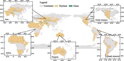
Figure 3 Map of global oasis distribution (2020)
Table
4 Statistics of global oasis areas and
number by continent
|
Continent
|
Oasis
area??km2??
|
Oasis
number
|
|
Asia
|
1,666,863.36
|
2,701
|
|
Africa
|
432,312.48
|
1,289
|
|
North America
|
233,638.00
|
654
|
|
Oceania
|
93,648.42
|
49
|
|
South America
|
55,731.01
|
157
|
3.3 Statistics of Global Oases by Country or Region
As
shown in Table 5, the top ten countries with the largest global oasis area
distribution are China, Pakistan, Iran, the United States, Kazakhstan, Iraq,
Uzbekistan, Australia, Saudi Arabia, and Egypt.
China has the largest
oasis area, covering 275,535.39 km2 with a total number of 1,398
oases. These oases are widely distributed, particularly in the arid regions of
the western provinces such as Xinjiang, Gansu, and Inner Mongolia. They serve
not only as critical resources for agricultural production
but also play vital roles in ecological protection and water resource
management.
This is followed by
Pakistan, which has an oasis area of 267,969.51 km2 and 67 oases.
The oases in Pakistan are primarily located in its western arid regions, such
as Balochistan Province. Although the number of oases
is significantly smaller than that of China, their total area remains
substantial.
Iran ranks third with an
oasis area of 239,371.98 km2 and 494 oases. Despite the relatively
high number of oases, they are dispersed across vast desert areas, making
efficient water resource utilization crucial for the country.
The United States has an
oasis area of 183,177.03 km2, with 512 oases mainly concentrated in
California and Nevada. Although the total oasis area is not as large as in the
aforementioned countries, the relatively high number and even distribution of
oases provide a solid foundation for water resource management and agricultural
irrigation in the U.S.
Kazakhstan possesses an
oasis area of 152,213.99 km2 with 24 oases, primarily located in the
arid zones of its western and southern regions. Although the number of oases is
not large, they are of great significance for local agriculture and ecological
protection, especially in remote areas where they serve as key sources of
sustenance.
Other countries, such as
Iraq (151,340.55 km2), Uzbekistan (111,055.10 km2), and
Australia (93,648.42 km2), also have substantial oasis areas but
relatively fewer oases. Their oases are mainly concentrated in specific
regions, resulting in relatively localized distributions.
The oases in Egypt
(82,453.44 km2) and Saudi Arabia (78,730.10 km2) also
play significant roles within their respective arid zones, particularly in
agricultural irrigation and water resource utilization.
Table
5 Statistics of global oasis areas and
number by country
|
Country
|
Oasis area (km2)
|
Number of oases
|
Country
|
Oasis area (km2)
|
Number of oases
|
|
China
|
275,535.39
|
1,398
|
Argentina
|
15,698.77
|
60
|
|
Pakistan
|
267,969.51
|
67
|
Bolivia
|
14,626.14
|
7
|
|
Iran
|
239,371.98
|
494
|
Chad
|
14,498.03
|
62
|
|
United States
|
183,177.03
|
512
|
Tajikistan
|
13,662.60
|
26
|
|
Kazakhstan
|
152,213.99
|
24
|
Oman
|
12,504.42
|
79
|
|
Iraq
|
151,340.55
|
1
|
Mauritania
|
10,855.64
|
68
|
|
Uzbekistan
|
111,055.10
|
19
|
Jordan
|
9,210.02
|
39
|
|
Australia
|
93,648.42
|
49
|
Niger
|
8,371.91
|
12
|
|
Egypt
|
82,453.44
|
168
|
Senegal
|
8,289.08
|
3
|
|
Saudi Arabia
|
78,730.10
|
264
|
Ethiopia
|
7,865.62
|
8
|
|
Syria
|
76,873.99
|
4
|
Kenya
|
7,829.66
|
12
|
|
Turkmenistan
|
65,661.65
|
27
|
Kuwait
|
5,639.11
|
21
|
|
Sudan
|
54,463.08
|
46
|
Qatar
|
5,584.19
|
1
|
|
Afghanistan
|
53,891.97
|
46
|
Israel
|
4,000.97
|
26
|
|
Mexico
|
50,460.97
|
142
|
Chile
|
3,548.53
|
41
|
|
Mali
|
49,979.07
|
24
|
Armenia
|
3,028.22
|
1
|
|
Turkey
|
48,815.65
|
11
|
Eritrea
|
2,228.50
|
14
|
|
Tunisia
|
46,506.30
|
77
|
Cameroon
|
2,035.32
|
1
|
|
Algeria
|
46,119.34
|
448
|
Somalia
|
1,689.99
|
15
|
|
Morocco
|
36,161.74
|
111
|
Lebanon
|
1,607.14
|
1
|
|
Libya
|
30,955.73
|
131
|
Azerbaijan
|
1,066.61
|
9
|
|
Kyrgyzstan
|
26,414.91
|
58
|
Angola
|
835.04
|
20
|
|
United Arab
Emirates
|
24,825.24
|
14
|
South Africa
|
676.01
|
8
|
|
Peru
|
21,857.57
|
49
|
Bahrain
|
570.99
|
1
|
|
Mongolia
|
19,937.56
|
23
|
Namibia
|
231.51
|
15
|
|
Nigeria
|
19,932.49
|
12
|
Djibouti
|
167.72
|
4
|
|
Yemen
|
17,351.50
|
47
|
Cape Verde
|
167.26
|
30
|
3.4 Top 10 Oases in the World
According
to the oasis coding system established in this study, Table 6 presents the top
ten largest oases in the world by area. The combined area of these top ten
oases is 1,062,883.77 km2, accounting for approximately 42.82% of
the global oasis area. In other words, less than 0.2% of individual oasis units
worldwide contain nearly half of the total oasis area, fully demonstrating the
??dominant effect?? of the oasis landscape. Among them, 2 oases, AS6A04001 and
ASPK05001 have a combined area of 548,876.35 km2, representing
22.12% of the global total, underscoring their immense significance.
In terms of continental
distribution, Asia and Africa hold absolute dominance: 6 of the top 10 largest
oases are located in Asia, with a total area of 846,390.19 km2,
while 4 are located in Africa, with a total area of 216,493.59 km2.
From a national or transnational perspective, the Central Asia-West Asia region
constitutes the core belt of global oases. For example, transnational oases
such as the six-country combination in West Asia (AS6A04001), the four-country
combination in Central Asia (4A), Central Asia plus Afghanistan (4B), and Egypt
and Libya (2P) all rank among the top ten. This indicates that the formation
and maintenance of oases in this region frequently transcend national
boundaries, reflecting not only their geographical connectivity but also the
inherent complexity of transnational water resource management in oasis
governance.
Table
6 Top 10 of the global oases
|
Oasis ID
|
Continent
|
Country
|
Basin
|
Area (km2)
|
|
AS6A04001
|
Asia
|
Iran & Iraq & Kuwait & Turkey &
Syria & Lebanon
|
04
|
300,023.58
|
|
ASPK05001
|
Asia
|
Pakistan
|
05
|
248,852.77
|
|
AS4A10001
|
Asia
|
Kazakhstan & Kyrgyzstan & Uzbekistan &
Tajikistan
|
10
|
127,200.28
|
|
AF2P27001
|
Africa
|
Egypt & Libya
|
27
|
75,328.00
|
|
AS4B10002
|
Asia
|
Uzbekistan & Tajikistan & Afghanistan &
Turkmenistan
|
10
|
71,848.91
|
|
ASCN12001
|
Asia
|
China
|
12
|
52,719.28
|
|
AFSD27002
|
Africa
|
Sudan
|
27
|
48,430.33
|
|
AF2U28001
|
Africa
|
Niger & Mali
|
28
|
47,756.96
|
|
ASKZ11001
|
Asia
|
Kazakhstan
|
11
|
45,745.37
|
|
AF2Q32001
|
Africa
|
Algeria & Tunisia
|
32
|
44,978.29
|
4 Discussion and Conclusion
This
study, based on Google Earth Pro imagery by employing manual visual
interpretation, successfully constructed the world??s first high-precision
global oasis dataset through the collective efforts of over 30 geographers over
a span of five-years. Although this dataset contains certain human-induced
errors and requires further refinement, it comprehensively depicts the spatial
distribution of global oases in 2020, marking a new phase in oasis research by
advancing from qualitative to quantitative analysis and providing novel
perspectives and methodologies for oasis science. All global oasis distribution
data are freely available for download and use, fully aligning with the ??Open
Science?? initiative proposed by UNESCO and representing a significant contribution
to the advancement of oasis science.
Nevertheless, although
these data are highly accurate, their acquisition has required considerable
time and human resource input. To achieve continuous updates and ensure the
long-term applicability of the data, the development of intelligent automated extraction
technologies for oasis boundaries is of critical importance. Reaching this goal
demands technological breakthroughs, and more importantly, broader
participation of scholars, particularly experts in artificial intelligence and
inter disciplinary collaborative research to improve both the efficiency and
practical value of oasis science.
Oasis cataloging fills a
long-standing gap in oasis science and represents a pioneering contribution to
the field. However, cataloging is not a static, one-time task but a dynamic,
systematic endeavor that requires sustained investment, regular updates, and
constant refinement. Once breakthroughs in intelligent boundary extraction are
achieved, real-time updates of global oases will become feasible, with changes
in oasis area and land use promptly reflected in the cataloging system.
Ideally, cataloging should be updated annually to ensure data timeliness and
accuracy; however, if costs are prohibitive, a comprehensive update at least
every five years should be guaranteed.
It should also be
emphasized that the attributes represented in oasis cataloging can be
continuously expanded and enriched. Each oasis corresponds to a unique code,
enabling the establishment of a dynamically updated attribute database. As
research advances, additional natural and socio-economic attributes such as
species counts, numbers of endangered species, population, GDP, educational
levels, and industrial structures can be incorporated. With the progressive
enrichment and refinement of this information, the future development of oases
will be supported by increasingly precise databases, allowing for more targeted
and feasible policy and management solutions. Given the escalating challenges
of climate change and the increasing conflicts between human activities and
natural resources, it is crucial to enhance the breadth, depth, and precision
of oasis cataloging. Additionally, establishing standardized, regulated
national- and regional-level oasis databases and information-sharing mechanisms
should be prioritized. True promotion of sustainable oasis development can only
be achieved by generating and sharing more comprehensive oasis data.
Author
Contributions
Gui, D. W. and Liu, C. were responsible for the
overall design of the paper framework; Lin, J. W. collected and processed the
data; Liu, Q. and Liu, Y. F. provided guidance
and made revisions to the paper; Abd-Elmabod, S. K. and Ahmed, Z. conducted data validation; Gui, D. W. and
Lin, J. W. wrote the paper.
Acknowledgments
Sincere
gratitude is extended to the Institutes of Science and Development, Chinese
Academy of Sciences, the Xinjiang Uygur Autonomous Region, and the National
Natural Science Foundation of China for their financial support of this
research. Furthermore, we extend our thanks to Dr. Shi, R. X. from the
Institute of Geographic Sciences and Natural Resources Research, Chinese
Academy of Sciences, for her valuable suggestions and meticulous corrections
during the global oasis data review process.
Conflicts
of Interest
The authors
declare no conflicts of interest.
References
[1]
Prvlie, R. Drylands extent and
environmental issues: a global approach [J]. Earth-Science Reviews, 2016??161: 259–278.
[2]
Chen, X., Luo, G. P. Research
and advances in the ecology of oases in arid areas [J]. Arid Land Geography,
2008, 31(4): 487–495.
[3]
Lin,
J. W., Gui, D. W., Liu, Y. F., et al. A high-precision oasis dataset for
China from remote sensing images [J]. Scientific
Data, 2024, 11(1): 726.
[4]
D??Odorico, P., Bhattachan, A., Davis, K. F., et al. Global
desertification: drivers and feedbacks [J]. Advances in Water Resources,
2013, 51: 326–344.
[5]
Liu, X., Wang, Y., Xin, L.
China??s oases have expanded by nearly 40% over the past 20 years [J]. Land
Degradation and Development, 2022, 33(18): 3817–3828.
[6]
Hern??ndez-Ag??ero, J. A., Falkenhahn, M., Hetzer, J., et al. Mapping the
global distribution and conservation status of oases-ecosystems of pivotal
biocultural relevance [J]. PeerJ, 2025, 13:
e18884.
[7]
Hailong, L., Peiji, S., Huali, T., et al. Characteristics and
driving forces of spatial expansion of oasis cities and towns in hexi corridor, Gansu Province, China [J]. Chinese
Geographical Science, 2015, 25(2): 250–262.
[8]
Qiao, X., Yang, G., Shi, J., et
al. Remote sensing data fusion to evaluate patterns of regional
evapotranspiration: a case study for dynamics of film-mulched drip-irrigated
cotton in China??s manas river basin over 20 years [J]. Remote Sensing,
2022, 14(14): 3438.
[9]
Allouche, F. K., Abidi, I., Delatre, E., et al. Assessing Tunisian Oasis Dynamics
Using Earth Observation and Landscape Metrics: Case of Djerid
and Nefzaoua Regions [M]//Allouche, F. K., Negm, A.
M. Environmental Remote Sensing and GIS in Tunisia. Cham: Springer Cham, 2021:
285–301.
[10]
Gao, H. J. The distribution and
types of oases in China [J]. Arid Land Geography, 1987, 10(4): 27–33.
[11]
Gui, D. W., Lin, J. W., Liu, Y.
F., et al. Oases distribution and catalog of China [J]. Journal of
Global Change Data & Discovery, 2025, 9(1): 1–13.
https://doi.org/10.3974/geodp.2025.01.01.
[12]
Luo, G. P., Zhou, C. H., Chen,
X. Preliminary analysis of the stability of oasis landscape at the scale of
arid regions [J]. Geography of Arid Areas, 2004, 27(4), 6.
[13]
Yan, D., Li, C., Zhang, X., et
al. A data set of global river networks and corresponding water resources
zones divisions v2 [J]. Scientific Data, 2022, 9(1): 770.
[14]
Notti, D., Cignetti, M.,
Godone, D., et al. Semi-automatic mapping of shallow landslides using
free sentinel-2 images and Google earth engine [J]. Natural Hazards and
Earth System Sciences, 2023, 23(7): 2625–2648.
[15]
Cheng, Y., Wang, W., Ren, Z., et
al. Multi-scale feature fusion and transformer network for urban green
space segmentation from high-resolution remote sensing images [J]. International
Journal of Applied Earth Observation and Geoinformation, 2023, 124: 103514.
[16]
Rostami, E., Sharifi, M. A., Hasanlou, M. Shoreline extraction using time series of
sentinel-2 satellite images by Google earth engine platform [J]. ISPRS
Annals of the Photogrammetry, Remote Sensing and Spatial Information
Sciences, 2023, X-4-W1-2022: 653–659.
[17]
Hafner, S., Ban, Y., Nascetti, A. Unsupervised domain adaptation for global
urban extraction using Sentinel-1 SAR and Sentinel-2 MSI data [J]. Remote
Sensing of Environment, 2022, 280: 113192.
[18]
Gui, D. W., Lin, J. W.,
Abd-Elmabod, S. K., et al. Egyptian Oasis [J/DB/OL]. Digital Journal
of Global Change Data Repository, 2025.
https://doi.org/10.3974/geodb.2025.02.10.V1.
[19]
Gui, D. W., Lin, J. W.,
Abd-Elmabod, S. K., et al. Ethiopian Oasis [J/DB/OL]. Digital Journal
of Global Change Data Repository, 2025.
https://doi.org/10.3974/geodb.2025.03.10.V1.
[20]
Gui, D. W., Lin, J. W.,
Abd-Elmabod, S. K., et al. Algerian Oasis [J/DB/OL]. Digital Journal
of Global Change Data Repository, 2025.
https://doi.org/10.3974/geodb.2025.04.07.V1.
[21]
Gui, D. W., Lin, J. W.,
Abd-Elmabod, S. K., et al. Angolan Oasis [J/DB/OL]. Digital Journal
of Global Change Data Repository, 2025.
https://doi.org/10.3974/geodb.2025.04.08.V1.
[22]
Gui, D. W., Lin, J. W., Dimian, R., et al. Libyan Oasis [J/DB/OL]. Digital
Journal of Global Change Data Repository, 2025.
https://doi.org/10.3974/geodb.2025.04.09.V1.
[23]
Gui, D. W., Lin, J. W., Dimian, R., et al. Malian Oasis [J/DB/OL]. Digital
Journal of Global Change Data Repository, 2025.
https://doi.org/10.3974/geodb.2025.04.10.V1.
[24]
Gui, D. W., Lin, J. W., Dimian, R., et al. Mauritanian Oasis [J/DB/OL]. Digital
Journal of Global Change Data Repository, 2025.
https://doi.org/10.3974/geodb.2025.04.11.V1.
[25]
Gui, D. W., Lin, J. W., Dimian, R., et al. Kenyan Oasis [J/DB/OL]. Digital
Journal of Global Change Data Repository, 2025.
https://doi.org/10.3974/geodb.2025.04.12.V1.
[26]
Gui, D. W., Lin, J. W., Dimian, R., et al. Namibian Oasis [J/DB/OL]. Digital
Journal of Global Change Data Repository, 2025.
https://doi.org/10.3974/geodb.2025.05.03.V1.
[27]
Gui, D. W., Lin, J. W., Dimian, R., et al. South African Oasis [J/DB/OL]. Digital
Journal of Global Change Data Repository, 2025.
https://doi.org/10.3974/geodb.2025.05.04.V1.
[28]
Gui, D. W., Lin, J. W., Dimian, R., et al. Sudanese Oasis [J/DB/OL]. Digital
Journal of Global Change Data Repository, 2025.
https://doi.org/10.3974/geodb.2025.05.06.V1.
[29]
Gui, D. W., Lin, J. W., Dimian, R., et al. Somali Oasis [J/DB/OL]. Digital
Journal of Global Change Data Repository, 2025.
https://doi.org/10.3974/geodb.2025.05.07.V1.
[30]
Gui, D. W., Lin, J. W., Dimian, R., et al. Tunisian Oasis [J/DB/OL]. Digital
Journal of Global Change Data Repository, 2025.
https://doi.org/10.3974/geodb.2025.06.02.V1.
[31]
Gui, D. W., Lin, J. W.,
Goethals, P., et al. Afghan Oasis [J/DB/OL]. Digital Journal of
Global Change Data Repository, 2025.
https://doi.org/10.3974/geodb.2025.06.03.V1.
[32]
Gui, D. W., Lin, J. W.,
Goethals, P., et al. Kyrgyzstani Oasis [J/DB/OL]. Digital Journal of
Global Change Data Repository, 2025.
https://doi.org/10.3974/geodb.2025.06.04.V1.
[33]
Gui, D. W., Lin, J. W.,
Abd-Elmabod, S. K., et al. Kuwaiti Oasis [J/DB/OL]. Digital Journal
of Global Change Data Repository, 2025.
https://doi.org/10.3974/geodb.2025.06.06.V1.
[34]
Gui, D. W., Lin, J. W.,
Abd-Elmabod, S. K., et al. Lebanese Oasis [J/DB/OL]. Digital Journal
of Global Change Data Repository, 2025.
https://doi.org/10.3974/geodb.2025.06.07.V1.
[35]
Gui, D. W., Lin, J. W.,
Abd-Elmabod, S. K., et al. Peruvian Oasis [J/DB/OL]. Digital Journal
of Global Change Data Repository, 2025.
https://doi.org/10.3974/geodb.2025.06.08.V1.
[36]
Gui, D. W., Lin, J. W.,
Abd-Elmabod, S. K., et al. Chilean Oasis [J/DB/OL]. Digital Journal
of Global Change Data Repository, 2025.
https://doi.org/10.3974/geodb.2025.06.09.V1.
[37]
Gui, D. W., Lin, J. W.,
Abd-Elmabod, S. K., et al. Argentine Oasis [J/DB/OL]. Digital Journal
of Global Change Data Repository, 2025.
https://doi.org/10.3974/geodb.2025.07.05.V1.
[38]
Gui, D. W., Lin, J. W.,
Martinez-Valderrama, J., et al. Australian Oasis [J/DB/OL]. Digital
Journal of Global Change Data Repository, 2025.
https://doi.org/10.3974/geodb.2025.07.06.V1.
[39]
Gui, D. W., Lin, J. W.,
Abd-Elmabod, S. K., et al. Bolivian Oasis [J/DB/OL]. Digital Journal
of Global Change Data Repository, 2025.
https://doi.org/10.3974/geodb.2025.07.07.V1.
[40]
Gui, D. W., Lin, J. W.,
Martinez-Valderrama, J., et al. Mexican Oasis [J/DB/OL]. Digital
Journal of Global Change Data Repository, 2025.
https://doi.org/10.3974/geodb.2025.07.08.V1.
[41]
Gui, D. W., Lin, J. W.,
Abd-Elmabod, S. K., et al.
Syrian Oasis [J/DB/OL]. Digital Journal of Global Change Data
Repository, 2025. https://doi.org/10.3974/geodb.2025.07.09.V1.
[42]
Gui, D. W., Lin, J. W.,
Abd-Elmabod, S. K., et al. Yemeni Oasis [J/DB/OL]. Digital Journal of
Global Change Data Repository, 2025.
https://doi.org/10.3974/geodb.2025.07.10.V1.
[43]
Gui, D. W., Lin, J. W.,
Abd-Elmabod, S. K., et al. Israeli Oasis [J/DB/OL]. Digital Journal
of Global Change Data Repository, 2025.
https://doi.org/10.3974/geodb.2025.07.11.V1.
[44]
Gui, D. W., Lin, J. W.,
Martinez-Valderrama, J., et al. Southwestern American Oasis [J/DB/OL]. Digital
Journal of Global Change Data Repository, 2025.
https://doi.org/10.3974/geodb.2025.07.12.V1.
[45]
Gui, D. W., Lin, J. W.,
Goethals, P., et al. United Arab Emirates Oasis [J/DB/OL]. Digital
Journal of Global Change Data Repository, 2025.
https://doi.org/10.3974/geodb.2025.07.13.V1.
[46]
Gui, D. W., Lin, J. W.,
Goethals, P., et al. Omani Oasis [J/DB/OL]. Digital Journal of Global
Change Data Repository, 2025. https://doi.org/10.3974/geodb.2025.07.14.V1.
[47]
Gui, D. W., Lin, J. W.,
Shareef, M., et al. Azerbaijani Oasis [J/DB/OL]. Digital Journal of
Global Change Data Repository, 2025.
https://doi.org/10.3974/geodb.2025.07.15.V1.
[48]
Gui, D. W., Lin, J. W.,
Shareef, M., et al. Pakistani Oasis [J/DB/OL]. Digital Journal of
Global Change Data Repository, 2025. https://doi.org/10.3974/geodb.2025.08.05.V1.
[49]
Gui, D. W., Lin, J. W.,
Shareef, M., et al. Bahraini Oasis [J/DB/OL]. Digital Journal of
Global Change Data Repository, 2025. https://doi.org/10.3974/geodb.2025.08.06.V1.
[50]
Gui, D. W., Lin, J. W.,
Abd-Elmabod, S. K., et al. Eritrean Oasis [J/DB/OL]. Digital Journal
of Global Change Data Repository, 2025.
https://doi.org/10.3974/geodb.2025.08.11.V1.
[51]
Gui, D. W., Lin, J. W.,
Abd-Elmabod, S. K., et al. Cape Verdean Oasis [J/DB/OL]. Digital
Journal of Global Change Data Repository, 2025.
https://doi.org/10.3974/geodb.2025.08.12.V1.
[52]
Gui, D. W., Lin, J. W., Dimian, R., et al. Djiboutian Oasis [J/DB/OL]. Digital
Journal of Global Change Data Repository, 2025.
https://doi.org/10.3974/geodb.2025.08.13.V1.
[53]
Gui, D. W., Lin, J. W.,
Goethals, P., et al. Kazakhstani Oasis [J/DB/OL]. Digital Journal of
Global Change Data Repository, 2025.
https://doi.org/10.3974/geodb.2025.08.14.V1.
[54]
Gui, D. W., Lin, J. W.,
Abd-Elmabod, S. K., et al. Qatari Oasis [J/DB/OL]. Digital Journal of
Global Change Data Repository, 2025.
https://doi.org/10.3974/geodb.2025.08.15.V1.
[55]
Gui, D. W., Lin, J. W.,
Abd-Elmabod, S. K., et al. Mongolian Oasis [J/DB/OL]. Digital Journal
of Global Change Data Repository, 2025.
https://doi.org/10.3974/geodb.2025.08.16.V1.
[56]
Gui, D. W., Lin, J. W.,
Abd-Elmabod, S. K., et al. Saudi Arabian Oasis [J/DB/OL]. Digital
Journal of Global Change Data Repository, 2025.
https://doi.org/10.3974/geodb.2025.08.17.V1.
[57]
Gui, D. W., Lin, J. W.,
Abd-Elmabod, S. K., et al. Turkish Oasis [J/DB/OL]. Digital Journal
of Global Change Data Repository, 2025.
https://doi.org/10.3974/geodb.2025.08.18.V1.
[58]
Gui, D. W., Lin, J. W.,
Abd-Elmabod, S. K., et al. Turkmen Oasis [J/DB/OL]. Digital Journal
of Global Change Data Repository, 2025.
https://doi.org/10.3974/geodb.2025.08.19.V1.
[59]
Gui, D. W., Lin, J. W.,
Abd-Elmabod, S. K., et al. Uzbek Oasis [J/DB/OL]. Digital Journal of
Global Change Data Repository, 2025.
https://doi.org/10.3974/geodb.2025.08.20.V1.
[60]
Gui, D. W., Lin, J. W.,
Abd-Elmabod, S. K., et al. Armenian Oasis [J/DB/OL]. Digital Journal
of Global Change Data Repository, 2025.
https://doi.org/10.3974/geodb.2025.08.21.V1.
[61]
Gui, D. W., Lin, J. W.,
Abd-Elmabod, S. K., et al. Iraqi Oasis [J/DB/OL]. Digital Journal of
Global Change Data Repository, 2025.
https://doi.org/10.3974/geodb.2025.08.22.V1.
[62]
Gui, D. W., Lin, J. W.,
Goethals, P., et al. Iranian Oasis [J/DB/OL]. Digital Journal of
Global Change Data Repository, 2025.
https://doi.org/10.3974/geodb.2025.09.03.V1.
[63]
Gui, D. W., Lin, J. W.,
Abd-Elmabod, S. K., et al. Jordanian Oasis [J/DB/OL]. Digital Journal
of Global Change Data Repository, 2025.
https://doi.org/10.3974/geodb.2025.08.04.V1.
[64]
Gui, D. W., Lin, J. W., Dimian, R., et al. Chadian Oasis [J/DB/OL]. Digital
Journal of Global Change Data Repository, 2025.
https://doi.org/10.3974/geodb.2025.08.05.V1.
[65]
Gui, D. W., Lin, J. W., Dimian, R., et al. Cameroonian Oasis [J/DB/OL]. Digital
Journal of Global Change Data Repository, 2025.
https://doi.org/10.3974/geodb.2025.08.06.V1.
[66]
Gui, D. W., Lin, J. W., Dimian, R., et al. Moroccan Oasis [J/DB/OL]. Digital
Journal of Global Change Data Repository, 2025.
https://doi.org/10.3974/geodb.2025.08.07.V1.
[67]
Gui, D. W., Lin, J. W., Dimian, R., et al. Nigerien Oasis [J/DB/OL].
Digital Journal of Global Change Data Repository, 2025.
https://doi.org/10.3974/geodb.2025.08.08.V1.
[68]
Gui, D. W., Lin, J. W., Dimian, R., et al. Nigerian Oasis [J/DB/OL]. Digital
Journal of Global Change Data Repository, 2025.
https://doi.org/10.3974/geodb.2025.08.09.V1.
[69]
Gui, D. W., Lin, J. W., Dimian, R., et al. Senegalese Oasis [J/DB/OL]. Digital
Journal of Global Change Data Repository, 2025.
https://doi.org/10.3974/geodb.2025.08.10.V1.
[70]
Gui, D. W., Lin, J. W.,
Abd-Elmabod, S. K., et al. Tajik Oasis [J/DB/OL]. Digital Journal of
Global Change Data Repository, 2025.
https://doi.org/10.3974/geodb.2025.08.11.V1.
[71]
Gui, D. W., Lin, J. W., Liu, C.
Chinese Oasis [J/DB/OL]. Digital Journal of Global Change Data Repository,
2025. https://doi.org/10.3974/geodb.2025.08.12.V1.