Global Change Data Encyclopedia
Shiant Isles, United Kingdom
Liu, C.* Shi, R. X.
Institute of Geographic Sciences and Natural Resources Research, Chinese Academy of Sciences, Beijing 100101, China
Keywords: Shiant Isles; United Kingdom; Scotland; Garbh Eilean; data encyclopedia
|
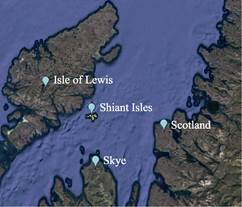
Figure 1 Geo-location of Shiant Isles
(.kmz format)
|
The Shiant Isles of Scotland is located from 57°52′45″N to 57°54′30″N, 6°25′3″W to 6°19′21″W[1–2]. It is in the Minch Strait and belongs to Outer Hebrides[3], separated 5.34 km from Lewis Island[4] at its northwest, 32 km from the Scotland at its east, and 19 km from Skye at its south (Figures 1-2). The Shiant Isles are private[2].
|
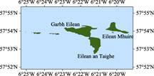
Figure 2 Geo-location of Shiant Isles
(.shp format)
|
The Shiant Isles consist of 3 main islands, and 18 small isles and rocks. The main islands are Garbh Eilean[5], Eilean an Taighe[6], and Eilean Mhuire[7]. The small islands and rocks includes Galca Mor, Galta Beag, Sgeir Mhic a’Ghobha, Sgeir Mianais, Bodach, Sgeir na Ruideag, Stacan Laidir, and Damhag, etc.[8–9] (Table 1). The total area of the Shiant Isles is 2.15 km2 and the coastline is 17.98 km. In the Shiant Isles, Garbh Eilean is the biggest isle with an area of 0.98 km2, Eilean an Taighe is the second biggest one with an area of 0.66 km2, and Eilean Mhuire is the third one with an area of 0.42 km2. The dataset was developed based on the ArcGIS platform[10], Google Earth images and the map of Scotland[9]. The dataset is archived in both .kmz and .shp formats, consisting of 14 data files with the data size of 217 KB (Compressed to 96.2 KB in two data files).
Table 1 Geo-location, area and coastline of each isles in the Shiant Isles[1]
|
Name of island
|
Geo-location
|
Central location
|
Area (m2)
|
Coastline (m)
|
|
Garbh Eilean
|
57º53′39″N-57º54′19″N, 6º22′54″W-6º21′5″W
|
57º54′1″N,
6º21′57″W
|
978,050
|
5,830
|
|
Eilean an Taighe
|
57º52′47″N-57º53′40″N, 6º21′35″W-6º20′53″W
|
57º53′18″N,
6º21′11″W
|
660,825
|
4,073
|
|
Eilean Mhuire
|
57º53′52″N-57º54′30″N, 6º20′36″W-6º19′26″W
|
57º54′9″N,
6º20′6″W
|
418,352
|
3,829
|
|
Galca Mor
|
57º53′51″N-57º53′56″N, 6º24′28″W-6º24′12″W
|
57º53′53″N,
6º24′21″W
|
27,947
|
668
|
|
Galta Beag
|
57º53′48″N-57º53′53″N, 6º23′21″W-6º23′12″W
|
57º53′51″N,
6º23′16″W
|
15,151
|
497
|
|
Sgeir Mhic a’ Ghobha
|
57º53′52″N-57º53′56″N, 6º24′36″W-6º24′28″W
|
57º53′54″N,
6º24′32″W
|
11,937
|
422
|
|
Sgeir Mianais
|
57º52′45″N-57º52′48″N, 6º21′16″W-6º21′11″W
|
57º52′46″N,
6º21′14″W
|
7,556
|
331
|
|
Bodach
|
57º53′50″N-57º53′53″N, 6º23′34″W-6º23′29″W
|
57º53′51″N,
6º23′31″W
|
5,253
|
299
|
|
Sgeir na Ruideag
|
57º53′54″N-57º53′57″N, 6º20′16″W-6º20′10″W
|
57º53′55″N,
6º20′13″W
|
5,131
|
294
|
|
Stacan Laidir
|
57º53′51″N-57º53′53″N, 6º23′41″W-6º23′38″W
|
57º53′52″N,
6º23′40″W
|
1,873
|
169
|
|
Damhag
|
57º53′57″N-57º53′58″N, 6º25′3″W-6º25′1″W
|
57º53′58″N,
6º25′2″W
|
339
|
69
|
|
Others
|
|
|
18,066
|
1,496
|
|
Shiant Isles
|
|
|
2,150,480
|
17,976
|
References
[1] Liu, C., Shi, R. X. Shiant Isles [DB/OL]. Global Change Research Data Publishing & Repository, 2017. DOI: 10.3974/geodb.2017.01.04.V1.
[2] Shiant_Isles [OL]. https://en.wikipedia.org/wiki/Shiat_Isles.
[3] Outer Hebrides [OL]. https://en.wikipedia.org/wiki/Outer_Hebrides.
[4] Isle of Lewis [OL]. https://en.wikipedia.org/wiki/Isle_of_Lewis.
[5] Garbh Eilean [OL]. https://en.wikipedia.org/wiki/Garbh_Eilean.
[6] Eilean an Taighe [OL]. https://en.wikipedia.org/wiki/Eilean_an_Taighe.
[7] Eilean Mhuire [OL]. https://en.wikipedia.org/wiki/Eilean_Mhuire.
[8] Editorial Group of Handbook of Global Geographical Names. Handbook of Global Geographical Names [M]. Beijing: SinoMaps Press, 1999.
[9] SinoMaps Press. World Series Atlas: British Atlas [M]. Beijing: SinoMaps Press, 2007.
Data Computing Environment
[10] ESRI. ArcGIS campus license of the Institute of Geographic Science and Natural Resources Research, Chinese Academy of Sciences.
URL for Data Downloading
http://www.geodoi.ac.cn/WebEn/doi.aspx?Id=640.
Or search though: http://www.geodoi.ac.cn.