Temporal-spatial Cultivated Land and Conversion from Dry Farmland to Paddy Dataset in the Western Jilin Province, China(1990–2015)
Ren, Y. X.1,2 Li, X. Y.1* Wang, Z. M.2 Yang, L. M.1
1. College of Earth Sciences, Jilin University, Changchun 130061, China;
2. Key Laboratory of Wetland Ecology and Environment, Northeast Institute of Geography and Agroecology, Chinese Academy of Sciences, Changchun 130012, China
Abstract: Based on Landsat TM/ETM/OLI image data of the 4 annual periods of 1990, 2000, 2010, and 2015, the characteristics and change in areas of cultivated land and conversion from dry farmland to paddy fields in western Jilin province were analyzed. The dataset included 4 sets of spatial data and 3 sets of tabular data. Spatial data include: (1) study area boundary data; (2) spatial distribution data of cultivated land in 1990, 2000, 2010, and 2015; (3) spatial change data of cultivated land in 1990–2000, 2000–2010, and 2010–2015; (4) Spatial conversion data between dry farmland and paddy fields within cultivated land in 1990–2000, 2000–2010, and 2010–2015. The tabular data include: (1) statistical data on cultivated land area and its change during the 4 periods from 1990 to 2015; (2) conversion contribution rate between dry farmland and other land cover types in 1990–2000, 2000–2010, and 2010–2015; (3) conversion contribution rate data between paddy fields in western Jilin province and other land cover types in 1990–2000, 2000-2010, and 2010–2015. The dataset is stored in .tif, .shp, and .xlsx formats and consists of 70 files with a data volume of 40.8 MB (compressed to 1 file, 14.9 MB). The research results based on this dataset are published in Remote Sensing Technology and Applications, Vol. 34, No. 4, 2019.
Keywords: cultivated land; dry farmland; paddy field; western Jilin province; Remote Sensing Technology and Applications
1 Introduction
Cultivated land resources are important as they guarantee national food security[1–2]. In recent years in China, the increase in population, economic development, industrialization, and urbanization have led to a reduction in cultivated land resources in traditional agricultural areas across the country; this has seriously threatened food production and national food security[3]. With the acceleration of urbanization, constraints such as land and water resources and climate change have stalled the continued increase in food production. Western Jilin province is an important grain-producing area of China. In recent years, land development and consolidation projects have been implemented, and food production conditions have been improved. Through land consolidation, the internal structure of cultivated land has undergone drastic changes, which has transformed large areas of dry farmland into paddy fields[4]. These changes have had an important impact on regional land resources and water resources. Systematic monitoring of the long-term sequence of the temporal and spatial characteristics of cultivated land in western Jilin province, especially the transformation of dry farmland to paddy fields, has important scientific significance. It plays a guiding role in the rational use of natural resources, regional agricultural sustainable development, and national food security [5]. This dataset used Landsat TM/ETM/OLI and other multi-source remote sensing image data to study the changes in cultivated land in western Jilin province. The resulting dataset of the temporal and spatial characteristics of cultivated land change and conversions from dry farmland to paddy fields can provide a reference for the rational layout and land planning of regional grain production.
2 Metadata of Dataset
The metadata of the “Temporal-spatial cultivated land and conversion from dry farmland to paddy dataset in the western Jilin province, China (1990–2015)”[6] is summarized in Table 1, including full name, short name, authors, year of the dataset, temporal resolution, spatial resolution, data format, data size, data files, data publisher, and data sharing policy, etc.
Table 1 Metadata summary of the “Temporal-spatial cultivated land and conversion from dry farmland to paddy dataset in the western Jilin province, China (1990–2015)”
|
Items
|
Description
|
|
Dataset full name
|
Temporal-spatial cultivated land and conversion from dry farmland to paddy dataset in the western Jilin province, China (1990–2015)
|
|
Dataset short name
|
Culti.LandChangewJilin_1990-2015
|
|
Authors
|
Ren, Y. X. S-9821-2019, Jilin University, 15271915264@163.com
Li, X. Y. T-3625-2019, Jilin University, lxyan@jlu.edu.cn.
Wang, Z. M. T-4507-2019 Northeast Institute of Geography and Agricultural Ecology, Chinese Academy of Sciences, zongmingwang@iga.ac.cn
Yang, L. M. T-3389-2019, Jilin University, aurora_ylm@sina.com
|
|
Geographical region
|
The western Jilin province
|
|
Year
|
1990, 2000, 2010, 2015
|
|
Data format
|
.tif, .shp, .xlsx
|
|
Data size
|
14.9 MB (after compression)
|
|
Data files
|
(1) Spatial data includes: study area boundary data; spatial distribution data of cultivated land in 1990, 2000, 2010, and 2015; spatial change data of cultivated land in 1990–2000, 2000–2010 and 2010–2015; 1990–2000, 2000–2010, and 2010–2015; spatial transformation data between dry farmland and paddy fields within the annual cultivated land
(2) The tabular data includes: statistics on the area of cultivated land and its change during the four periods from 1990 to 2015; data on the conversion contribution rate between dry farmland and other land cover types in 1990–2000, 2000–2010, and 2010–2015; conversion contribution rate data between paddy fields in western Jilin province and other land cover types in 1990–2000, 2000–2010, and 2010–2015
|
|
Foundations
|
Chinese Academy of Sciences (KFJ-SW-YW026, KFJ-STS-ZDTP-009)
|
|
Data publisher
|
Global Change Research Data Publishing & Repository, http://www.geodoi.ac.cn
|
|
Address
|
No. 11A, Datun Road, Chaoyang District, Beijing 100101, China
|
|
Data sharing policy
|
Data from the Global Change Research Data Publishing & Repository includes metadata, datasets (data products), and publications (in this case, in the Journal of Global Change Data & Discovery). Data sharing policy includes: (1) Data are openly available and can be free downloaded via the Internet; (2) End users are encouraged to use Data subject to citation; (3) Users, who are by definition also value-added service providers, are welcome to redistribute Data subject to written permission from the GCdataPR Editorial Office and the issuance of a Data redistribution license; and (4) If Data are used to compile new datasets, the ‘ten percent principal’ should be followed such that Data records utilized should not surpass 10% of the new dataset contents, while sources should be clearly noted in suitable places in the new dataset [7]
|
3 Methods
This study used a total of 40 scenes of Landsat TM/ETM/OLI images from 1990, 2000, 2010, and 2015 as the main data source. The images used were from the US Geological Survey (USGS) (https://www.usgs.gov). The selected image period was from July to October. The image was cloudless or partly cloudy (cloud coverage <10%). The image was subjected to pre-processing, such as atmospheric correction and geometric correction, and errors were controlled to within one pixel. Reference was made to the “China Land Cover Classification System Based on Carbon Budget”[8] and the “National Ecosystem Classification System Based on Remote Sensing Technology”[9], combined with the land cover characteristics of the study area, to determine the land cover classification system, including cultivated land, forest land, grassland, wetland, artificial surface, and bare land, of which cultivated land included two secondary types of paddy fields and dry farmland. e Cognition software was used as the remote sensing image classification platform. The object-oriented and decision tree were combined to classify the remote sensing images, and spatial distribution data of land cover in different periods were obtained.
4 Results and Validation
4.1 Dataset Composition
The metadata of the “Temporal-spatial cultivated land and conversion from dry farmland to paddy dataset in the western Jilin province, China (1990–2015)” included 4 sets of spatial data and 3 sets of tabular data, as follows. Spatial data included: study area boundary data; spatial distribution data of cultivated land in 1990, 2000, 2010, and 2015; spatial change data of cultivated land in 1990–2000, 2000–2010, and 2010–2015; 1990–2000, 2000–2010 and 2010–2015 spatial conversion data between dry farmland and paddy fields within the annual cultivated land. The tabular data included: statistics on cultivated land area and its change during the 4 periods from 1990 to 2015; conversion contribution rate data between dry farmland and other land cover types from 1990 to 2000, 2000–2010, and 2010 to 2015; conversion contribution rate data between paddy fields in western Jilin province and other land cover types in 1990–2000, 2000–2010, and 2010–2015.
4.2 Data Results
In order to introduce the characteristics of cultivated land change in western Jilin province, this paper selected the cultivated land data from 1990, 2000, 2010, and 2015 for a brief analysis. The spatial distribution and quantitative change of cultivated land in western Jilin province from 1990 to 2015 are shown in Figure 1 and Table 2[10]. It can be seen that the area of cultivated land in western Jilin province increased year by year in 1990, 2000, 2010, and 2015. Cultivated land is the main land use pattern in western Jilin province. In 2015, the cultivated land area accounted for more than 60% of the total land area; of this, dry farmland accounted for about 89% and it was widely distributed throughout the study area. Meanwhile, paddy fields accounted for about 11% of the cultivated land area, and were concentrated in the northern part of the study area due to the influence of water supply.
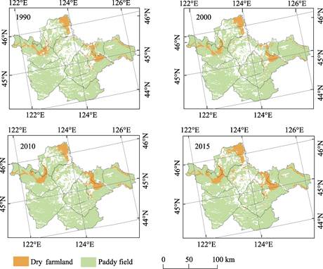
Figure 1 The spatial distribution change of cultivated land in western Jilin province from 1990 to 2015
Table 2 The quantitative change of cultivated land in western Jilin province from 1990 to 2015
|
Class
|
Area (km2)
|
Area of change (km2)/Speed of change (km2/a)
|
|
1990
|
2000
|
2010
|
2015
|
1990–2000
|
2000–2010
|
2010–2015
|
|
Cultivated land
|
28,191.48
|
29,493.40
|
30,245.99
|
30,350.81
|
1,301.92/130.19
|
754.73/75.47
|
104.82/20.96
|
|
Dry farmland
|
25,988.03
|
26,910.53
|
27,387.43
|
27,007.97
|
922.51/92.25
|
479.05/47.91
|
–379.46/–75.84
|
|
Paddy field
|
2,203.46
|
2,582.87
|
2,858.56
|
3,342.85
|
379.41/37.94
|
275.69/27.57
|
484.29/96.86
|
During the period from 1990 to 2015, the changes in cultivated land in western Jilin province had obvious spatial and temporal heterogeneity, and there was a continuous increase. From 1990 to 2000, cultivated land increased by 1,301.92 km2, with a rate of increase of 130.19 km2/a. The increased area was mainly concentrated in the western and central eastern part of the study area. From 2000 to 2010, the rate of increase slowed down from 754.73 km2 to 75.47 km2/a. The rate of increase of cultivated land in 2010–2015 was further slowed down, with a net increase of 104.82 km2, and a rate of increase of 20.96 km2/a. During the period 1990–2015, the area of paddy fields in western Jilin province increased by 51.71%, and the growth rate reached 45.58 km2/a (Table 2). Among the net increase in paddy field area, the proportion from dry farmland gradually increased, with the trend of conversions from dry farmland to paddy field also gradually increasing.
5 Discussion and Conclusion
Based on Landsat TM/ETM/OLI image data from 1990, 2000, 2010, and 2015, this dataset analyzed cultivated land conversions from dry farmland to paddy fields in western Jilin province. It can be seen from the results that the total cultivated land in western Jilin province increased during the period from 1990 to 2015, but that the increasing trend gradually slowed down. The area of dry farmland initially increased and then decreased; furthermore, paddy fields accounted for a relatively low proportion of the cultivated land. However, in recent years, the area of paddy fields has increased significantly. The trend of conversions from dry farmland to paddy field gradually increased. It provides a data base and scientific basis for the rational distribution of regional grain production and future plans for increasing national grain production.
Author Contributions
Li, X. Y. designed the dataset algorithms and contributed to data processing and analysis. Wang, Z. M. and Yang, L. M. performed data validation. Ren, Y. X. wrote the data paper.
References
[1] Turner II, B. L., Lambin, E. F., Reenberg, A. The emergence of land change science for global environmental change and sustainability [J]. Proceedings of the National Academy of Sciences of the United States of America, 2007, 104(52): 20666–20671.
[2] Fu, Z. Q., Cai, Y. L., Yang, Y. X., et al. Research on the relationship of cultivated land change and food security in China [J]. Journal of Natural Resources, 2016, 16(4): 313–318.
[3] Liu, L., Xu, X. L., Liu, J. Y., et al. Impact of farmland changes on production potential in China during recent two decades [J]. Acta Geographica Sintca, 2014, 69(12): 1767–1778.
[4] Nie, Y. Land Development and consolidation of Jilin province in the western region area fffect and comprehensive benefit evaluation [D]. Changchun: Jilin Agricultural University, 2015.
[5] Man, W. D., Wang, Z. M., Liu, M. Y., et al. Spatio-temporal dynamics analysis of cropland in Northeast China during 1990-2013 based on remote sensing [J]. Transactions of the Chinese Society of Agricultural Engineering, 2016, 32(7): 1–10.
[6] Ren, Y. X., Li, X. Y., Wang, Z. M., et al. Temporal-spatial cultivated land and conversion from dry farmland to paddy dataset in the western Jilin province, China (1990–2015) [DB/OL]. Global Change Research Data Publishing & Repository, 2019. DOI: 10.3974/geodb.2019.04.09.V1.
[7] GCdataPR Editorial Office. GCdataPR data sharing policy [OL]. DOI: 10.3974/dp.policy.2014.05 (Updated 2017).
[8] Zhang, L., Wu, B. F., Li, X. S., et al. Classification system of China land cover for carbon budget [J]. Acta Ecologica Sinica, 2014, 34(24): 7158–7166.
[9] Ouyang, Z. Y., Zhang, L., Wu, B. F., et al. An ecosystem classification system based on remote sensor information in China [J]. Acta Ecologica Sinica, 2015, 35(2): 219–226.
[10] Ren, Y. X., Li, X. Y., Wang, Z. M., et al. Changes of croplands and conversions from dry farmland to paddy field in Western Jilin province during 1990–2015. Remote Sensing Technology and Application (In press).