Global Change Data Encyclopedia
Izu Islands, Japan
Liu, C.1* Chen, W. B.2,3 Shi, R. X.1
1. Institute of Geographic Sciences and Natural Resources Research, Chinese Academy of Sciences, Beijing 100101, China;
2. Keio Research Institute at SFC, Keio University, Fujisawa 2520882, Japan;
3. Nature & Science Consulting Co. Ltd., Yokohama 2310032, Japan
Keywords: Izu Islands; volcano; Japan; Pacific Ocean; data encyclopedia
|
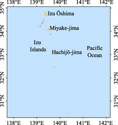
Figure 1 Geo-location of Izu Islands
|
The Izu Islands are located in the Philippine Sea of the western Pacific Ocean. It extends 562 km from south to north, 26 km to the Izu Peninsula in its northwest and 351 km to the Muko-jima in the Ogasawara Archipelago in its south. The geolocation of the Izu Islands is from 29°47′38″N to 34°47′57″N, from 138°48′55″E to 140°20′32″E (Figure 1)[1].
The Izu Islands are a group of old and new volcanoes islands in the Fuji volcanic belt, which forms the Izu-Bonin-Mariana Arc with the Ogasawara Archipelago and the Mariana Islands in the North Pacific Ocean. Most of the islands are made up of one volcano, and there are also some islands made up of several volcanoes. For example, Hachijō-jima is an island composed of two volcanoes: Higashi-yama, also called Mihara-yama, and Nishi-yama, also called Hachijō-fuji. The highest peak of the Izu Islands is the summit of the Mt. Nishi-yama located in the Hachijō-jima (854 m above sea level, Figure 2). The Izu Islands are a special region with frequent natural disasters, such as volcanoes, earthquakes, tsunamis, typhoons, etc. The Izu Islands are governed by the Tokyo administrative jurisdiction (Tokyo Metropolitan Department), Japan[2–3].
Izu Islands are consisted of Izu seven islands, including Izu Ōshima, To-shima, Nii-jima, Kōzu-shima, Miyake-jima, Mikura-jima, Hachijō-jima, and a series of small islands[4–19]. Among them, five islands, including Izu Ōshima, Nii-jima, Kōzu-shima, Miyazaki Island and Hachijō-jima, have airports, which can be accessed by airplanes[20].
|
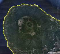
Figure 2 The volcano image in the Nishi-yama, Hachijō-jima (Google Earth Image)
|
The total area of the Izu Islands is 301.25 km2, and the coastline is 340.81 km long. In the Izu Islands, the largest island is the Izu Ōshima, usually called Ōshima, with the area of 90.98 km2 and the coastline of 60.42 km. The geo-location, area and coastline of each island in the Izu Islands are shown in Table 1.
The dataset is developed based on Google Earth image[21] integrated with the information from the maps and references[3–4]. The dataset is archived in both .kmz[21] and .shp[22] data formats, and it is consisted of 15 data files with data size of 2.95 MB (compressed in 2 data files, 1.12 MB)[1].
Table 1 List of Main Islands in the Izu Islands, Japan
|
Name of island [4]
|
Geo-location
|
Central point
|
Area (km2)
|
Coastline (km)
|
|
Izu Ōshima[5]
|
34º40′40″N-34º47′57″N,
139º20′55″E-139º26′60″E
|
34º44′15″N, 139º23′56″E
|
91.00
|
60.42
|
|
Hachijō-jima[6]
|
33º2′43″N-33º9′35″N,
139º44′18″E-139º51′34″E
|
33º6′23″N, 139º47′52″E
|
69.12
|
57.77
|
|
Miyake-jima[7]
|
34º2′41″N-34º7′32″N,
139º28′22″E-139º34′11″E
|
34º5′6″N, 139º31′16″E
|
55.43
|
41.86
|
|
Nii-jima[8]
|
34º19′52″N-34º25′53″N,
139º14′22″E-139º17′35″E
|
34º22′37″N, 139º16′0″E
|
23.18
|
41.26
|
|
Mikura-jima[9]
|
33º51′7″N-33º54′4″N,
139º34′35″E-139º37′55″E
|
33º52′30″N, 139º36′12″E
|
20.52
|
19.19
|
|
Kōzu-shima[10]
|
34º11′4″N-34º14′46″N,
139º7′9″E-139º10′41″E
|
34º12′53″N, 139º8′52″E
|
18.88
|
36.23
|
|
Aogashima[11]
|
32º26′34″N-32º28′25″N,
139º45′15″E-139º46′53″E
|
32º27′26″N, 139º45′59″E
|
6.04
|
9.76
|
|
Tori-shima[12]
|
30º28′23″N-30º29′45″N,
140º17′10″E-140º18′51″E
|
30º29′4″N, 140º18′4″E
|
4.76
|
8.71
|
|
To-shima[13]
|
34º30′39″N-34º32′7″N,
139º16′2″E-139º17′34″E
|
34º31′21″N, 139º16′45″E
|
4.06
|
10.45
|
|
Shikine-jima[14]
|
34º18′54″N-34º20′18″N,
139º11′38″E-139º13′41″E
|
34º19′32″N, 139º12′41″E
|
4.06
|
20.98
|
|
Hachijō-kojima[15]
|
33º6′56″N-33º8′12″N,
139º40′32″E-139º42′5″E
|
33º7′33″N, 139º41′17″E
|
3.05
|
10.57
|
|
Udone-shima[16]
|
34º28′10″N-34º28′35″N,
139º17′18″E-139º17′58″E
|
34º28′21″N, 139º17′39″E
|
0.40
|
5.26
|
|
Jinai-tō
|
34º21′56″N-34º22′33″N,
139º13′21″E-139º13′48″E
|
34º22′28″N, 139º13′28″E
|
0.26
|
4.79
|
|
Haya Island
|
34º19′27″N-34º19′39″N,
139º16′31″E-139º16′51″E
|
34º19′33″N, 139º16′40″E
|
0.12
|
1.48
|
|
Onbase Island
|
34º10′59″N-34º11′17″N,
139º4′18″E-139º4′42″E
|
34º11′12″N, 139º4′36″E
|
0.09
|
2.26
|
|
Tadanae Island
|
34º12′21″N-34º12′33″N,
139º11′22″E-139º11′35″E
|
34º12′28″N, 139º11′30″E
|
0.12
|
3.36
|
|
Zenisu
|
33º56′33″N–33º56′40″N,
138º49′0″E-138º49′6″E
|
33º56′37″N, 138º49′3″E
|
0.03
|
1.45
|
|
Inamba-jima
|
33º39′4″N–33º39′8″N,
139º17′54″E-139º17′58″E
|
33º39′6″N, 139º17′56″E
|
0.01
|
0.43
|
|
Onohara Islands[17]
|
34º2′52″N-34º2′58″N,
139º22′53″E-139º23′6″E
|
34º2′55″N, 139º23′1″E
|
0.07
|
2.68
|
|
Sumisu-tō
|
31º26′15″N-31º26′25″N,
140º2′59″E-140º3′5″E
|
31º26′20″N, 140º3′2″E
|
0.03
|
0.79
|
|
Myōjin-shō[18]
|
31º53′12″N–31º53′19″N,
139º55′1″E–139º55′7″E
|
31º53′15″N, 139º55′4″E
|
0.01
|
0.89
|
References
[1] Liu, C., Chen, W. B., Shi, R. X. Izu Islands [DB/OL]. Global Change Research Data Publishing & Repository, 2016. DOI: 10.3974/geodb.2016.09.11.V1.
[2] Izu Islands [OL]. https://en.wikipedia.org/wiki/Izu_Islands.
[3] Tokyo Outlying Areas. The World Book Encyclopedia (Volume 19) [M]. Field Enterprises Educational Cooperation, USA, 1976.
[4] Editorial Officeof Global Geographical Names. Chinese-Foreign Language Handbook of Global Geographical Names [M]. Beijing: SinoMaps Press, 1999.
[5] Izu Ōshima [OL]. https://en.wikipedia.org/wiki/Izu_%C5%8Cshima.
[6] Hachijō-jima [OL]. https://en.wikipedia.org/wiki/Hachij%C5%8D-jima.
[7] Miyake-jima [OL]. https://en.wikipedia.org/wiki/Miyake-jima.
[8] Nii-jima [OL]. https://en.wikipedia.org/wiki/Nii-jima.
[9] Mikura-jima [OL]. https://en.wikipedia.org/wiki/Mikura-jima.
[10] Kōzu-shima [OL]. https://en.wikipedia.org/wiki/K%C5%8Dzu-shima.
[11] Aogashima [OL]. https://en.wikipedia.org/wiki/Aogashima.
[12] Tori-shima [OL]. https://en.wikipedia.org/wiki/Tori-shima_(Izu_Islands).
[13] To-shima, Tokyo [OL]. https://en.wikipedia.org/wiki/To-shima,_Tokyo.
[14] Shikine-jima [OL]. https://en.wikipedia.org/wiki/Shikine-jima.
[15] Hachijō-kojima [OL]. https://en.wikipedia.org/wiki/Hachij%C5%8D-kojima.
[16] Udone-shima [OL]. https://en.wikipedia.org/wiki/Udone-shima.
[17] Ōnohara Islands [OL]. https://en.wikipedia.org/wiki/%C5%8Cnohara_Islands.
[18] Bayonnaise Rocks [OL]. https://en.wikipedia.org/wiki/Bayonnaise_Rocks.
[19] Lot’s Wife (crag) [OL]. https://en.wikipedia.org/wiki/Lot%27s_Wife_(crag).
[20] David Megginson. OurAirports [OL]. https://openflights.org/data.html.
Data Computing Environment
[21] Google LLC. Google Earth Pro. 7.3.2.5481 (32-bit), hk.google.com.
[22] ESRI. ArcGIS campus license of Institute of Geographic Sciences and Natural Resources Research, Chinese Academy of Sciences.
URL for Data Downloading
http://www.geodoi.ac.cn/WebEn/doi.aspx?ID=621.
Or search through: http://www.geodoi.ac.cn.