Dataset of Classification and Land Use of the Ecological Core Areas of China
Xu, E. Q.* Zhang, H. Q.
Key Laboratory of Land Surface Pattern and Simulation, Institute of Geographic Sciences and Natural Resources Research, Chinese Academy of Sciences, Beijing 100101, China
Abstract: Rapid social and economic development has led to a range of serious ecological and environmental problems in China. The development of a classification and land use dataset that encompasses ecological core areas nationally is therefore important to support decision making and provide a scientific basis for ecological restoration and environmental protection. The dataset presented here includes: (1) 1??1,000,000 scale data of ecological core areas encompassing water conservation area, soil conservation areas, as well as wind-breaking and sand-fixing area, flood regulation area, and riparian protection area and biodiversity conservation areas; (2) 1 km scale grid data on land use within these areas in 2008; and (3) statistical data on land use changes between the 1980s and 2008. These data files encompass the spatial scope of ecological core areas within China, and delineate red lines for maintaining national ecological security. Dataset is archived in .shp, .tif, and .xslx formats with the data size of 7.14 MB in compress.
Keywords: ecological core areas; protection; land use; China
1 Introduction
Rapid economic development had led to environmental problems in China[1]. The central government issued a series of policies to solve these problems. including the management of the “Eco-geographical Zoning in China”[2], “Ecological Function Zoning in China”[3], and “Major Function Oriented Zoning in China”[4]. Building on related ecological engineering and restoration planning, a classification and land use dataset of ecological core areas within China[5] was therefore generated. The Dataset of Classification and Land Use of the
Ecological Core Areas of China was developed for this study for evaluating both the status and dynamic changes in land use within ecological core areas nationally between the late 1980s and 2008.
2 Metadata of Dataset
The metadata of dataset of classification and land use of the ecological core areas of China dataset are summarized in Table 1.
Table 1 Metadata summary of the dataset of classification and land use of the ecological core areas of China
|
Items
|
Description
|
|
Dataset full name
|
Dataset of classification and land use of the ecological core areas of China
|
|
Dataset short name
|
Classification_LandUse_EcologicalCoreArea_China
|
|
Authors
|
Xu, E. Q. U-9329-2017, Institute of Geographic Sciences and Natural Resources Research, Chinese Academy of Sciences, xueq@igsnrr.ac.cn
Zhang, H. Q. U-9331-2017, Institute of Geographic Sciences and Natural Resources Research, Chinese Academy of Sciences, zhanghq@igsnrr.ac.cn
|
|
Geographical region
|
China
|
|
Temporal resolution
|
Ecological core areas of China (2015), Land use datasets (1980s, 2008)
|
|
Spatial resolution
|
1 km ×1 km, 1: 1,000,000
|
|
Data format
|
.shp, .tif, .xslx
|
|
|
|
Data size
|
7.14 MB (in compress)
|
|
|
|
Data files
|
1. Spatial distribution of ecological core areas within China, composed of .shp files
2. Land use maps of ecological core areas within China (1980s, 2008), composed of .tif files
3. Statistical data on land use change between the 1980s and 2008, composed of .xslx files
|
|
Foundation(s)
|
National Natural Science Foundation of China (41601095, 41671097)
|
|
Data publisher
|
Global Change Research Data Publishing & Repository, http://www.geodoi.ac.cn
|
|
Address
|
No. 11A, Datun Road, Chaoyang District, Beijing 100101, China
|
|
Data sharing policy
|
Data from the Global Change Research Data Publishing & Repository includes metadata, datasets (data products), and publications (in this case, in the Journal of Global Change Data & Discovery). Data sharing policy includes: (1) Data are openly available and can be free downloaded via the Internet; (2) End users are encouraged to use Data subject to citation; (3) Users, who are also value-added service providers by definition, are welcome to redistribute Data subject to written permission from the GCdataPR Editorial Office and the issuance of a Data redistribution license; and (4) If Data are used to compile new datasets, the ‘ten per cent principal’ should be followed such that Data records utilized should not surpass 10% of the new dataset contents, while sources should be clearly noted in suitable places in the new dataset[5]
|
3 Methods
Ecological core areas were defined in this study based on red lines to safeguard national ecological security and the sustainable supply of ecosystem services. These core areas therefore emphasize specific Chinese ecological problems that need to be addressed via
effective measures for restoring and improving ecological functions; thus, examples include soil erosion on the Loess Plateau, karst rocky desertification in southwestern China, and sandy desertification in northern China. At the same time, components of ecosystem functions also have specific spatial distributions and flow directions[7] reflecting their key positions within ecological core areas, for example headwaters, riparian zones, and species
habitats. Defined ecological core areas within China are thus classified into six distinct types, water and soil conservation areas as well as wind-breaking and sand-fixing, flood regulation, riparian protection, and biodiversity conservation areas.
3.1 Data processing
Water conservation areas are defined to include the headwaters and water supply distribution
areas of major rivers within China. Thus, based on ecological functional zoning[??] and the spatial distribution of Natural Reserve Areas within China[8], the core water conservation areas used in this study were (1) the headwaters of the Yangtze, Yellow, Pearl, Heilongjiang, Songhua, Nenjiang, Liaohe, Huaihe, Lancang, Tarim, Yarlung Zangbo, Yuanjiang, Ganjiang, and Beijiang rivers, and (2) the sources of the South-to-North Water Diversion Project, as well as Beijing and Tianjing.
Soil conservation areas are defined as zones afflicted by serious erosion and that require the application of specific measures. Thus, based on ecological functional zoning[??] and national water and soil conservation planning[9], the core soil conservation areas used in this study were the hilly and gully regions on the Loess Plateau, the hilly black soil region, the karst rocky desertification area of southwestern China, Funiu Mountain and the Zhongtiao and Taihang mountain areas, as well as the dry-hot valley of Jinshajiang.
Wind-breaking and sand-fixing areas are defined as main sand source and key control zones within China. Thus, based on ecological functional zoning?? and results from the control project for sandstorm sources in Beijing and Tianjin??, the core wind-breaking and sand-fixing barrier areas used in this study were the Horqin, Hulunbeier, and Mu Us sandy lands as well as the middle and lower reaches of the Heihe River, the Altyn Grassland, the Tarim River basin, and the Beijing-Tianjin sand source area.
Flood regulation areas are defined as lakes and wetlands that perform flood lagging and peak regulation functions within China. Thus, based on ecological functional zoning??, the core flood regulation areas used in this study encompassed the Songnen Plain wetland, wetlands in the middle and downstream reaches of the Huaihe River, as well as those within the Jingjiang section of the Yangtze River, and the Dongting and Poyang lake wetlands.
Riparian protection areas are defined as 2 km wide zones within the embankments of main rivers within China. Thus, based on the spatial distribution of Chinese rivers provided by the Data Center for Resources and Environmental Sciences, Chinese Academy of Sciences (http://www.resdc.cn) and the National Public Forest Division delineation[??], the core riparian protection areas used in this study were (1) rivers of great significance to national ecological security, (2) rivers in ecologically fragile regions, (3) other rivers in important ecological areas, (4) important rivers flowing into, or out of, China, and (5) boundary rivers.
Biodiversity conservation areas are defined as national and provincial nature reserves and key protected biodiversity areas within China and include specially protected ecosystems such as forests, grasslands, wetlands, the habitats of endangered species. Core biodiversity conservation areas were therefore extracted for use in this study based on ecological functional zoning??, and the distribution of Chinese nature[8] and WCMC nature reserves.
Based on Chinese land use maps (1980s and 2008, Data Center for Resources and Environmental Sciences, Chinese Academy of Sciences), both the status and trends in land use changes within Chinese ecological core areas were analyzed[10].
4 Results
4.1 Data Products
The classification and land use dataset of ecological core areas within China presented here comprises three components: (1) The spatial distribution of ecological core areas within China as .shp files; (2) Land use maps of ecological core areas within China for the 1980s and 2008 as .tif files; and (3) Statistical data on land use changes between the 1980s and 2008 as .xslx files.
Maps of the spatial distribution of ecological core areas within China are presented in Figure 1.These data show that areas of water, conservation, soil conservation, wind-breaking and sand-fixing, flood regulation, riparian protection, and biodiversity conservation encompass 1,023,400 km2??421,500 km2??583,600 km2??72,600 km2??264,300 km2, and 166,9400 km2, respectively. Thus, subtracting overlapping areas with different functions, a total of 3,397,700 km2 ecological core areas within China, can be identified 35.39% of the total national area.
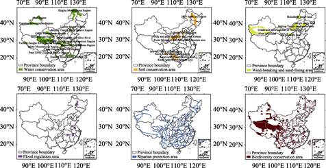
Figure 1 Data maps of spatial distribution of ecological core areas within China[11]
Land use map of ecological core areas of China is presented in Figure 2. These data show that forested and grassland areas encompassed 806,300 km2 and 1,344,400 km2, respectively, at this time, 23.7% and 39.6% of the total core national ecological area, respectively. This map also reveals that the proportion of grassland was much higher in 2008 than the national average proportion of this land use type (30.9%), while the area of forested land was slightly below the national forest proportion average (24.0%). Similarly, the area of wetland and glaciers performing important ecosystem services also reached 6.0% of total area in 2008, much higher than the national average of 2.2%, while the area of ecological conservation land encompassed 16.0% of the total core area, and the proportions of cultivated and industrial and mining construction land encompassed 13.6% and 1.1%, respectively. The areas of both these latter two land use types in 2008 were below the national average of 18.8% and 2.2%, respectively.
|

Figure 2 Land use map of ecological core areas within China[11]
|
The areas of cultivated land, industrial and mining, and construction land within the ecological core areas of China grew rapidly between the 1980s and 2008. Indeed, despite the low proportion of total land area encompassed by these two uses, their growth rates reached as high as 25.3% and 17.2%, respectively, corresponding to net increases of 93,300 km2 and 57,000 km2, respectively. The areas of other land use types decreased slightly over this time period; forested and grassland areas decreased by 24,100 km2 and 53,800 km2 respectively.
5 Conclusion
The proportions of forested, grassland, wetland, and glacier areas within ecological core zones are relatively higher than national averages, while the areas of arable, urban, rural, industrial and mining land remain relatively low. The dataset provides a reference and basic data enabling the delineation of ecological red lines, the construction of ecological protection projects, and ecological space planning of China.
Author contributions
Xu, E. Q. and Zhang, H. Q. designed the data algorithms, Xu, E. Q. contributed to data processing and analysis, and Xu, E. Q. wrote this paper.
References
[1] Shi, M. J., Ma, G. X., Shi, Y. How much real cost has China paid for its economic growth? [J]. Sustainability Science, 2011, 6(2): 135-149.
[2] Zheng, D., Yang, Q. Y., Wu, S. H. Eco-geographical Zoning in China [M]. Beijing: Commercial Press, 2008.
[3] Ouyang, Z. Y. Ecological Function Zoning in China [J]. China Survey and Design, 2007, 3: 70.
[4] Fan, J. Draft of major function oriented zoning of China [J]. Acta Geographica Sinica, 2015, 70(2): 186-201.
[5] Xu, E. Q., Zhang, H. Q. Dataset of classification and land use of the ecological core areas of China [DB/OL]. Global Change Research Data Publishing & Repository, 2016. DOI: 10.3974/geodb.2016.01.11.V1Author.
[6] GCdataPR Editorial Office. GCdataPR Data Sharing Policy [OL]. DOI: 10.3974/dp.policy.2014.05 (Updated 2017).
[7] Fisher. B., Turner, R. K., Morling, P. Defining and classifying ecosystem services for decision making [J]. Ecological Economics, 2009, 68 (3): 643-653.
[8] Zhang, R. Z., Li, B. Y., Zhang, H. X., et al. China Nature Reserve Zoning System. Beijing: Chinese Environmental Science Press, 2012.
[9] Ministry of Water Resources of P. R. China, National Bureau of Statistics of P. R. China. Bulletin of first national census for water [R]. Beijing: China Water & Power Press, 2013.
[10] Liu, J. Y. Remote Sensing Investigation and Macro Dynamics of Resource and Environment in China [M]. Beijing: China Science and Technology Press, 1996.
[11] Xu, E. Q., Zhang, H. Q. Land use structure and change of important ecological space in China and protection research [J]. Resources Sciences, 37(7): 1322-1331.