Global Change Data Encyclopedia
Ngoring Lake, Qinghai-Tibet Plateau, China
Gou, Z. J. Liu, F. G.*
Department of Geographic Sciences, Qinghai Normal University, Xining 810008, China
Keywords: Ngoring Lake; Yellow River; Qinghai-Tibet Plateau; data encyclopedia
|
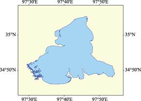
Figure 2 Ngoring Lake data visualization (.shp format)
|
|
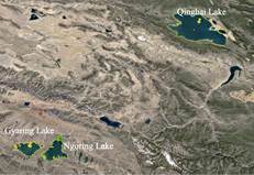
Figure 1 The geo-location of Ngoring Lake
(.kmz format)
|
Ngoring Lake is also called Bohai or Eling Lake, and it is called Cuoelang in Tibetan, meaning cyan lake (the lake is clear and azure)[1]. Ngoring Lake is located at the source of the Yellow River. The area of Ngoring Lake (2015) is 651.08 km2, the shoreline is 490.73 km, and the elevation is 4,268.70 m[2]. The water depth is 1–31 m[3]. It is the largest freshwater lake on the Qinghai-Tibet Plateau, located in Madoi county, Qinghai province. Ngoring Lake and Gyaring Lake, 11 km away from Ngoring Lake at the west, are called “Sister Lakes” in the source region of Yellow River (Figure 1). Its Geo-location is 34°46′03′′N–35°05′21′′N, 97°29′21′′E– 97°54′21′′E (Figure 2)[2].
The Ngoring Lake is a fault depression tectonic basin formed in the Late Cenozoic Yanshan Movement period at the intersection of left-lateral strike-
slip faults, Bayan Hara-southern margin of Animaqing, and the southern margin of the East Kunlun-Animaqing. The bed rocks are marl, sandstone, and shallow metamorphic rocks in Jurassic Period, covered by the sedimentary strata of Quaternary Early Pleistocene- Holocene lacustrine.
|
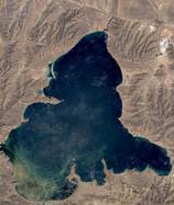
Figure 3 The remote sensing image of Ngoring Lake in 2001 (Google Earth image)
|
The Ngoring Lake is in a shape of calabash, wide in the south and narrow in the north. The widest distance is 37 km in the south, while the widest distance is 16.5 km in the north, with a distance of 11 km in the middle. Ngoring Lake flows into the Yellow River from south to north through a water channel (150 m wide and 3 km long), and then turns to east and connects the reservoir (1–4 km in north-south direction and 9 km in west-east direction) formed in 2002 in the upstream of Yellow River (Figures 3–4).
|
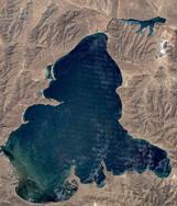
Figure 4 The remote sensing image of Ngoring Lake in 2002 (Google Earth image)
|
The transparency of the lake water is 2.0–5.0 m, the pH value is 7.8–8.4, and the salinity is 310–370 mg/L. It belongs to bicarbonate and magnesium type Ι freshwater lake[4]. The lake water is mainly supplied by surface runoff and precipitation. The annual average precipitation is 321.6 mm (Madoi weather station)[5–6]. There are planktonic algae and
zooplankton in the Lake. Fish are mainly cold-water non-phosphorus fish. Birds mainly include cormorant, whooper swan, tadorna ferruginea, black-necked crane, chukar, plateau partridge, bar-headed goose, etc.[7–8]. There are 231 islands in the Ngoring Lake, mainly distributed in the southwest of the Lake. Most islands are small and only 7 islands have the area larger than 0.1 km2. The smallest island has an area of 32 m2. The largest island, located in the northwest of the Lake, has an area of 0.62 km2, and the shoreline is 12.04 km. The dataset was developed based on Google Earth (2015) and related maps. The dataset is stored in .kmz and .shp[9] formats and consists of 22 files with a data volume of 23.1 MB (compressed to two files, 7.83 MB).
References
[1] Xue, L. China Silk Road Encyclopedia [M]. Xijiang People’s Publishing House, 1994.
[2] Gou, Z. J., Liu, F. G. Ngoring Lake [DB/OL]. Global Change Research Data Publishing & Repository, 2018. DOI: 10.3974/geodb.2018.03.14.V1.
[3] The Yellow River Water Resources Commission of the Ministry of water resources of P. R. China. Atlas of Yellow River Basin [M]. Beijing: SinoMap Press, 1989.
[4] Editorial Office of Encyclopedia of Rivers and Lakes in China. Encyclopedia of Rivers and Lakes in China: Yellow River [M]. Beijing: China Water & Power Press, 2014.
[5] Editorial Office of County Annals of Madoi. County Annals of Madoi County [M]. Beijing: China County and Town Yearbook Publishing House, 2001: 59.
[6] Editorial Office of local chronicles of Madoi County. County Annals of Madoi County [M]. Xining: Qinghai Ethnic Publishing House, 2011: 34–35.
[7] Ma, Y. X. Main Grassland Nature and Cultural Resources of China [M]. Beijing: China Agriculture Press, 2012.
[8] Zhao, K. Y. Mires of China [M]. Beijing: Science Press, 1999.
Data Computing Environment
[9] ESRI. ArcGIS campus license of Institute of Geographic Sciences and Natural Resources Research, Chinese Academy of Sciences.
URL for Data Downloading
http://www.geodoi.ac.cn/WebEn/doi.aspx?ID=642.
Or search through: http://www.geodoi.ac.cn.