CHEN Ziang1 LIN Xinyue1 YE Peng1 HE Ju2 YANG Meng1*
1. College of Civil and Transportation
Engineering, Yangzhou University, Yangzhou 225091, China;
2. Institute of Rural Revitalization (Central Jiangsu Development
Research Institute), Yangzhou University, Yangzhou 225091, China
Abstract: The Beijing-Hangzhou Grand Canal runs from Beijing
in the north to Hangzhou in the south. It was first built during the Spring and
Autumn Period, connected during the Sui Dynasty, prospered during the Tang and
Song dynasties, and reached its peak during the Ming and Qing dynasties. It is
the earliest, longest, and largest ancient canal in the world. Based on the
cultural heritage sites of the Beijing-Hangzhou Grand Canal inscribed on the
World Heritage List in 2014, the authors collected site information from
official websites, including those of the State Council of China and the
National Cultural Heritage Administration. A dataset of cultural heritage sites
along the Beijing-Hangzhou Grand Canal was then developed. The dataset includes
the sites’ names, protection levels, heritage types, construction periods, and
historical backgrounds of 697 cultural heritage
sites, comprising 58 World Cultural Heritage sites, 200 National Cultural
Heritage sites, and 439 Provincial Cultural Heritage sites. The dataset is
archived in .xlsx and .shp formats, and consists of 22 data files with data
size of 4.50 MB (compressed into one single file with 541 KB).
Keywords: Beijing-Hangzhou Grand Canal;
cultural heritage site; world heritage
DOI: https://doi.org/10.3974/geodp.2026.04.10
Dataset Availability Statement:
The dataset
supporting this paper was published and is accessible through the Digital Journal of
Global Change Data Repository at:
https://doi.org/10.3974/geodb.2026.02.04.V1.
1 Introduction
The
Beijing-Hangzhou Grand Canal is a major hydraulic engineering achievement
created by ancient Chinese laborers. It is known for its early construction,
large scale, and long waterway. As a living world-class cultural heritage, the
Grand Canal records and carries the long history and rich civilization of the
Chinese nation[1]. It is both an economic corridor linking northern
and southern China and a cultural corridor that has transmitted cultural
traditions for more than a millennium. The cultural heritage sites along the
canal are “living fossils” of the evolution of Chinese civilization. They have
important historical, scientific, and artistic value[2].
The Chinese government has
attached great importance to the protection, inheritance, and use of Grand
Canal cultural heritage. In February 2019, the Outline of the Grand Canal
cultural protection, inheritance and utilization plan[3] was issued.
The document called for deeper exploration
of the cultural connotations of the Grand Canal. It also emphasized the
establishment of a cultural heritage database and information management
platform. In December 2019, the Ministry of Water Resources and the National Cultural
Heritage Administration jointly issued the Special plan for Grand Canal
cultural heritage protection and inheritance[4]. The plan required
systematic work on the investigation, research, conservation, and
exhibition of Grand Canal cultural heritage. In August 2021, the Leading Group
for National Cultural Park Construction issued the Construction and protection
plan for the Grand Canal National Cultural
Park[5]. Its core tasks included building a cultural identity system
for the Grand Canal, creating unified archives for cultural resources,
promoting digital preservation, and developing visual, interactive, and
immersive cultural outputs[6].
Since 2014, China has
emphasized the systematic principle of “protecting, inheriting, and utilizing”
cultural heritage on many occasions. These remarks cover cultural relics,
historical and cultural cities, the Grand Canal, and revolutionary heritage.
Under this guidance, conservation and research on Grand Canal cultural heritage
in China have entered a new stage of deeper and more systematic integration.
Government departments and local authorities have jointly promoted the
investigation, evaluation, archiving, and digital preservation of Grand Canal
cultural heritage. These efforts aim to support the integral and authentic
protection of this large linear heritage system through systematic organization
and scientific documentation.
Against this background, this
dataset was developed. It systematically integrates information on cultural
heritage sites along the Beijing-Hangzhou Grand Canal, with a focus on Jiangsu
Province and other key canal sections. It covers hydraulic engineering
heritage, such as waterways, sluices, dams, and docks; settlement heritage,
such as ancient towns and villages; and related tangible cultural heritage,
including government offices, granaries, guild halls, and stone inscriptions[7].
The dataset records key attributes of 697 cultural heritage sites, including
site name, geographic coordinates, heritage type, historical period, and
preservation condition. It provides reliable basic data for academic research,
conservation planning, management decision-making, and public education. It
also supports the analysis of the spatial distribution[8] and value
characteristics of Grand Canal cultural heritage, as well as further
conservation, research, and cultural inheritance.
2 Metadata of the Dataset
Table 1 presents the metadata
of the Dataset of 697 cultural heritage sites along the Beijing-Hangzhou Grand
Canal[9]. It includes the dataset name, authors, geographical region,
year of the data, dataset files, etc.
3 Methods
3.1 Data Sources
The authors collected the list of Beijing-Hangzhou
Grand Canal cultural heritage sites inscribed on the World Heritage List[11]
in 2014. Official notices, documents released by the State Council of China,
the National Cultural Heritage Administration, and several provincial cultural
heritage authorities were used to obtain key site information. The
Table 1 Metadata summary of the Dataset of 697
cultural heritage sites along the Beijing-Hangzhou Grand Canal
|
Items
|
Description
|
|
Dataset full name
|
Dataset of 697 cultural
heritage sites along the Beijing-Hangzhou Grand Canal
|
|
Dataset short name
|
HeritageSitesBHGC
|
|
Authors
|
Chen, Z. A., College of Civil
and Transportation Engineering, Yangzhou University, 19952316609@163.com
Lin, X. Y., College of Civil
and Transportation Engineering, Yangzhou University, 19859905559@163.com
Ye, P., College of Civil and
Transportation Engineering, Yangzhou University, 007839@yzu.edu.cn
He, J., Institute of Rural
Revitalization (Central Jiangsu Development Research Institute), Yangzhou
University, torchheju@outlook.com
Yang, M., College of Civil and
Transportation Engineering, Yangzhou University, emyangmeng@163.com
|
|
Geographical region
|
Areas along the Beijing-Hangzhou
Grand Canal
|
|
Year
|
2025
|
|
Data format
|
.xlsx, .shp
|
|
Data size
|
4.50 MB
|
|
Data files
|
Information on 697 cultural
heritage sites, including geo-location, site name, protection level, heritage
type, construction period, and historical background
|
|
Foundations
|
National Natural Science
Foundation of China (42501353, 42401291); Natural Science Foundation of
Jiangsu Province (BK20230602); Ministry of Education of P. R. China
(23YJCZH265)
|
|
Computing environment
|
ArcGIS 10.2
|
|
Data publisher
|
Global Change Research Data
Publishing & Repository, http://www.geodoi.ac.cn
|
|
Address
|
No. 11A, Datun Road, Chaoyang District, Beijing
100101, China
|
|
Data sharing policy
|
(1) Data
are openly available and can be free downloaded via the Internet; (2) End
users are encouraged to use Data
subject to citation; (3) Users, who are by definition also value-added
service providers, are welcome to redistribute Data subject to written permission from the GCdataPR Editorial
Office and the issuance of a Data
redistribution license; and (4) If Data
are used to compile new datasets, the “ten percent principle” should be
followed such that Data records
utilized should not surpass 10% of the new dataset contents, while sources
should be clearly noted in suitable places in the new dataset[10]
|
|
Communication
and searchable system
|
DOI, CSTR, Crossref, DCI,
CSCD, CNKI, SciEngine, WDS, GEOSS, PubScholar, CKRSC, OARL
|
information included administrative division,
geographic coordinates, heritage type, and historical period. ArcGIS was then
used to visualize the spatial distribution of cultural heritage along the
Beijing-Hangzhou Grand Canal[12]. Table 2 shows the issuing
authorities, release dates, and numbers of published cultural heritage sites.
3.2 Technical Route
This study focused on the
cultural heritage sites of the Beijing-Hangzhou Grand Canal. It followed the
framework of “multi-source data collection-standardized processing-spatial
integration”. Data from 697 cultural heritage sites were systematically
collected and processed. Official information released by the State Council of
China, the National Cultural Heritage Administration, and other authorities was
used as the main data source. Spatial coordinate services from the Amap Open
Platform were used as supplementary sources. This approach ensured the
authority, accuracy, and reusability of the dataset. The technical route
included the following stages.
(1) Multi-source data collection and data processing
First, information on cultural heritage sites along the Beijing-Hangzhou
Grand Canal was collected from authoritative sources. These sources included
the official website of the National Cultural Heritage Administration, lists of
cultural relic protection units issued by the State Council and relevant
cultural heritage authorities, world cultural heritage
Table 2 Relevant
official notices on the cultural heritage list of the Beijing-Hangzhou Grand
Canal
|
Issuing
authority
|
Title
|
Release date
|
Number of
sites
|
|
UNESCO
|
Notice on
the issuance of the World heritage list
|
2014.6
|
58
|
|
State
Council of China
|
Notice on
the issuance of the Outline of the Grand Canal cultural protection,
inheritance and utilization plan
|
2019.2
|
188
|
|
Hebei
Provincial Cultural Heritage Administration
|
Notice on
the issuance of the Cultural heritage list of the Hebei section of the Grand
Canal
|
2025.4
|
74
|
|
Shandong
Provincial Cultural Heritage Administration
|
Notice on
the issuance of the Grand Canal heritage protection plan of Shandong Province
(2012–2030)
|
2022.4
|
152
|
|
Jiangsu
Provincial Cultural Heritage Administration
|
Notice on
the issuance of the Grand Canal cultural heritage protection, inheritance and
utilization plan of Jiangsu Province
|
2021.5
|
372
|
|
Zhejiang
Provincial Cultural Heritage Administration
|
Notice on
the issuance of the Implementation plan for cultural heritage protection,
inheritance and utilization of the Grand Canal in Zhejiang Province
|
2020.4
|
43
|
|
Anhui
Provincial Cultural Heritage Administration
|
Notice on
the issuance of the Implementation plan for cultural heritage protection,
inheritance and utilization of the Grand Canal in Anhui Province
|
2020.6
|
43
|
|
Beijing
Municipal Cultural Heritage Administration
|
Notice on
the issuance of the Construction and protection plan for the Beijing Grand
Canal National Cultural Park
|
2021.10
|
40
|
|
Tianjin
Municipal Cultural Heritage Administration
|
Notice on
the issuance of the Regulations on cultural heritage protection, inheritance
and utilization of the Grand Canal in Tianjin
|
2025.1
|
29
|
nomination documents, and
related special planning documents. Key attributes were extracted. They
included site name, batch number, protection level (such as national key
cultural relic protection unit or provincial cultural relic protection unit),
heritage type (such as sluice, dam, dock, warehouse, or bridge), construction
period, historical background, associated historical events and figures,
current preservation condition, and restoration record. Second, geocoding and
reverse geocoding services from the Amap Open Platform were used to query
locations and obtain coordinates. Longitude and latitude under the GCJ-02 were
obtained for each site. Provincial-, municipal- and county-level administrative
units were also recorded. This process established the initial link between
attribute data and spatial data.
(2) Standardization and normalization of attribute
data
Because data from different sources varied in naming
conventions, recording granularity, and wording, the raw data were
standardized. The process included 4 steps.
First, site names were standardized. The standard
names published by the National Cultural Heritage Administration and the State
Council were used as primary entries. Alternative names, including former names
and common names, were unified. Authoritative references, such as the Atlas of
Chinese Cultural Relics[13] and the Catalogue of Chinese
Cultural Heritage[14], were used for cross-validation. Second,
classifications and codes were standardized. Based on industry standards,
including the Standards for defining protection boundaries of cultural relic
protection units[15] and the Classification and codes of China’s
world cultural heritage[16], a standard classification system and
coding rules were established for enumerated fields, such as heritage type and
protection level. This step ensured consistency in data integration and
retrieval. Third, historical periods and related events were normalized.
Construction periods were recorded using a dual annotation method, with the
Gregorian calendar as the main standard and dynastic chronology as
supplementary information. Textual information, including historical
background, associated historical events, and associated historical figures,
was structurally extracted. Key information tags were then created to support
later association queries and knowledge graph construction. Finally,
preservation condition and restoration records were structured. Degree of
damage was classified into 5 levels: intact, slightly damaged, moderately
damaged, severely damaged, and site remains only. Key information from
restoration records, including time, responsible institution, and restoration
content, was extracted to build a time-series maintenance archive.
(3) Spatial location calibration and
administrative division association
Although Amap provided preliminary
coordinates, spatial location calibration was still required. This step
integrated multiple spatial data sources.
First, public map data at a scale of 1:1,000,000
released by the National Geomatics Center of China and the national
administrative division query platform of the Ministry of Civil Affairs were
used to match provincial-, municipal- and county-level administrative units.
Second, for sites with ambiguous or uncertain
coordinates, manual interpretation and correction were conducted using
historical maps, archaeological reports, and field investigation images. This
process ensured that the spatial positioning accuracy could meet the needs of
academic research and public services.
Third, the final coordinates were
transformed into the WGS84 coordinate system and organized as point features.
Each cultural heritage site was assigned a unique spatial identifier.
(4) Quality control and data publication
Cross-validation and sampling
checks were applied throughout data processing. Key attributes, including
protection level, historical period, and coordinates, were reviewed by multiple
researchers. Consistency checks and logical corrections were also applied to
textual information. The final dataset was released in open formats with
detailed metadata documentation. The documentation includes field descriptions,
collection standards, spatial reference, and usage license information. These
measures improved data reliability and usability. Through this technical route,
the study transformed multi-source heterogeneous information on Beijing-Hangzhou
Grand Canal cultural heritage into a standardized, spatialized, and structured
thematic database. The dataset provides a solid data foundation for cultural
heritage conservation and management, academic research, and public digital
services[17].
4 Data Results
4.1 Dataset Composition
The dataset contains
information on 697 heritage sites and covers 7 provincial-level administrative
regions in China. The core fields include heritage site name, administrative
affiliation (province, city, and county), protection level, heritage type, geographic
coordinates (WGS84 coordinate system), construction period, historical
background, associated historical event, associated historical figure, degree
of damage, and restoration record. These 14 attributes are shown in Table 3.
The dataset provides a comprehensive record of the basic information and
current preservation status of major cultural heritage sites along the Beijing-Hangzhou
Grand Canal.
4.2 Data Results Analysis
4.2.1 Provincial-level Distribution
The heritage sites show clear clustering at the
provincial level. Jiangsu Province has the largest number, with 550 sites,
accounting for 78.9% of the total. These sites are mainly located in canal-side
cities, including Suzhou (160 sites), Wuxi (86 sites), Yangzhou (79 sites), Changzhou
(75 sites), Zhenjiang (49 sites), and Huai’an (38 sites). Shandong Province
ranks second, with 56 sites, accounting for 8.03% of the total. Its sites are
mainly concentrated in Liaocheng (19 sites), Jining (18 sites), and Tai’an (10
sites), all of which are important nodes along the Shandong section of the
Beijing-Hangzhou Grand Canal. Zhejiang Province has 44 sites, accounting for
6.31% of the total. These sites are mainly
Table 3 Description of core fields in
the dataset
|
Basic information
|
Item
|
Description
|
Example
|
Chinese
field name
|
English
field name
|
|
Serial number
|
Serial number
|
Cultural heritage records are assigned sequential identification numbers
|
1, 2, 3, ...
|
Seq_ID
|
ID
|
|
Administra- tive division
|
Provincial-level administrative region
|
The first-level administrative division where the heritage site is
located
|
Jiangsu Province, Zhejiang Province, ...
|
Prov_CN
|
Prov_EN
|
|
Municipal-level administrative region
|
The second-level administrative division where the heritage site is
located
|
Hangzhou, Yangzhou, ...
|
Muni_CN
|
Muni_EN
|
|
County-level administrative region
|
The third-level administrative division where the heritage site is
located
|
Tianning District, Guangling District, ...
|
Coun_CN
|
Coun_EN
|
|
Heritage site name
|
Heritage site name
|
The official name of a cultural heritage site. It reflects the site’s
identity, attributes, location, and historical-cultural meaning
|
Slender West Lake, Geyuan Garden, ...
|
Heri_CN
|
Heri_EN
|
|
Protection level
|
Protection level
|
The legally valid protection grade assigned by an authoritative
institution according to the value, importance, and rarity of the heritage
|
World Cultural Heritage site, National key cultural relics protection
unit, Provincial-level cultural relics protection unit, ...
|
Prot_CN
|
Prot_EN
|
|
Heritage type
|
Heritage type
|
Ancient cultural sites, ancient tombs, ancient architecture, grotto
temples, ancient stone carvings, ancient murals, important modern and
contemporary historic sites, and representative architecture, etc.
|
Canal engineering heritage, ancient tombs, ancient sites, ...
|
Type_CN
|
Type_EN
|
|
Geographic coordinates
|
Longitude
|
The east-west position of a heritage site on the Earth’s surface,
usually expressed in decimal degrees
|
Longitude,
latitude of a heritage site (WGS84 coordinate system)
|
经度1
|
Long_1
|
|
Latitude
|
纬度1
|
Lat_1
|
|
Construction period
|
Construction period
|
The historical time or period when the main body of the heritage site
was first built or established
|
Spring and Autumn Period, Han Dynasty, Qing Dynasty, Sui and Tang
dynasties, ...
|
Cons_CN
|
Cons_EN
|
|
Historical background
|
Historical background
|
The historical context in which the heritage site was created, existed,
and developed, including political, economic, and cultural conditions
|
Historical function and status of the heritage site, ...
|
Hist_CN
|
Hist_EN
|
|
Associated historical event
|
Associated historical event
|
Important historical events or activities closely related to the
existence and value of the heritage site
|
Postal relay system, salt trade, canal governance, ...
|
Relae_CN
|
Relae_EN
|
|
Associated historical figure
|
Associated historical figure
|
Key historical figures who played important roles in the creation,
development, protection, or historical evolution of the heritage site
|
Emperor Qianlong, Emperor Yang of the Sui Dynasty, ...
|
Relap_CN
|
Relap_EN
|
|
Degree of damage
|
Degree of damage
|
An assessment of the gap between the current physical condition of the
heritage site and its complete or original condition
|
Wall peeling, partial foundation damage, ...
|
Degr_CN
|
Degr_EN
|
|
Restoration record
|
Restoration record
|
A chronological record of conservation, restoration, and intervention
activities, including time, content, techniques, and methods
|
Site conservation in 2018; structural reinforcement in 2019, ...
|
Repa_CN
|
Repa_EN
|
distributed in Hangzhou (19 sites), Shaoxing
(9 sites), and Jiaxing (3 sites). They are concentrated along the Jiangnan
Canal and the East Zhejiang Canal (Figure 1). Heritage sites spanning multiple
cities are counted in each city involved; therefore, the sum of city-level
counts may exceed the provincial total.
|
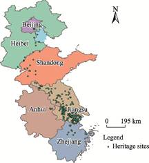
Figure 1 Detailed
distribution map of heritage sites
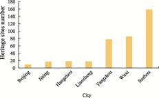
Figure 2 Core distribution of heritage
sites at the city level
|
4.2.2 Core Distribution at the City Level
At the city level, several high-density
heritage clusters can be identified (Figure 2). Yangzhou in Jiangsu Province
has 79 heritage sites, mainly in Guangling District, Gaoyou City, Hanjiang
District and Jiangdu District. Representative sites include Geyuan Garden,
Yucheng Post Station, and Shaobo Ancient Embankment. The sites include
hydraulic structures, such as Liubao Water Release Sluice, and salt merchant
residences, such as LU Shaoxu Salt Merchant Residence. They reflect Yangzhou’s
role as the “First City of the Canal” and its water transport and salt industry
culture. Wuxi in Jiangsu Province has 86 heritage sites, mainly in Liangxi
District, Yixing City, Xishan District, Jiangyin City, and Binhu District.
Representative sites include XU Xiake’s Former Residence and Qingshantang Stone
Carvings, and Jichang Garden. The sites include grotto temples and stone
carvings, such as the Guoshan Stele; ancient bridges and roads; and former
residences of notable figures, such as the Former Residence of XUE Fucheng.
They reflect Wuxi’s identity as a canal alley and Jiangnan water port, as well
as its shipping trade and water-town culture. Suzhou in Jiangsu Province has
160 heritage sites, mainly distributed in Gusu District, Wuzhong District,
Wujiang District, Changshu City, Kunshan City, Taicang City, and other areas.
Representative sites include the Suzhou section of the Jiangnan Canal, Baodai
Bridge, and Panmen. These sites feature hydraulic facilities, such as ancient
towpaths, and historic cultural districts, such as the Shantang River and
Pingjiang Street areas. They show Suzhou’s historic water-city layout and
commercial prosperity. Liaocheng in Shandong Province has 19 heritage sites,
mainly in Dongchangfu District, Linqing City, and Yanggu County. Representative
sites include Liaocheng Shanxi–Shaanxi Guild Hall and Tuqiao Sluice Site. The
sites include hydraulic remains, customs ruins, and ancient city structures.
They reflect Liaocheng’s identity as an ancient canal metropolis and its canal
trade and urban culture. Jining in Shandong Province has 18 heritage sites
concentrated in Wenshang County, Yanzhou City, Jiaxiang County, Rencheng
District, Jinxiang County, Sishui County, Zoucheng City and Weishan County.
Hydraulic engineering works, such as the Nanwang Hub and Wenshang Ten Mile Lock,
are its core features. These sites highlight Jining’s key role as the “water
ridge” of the Grand Canal. Hangzhou in Zhejiang Province has 19 heritage sites
in Gongshu District, Shangcheng District, Linping District, Binjiang
District, Xiaoshan District, Fuyang District, and Tonglu County. Representative
sites include Fuyi Granary, Xixing Guotanghang Wharf in Hangzhou, and the
Qiaoxi Historic Cultural District. They reflect Hangzhou’s functions as the
canal terminus for storage, defense, and commerce. Beijing has 10 heritage
sites, mainly in Tongzhou District, Dongcheng District, and Xicheng District. Representative
sites include Tongzhou Randeng Pagoda, Tongyun Bridge, Zhangjiawan Town Wall
Ruins, and the Tomb of LI Zhuowu. They reflect Beijing’s role as the capital
terminus of the canal and as the central hub of imperial grain transport.
4.2.3 Distribution by Construction Era
|
|
|
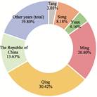
Figure 3 Distribution
of heritage sites by construction period
|
The construction periods of the heritage
sites span multiple historical stages, from prehistoric and pre-Qin periods to
the Ming and Qing dynasties and modern times. Sites dating to the Ming and Qing
dynasties account for the largest share of the dataset (Figure 3). Tang Dynasty
sites total 21, accounting for 3.01% of the dataset. They are mostly early
canal infrastructure projects, such as Ningbo Sanjiangkou in Zhejiang, which
was built during the Tang Dynasty, and Baodai Bridge in Jiangsu, built during
the Yuanhe period of the Tang Dynasty. Song Dynasty sites total 57, accounting
for 8.18%. They are mainly related to canal dredging and embankment
construction, such as Shaobo Ancient Embankment in Jiangsu, which was built in
the Song, and Water Level Stele, built during the Southern Song Dynasty. Yuan
Dynasty sites total 29, accounting for 4.16%. They are related to the full
connection of the Beijing-Hangzhou Grand Canal, such as the Jingmen Upper and
Lower Sluices in Shandong and the Suqian section of the Middle Canal in
Jiangsu. Ming Dynasty sites total 145, accounting for 20.80%. This period
marked a peak in canal construction. The sites mainly include hydraulic hubs,
such as Qingkou Hub in Jiangsu and Nanwang Hub in Shandong, and embankment works, such as the brick embankment of the canal in
Wenshang County, Shandong Province. Qing Dynasty sites total 212, accounting
for 30.42%. Canal-related heritage and ancient buildings are the most common
types in this period. This indicates active canal construction and broader
architectural development. Ancient tombs are also common, suggesting notable
burial-related cultural activities. Republic of China sites total 95,
accounting for 13.63%, which are relatively numerous.
5 Discussion and Conclusion
This dataset systematically organizes the
basic information of 697 heritage sites along the Beijing-Hangzhou Grand Canal.
It covers spatial distribution, functional types, historical background, and
preservation condition. It clearly shows the overall characteristics of Grand
Canal cultural heritage. At the provincial level, the sites are highly concentrated
in Jiangsu Province, followed by Shandong and Zhejiang. This pattern reflects
Jiangsu’s central role in the Grand Canal heritage system. At the city level, Suzhou,
Wuxi, Yangzhou, and other cities form several dense heritage clusters. These
clusters reflect diverse functions, including grain transport and salt industry
culture, water-town commerce, hydraulic hubs, and the grain transport functions
of capital cities. In terms of construction period, sites from the Song Dynasty
account for 8.18%. During the Ming and Qing dynasties, the total amount of
heritage accounted for 51.22%, while during the Republic of China period, it
accounted for 13.63%. This reflects the cultural accumulation of the Grand
Canal during its heyday in the Ming and Qing dynasties and its continued
development in modern times.
The dataset also shows a strong coupling
between heritage distribution and canal function. The spatial distribution of
heritage sites closely corresponds to the Grand Canal system of “grain
transport corridor-hydraulic node-commercial city”. The seven core
cities—Suzhou, Wuxi, and Yangzhou in Jiangsu Province; Liaocheng and Jining in
Shandong Province; Hangzhou in Zhejiang Province; and Beijing—contain 56.10% of
all heritage sites. These cities were all key hubs of canal transportation. For
example, Yangzhou functioned as a salt transport center, while Jining served as
a water regulation center. This distribution confirms the interactive
relationship that “the canal shaped cities, and cities preserved heritage”. It
also provides a spatial basis for coordinated regional heritage conservation.
This dataset supports research on the spatial
distribution of Grand Canal cultural heritage and the formulation of
conservation strategies. It also provides a reference for cross-regional
collaborative heritage management and cultural inheritance. Future studies may
further incorporate heritage monitoring data to improve the dataset’s dynamic
updating capacity and application value.
Author Contributions
Chen Z. A. and Lin, X.
Y. contributed to the overall design of the dataset. Ye, P. and He, J.
collected and processed the heritage site data. Yang, M. designed the models
and algorithms. Chen Z. A., He, J., and Ye, P. verified the data. Lin, X. Y.
and Yang, M. wrote the data paper.
Conflicts of Interest
The
authors declare no conflicts of interest.
References
[1]
Zhao,
J. H., Li, P. B., Wu, J. The enlightenment of the planning and construction of
the archaeological site park of Nanwang Hub of Beijing-Hangzhou Grand Canal
[J]. Urbanism and Architure, 2025, 22(14): 177–180.
[2]
Fang, X. B., Gu, L. M., Chen, Y.,
et al. The Beijing-Hangzhou Grand Canal: the vital link between Northern
and Southern China [J]. Cultural Geography, 2024(15): 14–25.
[3]
General Office of the CPC
Central Committee, General Office of the State Council. Outline of the Grand
Canal cultural protection, inheritance and utilization plan [Z]. 2019: 15–20.
[4]
National Cultural Heritage
Administration, Ministry of Culture and Tourism, National Development and
Reform Commission. Special plan for Grand Canal cultural heritage protection
and inheritance [Z]. 2020: 15–20.
[5]
National Cultural Park
Construction Work Leading Group. Construction and protection plan for the Grand
Canal National Cultural Park [Z]. 2021: 15–20.
[6]
Xu,
Y. Q., Wang, J., Feng, X. H. Cities and towns flourished along the water
transport routes: a city-building philosophy driven by canal-induced prosperity
[J]. City Planning Review, 2025, 49(6): 121–122.
[7]
Tian, S. The mechanism of
socio-ecological resilience in the traditional landscape space of the Nanwang
Water Diversion Hub, Beijing-Hangzhou Grand Canal [D]. Jinan: Shandong Jianzhu
Univeristy, 2024.
[8]
Jiao, M., Lu, L., Li, T. Y.
Spatial distribution characteristics and the relevant influencing factors of
intangible cultural heritage in the Grand Canal Cultural Belt [J/OL]. Journal
of Zhejiang University (Science Edition), 2025, 52(5): 591–604.
[9]
Chen, Z. A., Lin, X. Y., Ye,
P., et al. Dataset of 697 cultural heritage sites along the
Beijing-Hangzhou Grand Canal [J/DB/OL]. Digital Journal of Global Change
Data Repository, 2026. https://doi.org/10.3974/ geodb.2026.02.04.V1.
[10]
GCdataPR Editorial Office.
GCdataPR data sharing policy [OL]. https://doi.org/10.3974/dp.policy.2014.05
(Updated 2017).
[11]
UNESCO World Heritage Centre.
World Heritage List [G/OL]. 2025. https://whc.unesco. org/en/list/.
[12]
Lan, X., Luo, Y., Li, W.
Research on the spatiotemporal pattern of cultural heritage in cities along
Beijing-Hangzhou Grand Canal [J]. Urbanism and Architecture, 2025,
22(9): 10–13.
[13]
National
Cultural Heritage Administration. Atlas of Chinese Cultural Relics: Beijing
Volume, Tianjin Volume, Shandong Volume, Jiangsu Volume, Zhejiang
Volume, Anhui Volume [M]. Beijing: Cultural Relics Publishing House, 2008,
2015.
[14]
National
Cultural Heritage Administration. Catalogue of Chinese Cultural Heritage
[G/OL]. 2024. http://www.ncha.gov.cn/col/col2262/index.html.
[15]
Beijing Municipal Market
Supervision and Administration Bureau. Standards for defining protection
boundaries of cultural relic protection units (DB11/T 2228—2024) [S]. Beijing:
Beijing Municipal Market Supervision and Administration Bureau, 2024: 5–8.
[16]
National
Cultural Heritage Administration. Classification and codes of China’s world
cultural heritage (WW/T 0001—2017) [S]. Beijing: National Cultural Heritage
Administration, 2017: 4–8.
[17]
Xie, S. H., Zhao, C. L.
Evaluation of high-quality development and its spatial differences in the
Beijing-Hangzhou Grand Canal city belt [J]. Geography and Geo-Information
Science, 2025, 41(3): 139–144+152.