Wind Erosion Modulus Dataset Development for the Aral Sea
and Surrounding Regions in Central Asia (1990–2020)
YU Yao1 YAO Feng2* LI Changjun1
1. Arid Land Ecology and
Resources Science Data Center, Xinjiang Institute of Ecology and Geography,
Urumqi 830011, China;
2. State Key Laboratory of Ecological Safety and
Sustainable Development in Arid Lands, Xinjiang Institute of Ecology and
Geography, Urumqi 830011, China
Abstract: The ecological crisis
triggered by the shrinkage of the Aral Sea represents a major environmental
challenge along the “Belt and Road” route, with soil wind erosion serving as a
key process driving salt-dust storms and land degradation. To systematically
uncover the long-term evolutionary patterns of soil wind erosion in the Aral
Sea region and its surroundings in Central Asia, this study developed an annual
wind erosion modulus dataset for the period 1990–2020. This was achieved by
integrating multi-source geospatial data on the Google Earth Engine (GEE)
platform based on the Revised Wind Erosion Equation (RWEQ). The dataset
incorporates MODIS vegetation indices,
ESA-CCI land cover data, SRTM elevation data, and ERA5-Land
meteorological reanalysis data, which were processed for coordinate system
unification, resolution alignment, and spatiotemporal consistency to generate a
31-year sequence of wind erosion modulus at a spatial resolution of 1 km. Data
analysis indicates that the dried-up Aral Sea bed is the primary source area
for regional wind erosion, with a notable shift in the erosion core from the
inner lakebed to its periphery since 2012, reflecting the dynamic evolution of
erosion patterns. To validate the reliability of
the dataset, simulated results were compared with measured dust flux data
recorded at Aral Sea dust monitoring
stations (2000–2005) and derived
aerosol optical depth (AOD), validating the accuracy and reliability of the
dataset in representing wind erosion dynamics in the Aral Sea region. This
dataset can serve as a critical data foundation for assessing land degradation,
evaluating the effectiveness of ecological restoration projects in the Aral Sea
region, and supporting ecological security research for the “Green Silk Road”.
Additionally, it provides valuable data support for research and education in
geography, ecology, soil and water conservation sciences, and related fields.
Keywords: mulita-source remote; RWEQ model; Aral Sea; interannual
variation; Central Asia
DOI: https://doi.org/10.3974/geodp.2026.01.10
Dataset Availability Statement:
The dataset
supporting this paper was published and is accessible through the Digital Journal of
Global Change Data Repository at:
https://doi.org/10.3974/geodb.2025.12.01.V1.
The Central Asian Aral Sea, located in the
hinterland of Eurasia and formerly the world’s fourth‑largest lake, has become
one of the most serious environmental disasters since the 20th century. Since
the 1960s, climate change combined with intensive human activities has
drastically disrupted the water‑resource balance of the Aral Sea Basin. As a
result, the lake has continuously shrunk, losing over 90% of its water area by
the early 21st century[1,2]. With the large-scale exposure of the
lakebed, the regional surface albedo, evapotranspiration pattern, and local
climatic conditions have changed significantly, further exacerbating the land
degradation process[3,4]. The dried sediments of the former lakebed
have become a major source of salt‑dust storms and sandstorms. Large quantities
of saline dust are transported over long distances by prevailing westerly
winds, posing potential ecological threats to northwestern China[3].
The Aral Sea ecological crisis[5–7] is not only a regional challenge
in Central Asia, but also a major environmental issue affecting the ecological
security pattern of the “Green Silk Road Economic Belt”, which has attracted
great attention from China and Central Asian countries.
In this
context, the Aral Sea region has become a representative area for studying the
coupled interactions among land use, hydrology, and climate, as well as their
ecological response in arid regions[8]. Since soil wind erosion is a
key driving process that triggers the ecological crisis in the Aral Sea,
systematically carrying out research on dynamic monitoring and risk assessment
of wind erosion in this region is of great practical significance for implementing
the China-Central Asia Summit’s initiative on “promoting the solution of the
ecological crisis in the Aral Sea” and jointly building a China-Central Asia
community with a shared future. To support relevant research and
decision-making, high-resolution, long- time series soil wind erosion data has
become an urgent need. Currently, the combination of remote sensing and wind
erosion models has been widely used in regional-scale wind erosion assessment[9–11]
among which the revised wind erosion equation (RWEQ) has shown good
applicability in arid and semi-arid regions due to its highly accessible
parameters and clear physical mechanisms[12]. However, existing data
products still have problems of insufficient spatiotemporal resolution or weak
validation around the Aral Sea[13].
Based on
multi-source remote sensing and reanalysis data, this dataset realizes the
regional application and long-term simulation of the RWEQ model on the Google
Earth Engine platform, which can be used to analyze the spatiotemporal
differentiation law of soil wind erosion during the shrinkage of the Aral Sea[14],
identify wind erosion hotspots and evolution trends, and provide key data
support for regional land degradation assessment, ecological engineering
benefit monitoring[15], and collaborative ecological security
governance of the “Belt and Road”.
2 Metadata of the Dataset
The metadata of the Wind erosion modulus
dataset for the Aral Sea and surrounding regions in Central Asia (1990–2020)[16] is summarized in Table 1. It includes the dataset full
name, short name, authors, year of the dataset, temporal resolution, spatial
resolution, data format, data size, data files, data publisher, and data
sharing policy, etc.
Table 1 Metadata summary of the Wind
erosion modulus dataset for the Aral Sea and surrounding regions in Central
Asia (1990–2020)
|
Items
|
Description
|
|
Dataset full name
|
Wind erosion modulus dataset
for the Aral Sea and surrounding regions in Central Asia (1990–2020)
|
|
Dataset short name
|
AralSea_WEMD_1990-2020
|
|
Authors
|
Yu, Y., Xinjiang Institute of
Ecology and Geography, Arid Land Ecology and Resources Science Data Center,
yuyao@ms.xjb.ac.cn
Yao, F., Xinjiang Institute of
Ecology and Geography, State Key Laboratory of Ecological Safety and
Sustainable Development in Arid Lands,
yaofeng@ms.xjb.ac.cn
|
|
Geographical region
|
Aral Sea Basin (44°N–47°N, 58°E–62°E)
|
|
Year
|
1990–2020
|
|
Temporal resolution
|
Year
|
|
Spatial resolution
|
1 km
|
|
Data format
|
.tif
|
|
|
|
Data size
|
260 MB
|
|
|
|
Data files
|
Wind erosion modulus data for
the Aral Sea and surrounding regions in Central Asia
|
|
Foundations
|
Department of Science and
Technology of Xinjiang Uygur Autonomous Region (2024E02030,PT2406)
|
|
Data publisher
|
Global
Change Research Data Publishing & Repository, http://www.geodoi.ac.cn
|
|
Address
|
No. 11A, Datun
Road, Chaoyang District, Beijing 100101, China
|
|
Data sharing policy
|
(1) Data are openly available and can be free downloaded via the
Internet; (2) End users are encouraged to use Data subject to citation; (3) Users, who are by definition also
value-added service providers, are welcome to redistribute Data subject to written permission
from the GCdataPR Editorial Office and the issuance
of a Data redistribution license;
and (4) If Data are used to compile
new datasets, the “ten percent principal” should be followed such that Data records utilized should not surpass
10% of the new dataset contents, while sources should be clearly noted in
suitable places in the new dataset[17]
|
|
Communication and searchable system
|
DOI,
CSTR, Crossref, DCI, CSCD, CNKI, SciEngine, WDS, GEOSS, PubScholar,
CKRSC
|
3 Methods
This dataset integrates multi-source remote
sensing, reanalysis and observation data to drive the calculation and
validation of wind erosion modulus in the study area. The data used are
summarized in Table 2.
Table 2 Data sources
|
No.
|
Data type
|
Data source
|
Data content
|
Spatial
resolution
|
Time
range
|
|
1
|
Ground
observation
|
NOAA
|
Meteorological station data (wind speed,
etc.)
|
–
|
1990–2023
|
|
2
|
Meteorological
data
|
ECMWF
ERA5-Land
|
Wind speed, temperature, precipitation,
snow depth
|
1 km
|
1990–2023
|
|
3
|
Remote
sensing
|
MODIS
|
Land surface temperature, vegetation
cover, aerosol optical depth
|
1 km
|
1990–2023
|
|
4
|
Land cover
data
|
ESA
CCI
|
Global
land-cover data
|
300 m
|
1990–2023
|
|
5
|
Topographic
data
|
SRTM
|
Elevation
data
|
30 m
|
–
|
|
6
|
Soil data
|
HWSD
|
Soil properties (texture, organic matter,
etc.)
|
1 km
|
–
|
|
7
|
Field sampling
|
Kazakhstan
Aral
Sea
dry lakebed
|
Soil
sampling data (29 sites)
|
–
|
June 2018
|
|
8
|
Dust/salt
monitoring
|
Aral Sea
Dust
Monitoring Stations
|
Dust/salt
deposition data
|
–
|
2000–2005
|
3.1 Data Preprocessing
This dataset uses the ERA5-Land reanalysis
dataset released by the European Centre for
Medium-Range Weather Forecasts (ECMWF) as the primary meteorological data
source. The dataset provides hourly estimates of near-surface wind speed,
temperature, and precipitation with a spatial resolution of 0.1° (approximately
10 km). To improve the reliability of wind speed inputs, daily observational
records from NOAA (National Oceanic and Atmospheric
Administration) ground stations in the study area were incorporated, and a
quantile mapping method was applied to systematically correct biases in the
ERA5 Land wind speed data. Validation shows that the corrected data align well
with measured values, with a coefficient of determination (R2) exceeding 0.87.
The remote
sensing dataset forms the core of spatial analysis. This dataset extracts 1-km
spatial resolution normalized difference vegetation index (NDVI),
aerosol optical depth (AOD), and land surface temperature (LST) from
Moderate Resolution Imaging Spectroradiometer (MODIS) data. The vegetation
index was derived from the MOD13A2 product (U.S. Geological Survey/NASA) and undergoes
Z-score standardization to reduce sensor-specific biases. Land cover data is
obtained from the European Space Agency’s Climate Change Initiative project’s
300-m resolution dataset and aggregated to 1-km resolution using a
majority resampling method. Topographic data was acquired from the Shuttle Radar Topography
Mission (SRTM) at a 30-m resolution and upscaled to 1 km using a mean
resampling method to match other data sources.
To ensure
temporal consistency and interannual comparability, all datasets were projected
to the WGS 1984 geographic coordinate system and resampled to a consistent 1-km
spatial resolution using bilinear interpolation (for continuous variables) and
nearest neighbor method (for categorical data). For NDVI, AOD, and
precipitation data, a five-year moving- average filter was applied for
temporal smoothing to effectively suppress short-term anomalies and sensor
noise.
The soil
attribute information was extracted from the Harmonized World Soil Database with a spatial resolution of 1 km, including
key parameters such as soil texture, organic matter content, and calcium
carbonate content, which are core inputs for calculating the soil erodibility
factor in the RWEQ model. Through validation of data from 29 field sampling
points, the errors in soil parameters were well controlled within acceptable
limits (texture ±5%, organic matter ±0.5%).
3.2 The Revised Wind Erosion
Equation Model
The Revised Wind
Erosion Equation (RWEQ) is an erosion estimation model developed based on
empirical methods. Its core mechanism lies in comprehensively simulating the
combined effects of multiple factors on the wind erosion process, such as
climate (e.g., wind speed, precipitation), soil (e.g., erodibility component
content), and surface cover (e.g., vegetation, roughness). It has become a widely used tool for quantifying
the intensity of soil wind erosion in arid and semi-arid regions[18–20].
In this study, the key input parameters of the RWEQ model were derived from remote sensing
and meteorological datasets. The wind erosion rate per unit area is calculated
as
follows:
 (1)
(1)
 (2)
(2)
 (3)
(3)
where  is the soil erosion rate (t/(hm2·a)),
  is the maximum
soil transport rate (kg/m), and z is
the distance downwind where maximum erosion occurs (m). The model assumes that
maximum wind erosion occurs at the midpoint of the field (z ≈ S/2), and S is the
plot length (m), WF is the climatic
factor, EF is the soil erodibility factor, SCF is the soil crust
factor,
is the maximum
soil transport rate (kg/m), and z is
the distance downwind where maximum erosion occurs (m). The model assumes that
maximum wind erosion occurs at the midpoint of the field (z ≈ S/2), and S is the
plot length (m), WF is the climatic
factor, EF is the soil erodibility factor, SCF is the soil crust
factor,  is the surface roughness factor, C is the vegetation cover factor.
The climatic factor (WF)
is calculated as:
 (4)
(4)
where SW
represents soil moisture (%), SD
denotes the snow cover factor, u2
indicates measured wind speed at 2 m (m/s), u1 is the threshold wind speed at 2 m (assumed 5 m/s) (u2>u1), N
is the number of wind-speed-observation periods, Nd refers to the number of days (d), is the air density (kg/m3), and g represents gravitational acceleration
(m/s2).
is the air density (kg/m3), and g represents gravitational acceleration
(m/s2).
The soil erodibility factor (EF) and soil crust factor (SCF)
are calculated as:
 (5)
(5)
 (6)
(6)
where SA, CL, and SI denote the percentages of sand, clay, and silt, respectively (%), OM represents the soil organic matter
content (%), and CaCO3
represents the calcium carbonate
content (%). The vegetation cover factor (C) is calculated for 5 land cover types (forest, shrubland,
grassland, cropland, and bare land) using the following Equation:
 (7)
(7)
where is a vegetation-specific
coefficient, and SC denotes the
vegetation cover derived from NDVI (%). These
vegetation-specific coefficientswere adopted from Fryrear[21]
for arid environments,
with values of 0.153,5 (forest), 0.092,1 (shrubland), 0.151,1 (grassland),
0.043,8 (cropland), and 0.076,8 (bare land), consistent with the land cover
types in the study area.
is a vegetation-specific
coefficient, and SC denotes the
vegetation cover derived from NDVI (%). These
vegetation-specific coefficientswere adopted from Fryrear[21]
for arid environments,
with values of 0.153,5 (forest), 0.092,1 (shrubland), 0.151,1 (grassland),
0.043,8 (cropland), and 0.076,8 (bare land), consistent with the land cover
types in the study area.
3.3 Google Earth Engine Platform
Computation
Google Earth Engine (GEE) was used as the computational
platform for this study. Its unique cloud-based architecture effectively
addresses 3 key challenges in large-scale wind erosion simulation. First, the
GEE’s built-in parallel computing capability supports efficient processing of
31 years of temporal data (1990–2020) for the Aral Sea region. Second, the
platform integrates multi-source geospatial datasets, including MODIS surface
reflectance products, ERA5-Land meteorological reanalysis data, and SRTM elevation
data, enabling seamless data access and unified management. Third, its
optimized spatial analysis functions ensure the feasibility of regional-scale
simulations while maintaining pixel-level computational accuracy at a 1-km
resolution. The integrated framework of GEE demonstrates exceptional
computational efficiency, requiring only 1 day to fully generate a 31-year
annual spatial dataset of wind erosion modulus, providing critical technical
support for long-term, large-scale wind erosion simulation studies.
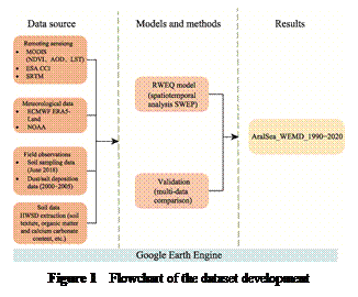 The
technical workflow of this study is illustrated in Figure 1. This computational
framework consists of 3 main steps. First, during the data preprocessing stage,
meteorological datasets (ERA5, NOAA) and land cover datasets (MODIS, ESACCI)
were resampled to a 1-km resolution to ensure spatial consistency, and wind
speed data were corrected using bias adjustment techniques to improve accuracy.
Second, the RWEQ model was applied to calculate the spatiotemporal distribution
of wind erosion rates from 1990 to 2020. Finally, the optimized model was used
to simulate monthly-scale soil wind erosion potential in the Aral Sea Basin
from 1990 to 2020, generating a continuous spatiotemporal dataset. The
simulated erosion rates were subsequently validated and calibrated using dust
flux observations and satellite-derived aerosol optical depth (AOD) data.
The
technical workflow of this study is illustrated in Figure 1. This computational
framework consists of 3 main steps. First, during the data preprocessing stage,
meteorological datasets (ERA5, NOAA) and land cover datasets (MODIS, ESACCI)
were resampled to a 1-km resolution to ensure spatial consistency, and wind
speed data were corrected using bias adjustment techniques to improve accuracy.
Second, the RWEQ model was applied to calculate the spatiotemporal distribution
of wind erosion rates from 1990 to 2020. Finally, the optimized model was used
to simulate monthly-scale soil wind erosion potential in the Aral Sea Basin
from 1990 to 2020, generating a continuous spatiotemporal dataset. The
simulated erosion rates were subsequently validated and calibrated using dust
flux observations and satellite-derived aerosol optical depth (AOD) data.
4 Data Results and Validation
4.1 Dataset Composition
The dataset of wind erosion modulus for the Aral Sea region
and surrounding areas in Central Asia contains 31 spatial datasets of soil wind
erosion modulus from 1990 to 2020. All data are archived in .tif format at a spatial resolution of 1 km, with pixel
values expressed in kg/m2/y. The naming convention for the data
files follows: ASSR-WEMD- Year.tif, where ASSR stands for “Aral Sea and
Surrounding Regions”, WEMD represents “Wind Erosion
Modulus Dataset”, and Year represents the four-digit year. For example,
ASSR-WEMD-2010.tif represents the raster data of soil wind erosion modulus for
the year 2010 in this region.
All layers in this dataset share a unified geographic
coordinate system and pixel size, facilitating time-series analysis and spatial
modeling. Each .tif file contains a single-band
floating-point raster layer, where the pixel value indicates the average annual
wind erosion modulus at that location. To illustrate the dataset’s
characteristic temporal patterns, 3 representative years are selected for
explanation: (1) ASSR-WEMD-2005.tif, the year with the lowest wind erosion
modulus, reflecting the weakening phase of wind erosion activity from the early
to mid-period. (2) ASSR-WEMD-2010.tif, a critical transitional year when wind
erosion modulus exhibited a significant increase. (3) ASSR-WEMD-2015.tif, the
year with the peak wind erosion modulus in the entire time series, marking the
phase of highest erosion intensity.
4.2 Data Results
Figure 2 illustrates the spatial distribution of wind
erosion modulus across 31 annual layers from 1990 to 2020. In terms of overall
interannual variation, the Aral Sea Basin, particularly its eastern dried-up
lakebed area, consistently remained the core region of erosion, with the
intensity generally showing an increasing trend. Notably, beginning around
2012, erosion within the lakebed weakened, while erosion intensity in the
surrounding areas notably intensified. This indicates that the erosion extent
is expanding and that the primary erosion source has gradually shifted from the
exposed central lakebed to the vegetation degraded, soil-fragile coastal
regions and adjacent regions.
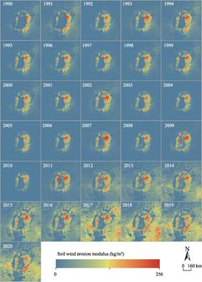
Figure 2 Interannual spatial distribution maps of
soil wind erosion model (1990–2020)
Over
the entire study period from 1990 to 2020, the regional soil wind erosion
modulus exhibited a significant mean annual increase of 0.33 kg/m2,
with spatial variability ranging from –1.2 to 5.09 kg/m2.
Among these, areas experiencing severe intensification of wind erosion (annual
growth rate>1.8 kg/m2) were primarily
concentrated in 3 types of regions: the newly dried-up central lakebed of the
Aral Sea, the active sandy areas of the Kyzylkum
Desert, and the fragile surface regions of the western plateau. These regions
share common characteristics such as loose surface material and extremely low
vegetation coverage, making them highly sensitive to wind disturbance and
environmental changes. In contrast, surrounding around the remaining water
bodies in the northern Aral Sea and the irrigated oasis zones in the lower
deltas of the Syr Darya and Amu Darya rivers exhibited minimal annual change
rates (<0.1 kg/m2). This is primarily attributed to the
relatively stable vegetation cover maintained by water bodies or irrigation,
which effectively suppresses wind erosion development.
4.3 Data Validation
To assess the accuracy and reliability of the annual
spatial dataset of wind erosion modulus for the Aral Sea region in Central Asia
from 1990 to 2020, this study employed a multi-source cross-validation approach
to systematically compare the consistency between simulation results and
independent observational datasets.
First, the measured dust flux data recorded by monitoring
stations in the Aral Sea region (2000–2005) were compared with simulated wind
erosion modulus values at corresponding locations. The results indicate a high
degree of consistency in spatial patterns between the two, with a strong
correlation (r=0.72, p<0.05),
demonstrating that the model can reliably capture the spatiotemporal variation
characteristics of regional wind erosion. Furthermore, a regional correlation
analysis was conducted between the simulated annual wind erosion modulus and
satellite-derived aerosol optical depth (AOD). The analysis revealed a highly
significant interannual correlation (r=0.85, p<0.001), indicating strong consistency between the simulation
outputs and remote‑sensing indicators of atmospheric dust load. Together, this
multi-source evidence collectively validates the accuracy and reliability of
the dataset in representing wind erosion dynamics in the Aral Sea region.
5 Discussion and Conclusion
This dataset is archived in .tif
format and can be directly read, visualized, spatially queried, statistically
analyzed, and mapped using mainstream geographic information and remote- sensing
platforms such as ArcGIS, QGIS, ENVI, and Google Earth Engine. It is well
suited for analyzing interannual trends in soil wind erosion modulus,
identifying spatiotemporal pattern evolution, and studying driving mechanisms
in the Aral Sea region from 1990 to 2020. It
can also serve as foundational data for wind erosion risk assessment, land
degradation monitoring, and evaluations of ecological governance effectiveness.
Additionally, this dataset can be used as input data for future wind erosion
scenario simulations, providing scientific support for ecological restoration
and regional sustainable development decision- making in the Aral Sea region.
This
study also highlights several areas for future improvement and refinement. (1)
Optimization of models and input data: The current model primarily relies on
satellite remote sensing and reanalysis data. Future work could incorporate
higher spatiotemporal resolution remote sensing products (e.g., Sentinel series
data) and incorporate key parameters such as field-measured wind speed and soil
properties to further enhance the model’s simulation accuracy, particularly in
characterizing local microtopography and soil heterogeneity. (2) Refinement of
process-based mechanisms: The existing framework is mainly based on the RWEQ
for interannual-scale simulations. Future research could incorporate more
complex wind erosion process models or couple hydrological and vegetation
dynamics models to more finely capture daily/ seasonal-scale wind erosion
events, the effects of soil moisture and freeze-thaw cycles, and the feedback
mechanisms between vegetation dynamics and wind erosion processes. (3)
Expansion of application scenarios and decision support potential: Future
studies could combine this dataset with regional climate models and land-use
change scenarios to conduct high-resolution wind erosion risk prediction and
early warning research. Additionally, efforts could be made to integrate wind
erosion modulus data with ecosystem service assessment models and socioeconomic
data to quantify the economic and social impacts of wind erosion disasters,
thereby providing stronger decision support for formulating more targeted
ecological restoration and adaptive management strategies.
Through continuous improvements in these areas, future work
is expected to further deepen our understanding of wind‑erosion processes in
the Aral Sea region and to provide more precise, forward-looking assessment
tools and data foundations for other wind- erosion-prone arid and semi-arid
regions worldwide.
Author Contributions
Yu, Y. handled data statistics and
authored the data paper; Yao, F. oversaw the overall design of the dataset
development, data quality control, and paper revisions; Li, C. J. contributed to the data validation.
Conflicts
of Interest
The
authors declare no conflicts of interest.
References
[1]
Micklin, P. The past, present,
and future Aral Sea [J]. Lakes & Reservoirs: Research
& Management, 2010, 15(3): 193–213.
[2]
Gaybullaev, B., Chen, S. C.,
Kuo, Y. M. Large-scale desiccation of the Aral Sea due to
over-exploitation after 1960 [J]. Journal of Mountain Science, 2012, 9:
538–546.
[3]
Indoitu, R., Orlovsky, N., Orlovsky, L. Dust emission and environmental
changes in the dried bottom of the Aral Sea [J]. Aeolian Research, 2015,
17: 101–115.
[4]
Shibuo, Y., Jarsjö, J., Destouni,
G. Hydrological responses to climate change and irrigation in the Aral Sea
drainage basin [J]. Geophysical Research Letters, 2007, 34(21): L21406.
[5]
He, M. Z., Gao, X., Zhao, Z. Y.,
el al. The ecological crisis of the Aral Sea: desertification trends and
ecological restoration and prevention strategies [J]. Bulletin of the
Chinese Academy of Sciences, 2021, 36(2): 130–140.
[6]
Deng, M. J., Long, A. H.
Analysis of hydrological and water resource evolution in the Aral Sea Basin and
solutions to the Aral Sea ecological crisis [J]. Glaciers and Frozen Soil,
2011, 33(6): 1363–1375.
[7]
Destouni, G., Jaramillo, F., Prieto, C. Hydroclimatic shifts driven by human
water use for food and energy production [J]. Nature Climate Change,
2013(3): 213–217.
[8]
Kristopher, D. W. Nature-society
linkages in the Aral Sea region [J]. Journal of Eurasian Studies, 2013,
4(1): 18–33.
[9]
Lesimuchu. Assessment of soil wind erosion and research on windbreak and sand
fixation service flows in Northwest China, 1980–2015 [D]. Xi’an: Chang’an University, 2019.
[10]
Zhang, Q. Q., Gu, F., Zhang, S.
C., et al. Spatiotemporal variation in wind erosion in Tarim River Basin
from 2010 to 2018 [J]. Land, 2024, 13(3): 330.
[11]
Jiang, H. T., Gao, W. B., Liu, B.
Y., et al. Quantifying soil wind erosion attribution in Inner Mongolia’s
desert grassland [J]. Scientific Reports, 2025(15): 14319.
[12]
Borrelli, P., Robinson, D. A.,
Panagos, P., et al. Land use and climate change impacts on global soil
erosion by water (2015–2070) [J]. Proceedings of the National Academy of
Sciences of the United States of America, 2020, 117(36): 21994–22001.
[13]
Jiang, L. L., Jiapaer, G., Bao, A. M., et al. Monitoring the
long-term desertification process and assessing the relative roles of its
drivers in Central Asia [J]. Ecological Indicators, 2019, 104: 195–208.
[14]
Lin, J. K. Spatio-temporal
variation of soil erosion and its driving factors in the Hexi Corridor [D].
Lanzhou: Lanzhou University, 2020.
[15]
Li, J. Y., Yang, X. C., Jin, Y.
X., et al. Monitoring and analysis of grassland desertification dynamics
using Landsat images in Ningxia [J]. Remote Sensing of Environment,
2013, 138: 19–26.
[16]
Yu, Y., Yao, F. Wind erosion modulus
dataset for the Aral Sea and surrounding regions in Central Asia (1990–2020)
[J/DB/OL]. Digital Journal of Global Change Data Repository, 2025.
https://doi.org/10.3974/ geodb.2025.12.01.V1.
[17]
GCdataPR Editorial Office. GCdataPR data sharing policy
[OL]. DOI: 10.3974/dp.policy.2014.05 (Updated in 2017).
[18]
Evans, J., Geerken, R.
Discrimination between climate and human-induced dryland degradation [J]. Journal
of Arid Environments, 2004, 57(4): 535–554.
[19]
Chen, Z., Liu, J. Y., Hou, X.
T., et al. Detection and attribution of greening and land degradation of
dryland areas in China and America [J]. Remote Sensing, 2023, 15(10):
2688.
[20]
Borrelli, P., Lugato, E., Montanarella,
L., et al. A new assessment of soil loss due to wind erosion in European
agricultural soils using a quantitative spatially distributed modelling
approach [J]. Land Degradation & Development, 2017, 28(1):
335–344.
[21]
Fryrcar, D. W., Chen, W. N.,
Lester, C. Revised wind erosion equation [J]. Annals of Arid Zone,
2001, 40(3): 265–279.