JIANG Zhaocai
Institute
of Geographic Science and Natural Resources Research, Chinese Academy of
Science, Beijing 100101, China
DOI: https://doi.org/10.3974/geodp.2026.04.15
 As the world’s longest and most massive man‑made waterway, the Beijing-Hangzhou
Grand Canal was inscribed in 2006 as a Major Historical and Cultural Site
Protected at the National Level (sixth batch). In 2013, the State Council of
China expanded the designation to the broader “Grand Canal of China” (seventh
batch), which encompasses the Beijing-Hangzhou Grand Canal, the Sui-Tang Grand
Canal, and the Eastern Zhejiang Canal. This integrated heritage was
subsequently inscribed on the UNESCO World Heritage List in 2014.
As the world’s longest and most massive man‑made waterway, the Beijing-Hangzhou
Grand Canal was inscribed in 2006 as a Major Historical and Cultural Site
Protected at the National Level (sixth batch). In 2013, the State Council of
China expanded the designation to the broader “Grand Canal of China” (seventh
batch), which encompasses the Beijing-Hangzhou Grand Canal, the Sui-Tang Grand
Canal, and the Eastern Zhejiang Canal. This integrated heritage was
subsequently inscribed on the UNESCO World Heritage List in 2014.
 This
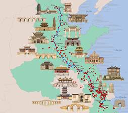
cover is designed based on the Dataset of
697 cultural heritage sites along the Beijing-Hangzhou Grand Canal1
and the Beijing-Hangzhou Grand Canal2, both published in the Digital
Journal of Global Change Data Repository. The coastline and
provincial/municipal boundaries are derived from the National Geomatics Center
of China. The main canal stretches 1,825.17 km from the confluence of 5 rivers
in Tongzhou District, Beijing, in the north, to Sanbao Ship Lock in Hangzhou,
Zhejiang, where it empties into the Qiantang River. It traverses 7
provincial-level administrative regions (Beijing, Hebei, Tianjin, Shandong,
Henan, Jiangsu, and Zhejiang) and 21 prefecture-level cities. The Taigian
section in Puyang, Henan, is not depicted as it is an archaeological heritage
route without a clear waterway. In cities with multiple branches, only the main
navigable sections are shown. The architectural sketches of representative
heritage sites are selected from the 697 sites along the canal and redrawn from
publicly available photographs. This cover visualizes the spatial distribution
of the Grand Canal and its cultural heritage sites, aiming to provide
foundational spatial information for research, protection, and management of
the canal cultural belt.
This
cover is designed based on the Dataset of
697 cultural heritage sites along the Beijing-Hangzhou Grand Canal1
and the Beijing-Hangzhou Grand Canal2, both published in the Digital
Journal of Global Change Data Repository. The coastline and
provincial/municipal boundaries are derived from the National Geomatics Center
of China. The main canal stretches 1,825.17 km from the confluence of 5 rivers
in Tongzhou District, Beijing, in the north, to Sanbao Ship Lock in Hangzhou,
Zhejiang, where it empties into the Qiantang River. It traverses 7
provincial-level administrative regions (Beijing, Hebei, Tianjin, Shandong,
Henan, Jiangsu, and Zhejiang) and 21 prefecture-level cities. The Taigian
section in Puyang, Henan, is not depicted as it is an archaeological heritage
route without a clear waterway. In cities with multiple branches, only the main
navigable sections are shown. The architectural sketches of representative
heritage sites are selected from the 697 sites along the canal and redrawn from
publicly available photographs. This cover visualizes the spatial distribution
of the Grand Canal and its cultural heritage sites, aiming to provide
foundational spatial information for research, protection, and management of
the canal cultural belt.
[1] Chen, Z. A., Lin, X. Y., Ye, P., et al. Dataset of 697 cultural heritage
sites along the Beijing-Hangzhou Grand Canal [J/DB/OL]. Digital
Journal of Global Change Data Repository, 2026.
https://doi.org/10.3974/geodb.2026.02.04.V1.
2 Jiang, Z. C., Liu, C. Beijing-Hangzhou Grand Canal [J/DB/OL]. Digital
Journal of Global Change Data Repository, 2026.
https://doi.org/10.3974/geodb.2026.07.05.V1.