Beijing-Hangzhou Grand Canal
JIANG Zhaocai LIU Chuang*
Institute of Geographic Sciences and Natural Resources
Research, Chinese Academy of Sciences, Beijing 100101, China
Abstract: As an artificial canal running north-south
across the eastern plains of China, the Beijing-Hangzhou Grand Canal is one of
the world’s earliest-dug, longest, and largest ancient artificial waterways. In
2006, the Beijing-Hangzhou Grand Canal
was included in the sixth batch of Major Historical and Cultural Sites
Protected at the National Level. In 2013, the State Council designated “The
Grand Canal” as part of the seventh batch of these national protected sites,
encompassing the Beijing-Hangzhou
Grand Canal, the Sui-Tang Grand Canal, and
the Zhedong (Eastern Zhejiang) Canal. In 2014, the Grand Canal was successfully
inscribed on the UNESCO World Heritage List. Relying on relevant literature and
materials concerning the Beijing-Hangzhou Grand Canal from the National
Cultural Heritage Administration and various provincial and municipal
authorities, and employing tools such as Google Earth and Baidu Maps, the authors
conducted a segment-by-segment digital verification of the canal’s main route
and constructed vectorized route data. The data show that the Beijing-Hangzhou
Grand Canal is geographically located between 30°15′38″N–39°55′22″N and
115°41′24″E–120°45′8″E. It starts from the confluence of 5 rivers in Tongzhou
District, Beijing, in the north, and ends at the Sanbao Ship Lock in Hangzhou,
Zhejiang Province, in the south, where it flows into the Qiantang River. Its
total length is 1,825.17 km, of which 710.35 km lies north of the Yellow River
and 1,114.82 km lies south of the Yellow River. It passes through 5 provinces
and 2 municipalities directly under the Central Government, covering 21
prefecture-level cities. The section in Taiqian, Henan Province, is currently a
relic route without a well-defined
watercourse, and therefore has been omitted from the map. For certain cities
that involve multiple branch routes, the drawing shall primarily focus on the
existing major navigable river sections.
Keywords: Beijing-Hangzhou Grand Canal; Beijing;
Hangzhou; main route; data encyclopedia
DOI: https://doi.org/10.3974/geodp.2026.05.12
Dataset Availability Statement:
The dataset
supporting this paper was published and is accessible through the Digital Journal of
Global Change Data Repository at: https://doi.org/10.3974/geodb.2026.07.05.V1.
The Beijing-Hangzhou Grand Canal is an
artificial canal running north-south across the eastern plains of China. It
connects 5 major river systems: the Haihe River, the Yellow River, the Huaihe
River, the Yangtze River, and the Qiantang River. It is one of the world’s
earliest-dug, longest, and largest ancient artificial
waterways, and together with the Great Wall and the Karez wells, it is known as one of the three great engineering
achievements of ancient China. It remains in use to this day. It has
played a tremendous role in the economic and cultural development and exchange between the northern and southern regions of
China. In 2006, the Beijing-Hangzhou Grand Canal was included in the
sixth batch of Major Historical and Cultural
Sites Protected at the National Level. In 2013, the State Council included the “Grand Canal of China” in the seventh batch of
Major Historical and Cultural Sites Protected at the National Level,
comprising 3 parts: the Beijing-Hangzhou Grand Canal, the Sui-Tang Grand Canal,
and the East Zhejiang Canal. In 2014, it was successfully inscribed on the
World Heritage List, becoming China’s 46th
World Heritage site.
1 Origin and
Development of the Beijing-Hangzhou Grand Canal
The
history of the Beijing-Hangzhou Grand Canal can be traced back to 486 BC, when
King Fuchai of Wu dug the Han Gou (Han Canal) near present-day Yangzhou to
connect the Yangtze River and the Huaihe
River. This was the first canal with a definite construction date recorded in
Chinese historical documents and the earliest section of the Beijing-Hangzhou
Grand Canal. After more than a thousand years of construction, by the time the
Sui Dynasty unified China, a Grand Canal system centered on the Central Plains
and linking east, west, north, and south had taken initial shape[1].
During the Sui and Tang dynasties, Emperor Yang of Sui, with Luoyang as the
center, successively dug the Tongji Canal and the Yongji Canal and renovated
the Han Gou and the Jiangnan Canal, gradually forming a major water transport artery that started from Beijing and
Hangzhou, centered on Luoyang, and connected 5 major river systems, with
a total length of approximately 2,700 km—namely, the Sui-Tang Grand Canal.
Because the Tongji Canal and the Yongji Canal extended southeastward and
northeastward respectively, the overall layout took the shape of the Chinese
character "人" (a
herringbone pattern)[2].
After the Yuan
Dynasty established its capital at Dadu (present-day Beijing), the political
center shifted eastward, and the layout of the Sui-Tang Grand Canal, which
detoured through Luoyang, could no longer adapt to the new political and
economic circumstances. To address the
problem of transporting grain and materials from the south to the north, the
Sui-Tang Grand Canal was “straightened by cutting off the bends”, thereby
establishing the route layout of the modern Grand Canal that still plays
an important role today[3]. Both the Ming and Qing dynasties
established their capitals in Beijing and carried out continuous dredging and
renovation of the Beijing-Hangzhou Grand Canal. During the Ming Dynasty, the Nanwang
water-diversion hub project in Shandong Province was constructed to divert the
Wen River in both northward and southward directions, solving the water-source
problem in the “water ridge” section of the canal. During the Qing Dynasty, the
Middle Canal was dug, completely separating the canal from the Yellow River and
changing the practice from “borrowing the Yellow River for transport” to
“avoiding the Yellow River for transport”. The main route of the
Beijing-Hangzhou Grand Canal was thus finally fixed in the traditional
engineering sense[4]. The Beijing-Hangzhou Grand Canal became the
transportation lifeline sustaining China’s economic circulation and political
rule during the Ming and Qing dynasties.
In modern times, in
1855 the Yellow River burst its banks at Tongwaxiang in Henan Province and
shifted northward, cutting off the canal, after which the Grand Canal was
completely severed between north and south. In 1901, the Qing government
abolished grain transport via the canal,
formally ending the centuries-old grain transport system of the Beijing-Hangzhou
Grand Canal.
After the founding of P. R. China, multiple
sections of the canal were dredged and expanded. In
2002, the Grand Canal was incorporated into the Eastern Route of the
South-to-North Water Diversion Project. Since then, the overall route alignment
of the present-day Beijing-Hangzhou Grand Canal has taken shape. Since 2022,
the Ministry of Water Resources has organized and implemented work to replenish
water for the full-length flow of the Beijing-Hangzhou Grand Canal for four
consecutive years, and the Beijing-Hangzhou Grand Canal, which had been severed
for a century, is regaining its vitality.
2 Route
Complexity of the Beijing-Hangzhou Grand Canal
The Beijing-Hangzhou Grand Canal is composed of artificial channels
as well as portions of natural rivers and lakes. Regarding its length, current
descriptions are not uniform. Common sources generally state a length of
approximately 1,794 km, such as Cihai, the Encyclopedia Knowledge Data
Dictionary, the China Grand Canal Museum, Xinhua News Agency, China.org.cn, Guangming
Daily, and the Jiangsu Provincial Local Chronicles Office[5,6]. The
Encyclopedia of China and the Water Conservancy Encyclopedia China record a
length of 1,800 km. In 2012, a research group led by LIU Shaochuang at the
Institute of Remote Sensing Applications, Chinese Academy of Sciences, measured
along the canal’s centerline from the confluence of the Wenyu River and Tonghui
River in Tongzhou, Beijing, to Gongchen Bridge in Hangzhou, obtaining a result
of 1,710 km[7].
However, the
actual route of the Beijing-Hangzhou Grand Canal is not a simple, clearly
defined single channel. When the Grand Canal passes through the urban areas of
various cities, it often branches into multiple channels, forming a complex
water system network. Some of these branch channels are former grain transport
routes from historical periods, some are waterway passages within the cities,
and others are channels left over from course diversions in different periods.
Taking Yangzhou as an example, the urban area of Yangzhou has numerous canal
branches. The Yangzhou section of the Huai-Yang Canal, the old course of the
ancient Han Gou, and the Slender West Lake water system are all important
components of the Beijing-Hangzhou Grand Canal system. Similarly, in Jiaxing,
the Suzhou Tang, the Jiaxing City Moat, the Hangzhou Tang, the Chongchang Gang,
and the Shangtang River constitute a vast canal water system.
In
addition, because of differences in the treatment of starting and ending
points, measurement baselines, and channel selection, current descriptions of
the length of the Beijing-Hangzhou Grand Canal are mostly generalized figures,
and there is a lack of verification against corresponding precisely digitized
vector data.
3 Beijing-Hangzhou
Grand Canal—World Geographical Data Encyclopedia
3.1 Route Mapping of the
Beijing-Hangzhou Grand Canal
Based on relevant literature and materials concerning the
Beijing-Hangzhou Grand Canal from the National Cultural Heritage
Administration, the Chinese Academy of Cultural Heritage, the China Grand Canal
Research Institute of Yangzhou University, and various provincial and municipal
authorities, and based on high-resolution remote sensing imagery provided by
the Google Earth Pro platform, combined with tools such as Baidu Maps, the
authors used visual interpretation techniques to manually conduct segment-by-segment
digital verification of the main route of the Beijing-Hangzhou Grand Canal,
producing data in vector format. During data processing, the authors focused on
the existing main navigable sections while also taking into account the main
channel alignments confirmed in historical documents, and made selections among
the multiple canal branch routes within the urban areas of various cities. The
main cities involved are as follows:
Liaocheng
City, Shandong Province: Within its jurisdiction there are 2 canals—the
Beijing-Hangzhou Canal and the Xiaoyun Canal (Small Canal). The former is a
modern water conservancy project built from 1958 onward, while the latter is
the old channel of the Liaocheng section of the Beijing-Hangzhou Grand Canal[8,9].
Since some sections of the Xiaoyun Canal have been inscribed on the World
Heritage List, the Liaocheng section of the Beijing-Hangzhou Grand Canal in
this entry follows the route of the Xiaoyun Canal.
Jining City,
Shandong Province: Within its jurisdiction, the Liangji Canal serves as the
main navigable channel, while old canal channels exist in the urban area. In
this entry, the Jining section of the Beijing-Hangzhou Grand Canal follows the
route of the Liangji Canal. At Weishan Lake, it divides into 2 routes, east and
west: one connects to the Hanzhuang Canal and enters Taierzhuang District,
Zaozhuang City, Shandong Province[10,11], and the other connects to
the Beijing-Hangzhou Canal and enters Xuzhou City, Jiangsu Province.
Suqian City,
Jiangsu Province: The route of this section is drawn along the Middle Canal.
The Tongji Canal (the old Bian River) of the former Sui-Tang Grand Canal and
the old course of the Yellow River are not delineated[12].
Huai’an
City, Jiangsu Province: The route of the section of the Beijing-Hangzhou Grand
Canal passing through the urban area of Huai’an is drawn along the current
Beijing-Hangzhou Grand Canal channel that bears the main shipping function. The
former Inner Canal, the old course of the Inner Canal, and the old course of
the Yellow River are not delineated[13,14].
Yangzhou City,
Jiangsu Province: Within the urban area of Yangzhou, the Grand Canal has
numerous branches, including the old course of the ancient Han Gou, the Inner
Canal, the Ming and Qing Grand Canal old course at Gaoyou, the Ming and Qing
Grand Canal old course at Shaobo, the Yangzhou ancient canal, and the Guazhou
Canal, many of which are waterways inscribed on the World Heritage List. In
this entry, this section of the canal is drawn along the current
Beijing-Hangzhou Grand Canal route that bears the main shipping function; other
branch channels are not delineated[15].
Zhenjiang City,
Jiangsu Province: In this entry, the route of the Beijing-Hangzhou Grand Canal
within the urban area of Zhenjiang is drawn along the Sunan Canal on the
eastern side of the urban area. The ancient canal that once passed through the
city no longer serves a shipping function and is not delineated[16].
Changzhou City, Jiangsu
Province: The Beijing-Hangzhou Grand Canal within the urban area of Changzhou has undergone 3
diversions. In this entry, the route of the Beijing-Hangzhou Grand Canal within
the urban area of Changzhou is drawn along the route of the Ming Dynasty canal
(currently labeled as the “Beijing-Hangzhou Canal” on Baidu Maps)[17].
Wuxi City, Jiangsu Province: In this entry, the route of the
Beijing-Hangzhou Grand Canal within the urban area of
Wuxi is drawn along the current Beijing-Hangzhou Canal route that bears the
navigation function. The original ancient canal route is not delineated[18].
Suzhou City, Jiangsu Province: Within the urban area of Suzhou, the
Grand Canal routes are abundant, including the old courses within the urban
area (the Shantang River, Shangtang River, Xujiang
River, and the ancient city moat) and the current Beijing-Hangzhou Canal
channel. In this entry, the route of the Beijing-Hangzhou Grand Canal within
the urban area of Suzhou is drawn along the
current Beijing-Hangzhou Canal route that bears the navigation function;
the original old courses within the urban area are not delineated[19].
Jiaxing
City, Zhejiang Province: After the Beijing-Hangzhou
Grand Canal enters the urban area of Jiaxing, there are numerous channels. In
this entry, the route of the Beijing-Hangzhou Grand Canal within the urban area
of Jiaxing is drawn along the Beijing-Hangzhou Canal, the city moat, and the
Hangzhou Tang. At Chongfu Town, it divides into 2 routes: one runs southward to
Chang’an Town and connects to the Shangtang River, and the other continues
along the Hangzhou Tang and enters Hangzhou City. Other routes are not
delineated[20].
Hangzhou
City, Zhejiang Province: Within the jurisdiction of Hangzhou, there are the
Beijing-Hangzhou Grand Canal and the East Zhejiang Canal (the Xixing section).
In this entry, only the 2 main routes belonging to the Beijing-Hangzhou Grand
Canal—the Hangzhou Tang and the Shangtang River—are delineated; other routes
are not delineated[21].
In addition, it
should be noted that the Taiqian section in Puyang City, Henan Province of the
Beijing-Hangzhou Grand Canal is a heritage-site route[22] and is
therefore not delineated for the time being.
3.2 Data Content and
Results of the Entry
The Beijing-Hangzhou Grand Canal—World Geographical Data
Encyclopedia Entry is archived in .kmz and .shp formats, consisting of 9 data
files with a data volume of 357 KB. According to the data in this entry, the
Beijing-Hangzhou Grand Canal is geographically located between
30°15′38″N–39°55′22″N and 115°41′24″E–120°45′8″E. It starts from the confluence
of five rivers in Tongzhou District, Beijing, in the north[23], and
ends at the Sanbao Ship Lock in Hangzhou, Zhejiang Province, in the south,
where it flows into the Qiantang River (Figure 1). It passes through 5
provinces and 2 municipalities directly under the Central Government—Beijing,
Hebei, Tianjin, Shandong, Henan, Jiangsu, and Zhejiang—covering 21
prefecture-level cities. Its total length is 1,825.17 km, of which 710.35 km
lies north of the Yellow River and 1,114.82 km lies south of the Yellow River.
Statistics on the route length of the main line in each province it passes
through are presented in Table 1.
4 Conclusion
The Beijing-Hangzhou Grand Canal is the world’s earliest-dug,
longest, and largest ancient artificial canal. It connects 5 major river
systems and runs north-south across the eastern plains of China, and it still
plays an important role today in shipping, irrigation, flood control, and
ecology. The vector data entry for the route of the Beijing-Hangzhou Grand
Canal constructed in this paper is based on relevant materials from the
National Cultural Heritage Administration and various provinces and municipalities,
and combines remote sensing imagery to conduct segment-by-segment digital
verification of the main route of the Beijing-Hangzhou Grand Canal. Its total
length is 1,825.17 km, and the data are archived in .kmz and .shp formats. It
can provide basic geographic data support for research, protection, and
management of the canal cultural belt, including resource management along the
canal, cultural heritage protection, ecological water replenishment assessment,
and related spatial analysis. It should be particularly noted that, because the
canal has multiple branch channels in the urban areas of cities along its
route, the actual route is far more complex than a single channel. The vector
data in this entry mainly delineate the route of the Beijing-Hangzhou Grand
Canal based on the existing main navigable sections. For urban areas involving multiple
branch routes, it does not cover all historical old courses and internal branch
waterways of the cities, and attention should be paid to this when using the
data.
|
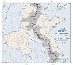
Figure 1 Visualization map of the main route of the Beijing-Hangzhou
Grand Canal
|
Table 1 Length of the main route of the Beijing-Hangzhou Grand Canal by
province
|
Province/
municipality
|
City
|
County
/District
|
Length
(km)
|
|
Beijing
|
|
Tongzhou
|
41.75
|
|
Hebei
|
Langfang, Cangzhou, Hengshui, Xingtai
|
Xianghe, Qingxian, Cangxian, Yunhe, Xinhua, Botou, Nanpi, Dongguang,
Wuqiao, Fucheng, Jingxian, Gucheng, Qinghe, Linxi
|
369.56
(the length shared with Shandong Province is 137.39)
|
|
Tianjin
|
|
Wuqing, Beichen, Hongqiao, Hebei, Nankai, Xiqing, Jinghai
|
175.87
|
|
Shandong
|
Dezhou, Liaocheng, Tai’an, Jining, Zaozhuang
|
Decheng, Wucheng, Xiajin, Linqing, Chiping, Dongchangfu, Yanggu,
Dongping, Liangshan, Jiaxiang, Wenshang, Rencheng, Shizhong (Jining),
Weishan, Taierzhuang, Yicheng
|
565.36
(the length shared with Hebei Province is 137.39)
|
|
Jiangsu
|
Xuzhou, Suqian, Huai’an, Yangzhou, Zhenjiang,
Changzhou, Wuxi, Suzhou
|
Tongshan, Jiuli, Gulou, Jiawang, Pizhou, Suyu, Sucheng, Siyang,
Huaiyin, Qinghe, Qingpu, Chuzhou, Baoying, Gaoyou, Jiangdu, Hanjiang,
Weiyang, Guangling, Jingkou, Dantu, Danyang, Wujin, Xinbei, Zhonglou, Tianning,Qishuyan,
Huishan, Beitang, Nanchang, Binhu, Xiangcheng, Huqiu, Jinchang, Canglang,
Wuzhong, Wujiang
|
632.83
|
|
Zhejiang
|
Jiaxing, Huzhou, Hangzhou
|
Xiuzhou, Nanhu, Tongxiang, Haining, Deqing, Yuhang, Gongshu, Xiacheng,
Jianggan
|
177.19
|
Note: Statistics are based
on the provincial/municipal, prefecture-level city, and district/county
administrative boundaries provided by the National Geomatics Center of China,
Ministry of Natural Resources.
References
[1]
Cheng, Y. H. The formation, development
and prosperity of the Grand Canal of China [J].
Journal of Liaocheng University (Social Science Edition), 2008(3): 1–7. DOI:
10.3969/j.issn.1672-1217.2008.03.001.
[2]
Wang,
C., Cao, L. Historical evolution and core value of cultural heritage of the
Beijing-Hangzhou Grand Canal [J]. People’s Tribune, 2019(30):
140–141.
[3]
China Academy of Cultural Heritage. The Grand Canal: a
living culture, a precious heritage [J]. Qiushi, 2025(1): 74–78.
[4]
Cui,
Z. P. Water Conservancy Encyclopedia China [M]. Beijing: China Water &
Power Press, 1991.
[5]
Origin of the Beijing-Hangzhou Grand Canal [EB].
China.org.cn. (2019-10-10) [2026-06-23]. http://yunhe.china.com.cn/2019-10/10/content_40910393.htm.
[6]
Liu, S. L., Huang, Q. Q. The Grand Canal extends ten thousand
Li, connecting rivers and seas; the nine provinces span vast heaven and earth [N/OL]. Guangming Daily. (2022-05-07)
[2026-06-23].
https://epaper.gmw.cn/gmrb/html/2022-05/07/nw.D110000gmrb_20220507_1-12.htm#1.
[7]
Zhang,
N. Latest Measurement of the Length of the Beijing-Hangzhou Grand Canal [N/OL].
China Science Daily. (2012-09-11) [2026-06-23].
https://news.sciencenet.cn/sbhtmlnews/2012/9/263202.shtm?id=263202.
[8]
Liaocheng’s 7 canal heritage sites and sections inscribed
on the World Cultural Heritage List [EB/OL].(2014-06-23) [2026-07-02].
http://www.liaocheng.gov.cn/channel_t_156_11232/doc_6394826d5042a20a2c245550.html.
[9]
In 1960, Shandong dug a new river called the Beijing-Hangzhou
Canal, while the original canal from the Yuan Dynasty is called
the Small Canal [EB/OL]. (2022-06-07) [2026-07-02]. https://dyhyjy.yzu.edu.cn/info/1019/1941.htm.
[10]
Canal
in the lake [EB/OL]. (2013-08-09) [2026-07-02].
http://www.weishan.gov.cn/art/2013/8/9/art_23101_1084179.html.
[11]
East
and west routes of the Beijing-Hangzhou Canal in Jiangsu and Shandong (map)
[EB/OL]. (2013-01-25) [2026-07-02]. http://www.gctezw.com/Item/4427.aspx.
[12]
Suqian section of the Middle Canal (World Cultural
Heritage, Major Historical and Cultural Site Protected
at the National Level) [EB/OL]. (2018-05-15) [2026-07-02]. https://wgl.suqian.gov.cn/swhgd/lyjd/201805/791f17ce31524e488a0eec1647a87950.shtml.
[13]
Cultural, Historical and Literary Committee of Huai’an
City. Construction of the Grand Canal “Hundred-Mile Gallery” from the perspective of
cultural-tourism integration [EB/OL]. (2023-01-13) [2026-07-02].
https://zx.huaian.gov.cn/col/13974_376653/art/m/16725024/16735704420025UMVxpFa.html#1.
[14]
Huaiyang
Canal Huai’an section of the Grand Canal heritage river [N/OL]. Today Gongshu.
(2022-07-01) [2026-07-02]. https://gsb.qybk.cn/html/2026-08/21/node_1.htm?v=1.
[15]
Regulations on the protection of the Grand Canal
Cultural Heritage in Yangzhou [EB/OL]. (2024-07-29) [2026-07-02].
https://wl.yangzhou.gov.cn/jgdj/xxyd/art/2024/art_5a7ed2ba0ee346d3bd3cba59b701e938.html#1.
[16]
“The ancient canal tells stories of the new era” series:
Zhenjiang chapter [EB/OL]. CNR News. (2021-02-20)
[2026-07-02].
https://ent.cnr.cn/yunhe/dj/yh/20210220/t20210220_525417284.shtml.
[17]
The
canal in Changzhou has a long history and has undergone three changes [N/OL].
Changzhou Daily. (2018-02-09) [2026-07-02].
https://m.gmw.cn/baijia/2018-02/09/27645205.html#verision=b92173f0.
[18]
Wuxi
section of the Grand Canal | the thousand-mile canal, only this ring [EB/OL].
(2024-03-14) [2026-07-02].
https://baijiahao.baidu.com/s?id=1793465742110577435&wfr=spider&for=pc.
[19]
The
Suzhou section of the Grand Canal successfully inscribed on the World Cultural
Heritage List [EB/OL]. (2014-07-04) [2026-07-02].
https://wlt.jiangsu.gov.cn/art/2014/7/4/art_72623_8162316.html.
[20]
Jiaxing
Municipal People’s Government. The canal section of the Grand Canal in Jiaxing
[EB/OL].(2017-09-06) [2026-07-02]. https:v//www.jiaxing.gov.cn/art/2017/9/6/art_1536271_22023562.html.
[21] Countdown to the Grand Canal’s
World Heritage application [N/OL]. Zhejiang Daily. (2014-03-26) [2026-07-02].
https://zjrb.zjol.com.cn/html/2013-03/27/content_2067043.htm?div=-1.
[22]
Outlook Weekly: renewing the millennia-old Grand Canal
[N/OL]. Outlook Weekly. (2025-05-20)[2026-07-02]. https://www.henan.gov.cn/2025/05-20/3160136.html.
[23]
Tongzhou
confirmed as northern starting point of Beijing-Hangzhou Grand Canal, monument
erectedat confluence of five rivers [N/OL].
Beijing Daily. (2015-06-17) [2026-07-02]. https://www.chinanews.com.cn/cul/2015/06-17/7348930.shtml.