Dataset
Development of the Spatial Distribution of 180 Earthquake Emergency Shelters in
Beijing
Cheng, L.1*
Sheng, S. Q.2* Ma,
Y.1
Zhang, X.1
1. Northwest Normal University, Lanzhou
730070, China;
2. China
Agricultural University, Beijing 100083, China
Abstract:
Earthquake emergency shelters are a crucial component of the urban public
safety and emergency management system. They are closely linked to national
security and represent an integral part of comprehensive all-hazard emergency
management. During major sudden events dominated by earthquake disasters, these
evacuation sites play a critical role by providing early warning response,
disaster relief, rescue operations, and temporary accommodation. Their
functions help achieve the goals of safe evacuation, sheltering disaster
victims, and maintaining social stability. Based on the statistical information
of 180 earthquake emergency shelters released by the Beijing Emergency
Management Bureau, this study utilizes the geocoding interface of internet map
services to extract the geographic coordinates of each site and establish a
spatial distribution dataset of earthquake emergency shelters in Beijing. The
dataset includes information such as the name, type, address, XY coordinates,
and total area of each site. It is archived in .shp
and .xls formats, comprising 9 data files with a
total data volume of 333 KB (compressed into 1 file of 47.9 KB).
Keywords: earthquake emergency shelter; comprehensive disaster
prevention; spatial point; Beijing
DOI: https://doi.org/10.3974/geodp.2025.04.06
Dataset Availability Statement:
The dataset supporting this paper
was published and is accessible through the Digital Journal of Global Change Data Repository
at: https://doi.org/10.3974/geodb.2025.08.04.V1.
1 Introduction
Urban
land is fundamental to city development and serves as the essential basis for
production and livelihoods in cities. With rapid population growth and
increasing urban migration, challenges related to employment, housing,
infrastructure, and environmental safety have become more pronounced. In this
context, developing scientific and effective urban planning and land management
strategies has become essential for achieving sustainable socio-economic
development and advancing the construction of resilient cities[1].
Although urban areas occupy less than 1% of the world’s land surface, they
generate 75% of the global GDP and consume 60%–80% of global energy.
Recognizing these dynamics, the United Nations released “Transforming our
world: the 2030 agenda for sustainable development” in 2015, which outlines 17
sustainable development goals (SDGs) and 169 specific targets encompassing
economic, social, and environmental dimensions. Among these, “Build resilient,
inclusive, safe, and sustainable cities and human settlements” (SDG 11) is
considered a key driver for achieving all other SDGs[2].
Rapid urbanization also poses significant challenges to urban disaster response
capabilities, making the construction of sustainable and resilient cities and
communities a vital area of research in disaster prevention and mitigation[3,4].
China’s government
has placed great emphasis on emergency management[5].
As the capital of China, Beijing holds significant domestic and international
influence. Covering a total area of 16,410.54 km2 and governing 16
districts, the city’s permanent population reached 21.858 million in 2023, with
an annual regional GDP of 4.376,07 trillion CNY, making it a representative
megacity. Historically, the Beijing Region has experienced nearly 200
earthquakes of magnitude 4.0 or higher, including 1 reaching magnitude 8.0. In
2003, China’s first emergency shelter was established at the Yuan Dadu City
Wall Ruins Park in Beijing, fully demonstrating the city’s exemplary role in
emergency shelter construction. Given equivalent seismic impacts, Beijing’s
demand for emergency shelter resources is particularly pressing[6].
To promote the
construction of resilient cities, the Beijing government issued the “Guidance
on accelerating resilient city construction” in 2021. The document emphasizes
that building resilient cities is essential for ensuring urban safety and
sustainable development. It explicitly calls for systematic planning and the
coordinated advancement of comprehensive emergency shelters, recognizing them
as a core element of the public safety system. These shelters are indispensable
for addressing all-hazard scenarios and play a key role in early warning,
emergency response, rescue, and transitional resettlement. Therefore, their
scientific and rational planning and construction are of utmost importance.
Promoting resilient city construction is essential to meeting the disaster
prevention needs of megacities and achieving high-quality, safe, and
sustainable development.
Currently, Beijing
has a total of 180 earthquake emergency shelters, classified into 3 categories
based on their configuration standards and capacity. Type I shelters (14 in
total) are fully equipped and can accommodate evacuees for more than 30 days.
Type II shelters (77 in total) are standardly equipped and can provide
accommodation for 10 to 30 days, while Type III shelters (89 in total) are
minimally equipped and can accommodate evacuees for up to 10 days. These
shelters encompass various types of facilities, including parks (excluding zoos
and protected cultural heritage sites), green spaces, squares, stadiums, and
other municipal public infrastructures.
As the economy and
society continue to develop, ensuring a corresponding level of security has
become a key objective in modern urban governance. Strengthening urban
resilience, enhancing self-adaptive capacity, and improving risk prevention
preparedness have given new significance to emergency shelter planning and
management[7]. At the same time, societal demand for emergency
shelter capacity continues to grow[8]. To address these needs, this
dataset provides spatial point information for 180 earthquake emergency
shelters in Beijing (2021–2025), including detailed data such as shelter
categories, administrative divisions, and spatial scope definitions. The
dataset offers essential support for studying the spatial distribution and
service efficiency of Beijing’s earthquake emergency shelters. Moreover, this
dataset holds substantial value for optimizing the spatial layout of emergency
shelters, promoting the integration of peacetime and disaster prevention
measures within comprehensive urban disaster prevention systems, and advancing
high-quality and safe urban development.
2 Metadata of the Dataset
The metadata of Spatial distribution dataset of
180 earthquake emergency shelters in Beijing[9] is summarized in Table 1. It includes the dataset full name, short
name, authors, year of the dataset, data format, data size, data files, data
publisher, etc.
Table 1 Metadata summary of the Spatial
distribution dataset of 180 earthquake emergency shelters in Beijing
|
Items
|
Description
|
|
Dataset full name
|
Spatial distribution
dataset of 180 earthquake emergency shelters in Beijing
|
|
Dataset short name
|
BeijingEES180
|
|
Authors
|
Cheng, L., School of Geography
and Environmental Sciences, Northwest Normal University, colgate77@163.com
Sheng, S. Q., School of Land
Science and Technology, China Agricultural University, shengsq@cau.edu.cn
Ma, Y., School of Geography and
Environmental Sciences, Northwest Normal University, Myue_0321@163.com
Zhang, X., School of Geography
and Environmental Sciences, Northwest Normal University, Zhxuan9106@163.com
|
|
Geographical region
|
Beijing (16
districts)
|
|
Year
|
2021–2025
|
|
Data format
|
.shp,
.xls
|
|
Data size
|
333 KB
|
|
Data files
|
Information on the
name, scope or address, type, and total area of each shelter
|
|
Foundations
|
National Natural
Science Foundation of China (42061054, 41561110)
|
|
Data publisher
|
Global Change
Research Data Publishing & Repository, http://www.geodoi.ac.cn
|
|
Address
|
No. 11A, Datun Road, Chaoyang District, Beijing 100101, China
|
|
Data sharing policy
|
(1) Data are openly
available and can be free downloaded via the Internet; (2) End users are
encouraged to use Data subject to citation; (3) Users, who are by
definition also value-added service providers, are welcome to redistribute Data
subject to written permission from the GCdataPR
Editorial Office and the issuance of a Data redistribution license;
and (4) If Data are used to compile new datasets, the “ten percent
principal” should be followed such that Data records utilized should
not surpass 10% of the new dataset contents, while sources should be clearly
noted in suitable places in the new dataset[10]
|
|
Communication and
searchable system
|
DOI, CSTR, Crossref,
DCI, CSCD, CNKI, SciEngine, WDS, GEOSS, PubScholar, CKRSC
|
3 Methods
3.1 Research Area
Beijing (115°25′00″E–117°30′00″E,
39°26′00″N–41°03′00″N) is located in the northern part of China, bordering
Tianjin to the east and Hebei Province on all other sides. The city administers
16 districts with a total area of 16,410.54 km2. The geographical
center of the municipality is situated in Xingshou
Town, Changping District, at approximately 40°15′02.1″N, 116°27′45.4″E. The
topography of Beijing is characterized by distinctly higher elevations in the
northwest and lower elevations in the southeast. The western, northern, and
northeastern parts of the city are surrounded by mountains, while the
southeastern area consists of a gently sloping plain that opens toward the
Bohai Sea. Mountainous regions account for about 61% of the city’s total area.
This geographical configuration gives Beijing a typical warm temperate
semi-humid continental monsoon climate, with 4 distinct seasons: cold, dry
winters, hot, rainy summers, and short, transitional spring and autumn periods.
The multi-year average annual rainfall is 585 mm. Major rivers within the
municipality include the Yongding River, Chaobai
River, Beiyun River, and Juma River, all of which
play vital roles in Beijing’s ecosystem and water resource management.
3.2 Methods
This
study collected statistical information on earthquake emergency shelters in
Beijing and compiled zonal statistics for all 16 districts. Using the geocoding
interface of an internet map service, the administrative divisions and
geographic coordinates of each earthquake emergency shelter were extracted,
after which the longitude and latitude data were added to the original
information table. With the support of ArcGIS 10.8, the spatial distribution of
earthquake emergency shelters in Beijing was visualized, and their spatial
distribution characteristics were analyzed in detail.
3.2.1 Data Sources
The
statistical information on earthquake emergency shelters in Beijing was
obtained from relevant notices issued by the Beijing Emergency Management
Bureau[11]. These data include information such as the location,
name, address, type, and total area of each shelter. The coordinate data for
the shelters were collected through the address service of the Amap platform[12], and the precise coordinates
were obtained using coordinate conversion tools.
3.2.2 Data Processing
(1)
Coordinate acquisition
The statistical
information table of earthquake emergency shelters published on the official
website of the Beijing Emergency Management Bureau does not include geographic
coordinates. Therefore, the Amap location service (Amap Address Service/Amap
API)[12] was used to perform geocoding based on the names and
addresses of each emergency shelter to obtain their coordinates. The GCJ-02
coordinate system used by Amap was then converted to
the Krasovsky 1940 coordinate system using a coordinate conversion tool to
ensure data accuracy and consistency.
(2)
Supplementary zoning
Although the
original statistical table of earthquake emergency shelters in Beijing included
the addresses and administrative districts of each site, some information had
become outdated due to the time span between releases and changes in
administrative boundaries. To ensure data timeliness and accuracy, the latest
administrative division information was retrieved using the Amap
reverse geocoding interface, based on the updated location coordinates.
(3) Data storage
Based on the
obtained geographic coordinates of earthquake emergency shelters in Beijing and
the latest administrative division data, a spatial data file in .shp format was generated, while attribute information such
as the name, address, and type of each shelter was archived synchronously in the
.xls file to support further analysis. The names and
examples of each field are provided in Table 2.
Table 2 Dataset attributes
|
Article
|
Description
|
|
Serial Number
|
1, 2, 3, …, 180
|
|
Region
|
Dongcheng District, Xicheng
District, Changping District, …
|
|
Name
|
Huangchenggen Ruins Park, Longtan Park, Wanshou Park, …
|
|
Address
|
Located between Nanbei Heyan Street to the west and Chengguang
Street to the east, …
|
|
Type
|
Ⅰ, Ⅱ, Ⅲ
|
4 Data Results
4.1 Dataset Composition
The Spatial distribution dataset of 180
earthquake emergency shelters in Beijing consists of 2 components: (1) vector
data of emergency shelter locations (.shp), and (2)
attribute data of the shelters, including name, address, type, total area, and
administrative division (.xls).
4.2 Data Results
The 180 earthquake emergency shelters are
distributed across all 16 districts of Beijing, with notable differences in
shelter numbers among districts (Figure 1). Daxing District has the highest
number, with 39 shelters, accounting for 21.7% of the city’s total. This number
not only far exceeds that of other districts but also surpasses the combined
total of the 8 districts with the fewest shelters. The remaining distribution
is as follows: 23 in Haidian District, 20 in
Changping District, 18 in Chaoyang District, 14 in Fangshan
District, 12 in Dongcheng District, 10 in Tongzhou District,10 in Xicheng District,
8 in Mentougou District, 5 in Shijingshan District, 5 in Pinggu District, 5
in Fengtai District, 4 in Yanqing District, 3 in
Miyun District, 2 in Huairou District,
and 2 in Shunyi District. This distribution
pattern indicates that Beijing’s emergency shelter planning carefully considers
differences in population density and emergency needs across the city’s various
regions.
The distribution
of earthquake emergency shelters in Beijing exhibits a clear clustering pattern
in the central urban area (Figure 2). Overall, the high-density areas (with a
maximum value of 0.216) for all three types of shelters are primarily
concentrated in the southeastern part of Haidian
District, the western part of Chaoyang District, Shijingshan
District, Xicheng District, Dongcheng District, and
the eastern part of Fengtai District. This
distribution pattern demonstrates a pronounced concentration in the southern
and central urban areas, with relatively sparse coverage toward the northern
and outer suburban districts.
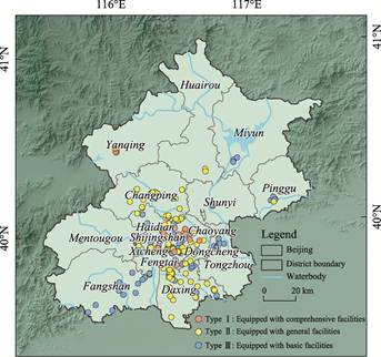
Figure 1 Spatial distribution map
of the earthquake emergency shelters across Beijing
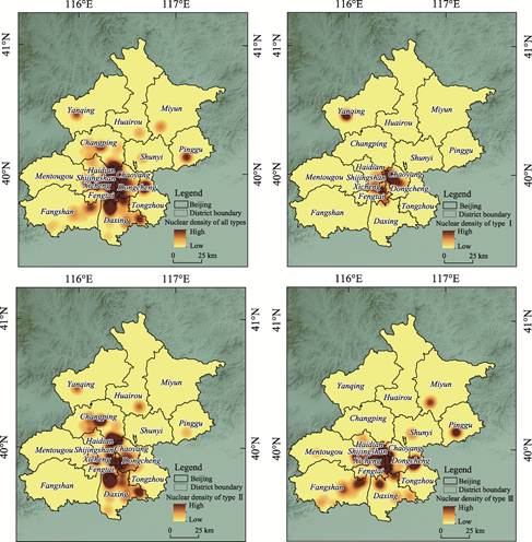
Figure 2 Maps of the kernel density of earthquake
emergency shelters in Beijing
Typological
analysis revealed that the high kernel density areas of Type I earthquake
emergency shelters (maximum value: 0.049) are concentrated in Chaoyang
District, Xicheng District, Dongcheng District, and
the western part of Yanqing District. For Type II shelters (maximum value:
0.146), the high-density areas are located in Xicheng District, Dongcheng District, eastern Shijingshan
District, northern Daxing District, and central Changping District. The
high-density areas of Type III shelters (maximum value: 0.146) are primarily
distributed in Xicheng District, Dongcheng District,
eastern Shijingshan District, northern Daxing
District, eastern Fangshan District, northern Tongzhou District, and southern Pinggu
District.
5 Discussion and Conclusion
Optimizing
the spatial layout of earthquake emergency shelters is a critical step in
enhancing urban resilience and public safety. This dataset provides detailed
information on 180 earthquake emergency shelters in Beijing (2021–2025)
released by the Beijing Municipal Emergency Management Bureau, covering
attribute data such as serial number, name, type, era, and address, as well as
spatial data including geographic coordinates and administrative divisions of
each shelter. The dataset is intended to support in-depth pattern discovery and
refined analysis in the field of urban comprehensive disaster prevention,
thereby fostering the integration of scientific research and practical
management. It provides essential data support for optimizing the spatial distribution
of shelters, improving urban emergency response capabilities, and strengthening
societal resilience in Beijing.
Analysis of this
dataset reveals significant spatial differentiation of earthquake emergency
shelters within the central urban area of Beijing. High-density service areas
are heavily clustered in the city’s core functional zones, resulting in an
overall imbalance in the shelter network. Peripheral areas, in contrast, often
experience poor accessibility, and in some cases, shelters may be entirely
unavailable.
Future planning of
earthquake emergency shelters should consider the existing distribution and
make better use of public spaces such as green areas, squares, and schools in
the central urban area to optimize or expand shelter facilities. Existing
shelters should be upgraded to better meet residents’ needs. Additionally,
planning should align with adjustments in the capital’s functional layout and
potential population relocations to alleviate pressure on shelters in the
central urban area and move toward a more balanced spatial distribution. At the
national level, spatial planning should combine spatial adaptability with a
high-level security and resilience framework, prioritize the safety needs of
residents, and promote coordinated urban development and protection. By
applying a sense of crisis and proactive planning, continuously improving urban
safety systems, and establishing a more efficient operational framework,
Beijing can better respond to complex risks and progress toward higher
resilience goals.
Despite the
comprehensive information provided by this dataset, it has considerable
potential for further development and data mining. Future improvements could
include 3 main aspects: at the basic data level, establishing standardized
cleaning processes to denoise, complete, and unify existing data formats, and
integrating IoT devices to collect real-time dynamic data such as environmental
conditions and traffic. At the scientific discovery level, collaboration with
research institutions could embed disaster warning models and AI algorithms,
improving prediction accuracy through machine learning-based data association
mining. At the level of social sustainable development, integrating community
feedback, economic indicators, and other data could support the construction of
a multidimensional evaluation system to quantify the impact of policies on
safety and the environment.
Author Contributions
Cheng, L. was responsible
for the overall design of the study; Cheng, L., Sheng, S. Q. and Ma, Y.
designed the methodology; Zhang, X., Ma, Y. and Cheng, L. conducted software
implementation; Ma, Y., Zhang, X. and Cheng, L. performed formal analysis; Zhang,
X. and Ma, Y. carried out the investigation; Ma, Y., Zhang, X. and Sheng, S. Q.
were responsible for data curation; Sheng, S. Q. and Cheng, L. wrote the
original draft; Cheng, L. reviewed and edited the manuscript; Ma, Y. and Zhang,
X. completed the visualization. All authors have reviewed the paper.
Conflicts of Interest
The
authors declare no conflicts of interest.
References
[1]
Sheng, S. Q., Song, W., Lian,
H., et al. Review of urban land management based on bibliometrics [J]. Land, 2022, 11(11), 1968.
[2]
Huang, C. L., Sun, Z. C., Jiang,
H. P., et al. Big Earth data supporting the realization of “Sustainable
Cities and Communities”: progress and challenges [J]. Bulletin of Chinese Academy
of Sciences, 2021, 36(8), 914–922.
[3]
Liu, C., Guo, H. D., Lv, T. T., et al. Development of the Haiti
earthquake (2010) rapid remote sensing analysis report dataset for the United
Nations [J]. Journal of Global Change
Data & Discovery, 2017, 1(2), 196–202. https://doi.org/10.3974/geodp.2017.02.10.
[4]
Lv, T. T., Liu, C., Zhao, J. L., et al. Landslide location and
type dataset triggered by the 2010 Haiti earthquake in the Flos River Basin [J].
Journal of Global Change Data & Discovery, 2017, 1(2), 188–195.
https://doi.org/10.3974/geodp.2017.02.09.
[5]
Department of Earthquake and
Geological Disaster Rescue, Ministry of Emergency Management. Promoting the
high-quality construction of emergency shelters to provide high-level safety
protection for the people [J]. China
Disaster Reduction, 2024, (13), 8–11.
[6]
You, D., Wang, S. X., Wang, F. T.,
et al. Evaluation of the carrying capacity of emergency shelters in
Beijing based on the AHP-EWM multi-objective decision-making model [J]. Journal of Remote Sensing, 2024, 28(9),
2276–2292.
[7]
Gao, L. J., Yang, L. Beijing: enhancing
urban resilience and promoting the construction of emergency shelters [J]. China Disaster Reduction, 2024, (13),
16–17.
[8]
Zhang, J., Li, L. Promoting
modern urban governance through resilient and safe city development [J]. Seek Truth, 2024(9), 34–36.
[9]
Cheng, L., Sheng, S. Q., Ma, Y.,
et al. Spatial distribution dataset of 180 earthquake emergency shelters
in Beijing [J/DB/OL]. Digital Journal of Global Change Data Repository,
2025. https://doi.org/10.3974/geodb. 2025.08.04.V1.
[10]
GCdataPR Editorial Office. GCdataPR data sharing
policy [OL]. https://doi.org/10.3974/dp.policy.2014.05 (Updated 2017).
[11]
Beijing earthquake emergency
shelter information [EB/OL]. (2024-05-15) [2024-11-05]. https://yjglj. beijing.gov.cn/.
[12]
Amap open platform service agreement [EB/OL]. (2024-10-21) [2024-11-05].
https://developer.amap.com/ product/smart-address.