Dataset
Development on the Distribution of Large and Medium Hydropower Stations across
the Qinghai-Xizang Plateau (2024)
Huang, Y. F.1,2
Yang, L. H.1,4*
Song, X. F.1,4
Zhang, X. Z.1,3
1. Key
Laboratory of Water Cycle & Related Land Surface Process, Institute of
Geographic Sciences and Natural Resources Research, Chinese Academy of
Sciences, Beijing 100101, China;
2. Sino-Danish College of University of Chinese
Academy of Sciences, Beijing 100049, China;
3. School
of Air Transportation / Flight Academy, Shanghai University of Engineering
Science, Shanghai 201620, China;
4. Technical
Innovation Base for Natural Resources Monitoring in the Lower Reaches of
Yongding River Area, China Geological Society, Langfang 065000, China
Abstract:
As a crucial ecological barrier and a major hydropower energy base in China,
hydropower development on the Qinghai-Xizang Plateau exerts a profound
influence on the regional ecological environment. To support the evaluation of
ecological effects of major construction projects under the Second
Comprehensive Scientific Expedition to the Qinghai- Xizang Plateau, this study
systematically collected and organized data on large and medium-sized
hydropower stations that have been built or are currently under construction
across the plateau. The dataset encompasses 61 hydropower stations distributed
across 6 major river basins—the Yarlung Zangbo River, Yellow River, Jinsha River, Lancang River,
Yalong River, and Min River—and includes key attributes such as station name,
geographical location, total reservoir capacity, installed capacity, annual
power generation, regulation performance, development mode, and construction
period. The data sources consist of field surveys and literature review. There
was a “dense in the east and sparse in the west” spatial pattern of the large
and medium-sized hydropower stations on the Qinghai-Xizang Plateau. Significant
inter-basin differences were observed in both installed capacity and reservoir
scale. Although the pace of hydropower construction has slowed, the scale of
individual projects has increased, and dam-type development remains
predominant. This dataset provides a solid scientific foundation for assessing
ecological impacts of hydropower projects, managing regional water resources,
and planning energy systems under the goal of carbon neutrality.
Keywords: Qinghai-Xizang Plateau; large and medium-sized
hydropower station; installed capacity; spatial distribution
DOI: https://doi.org/10.3974/geodp.2025.04.02
1 Introduction
The
Qinghai-Xizang Plateau plays a crucial role in shaping and regulating China’s
climate system[1–6]. Clarifying
the impacts and potential ecological risks of major hydropower development
projects on the Plateau’s ecological security barrier system is fundamental for
strengthening ecological protection and taking corresponding preventive
measures. According to the objectives of the Second Comprehensive Scientific
Expedition to the Qinghai-Xizang Plateau, under the theme “Ecological and
Environmental Effects of Major Construction Projects”, it has become an urgent
need to conduct scientific evaluations of the ecological and environmental
effects of large-scale hydropower development projects on the Qinghai-Xizang
Plateau. However, existing hydropower project data are fragmented, unsystematic,
and lack key parameters necessary for ecological effect assessment.
This study,
based on the task framework of the above scientific expedition, adopts a
combined approach of field investigation and literature collection to
systematically gather and organize multi-dimensional attribute data for 61
large and medium-sized hydropower stations distributed across the 6 major
basins of the Qinghai-Xizang Plateau.
This work fills
the data gap in the hydropower engineering system of the Qinghai-Xizang Plateau
and supports the needs of the Second Comprehensive Scientific Expedition. In
the future, this dataset can further serve regional water resource management
and energy planning under the carbon neutrality target, providing a scientific
foundation for sustainable regional development and policy decision-making.
2 Data Sources and Methods
This
study is based on the objectives of the Second Comprehensive Scientific
Expedition to the Qinghai-Xizang Plateau, under the theme “Ecological and
Environmental Effects of Major Construction Projects”. It follows the standards
specified in the Classification and design safety standards for hydropower projects
(DL 5180—2003)[7]. A total of 61
large and medium-sized hydropower stations (each with an installed capacity ≥ 50,000
kW) that have been built or are under construction across the 6 major river
basins of the Qinghai-Xizang Plateau were systematically investigated and
documented. Data collection was carried out through 2 complementary approaches:
(1) Field investigation—using GPS positioning (accuracy±10 m) and on-site
institutional visits to obtain first-hand data such as geographical location,
construction status, and engineering scale of hydropower stations; (2)
Engineering literature review—supplementing technical parameters by referencing
journal articles and published materials[8–17].
Data quality control was ensured through multi-source cross-validation (e.g.,
comparing enterprise data with government bulletins) and spatial verification
(using coordinate pickers from the Gaode Map Open
Platform). The dataset was organized into 6 sub-tables corresponding to the 6 river
basins, encompassing 12 core indicators, including the station name, installed
capacity, and regulation performance. Owing to the expedition’s route, data on
large and medium hydropower stations in the Yarlung Zangbo River, Yellow River, Lancang River, Yalong River,
and Min River basins came from firsthand visits by authors. Data for the Jinsha
River basin were collected from academic journals.
In terms of data
development, this study standardized all key fields, including the station
name, river basin, administrative division, installed capacity, total reservoir
capacity, regulation performance, and development mode. Logical consistency
tests were performed on indicators such as the construction year, installed
capacity, and reservoir capacity, and all outliers and duplicate records were
removed. Based on the QGIS platform, the geographical coordinates of each
hydropower station were converted into spatial point vector data, and spatial
partitioning was conducted according to the 6 major river basins for regional
management and analysis.
3 Data Results
3.1 Dataset Composition
The
Dataset on the distribution of large and medium hydropower stations across the
Qinghai-Xizang Plateau (2024) consists of 6 parts, corresponding to the 6 major
river basins: the Yarlung Zangbo
River, Yellow River, Jinsha River, Lancang River, Yalong River, and Min River.
Each sub-dataset includes detailed records of the large and medium-sized
hydropower stations that have been built or are under construction within the
respective basin.
3.2 Data Results
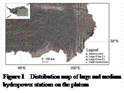 From the perspective of
spatial distribution, the 61 large and medium-sized hydropower stations exhibit
a significant spatial imbalance (Figure 1), with the characteristic pattern of
being “dense in the east and sparse in the west”. Most stations were
concentrated in the southeastern region of the plateau. Among them, the Min
River Basin contained the largest number of hydropower stations (20 in total),
accounting for 32.8% of all stations, while the Jinsha River Basin had the
highest number of stations under construction (6 in total), representing 54.5%
of all ongoing projects.
From the perspective of
spatial distribution, the 61 large and medium-sized hydropower stations exhibit
a significant spatial imbalance (Figure 1), with the characteristic pattern of
being “dense in the east and sparse in the west”. Most stations were
concentrated in the southeastern region of the plateau. Among them, the Min
River Basin contained the largest number of hydropower stations (20 in total),
accounting for 32.8% of all stations, while the Jinsha River Basin had the
highest number of stations under construction (6 in total), representing 54.5%
of all ongoing projects.
In terms of
elevation gradient, large and medium-sized hydropower stations were mainly
concentrated within 1,000–4,000 m, which aligned closely with the topographic
characteristics of the deep canyon regions of the plateau. These canyons,
characterized by fast-flowing rivers and abundant hydropower potential, provide
favorable natural conditions for hydropower development. The 11 projects
currently under construction were extending into remote areas such as the upper
reaches of the Jinsha River, reflecting a relationship between the development
sequencing and project accessibility: earlier developments prioritized areas
with convenient transportation, while later phases gradually expanded into more
remote regions—an indication of technological advancement and growing energy
demand.
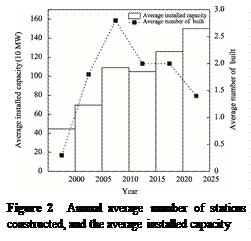
Time series
analysis shows that the period 2005–2010 marked the first major peak in
hydropower construction on the Qinghai-Xizang Plateau, with an average annual
increase of 2.8 large and medium-sized stations, and a record high of 8 new
stations in 2006. During this period, strong policy support attracted
substantial capital and technological investments, driving rapid growth in
hydropower construction. After 2010, the pace of new construction slowed, but
the scale of individual projects increased. For example, the Lianghekou Hydropower Station, which began construction in
2015, had a reservoir capacity of 12 billion m3. This change
reflects both the maturity of large-scale project conditions and the growing need for enhanced water regulation to
improve resource utilization efficiency and meet broader energy demands. The
average installed capacity of hydropower stations rose from 698,200 kW during 2000–2005 to 1,260,500 kW
during 2020–2025 (Figure 2), demonstrating significant improvement in
hydropower technology and engineering capability.
 In terms of regulation type,
daily regulated stations accounted for 64.3% (36 stations), indicating that
most facilities were designed primarily to handle short-term peak-load
demands, with limited ability to regulate intra-annual runoff distribution.
Regarding development mode, dam-type projects made up 50.8% (31 stations),
slightly higher than diversion-type projects (47.5%, 29 stations), with only 1
pumped-storage station recorded. This distribution pattern reflects the
geographical and engineering characteristics of hydropower development on the Qinghai-Xizang
Plateau: the canyon terrain is favorable for intercepting river flow and
forming large reservoir capacities, which facilitates water regulation and
power generation. In contrast, diversion-type development harnessed the river’s
potential energy drop for power generation, minimizing large-scale inundation
and thereby reducing ecological impact—an approach particularly significant for
the fragile ecological environment of Qinghai-Xizang Region.
In terms of regulation type,
daily regulated stations accounted for 64.3% (36 stations), indicating that
most facilities were designed primarily to handle short-term peak-load
demands, with limited ability to regulate intra-annual runoff distribution.
Regarding development mode, dam-type projects made up 50.8% (31 stations),
slightly higher than diversion-type projects (47.5%, 29 stations), with only 1
pumped-storage station recorded. This distribution pattern reflects the
geographical and engineering characteristics of hydropower development on the Qinghai-Xizang
Plateau: the canyon terrain is favorable for intercepting river flow and
forming large reservoir capacities, which facilitates water regulation and
power generation. In contrast, diversion-type development harnessed the river’s
potential energy drop for power generation, minimizing large-scale inundation
and thereby reducing ecological impact—an approach particularly significant for
the fragile ecological environment of Qinghai-Xizang Region.
Overall, China’s
hydropower development on the Qinghai-Xizang Plateau has achieved remarkable
progress, forming a regionally distinctive hydropower development pattern.
Through the rational planning and coordinated development of various river
basins, the major hydropower projects in the region have made substantial
contributions to the national energy supply, while optimizing the use of the plateau’s
rich hydropower resources.
4 Discussion and Conclusion
The
Dataset on the distribution of large and medium hydropower stations across the
Qinghai-Xizang Plateau (2024) systematically integrates the core attribute
information of 61 large and medium-sized hydropower stations distributed across
the 6 major river basins. This dataset directly supports the Second
Comprehensive Scientific Expedition to the Qinghai-Xizang Plateau, particularly
the research theme “Ecological and Environmental Effects of Major Construction
Projects”.
The results
revealed a clear spatial pattern of “dense in the east and sparse in the west”
with hydropower stations mainly concentrated within the 1,000–4,000 m. In
temporal terms, the period 2005–2010 marked a construction boom, followed by a
slowdown in new projects but a steady increase in the scale of individual
stations. The average installed capacity rose from 698,200 kW in 2000–2005 to
1,260,500 kW in 2020–2025, reflecting continuous technological advancement and
optimization in hydropower engineering.
Regarding
regulation performance daily regulated stations dominated the dataset,
indicating that many facilities are still focused on short-term peak demand
adjustments. In terms of development mode, dam-type hydropower stations
slightly outnumbered diversion-type stations, illustrating the continued
importance of reservoir-based hydropower for resource regulation and energy
supply stability.
Overall, this
dataset provides a comprehensive and reliable record of the spatial
distribution, scale characteristics, and construction timelines of large and
medium-sized hydropower stations built and under construction on the Qinghai-Xizang
Plateau. It lays a solid data foundation for advancing understanding of the
current status and future trends of hydropower development, facilitating
scientific evaluation of its ecological impacts, and supporting the formulation
of sustainable strategies for regional water resource and energy management
under the national carbon neutrality goals.
Author Contributions
Huang, Y. F. was
responsible for the overall design and development of the dataset and authored
the data paper. Zhang, X. Z. participated in data collection and processing.
Yang, L. H. and Song, X. F. revised and refined both the dataset and the data
paper.
Conflicts of Interest
The
authors declare no conflicts of interest.
References
[1]
Wu,
S. H., Yin, Y. H., Zheng, D., et al. Climate
changes in the Qinghai-Xizang Plateau during the last three decades [J]. Acta
Geographica Sinica, 2005(1): 3–11.
[2]
Wu,
F. L., Fang, X. M., Yang, Y. B., et al. Reorganization
of Asian climate in relation to Tibetan Plateau uplift [J]. Nature Reviews Earth & Environment, 2022,
3: 684–700.
[3]
Yao,
T. D., Chen, F. H., Cui, P., et al. From Qinghai-Xizang
Plateau to Third Pole and Pan-Third Pole [J]. Bulletin of Chinese Academy of
Sciences, 2017, 32(9): 924–931.
[4]
Xu, X. D., Dong, L. L., Zhao,
Y., et al. Effect of the Asian Water Tower over the Qinghai-Xizang
Plateau and the characteristics of atmospheric water circulation [J]. Chinese
Science Bulletin, 2019, 64(27): 2830– 2841.
[5]
Piao,
S. L., Zhang, X. Z., Wang, T., et al. Responses
and feedback of the Qinghai-Xizang Plateau’s alpine ecosystem to climate change
[J]. Chinese Science Bulletin, 2019, 64(27): 2842–2855.
[6]
Yao,
T. D., Wu, G. J., Xu, B. Q., et al. Asian Water
Tower change and its impacts [J]. Bulletin of Chinese Academy of Sciences,
2019, 34(11): 1203–1209.
[7]
State Economic and Trade
Commission of P. R. China. Classification and design safety standards for
hydropower projects (DL 5180—2003) [S]. Beijing: China Electric Power Press,
2003.
[8]
Lei, B. T., Zheng, F. G. General
layout design of Boluo Hydropower Station in the upper
reach of Jinsha River [J]. Design of Hydroelectric Power Station, 2025,
41(1): 35–38.
[9]
Lin, C. Y., Li, J. M. Key
difficulties and countermeasures for resettlement of YBT Hydropower Station in
the upper reaches of Jinsha River [J]. Technical Supervision in Water
Resources, 2025, 2(2): 80–82.
[10]
Lian, X. J., Li, H. L. Scheme
and fulfillment of river closure in Lawa Hydropower Station [J]. Sichuan
Hydro Power, 2022, 41(3): 55–59.
[11]
Zhang,
W. B., Li, J., Bi, X. J., et al. Research on the
reservoir initial impoundment plan of the Batang Hydropower
Station in the upstream of the Jinsha River [J]. Sichuan Hydro Power,
2024, 43(3): 141–144.
[12]
Chen,
J. Y., Sun, T. T., Li, H. T., et al. Phytoplankton
community structure and water quality status in upper reaches of Jinsha River
affected by constructing Suwalong Hydropower Station [J].
Freshwater Fisheries, 2021, 51(2): 87–97.
[13]
Wen, H., Wang, M. Study on layout
of diversion underground powerhouse and switch station of Changbo
Hydropower Project [J]. Sichuan Hydro Power, 2024, 43(4): 101–106.
[14]
Wang,
X. M., Kong, F. H., Huang, H. F., et al. Study
on major technical issues in design of Xulong
Hydropower Station [J]. Yangtze River, 2024, 55(S2): 138–143.
[15]
Xu,
W., Ding, S. X., Chen, Y. C., et al. Ecological
operation experiment and effect analysis of Liyuan Hydropower Station in middle
reaches of Jinsha River [J]. Yangtze River, 2023, 54(9): 82–90.
[16] Zhang, Y. L., Liu, L. S., Li, B. Y., et
al. Boundary data of the Qinghai-Xizang Plateau (2021 Version)[J/DB/OL]. Digital Journal of Global Change Data
Repository, 2021. https://doi.org/10.3974/geodb.2021.07.10.V1.
[17]
Zhang,
Y. L., Liu, L. S., Li, B. Y., et al. Comparison
of boundary datasets covering Qinghai-Xizang Plateau between 2021 and 2014
versions [J]. Journal of Global Change Data & Discovery,
2021, 5(3): 322–332. https://doi.org/10.3974/geodp.2021.03.10.