Dataset Development of Potential Suitable Areas Estimation
for Barley Cultivation on the Qinghai- Xizang Plateau under Two Different
Climate Scenarios
WEI Ying1 LIU Xuan1 MA Weidong1,2* LIU Fenggui1,2 ZHOU Qiang1,2
CHEN Qiong1,2
1. School of Geographical Science & School of National
Safety and Emergency Management, Qinghai Normal University, Xining 810016,
China;
2. Research Center for Plateau Disaster Reduction and
Emergency Management, Institute of Plateau Science and Sustainable Development,
Beijing Normal University-Qinghai Provincial People’s Government, Xining
810016, China
Abstract: As climate change leads
to increased volatility and extremes, the vulnerability of agricultural
production on the Qinghai-Xizang Plateau has grown, making it necessary to
implement more scientific management and rational planning of agricultural
production on the plateau in order to enhance the ability to ensure food
security there. Based on the current status of highland barley cultivation on
the Qinghai-Xizang Plateau, the authors integrated multi-source data, including
Digital Elevation Models (DEM), soil parameter indices and eco-meteorological
variables, to simulate the current potential suitable areas for barley
cultivation. They also projected the potential suitable areas for highland
barley cultivation on the Qinghai-Xizang Plateau under RCP4.5 and RCP8.5
climate change scenarios for various future time periods. The results indicate
that from the present period (1970–2000) through the near-term future (2021–2040)
to the medium-term future (2041–2060), the area of regions unsuitable for potential
highland barley cultivation is gradually decreasing, whilst the area of regions
with medium and high suitability is gradually increasing; In both the near
future and the mid-long-future, the area of unsuitable zones under RCP8.5 is
smaller than that under RCP4.5, whilst the areas of moderate and high
suitability are larger than those under RCP4.5. The dataset includes: potential
suitable cultivation zones for highland barley in the current period, the
near-term future under RCP4.5, the near-term future under RCP8.5, the
medium-term future under RCP4.5, and the medium-term future under RCP8.5. The
spatial resolution is 2.5′x2.5′. The dataset is archived in .tif format, and consists
of 20 data files with data size of 6.27 MB (compressed into 1 file with 2.88
MB). This dataset supported the first author’s doctoral thesis in Science.
Keywords: highland barley, Qinghai-Xizang Plateau,
climate
change, potentially suitable area, MaxEnt model, doctoral thesis in Science
DOI: https://doi.org/10.3974/geodp.2026.04.05
Dataset Availability Statement:
The dataset supporting this paper
was published and is accessible through the Digital Journal of Global Change Data Repository
at: https://doi.org/10.3974/geodb.2026.04.06.V1.
1 Introduction
The
outline of the Intergovernmental Panel on Climate Change (IPCC) Seventh
Assessment Report clearly states that global climate risk assessments have
shifted from focusing on single physical variables to a comprehensive
integration of complex, compound, and cascading risks, with particular emphasis
on the key Earth system thresholds and abrupt changes (such as tipping-point
effects) may have potentially irreversible impacts on regional agricultural
production, food security, and ecosystem stability[1–3]. Global
warming is not merely a single environmental issue; it also triggers a series
of systemic social problems, with agricultural production being particularly
hard hit. The increasing frequency of natural disasters and extreme weather and
climate events in the context of climate change may exacerbate the crisis in an
already vulnerable agricultural sector, potentially posing a serious threat to
national food security in the future[4].
As the plateau
with the highest average elevation in the world, the Qinghai-Xizang Plateau has
a unique and complex climate; at the same time, agricultural production in this
region has already approached environmental limits along the vertical gradient.
Consequently, the impact of various natural disasters caused by extreme weather
and climate events on agriculture in this region is more pronounced than in
other areas. Currently, arable land resources in the Qinghai-Xizang plateau
region are extremely limited and of poor quality, making the contradiction
between growing food demand and limited supply capacity increasingly acute[5].
In such a harsh environment, the variety of food crops that can be cultivated
on the plateau is very limited; however, due to its cold and drought tolerance,
short growing season, and strong stress resistance, highland barley is
well-suited for cultivation on the Qinghai-Xizang Plateau[6,7].
Against the backdrop of current global climate change, it is particularly
important for the Qinghai-Xizang Plateau to scientifically manage and
rationally plan agricultural production using its limited arable land
resources. Therefore, this dataset estimates the potential suitable areas for
highland barley cultivation under different time periods and scenarios-both
currently and in the future-providing a data reference for the rational
development of highland barley cultivation on the Qinghai-Xizang plateau and
for understanding the distribution of reserve arable land resources.
This dataset
uses current data on the area under highland barley cultivation on the
Qinghai-Xizang Plateau to generate random highland barley sample points. Based
on the MaxEnt model and environmental variables affecting highland barley
cultivation, it estimates potential suitable areas for highland barley
cultivation in the current period, the near future, and the medium-term future,
in order to obtain spatial distribution data at the grid scale for suitable
highland barley cultivation areas[8].
2 Metadata of the Dataset
The metadata of the
Dataset of potential suitable areas estimation for barley cultivation on the
Qinghai-Xizang Plateau under two different climate scenarios[9] including the dataset name,
authors, geographic region, year of the dataset, data format, data size, data
files, data publisher, are summarized in Table 1.
Table 1 Metadata summary of the
Dataset of potential suitable areas estimation for barley cultivation on the
Qinghai-Xizang Plateau under two different climate scenarios
|
Items
|
Description
|
|
Dataset full name
|
Dataset of
potential suitable areas estimation for barley cultivation on the
Qinghai-Xizang Plateau under two different climate scenarios
|
|
Dataset short
name
|
P.SuitableArea_QZ_Plateau
|
|
Authors
|
Wei, Y., Qinghai Normal University, yingwei202509@163.com
Liu, X., Qinghai Normal University, 202547331003@stu.qhnu.edu.cn
Ma, W. D., Qinghai Normal University, mwd0910@sina.com
Liu, F. G., Qinghai Normal University, lfg_918@163.com
Zhou, Q., Qinghai Normal University, zhouqiang729@163.com
Chen, Q., Qinghai
Normal University, 2025055@qhnu.edu.cn
|
|
Geographical
region
|
Qinghai-Xizang
Plateau (approximately 25°N–40°N, 73°E–105°E)
|
|
Year
|
1970–2000; 2021–2040;
2041–2060
|
|
Spatial
resolution
|
2.5′×2.5′
|
|
Data format
|
.tif
|
|
|
|
Data size
|
6.27 MB
|
|
|
|
Data files
|
Current period
spatial distribution data of suitable areas for highland barley cultivation
on the Qinghai-Xizang Plateau; Near-term and medium-term spatial distribution
data of potential suitable areas for highland barley cultivation on the
Qinghai-Xizang Plateau (RCP4.5 scenario, RCP8.5 scenario)
|
|
Foundation
|
Ministry of
Science and Technology of P. R. China (2019QZKK0606)
|
|
Data publisher
|
Global Change Research Data Publishing & Repository,
http://www.geodoi.ac.cn
|
|
Address
|
No. 11A, Datun Road,
Chaoyang District, Beijing 100101, China
|
|
Data sharing
policy
|
(1) Data
are openly available and can be free downloaded via the Internet; (2) End
users are encouraged to use Data
subject to citation; (3) Users, who are by definition also value-added
service providers, are welcome to redistribute Data subject to written permission from the GCdataPR Editorial
Office and the issuance of a Data
redistribution license; and (4) If Data
are used to compile new datasets, the “ten percent principle” should be
followed such that Data records
utilized should not surpass 10% of the new dataset contents, while sources
should be clearly noted in suitable places in the new dataset[10]
|
|
Communication and searchable system
|
DOI, CSTR, Crossref, DCI, CSCD, CNKI, SciEngine, WDS, GEOSS, PubScholar,
CKRSC, OARL
|
3 Methods
Based
on the current status of highland barley cultivation on the Qinghai-Xizang
Plateau, the authors established a comprehensive dataset of highland barley
sampling points covering the entire region, identified key habitat variables
affecting highland barley cultivation, and used the MaxEnt model to simulate
potential suitable areas for highland barley cultivation under various
scenarios. To ensure the spatial continuity of potential suitable areas for
highland barley cultivation on the Qinghai-Xizang Plateau and to avoid a large
number of fragmented patches in the projected results, this dataset did not
exclude land use and land cover types where crop cultivation is impossible,
such as water bodies, glacial snow and ice, developed land, and bare ground. In
subsequent practical applications of the data, consideration may be given to
excluding unsuitable land categories based on actual regional conditions.
3.1 Data Sources
The steps for developing a dataset of potential
suitable areas for highland barley cultivation on the Qinghai-Xizang Plateau
under two different climate scenarios are as follows: (1) Based on
current data on highland barley cultivation areas on the Qinghai-Xizang
Plateau, 134,410 sample points were generated through relevant processing using
ArcGIS software. These points were then screened in stages according to the
IPCC’s definition of likelihood, ultimately identifying 3,066 barley sample
points; (2) For 42 habitat variables that could potentially influence the
potential suitability zones for highland barley cultivation, KL divergence
calculations were performed, contribution rates were ranked, and
multicollinearity was eliminated, ultimately selecting 10 habitat variables for
the MaxEnt model; (3) A MaxEnt model was constructed using the 3,066 sample
points, with 75% used for training the model to identify environments suitable
for barley growth and 25% for validation. By comparing AUC values, the model simulated
the current potential distribution area of highland barley and validated its
accuracy; (4) The distribution of potential suitable areas for highland barley
under different climate scenarios was projected. The specific workflow is shown
in Figure 1.
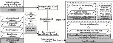
Figure 1 Flowchart of the dataset
development
3.2 Data Source
After
fully considering all factors affecting the natural suitability for highland
barley cultivation, the following data were selected for this study:
(1) The 42
environmental variables that may influence potential suitable areas for
highland barley cultivation include climate indicators, soil indicators,
elevation, slope, and solar radiation. The elevation data (2010, spatial
resolution of 30 m×30 m) were obtained from the United States Geological Survey; soil
parameter indices (2012, spatial resolution of 5′×5′) were obtained from the
Harmonized World Soil Database;
meteorological indicators and bioclimatic variables were obtained from the
World Clim database (Version 2.0),
where the baseline period for the current period is 1970–2000, and the
near-future and medium-term periods are 2021–2040 and 2041–2060, respectively. The dataset selected is RCP 4.5
(temperature increase of 1.0–2.6 ℃, CO2 concentration change of
650×10‒6 L/L, precipitation increase of 4.00%) and RCP 8.5
(temperature rise of 2.6–4.8 ℃, CO2 concentration change of
1,350×10‒6 L/L, precipitation increase of 4.60%) as representative
concentration pathways, with a spatial resolution of 2.5′×2.5′.
(2) Data on the
area under cultivation of highland barley on the Qinghai-Xizang Plateau (2019,
spatial resolution of 15 m×15 m) were used to construct a dataset of highland
barley cultivation sample points and were sourced from a dataset previously
developed by our team[11];
All of the above
data were masked and extracted according to the boundaries of the
Qinghai-Xizang Plateau as defined by ZHANG Yili, et al.[12,13],
thereby serving as the scope for estimating potential suitable areas for
highland barley cultivation.
3.3 Algorithm
The
representativeness of crop sampling sites and the volume of data, as well as
habitat variables that have a substantial impact on crops, are key
considerations when using the MaxEnt model to estimate potential suitable areas
for highland barley cultivation. Based on this, it is necessary to conduct a
dual screening of highland barley cultivation sites and the environmental
variables that influence highland barley cultivation.
3.3.1 Generation and Screening of Highland Barley Cultivation
Distribution Points
The
database of highland barley cultivation locations was created using 2019 data
on highland barley cultivation areas on the Qinghai-Xizang Plateau. After
performing operations such as “vector-to-raster conversion” and
“raster-to-point conversion” on the vector layers in ArcGIS software, a total
of 134,410 points were obtained. In accordance with the IPCC’s definition of
likelihood, the highland barley cultivation areas within the grid were divided
into 5 groups based on different area ranges. Subsequently, the number of
sample points to be selected from each group was determined according to a
specific proportion. Ultimately, 3,066 highland barley distribution points were
selected for inclusion in the model. For a detailed description of the
screening process, please refer to the relevant article associated with the
dataset[14].
3.2.2 Screening of Habitat Variables for MaxEnt Model
Based
on the number of sample points selected as described above, 42 environmental
variables that may influence the potential suitability zones for highland
barley cultivation were screened. The steps included: (1) Calculation of the KL
divergence, all variables with a KL divergence below 1 were eliminated, and the
remaining variables were retained for the next screening step. After
calculation, a total of 18 variables were selected; (2) Contribution rate
assessment, the remaining 18 habitat variables were input into the MaxEnt model
for a second round of screening to eliminate factors with insignificant
contribution rates; (3) Autocorrelation analysis of factors, a third round of
screening was conducted to avoid including highly correlated indicators in the
model, resulting in the retention of the remaining 10 variables, as shown in
Table 2.
Table 2
Final 10 habitat variables after screening
|
Variable name
|
Variable meaning
|
Contribution rate
|
Variable name
|
Variable meaning
|
Contribution rate
|
|
BIO1
|
Annual average
temperature
|
50.50%
|
BIO4
|
Seasonal temperature
|
1.70%
|
|
BIO12
|
Annual
precipitation
|
31.60%
|
BIO8
|
Average wet season temperature
|
1.30%
|
|
BIO9
|
Dry season average temperature
|
5.40%
|
SDTO
|
Gravel percentage
|
1.00%
|
|
BIO5
|
Warmest month’s
maximum temperature
|
4.70%
|
ORGC
|
Organic carbon content
|
1.00%
|
|
CECC
|
Cation exchange
capacity of clay fraction
|
2.50%
|
ECEC
|
Effective cation exchange capacity
|
0.30%
|
4 Data Results and Validation
4.1 Dataset Composition
The dataset includes: potential suitable
cultivation zones for highland barley in the current period, the near-term
future under RCP4.5, the near-term future under RCP8.5, the medium-term future
under RCP4.5, and the medium-term future under RCP8.5. The dataset is archived
in .tif format.
4.2 Accuracy Evaluation of MaxEnt Model Simulation Results
The
MaxEnt model integrates existing crop distribution data with grid-based
environmental gradient indicators to determine whether a region is suitable for
growing a particular crop. Using a quantification range of 0 to 1, this model
measures the similarity between the environmental conditions of different
regions and the habitat requirements of the target crop; it can predict the
potential distribution range of a species and also output corresponding
distribution probability estimates. The authors divided 3,066 highland barley
sample points into training and validation sets in a 75% to 25% ratio; the
corresponding AUC values were 0.888 and 0.885, indicating that the model has
high accuracy and can be used to predict potential suitable cultivation areas
for highland barley on the Qinghai-Xizang Plateau[14].
4.3 Validation of Preliminary Estimation Results
and Accuracy
4.3.1 Preliminary Estimated Results
Using
the suitability index (P) as the zoning criterion, the study area was
classified into 4 categories. Areas with P values below 1% were defined as
unsuitable areas; those with P values from 1% to less than 33% were classified
as low-suitability areas; those with P values from 33% to less than 66% were
classified as moderate-suitability areas; and those with P values from 66% to
less than 100% were classified as high-suitability areas. The spatial
distribution of potential suitable areas for highland barley cultivation
classified according to these criteria is shown in Figure 2.
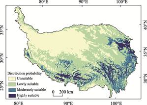
Figure 2
Distribution map of potential suitable areas for highland barley
cultivation in the Qinghai-Xizang Plateau during the current period
4.3.2 Validation of the Accuracy of
Preliminary Estimation Results
To
validate the simulation results for potential suitable cultivation areas of
highland barley, actual cultivation area data were used as validation samples.
These data were spatially overlaid with the areas predicted by the model as
unsuitable and suitable for cultivation, and the actual cultivation area and
its proportion within each category were calculated. A lower proportion of
actual cultivation area in areas predicted as unsuitable, together with a
higher proportion in areas predicted as suitable, indicates better model
prediction performance. The validation results are presented in Table 3.
Table 3 Validation of the accuracy of
preliminary estimates for highland barley potential suitable areas
|
Category
|
Area
|
Percentage
|
|
Area under highland
barley cultivation in suitable zones
|
27.37×10⁴ ha
|
99.88%
|
|
Area under highland
barley cultivation in unsuitable zones
|
3.15 ha
|
0.12%
|
4.4 Potential Suitable Areas for Highland Barley
Cultivation on the Qinghai-Xizang Plateau in the Near-Term Future
The
potential suitable areas for highland barley cultivation on the Qinghai-Xizang
Plateau in the near-term future are shown in Figure 3. The spatial distribution
pattern is generally consistent with that of the current period, although
slight differences can be observed among different climate scenarios. In terms
of temporal variation, the area of unsuitable regions gradually decreases,
whereas the areas of low-, moderate-, and high-suitability regions gradually
increase. The suitable areas are mainly distributed around the river valley
zones in the eastern part of the plateau and the Yarlung Zangbo River Basin in
the south. Meanwhile, the low-suitability zones, which were originally located
in climatic marginal areas, steadily expand toward high-altitude cold regions,
indicating an improvement in habitat conditions during the early stage of
climate warming and humidification. Across different scenarios, the area of
unsuitable regions under RCP8.5 is smaller than that under RCP4.5, while the
areas of moderate- and high-suitability regions are larger. This suggests that,
in the short term, the greenhouse effect under the high-concentration pathway
has a stronger positive driving effect on improving agricultural thermal
resources on the Qinghai-Xizang plateau.
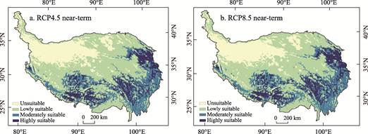
Figure 3 Distribution maps of potential suitable
areas for highland barley cultivation in the near-term future on the
Qinghai-Xizang Plateau
4.5 Potentially Suitable Areas for Highland Barley
Cultivation on the Qinghai-Xizang Plateau in the Medium-Term Future
The
potential suitable areas for highland barley cultivation on the Qinghai-Xizang
Plateau under the medium-term future scenario are shown in Figure 4. The
potential suitable areas for highland barley cultivation on the Qinghai-Xizang
Plateau under the medium-term future scenario are shown in Figure 4. By the
medium-term future, both the spatial boundaries and suitability levels of the
potential suitable areas for highland barley cultivation are projected to
change significantly. In terms of temporal variation, the cultivation
boundaries of suitable areas expand markedly from the current period to the
medium-term future. Areas currently classified as having no suitability for
cultivation are projected to shrink substantially by the medium-term future. In
particular, in the interior of the Qinghai-Xizang Plateau, the eastern part of
the Sanjiangyuan Region, and the southern Xizang valleys, habitat suitability
for highland barley shows a large-scale transition from no cultivation
suitability to low or moderate suitability. From the near-term future to the
medium-term future, the spatial structure of potential suitable areas for
highland barley cultivation becomes increasingly contiguous. The core areas
with high suitability shift from a scattered distribution to large-scale
clusters centered on river valleys, while the boundaries of
moderate-suitability areas show a clear tendency to extend northward and toward
higher elevations.
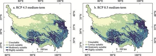
Figure 4 Distribution maps of potential suitable
areas for barley cultivation on the Qinghai-Xizang Plateau in the medium-term
future
From the
perspective of long-term trends, as the three time periods evolved, the area
unsuitable for highland barley cultivation has been shrinking, while the area
suitable for highland barley cultivation has correspondingly expanded. In the
medium-term future, when comparing the two scenarios, the area of medium- and
high-suitability zones for highland barley cultivation under the RCP4.5
scenario is smaller than that under the RCP8.5 scenario, while the area of
unsuitable zones is larger than that under the RCP8.5 scenario. At the same
time, the medium-term future under the RCP8.5 scenario is the period with the
lowest proportion of unsuitable areas and the highest proportion of highly
suitable areas, reflecting how extreme emission scenarios profoundly reshape
the upper limits of high-altitude crop cultivation. In terms of spatial
distribution, the suitability for highland barley cultivation in the
northwestern Qinghai-Xizang Plateau and the Qaidam Basin decreases or remains
largely unchanged, while in the southern, central, and eastern parts of the
Qinghai-Xizang plateau, suitability increases significantly, with the rate of
increase becoming more pronounced over time.
5 Discussion and Conclusion
This
dataset uses current data on highland barley cultivation areas on the
Qinghai-Xizang Plateau to generate random highland barley sample points. Based
on the MaxEnt model and environmental variables affecting highland barley
cultivation, it estimates potential suitable areas for highland barley
cultivation in the current period, the near-term future, and the medium-term
future. Simultaneously, the accuracy of the simulation results is verified by
comparing the current-period estimates with the current highland barley
cultivation area data on the Qinghai-Xizang Plateau to ensure greater accuracy
in predicting potential suitable areas for highland barley cultivation under
the two future scenarios, thereby obtaining spatial distribution data at the
grid scale for suitable highland barley cultivation areas. The dataset reflects
the overall temporal changes in the spatial patterns of potential suitable
areas for highland barley cultivation on the Qinghai-Xizang Plateau across
different future periods and scenarios. It demonstrates that while habitat
conditions improve during the early stages of climate warming and moistening,
extreme emission scenarios also affect the upper limits of cultivation for
high-altitude crops.
This dataset can
be used to analyze the spatial distribution of suitable areas for highland
barley cultivation under various future scenarios. It not only provides a basis
for optimizing highland barley cultivation patterns and conducting quantitative
assessments of disaster exposure, but also offers data support for
decision-making related to the development of distinctive agriculture on the
Qinghai-Xizang Plateau, food security, and climate change adaptation. This dataset supported the first author’s doctoral thesis
in Science.
Author Contributions
Wei, Y. and Liu, X.
processed the data and authored the data paper; Liu, F. G., Zhou, Q. and Chen,
Q. designed the algorithms based on the model; Ma, W. D. oversaw the overall
design of the dataset development; Wei, Y. implemented and validated the data.
Acknowledgements
I am deeply
grateful to my supervisor, Ma, W. D., for his invaluable guidance and support
during the writing of this thesis.
Conflicts of
Interest
The
authors declare no conflicts of interest.
References
[1]
Zhou, T. J., Chen, X. L.,
Zhang, W. X., et al. Interpretation and implications of the chapter
outline of the working group I contribution to the IPCC seventh assessment report
[J]. Climate Change Research, 2025, 21(4): 477–483.
[2]
Ding, J., Cao, Z. N., Hu, G.
Z., et al. Climate change impacts, adaptation and vulnerability and
implications in working group II of the IPCC seventh assessment report [J]. Climate
Change Research, 2025, 21(4): 484–493.
[3]
Tan, X. C., Cheng, Y. L., Yan,
H. S., et al. Interpretation and implications of the summary on climate
change mitigation in the IPCC seventh assessment report working group III [J]. Climate
Change Research, 2025, 21(4): 494–501.
[4]
Zhang, Q. P., Gu, X. Challenges
and responses: climate change and global agricultural production [J]. Ecological
Economy, 2025, 41(4): 5–8.
[5]
Pan, K. W., He, Y., Tang, Y.
W., et al. Progress of the scientific expedition and research on farmland
ecosystem and food security in Qinghai-Xizang Plateau [J]. Chinese Journal
of Applied and Environmental Biology, 2022, 28 (4): 813–821. DOI:
10.19675/j.cnki.1006-687x.2022.07032.
[6]
Hao, Y., Song, Y. L., Sun, S., et
al. Review on the impacts of climate change on highland barley production
in Qinghai-Xizang Plateau [J]. Chinese Journal of Agrometeorology, 2023,
44(5): 398–409.
[7]
Ye, Y.
C., Dou, Q. F., Gao, G. S., et al. Main
influencing factors of yield formation and agronomic characters of highland
barley in Qinghai Plateau [J]. Advances in Meteorological Science and
Technology, 2023, 13(4): 80–86.
[8]
Ma, W. D., Su, P., Jia, W., et
al. Advances in the research on the exposure of highland barley natural
disasters on the background of climate change [J]. Journal of
Catastrophology, 2020, 35 (4): 215–221.
[9]
Wei, Y., Liu, X., Ma, W. D., et
al. Dataset of potential suitable areas estimation for barley cultivation
on the Qinghai-Xizang Plateau under two different climate scenarios [J]. Digital Journal of Global Change Data Repository,
2026. https://doi.org/10.3974/geodb.2026.04.06.V1.
[10] GCdataPR
Editorial Office. GCdataPR data sharing policy [OL].
https://doi.org/10.3974/dp.policy.2014.05 (Updated 2017).
[11] Ma, W. D., Jia, W., Feng, X. Y., et al. Spatial distribution
dataset of barley cultivation area in the Qinghai-Xizang Plateau region in 2019
[J/OL]. Chinese Science Data, 2023, 8(1). DOI: 10.11922/11-603
5.csd.2022.0092.zh.
[12] Zhang, Y. L., Li, B. Y., Zheng, D. Geographic information system
data of Qinghai-Xizang plateau range and boundary [DB/OL]. Digital Journal
of Global Change Data Repository, 2014.
https://doi.org/10.3974/geodb.2014.01.12.V1.
[13] Zhang, Y. L., Li, B. Y., Zheng, D. Datasets of the boundary and area
of the Tibetan Plateau [J]. Acta Geographica Sinica, 2014, 69(Supplement):
65–68.
[14] Ma, W. D. Evaluation of impact of
climate change on highland barley cultivation in Qinghai-Xizang Plateau [D]. Xining: Qinghai Normal University, 2022. DOI:
10.27778/d.cnki.gqhzy.2022.000690.