JIANG Yujin1, 2 YANG Meng3 HE Ju4 LU Yanxu5 LIU Yuping3 YE Peng3*
1. Zhejiang Academy of Culture
and Tourism Development, Hangzhou 311231, China;
2. School of Applied Digital Technology, Tourism College of Zhejiang,
Hangzhou 311231, China;
3. College of Civil Engineering and Transportation,
Yangzhou University, Yangzhou 225127, China;
4. Institute for Rural Revitalization Strategy,
Yangzhou University, Yangzhou 225009, China;
5. Key
Laboratory of Virtual Geographic Environment, Nanjing Normal University,
Ministry of Education, Nanjing 210023, China
Abstract:
Scenic spots are the most distinctive type of natural protected areas in China,
not only carrying the functions of protecting natural and cultural heritage,
but also playing a significant role in optimizing urban and rural living
environments, ensuring regional ecological security, inheriting excellent
Chinese culture, enhancing public identification with the country, and meeting
the spiritual and cultural needs of the masses. Based on the 244 national-level
scenic spots lists released by the State Council nine times in 1982, 1988,
1994, 2002, 2004, 2005, 2009, 2012, and 2017, the author extracted the
geographical coordinates of each key cultural relic protection unit using the
Baidu Map service interface and verified the data based on Google Earth,
obtaining a spatial distribution dataset of China’s national-level scenic
spots. The dataset includes information such as the name, type, batch, and
zoning of each national-level scenic spot. The dataset is archived in .shp and
.xlsx formats, and consists of 7 data files with data size of 989 KB
(compressed into one single file with 78.5 KB).
Keywords: Scenic and Historic Areas; national level; national park; spatial distribution; China
DOI: https://doi.org/10.3974/geodp.2026.04.08
Dataset Availability Statement:
The dataset supporting this paper
was published and is accessible through the Digital Journal of Global Change Data Repository
at: https://doi.org/10.3974/geodb.2025.05.02.V1.
1 Introduction
In
order to more effectively maintain important ecosystems and promote the
long-term preservation and rational utilization of natural ecological heritage
and natural cultural heritage based on authenticity and integrity, China has
been continuously promoting the construction of the national park system in
recent years. In 2013, China explicitly proposed the establishment of a
national park system for the first time at the national level. Subsequently,
the Integrated reform plan for promoting ecological progress, issued in 2015,
and scientifically delineate national park boundaries on this basis. By 2022,
the National Forestry and Grassland Administration, issued the Spatial layout plan
for national parks, setting the goal of fundamentally establishing the national
park system by 2035[1].
The
International Union for Conservation of Nature (IUCN) generally defines
national parks as large-scale natural or near-natural areas; consequently,
national parks are incorporated into the overarching category of protected
areas[2]. Meanwhile, according to China’s Regulations on Scenic and
Historic Areas, regions that possess aesthetic, cultural, or scientific values,
feature concentrated distributions of natural and cultural landscapes, maintain
favorable environmental conditions, and have sufficient scale to accommodate
tourism, recreation, alongside scientific and cultural activities, can be
legally designated as Scenic and Historic Areas[3]. Consequently,
Scenic and Historic Areas and national parks are not disjointed in their
connotations; rather, they share strong commonalities in resource conservation
and public service. For this reason, within the current protected area system,
which takes national parks as the mainstay and nature reserves as the
foundation, the functional positioning of Scenic and Historic Areas under the
national park framework is drawing increasing attention.
Scenic and
Historic Areas represent a distinctly indigenous category of protected areas in
China, with their institutional origins tracing back to 1982, when the national
management system for these areas was formally established. As natural and
cultural heritage conservation zones legally designated by the state, they rely
primarily on natural landscape resources while carrying profound cultural
accumulation, exhibiting an intertwining of natural elements and cultural
connotations. They undertake multiple functions, including ecological
conservation, cultural continuation, aesthetic education, scientific research,
tourism and recreation, and driving regional development, thus possessing
immense ecological, scientific, cultural, and aesthetic values[4].
Embodying the cumulative outcomes of prolonged natural evolution and
historical-cultural accumulation, these areas serve as vital spaces for
observing natural and cultural history, while also exemplifying the harmonious
coexistence between humanity and nature. Over 40 years of continuous
development, they have played an exceptionally prominent role in conserving
natural and cultural heritage, optimizing urban and rural living environments,
safeguarding ecological security, preserving and transmitting fine Chinese
culture, fostering the public’s patriotic sentiment, and enriching the cultural
lives of the people[5].
National-level
Scenic and Historic Areas are typically regions characterized by the most
concentrated scenic resources and the most outstanding heritage values. In
practice, they have naturally become primary targets for intensive government
investment, sustained academic focus, and dense public visitation[6].
This dataset provides spatial distribution data for 244 national-level Scenic
and Historic Areas across 9 batches established over the four decades since the
inception of the system. The data content encompasses foundational information
such as announcement batches, typological classifications, and corresponding
administrative divisions, thereby offering a robust data foundation for
analyzing the spatio-temporal distribution patterns of national-level Scenic
and Historic Areas. From a spatio-temporal perspective, the dataset also seeks
to substantiate the status of China’s Scenic and Historic Areas as a crucial
type of protected area. Ultimately, it aims to provide valuable references for
the selection of national parks in the new era, the functional repositioning
and typological optimization of Scenic and Historic Areas, as well as the
implementation of customized, zoning-based management policies.
2 Metadata of Dataset
The
metadata of the Spatial distribution dataset of 244 Scenic and Historic Areas
in nine batches of China[7] is summarized in Table 1. It includes
the dataset full name, short name, authors, year of the dataset, temporal
resolution, spatial resolution, data format, data size, data files, data
publisher, and data sharing policy, etc.
Table 1 Metadata summary of the Spatial distribution dataset of
244 Scenic and Historic Areas in nine batches of China
|
Items
|
Description
|
|
Dataset full name
|
Spatial distribution dataset of 244 Scenic
and Historic Areas in nine batches of China
|
|
Dataset short name
|
NationalPark_China_1982-2017
|
|
Authors
|
Jiang, Y. J., Zhejiang Academy of Culture and Tourism Development; School
of Applied Digital Technology, Tourism College of Zhejiang,
jiangyujin@tourzj.edu.cn
Yang, M., College of Civil
Engineering and Transportation, Yangzhou University, emyangmeng@
163.com
He, J., Institute for Rural
Revitalization Strategy, Yangzhou University, torchheju@163.com
Lu, Y. X., Key Laboratory of
Virtual Geographic Environment, Nanjing Normal University, Ministry of
Education, 191301019@njnu.edu.cn
Liu, Y. P., College of Civil
Engineering and Transportation, Yangzhou University, 006958@yzu.edu.cn
Ye, P., College of Civil
Engineering and Transportation, Yangzhou University, 007839@yzu.edu.cn
|
|
Geographical region
|
China, covering 31 provincial-level administrative
regions (excluding data for Hong Kong, Macau, and Taiwan)
|
|
Year
|
1982–2017
|
|
Temporal resolution
|
Year
|
|
Spatial resolution
|
County
|
|
Data format
|
.shp, .xlsx
|
|
Data size
|
989 KB
|
|
Data files
|
The name, type, batch,
administrative division, and other information of each national scenic spot
|
|
Foundations
|
Zhejiang Province
(2025C25025); Yangzhou University (xjj2021-08); Yangzhou City (2024YZD-
005)
|
|
Data computing
environment
|
ArcGIS 10.2
|
|
Data publisher
|
Global Change
Research Data Publishing & Repository, http://www.geodoi.ac.cn
|
|
Address
|
No. 11A, Datun Road, Chaoyang District,
Beijing 100101, China
|
|
Data sharing policy
|
(1) Data
are openly available and can be free downloaded via the Internet; (2) End
users are encouraged to use Data
subject to citation; (3) Users, who are by definition also value-added
service providers, are welcome to redistribute Data subject to written permission from the GCdataPR Editorial
Office and the issuance of a Data
redistribution license; and (4) If Data
are used to compile new datasets, the “ten percent principle” should be
followed such that Data records
utilized should not surpass 10% of the new dataset contents, while sources
should be clearly noted in suitable places in the new dataset[8]
|
|
Communication and
searchable system
|
DOI, CSTR, Crossref, DCI,
CSCD, CNKI, SciEngine, WDS, GEOSS, PubScholar, CKRSC, OARL
|
3 Methods
A
comprehensive collection of the 9 batches of Scenic and Historic Areas of China
designated between 1982 and 2017 was conducted. These parks were classified in
accordance with the Classification criteria for Scenic and Historic Areas
(CJJ/T 121—2008)[9] and the 2017 Draft classification criteria for
Scenic and Historic Areas (provisional)[10]. The geocoding services
provided by web mapping platforms were utilized to extract administrative
information and spatial coordinates for each Scenic and Historic Area of China,
followed by the supplementation of relevant attribute data, and the ArcGIS
platform was subsequently employed to achieve the spatial representation and
visualization of these locations, which ultimately led to the construction of
the spatial distribution dataset for the Scenic and Historic Areas of China.
3.1 Data Sources
The
list of Scenic and Historic Areas of China was compiled from official notices
published on the Chinese Government Portal. Details of these notices, including
titles and release dates, are summarized in Table 2.
Table
2 Official notices designating Scenic and Historic Areas
of China
|
Batch
|
Official notice
title
|
Release date
|
Number
|
|
1
|
Notice of the State Council on approving and transmitting
the request for reviewing the first batch of Scenic and Historic Areas of
China
|
Nov. 8, 1982
|
44
|
|
2
|
Notice of the State Council on approving and transmitting
the report for reviewing the second batch of Scenic and Historic Areas of
China
|
Aug. 1, 1988
|
40
|
|
3
|
Notice of the State Council on publishing the third
batch of Scenic and Historic Areas of China
|
Jan. 10, 1994
|
35
|
|
4
|
Notice of the State Council on publishing the fourth
batch of Scenic and Historic Areas of China
|
May 17, 2002
|
32
|
|
5
|
Notice of the State Council on publishing the fifth
batch of Scenic and Historic Areas of China
|
Jan. 13, 2004
|
26
|
|
6
|
Notice of the State Council on publishing the sixth
batch of Scenic and Historic Areas of China
|
Dec. 31, 2005
|
10
|
|
7
|
Notice of the State Council on publishing the seventh
batch of Scenic and Historic Areas of China
|
Dec. 28, 2009
|
21
|
|
8
|
Notice of the State Council on publishing the eighth
batch of Scenic and Historic Areas of China
|
Oct. 31, 2012
|
17
|
|
9
|
Notice of the State Council on publishing the ninth
batch of Scenic and Historic Areas of China
|
Mar. 21, 2017
|
19
|
The official
names of Scenic and Historic Areas of China correspond to those specified in
the respective notices. For instance, the Wuyang River (“潕阳河”) Scenic and Historic Area of
China (also locally referred to as Wuyanghe (“㵲阳河”) or Wuyanghe (“舞阳河”)) exemplifies regional naming variations. Additionally, the
official notices for national-level Scenic and Historic Areas only include the
names of the designated areas and their provincial administrative divisions,
with the provincial classification based on the historical administrative
boundaries at the time of their announcement. Furthermore, due to limitations
in data availability, data for the Hong Kong, Macao, and Taiwan regions are not
included in the current statistical scope.
3.2 Data Processing
(1)
Geocoding
Given that the
officially released directories of national-level Scenic and Historic Areas
typically lack explicit latitude and longitude data, the names of the areas
alongside their corresponding provincial administrative divisions were utilized
as query criteria. Specifically, the Baidu Maps Place API was invoked to
conduct geocoding and extract the relevant spatial coordinates. Upon obtaining
the initial results, a coordinate conversion tool was applied to convert the
BD09 coordinate system used by Baidu Maps into the China Geodetic Coordinate
System 2000 (CGCS2000), thereby ensuring consistency for standardized data
consolidation and subsequent spatial analysis.
(2)
Administrative division supplementation
While the
initially published directories of national-level Scenic and Historic Areas
included provincial administrative division information, the designation of
these batches spans a prolonged timeframe. Consequently, the original
administrative affiliations and corresponding spatial extents of certain areas
have shifted alongside subsequent administrative division adjustments. Driven
by the necessity for data currency and the requirements of downstream spatial
analysis, the Baidu Maps Global Reverse Geocoding API was additionally
employed. Based on their respective geographic coordinates, the current and
up-to-date administrative jurisdictions of all national-level Scenic and
Historic Areas were systematically identified and updated.
(3) Division the
category for Scenic and Historic Areas
The Classification criteria for Scenic and Historic Areas (CJJ/T 121—2008), an industry standard issued by the Ministry of Housing and Urban-Rural Development of China,
categorizes Scenic and Historic Areas of China into 14 classes based on core
attributes: historical sacred sites, mountain landscapes, karst caves &
rock formations, rivers & waterways, lakes & wetlands, coastal &
island sceneries, unique geological landforms, urban landscapes, biodiversity
& ecological reserves, mural & grotto heritage, memorial &
historical sites, imperial tombs & mausoleums, ethnic & folk cultural
landscapes, Other categories.
In October 2017,
the Draft classification criteria for Scenic and Historic Areas (provisional)
was submitted to the Department of Standards and Quotas under the Ministry of
Housing and Urban-Rural Development of China. However, no updated standards
have been officially released to date. The draft criteria propose classifying Scenic
and Historic Areas of China into 4 categories—sanctuary, ecological, heritage,
and cultural heritage—based on their intrinsic characteristics and resource
values.
In this dataset,
the 244 Scenic and Historic Areas of China were classified according to the
categorization criteria outlined in both the current Classification criteria
for Scenic and Historic Areas (CJJ/T 121—2008) and the Draft
classification criteria for Scenic and Historic Areas (provisional). For
parks comprising dual-type landscapes, classification principles were applied
as follows: under the CJJ/T 121—2008 standard, parks with components sharing
the same category (e.g., Fuchun River-Xin’an River and Wangwu Mountain-Yuntai
Mountain Scenic and Historic Areas of China, both classified as Riverine or
Mountain Landscapes) were assigned their common category. Dual-type Scenic and
Historic Areas that fall into divergent categories are classified under “Others”
(e.g., the Yueyang Tower-Dongting Lake, Lintong Lishan Mountain-Qin Terracotta
Warriors, and Mingsha Mountain-Crescent Spring Scenic and Historic Areas). For
the draft criteria, according to the instructions in the standard
specifications, when two or more types appear in a scenic and historic area,
the higher ranked type is selected in the order of “sanctuary→ecological→heritage→cultural
heritage”. The classification results of these two criteria are jointly saved
in the dataset.
4 Data Results
4.1 Dataset Composition
The
Spatial distribution dataset of 244 Scenic and Historic Areas in nine batches
of China comprises 2 components: (1) vector geospatial data of Scenic and Historic
Areas (.shp format), and (2) attribute data, including park names, designation
years, batches, classifications, and administrative divisions (.xlsx format)
(Table 3).
Table 3 Attribute fields
of dataset
|
Field
name
|
Description
|
|
Index
|
1, 2, 3,…, 244
|
|
Name
|
Badaling–Ming Tombs, Shihua Cave, Panshan, …
|
|
Classification
|
Lake landscapes, Riverine landscapes,
Mountain landscapes, …
|
|
Provincial division
|
Jiangsu Province, Beijing Municipality,
Xinjiang Uygur Autonomous Region, …
|
|
Municipal division
|
Nanjing City, Changsha City, Kaifeng City, …
|
|
County division
|
Laishui County, Jingxing County, Zanhuang
County, …
|
|
Batch
|
Batch 1, Batch 2, Batch 3, …
|
|
Date of promulgation
|
1982.11.8, 1988.8.1, 1994.1.10, …
|
4.2 Data Results Analysis
|
|
|
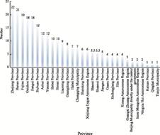
Figure 1 Statistics on the number of provincial distribution
of Scenic and Historic Areas
|
|
|
|
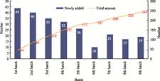
Figure 2
Statistics of the number of Scenic and Historic Areas in different
batches
|
In
terms of provincial distribution, Zhejiang leads the country with 22 national-
level Scenic and Historic Areas, followed by Hunan (21), Fujian (19), and both
Jiangxi and Guizhou (18 each). Spatially, these areas are primarily
concentrated in Southeast China. Conversely, Tianjin, Ningxia, and Qinghai
record the lowest counts with merely one each (Figure 1). Notably, Shanghai
currently possesses no such designated areas. A unique case is the Hukou
Waterfall Scenic and Historic Area of China, which spans Linfen City (Shanxi
Province) and Yan’an City (Shaanxi Province). Due to its transboundary nature,
this park is counted as 0.5 sites in each province’s total.
From a temporal
perspective, since the designation of the first batch of Scenic and Historic
Areas of China in 1982, the total number of these parks has exhibited a steady
increase, rising from 44 in 1982 to 244 in 2017, with an average batch- wise
growth rate of 25.1% (Figure 2). Among provincial-level administrative divisions,
Zhejiang, Hunan, and Fujian have consistently ranked among the top provinces in
terms of park quantity. Zhejiang and Sichuan jointly led the first batch with 4
parks each. Notably, Zhejiang and Hunan are the only provinces to have secured
designations across all 9 batches. The Inner Mongolia Autonomous Region, which
received its first Scenic and Historic Area of China in 2002, represents the
most recent addition among all provinces with designated parks.
From a
typological perspective, China is rich in landscape resources, with mountains
and hills occupying two-thirds of its landmass. The rugged terrain, alongside
various natural elements (e.g., rocks, soils, flora, and fauna), forms a high
level of geodiversity and biodiversity, granting these areas significant
ecological and aesthetic values. Simultaneously, China possesses vast river and
lake networks. Based on the Bulletin of the first national census of water
(2010–2012) issued by the Ministry of Water Resources and the National Bureau
of Statistics, there are 2,221 rivers with a drainage area ≥1,000 km2,
totaling 386,500 km in length. Additionally, 2,865 lakes maintain a perennial
water surface area ≥1 km2, totaling 78,000 km2.
Driven by this
natural background, China’s Scenic and Historic Areas spatially tend to cluster
around mountains and waters. River- and lake-type areas together comprise 28.8%
of the total. GIS analysis reveals that 29.5% (72 areas) are situated within a
20-km buffer zone of major rivers, and 48% (117 areas) are within a 40-km
buffer. From a provincial perspective, the proportion of river-type areas is
notably higher in Zhejiang, Fujian, Guizhou, and Yunnan. Meanwhile, coastal
provinces such as Zhejiang, Fujian, and Liaoning have a greater concentration
of lake-type and coastal/island-type areas. Mountain-type Scenic and Historic
Areas are widely distributed across the majority of provincial-level regions in
China, with a particularly high concentration of such designated areas found in
Zhejiang, Hunan, Fujian, Jiangxi, Henan, and Sichuan (Figure 3).
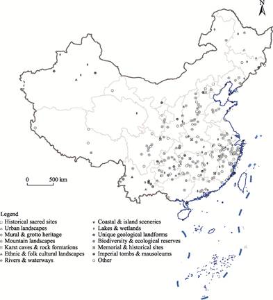
Figure 3
Distribution map of different types of Scenic and Historic Areas in China
5 Discussion and Conclusion
A
comprehensive understanding of the spatial distribution of Scenic and Historic
Areas of China is critical for informing resource conservation, tourism
development, and sustainable management strategies, while also serving as a
scientific reference for national and provincial-level planning. This dataset
compiles comprehensive data on 244 national-level Scenic and Historic Areas,
which were promulgated by the State Council in 9 batches between 1982 and 2017.
The dataset encompasses critical attribute information for each area, such as
identification code, name, typological classification, and designation batch,
while simultaneously integrating spatial data, including geographic
coordinates and administrative jurisdictions. On this basis, the dataset still
has room for further exploration and expansion. It can be combined with
relevant data such as the natural protected area system, transportation
routes, ecological environment background, and socio-economic data to conduct
comparative analysis on the spatial pattern, type differentiation, and regional
differences of national scenic spots, thereby enhancing the application value
in the protection, management, planning, evaluation, and related research of
scenic spots.
Author Contributions
Jiang, Y. J. and Ye, P. conducted the overall
design of the dataset development; Yang, M. and He, J. collected and processed
the data of Scenic and Historic Areas of China; Lu, Y. X. and Liu, Y. P. made
data analysis and verification; Ye, P. wrote the data paper; Jiang, Y. J.
reviewed the data paper.
Conflicts of Interest
The authors declare no conflicts of interest.
References
[1]
National Forestry and Grassland
Administration, Ministry of Finance, Ministry of Natural Resources, Ministry of
Ecological Environment. Spatial layout plan for national parks [EB/OL].
(2022-12-30) [2025-04- 21].
https://www.gov.cn/xinwen/2022-12/30/content_5734221.htm.
[2]
Yan, G. T., Song, L. The value
and development path of Scenic and Historic Area under the national park system
[J]. Chinese Landscape Architecture,
2021, 37(3): 112–117.
[3]
National Forestry and Grassland
Administration. Regulations on Scenic and Historic Areas [EB/OL]. (2016-02-06) [2025-04-
21]. https://www.forestry.gov.cn/c/www/gkxzfg/659976.jhtml.
[4]
Zhang, T. S., Sun, Y. Z.
Spatial characteristics and functions of national scenic spots in China [J]. Urban Development Studies, 2019, 26(8):
6–12.
[5]
Fu, L. Q., Zong, C., Kong, S., et
al. The spatial distribution of National Nature Reserves and National
Scenic Areas and ecotourism potential analysis [J]. Chinese Journal of Wildlife, 2015, 36(2): 218–223.
[6]
Wu, J. Y. Study on spatial
distribution characteristics of Chinese National Parks [J]. Geographical Research, 2014, 33(9):
1747–1757.
[7]
Jiang, Y. J., Yang, M., He, J.,
et al. Spatial distribution dataset of 244 national parks in nine batches
of China [J/DB/OL]. Digital Journal of Global Change Data Repository,
2025. https://doi.org/10.3974/geodb. 2025.05.02.V1.
[8]
GCdataPR Editorial Office.
GCdataPR data sharing policy [OL]. https://doi.org/10.3974/dp.policy.2014.05
(Updated 2017).
[9]
Ministry of Housing and
Urban-Rural Development of P. R. China. Classification criteria for Scenic and
Historic Areas (CJJ/T 121—2008) [S]. Beijing: China Architecture & Building
Press, 2008.
[10]
National Technical Committee on
Digital Standardization for Intelligent Buildings and Residential Areas.
Ministry of Housing and Urban-Rural Development releases “Draft classification
criteria for Scenic and Historic Areas (provisional)” [OL].
http://www.ibrc426.com/newsitem/277843880.