Global Change Data Encyclopedia
Orkney Islands, United Kingdom
Zhang, Y. H. Liu, C.* Shi, R. X.
Institute of Geographic Sciences and Natural Resources Research, Chinese Academy of Sciences, Beijing 100101, China
Keywords: Orkney Islands; Atlantic Ocean; Scotland; mainland; data encyclopedia
|
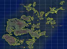
Figure 1 Map of Orkney Islands dataset (.kmz format)
|
The Orkney Islands is located in Scotland, northeastern the United Kingdom, lying about 32 km north of the Scottish mainland[1], between Northern Atlantic Ocean and North Sea, the Great British and Shetland Islands[2]. Its geo-location is 58°43′46″N–59°23′59″N, 3°26′12″W– 2°22′11″W[3] (Figures 1–2).
|
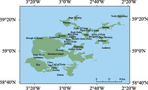
Figure 2 Map of Orkney Islands dataset (.shp format)
|
There are 104 islands and islets with area bigger than 70 m2 in Orkney Islands including small islands, isles and independent rocks[3]. The largest one of the islands is Mainland. The small islands of Lamb Holm (58°53′16″N, 2°53′36″W), Glims Holm (58°52′32″N, 2°55′4″W), Burray (58°51′12″N, 2°54′ 27″W) and South Ronaldsay (58°47′45″ N, 2°57′13″ W), to the south of the Mainland, are now joined successively to it by constructed causeways. Its area is 581.85 km2 and its coastline length is 368.51 km. The second largest island of the Orkney Islands, Hoy, lies southwest of the Mainland, along with smaller islands such as Graemsay, Cava, Fara, Calf of Flotta, Switha and Flotta. To the north of Mainland lie Shapinsay, Rousay, Egilsay, Stronsay, Eday, Westray, Papa Westray, Sanday, North Ronaldsay, Gairsay, Wyre, Westray, and several smaller islands. The total area of the British Isles is 1,037.24 km2 and the total coastline length of it is 1,076.4 km (Table 1).
Table 1 Geo-location, area and coastline of main islands of the Orkney Islands
|
Name of island
|
Geo-location
|
Center of island
|
Area
(km2)
|
Coastline (km)
|
|
Mainland Island
|
58°43′46″N–59°9′16″N, 3°22′5″W–2°42′10″W
|
58°59′28″N, 3°5′38″W
|
581.85
|
368.51
|
|
Hoy
|
58°46′17″N–58°55′57″N, 3°26′12″W–3°7′47″W
|
58°51′5″N, 3°17′39″W
|
146.38
|
95.42
|
|
Sanday
|
59°11′2″N–59°18′48″N, 2°42′6″W–2°23′22″W
|
59°15′28″N, 2°33′56″W
|
52.40
|
106.90
|
|
Westray
|
59°13′39″N–59°21′37″N, 3°4′24″W–2°50′11″W
|
59°17′46″N, 2°57′38″W
|
49.15
|
79.36
|
|
Rousay
|
59°7′35″N–59°12′1″N, 3°7′14″W–2°57′8″W
|
59°9′38″N, 3°2′13″W
|
48.07
|
36.34
|
|
Stronsay
|
59°4′11″N–59°9′45″N, 2°41′27″W–2°31′34″W
|
59°6′30″N, 2°36′32″W
|
37.29
|
65.84
|
|
Eday
|
59°8′16″N–59°15′4″N, 2°49′42″W–2°44′0″W
|
59°11′20″N, 2°46′30″W
|
28.91
|
40.79
|
|
Shapinsay
|
59°1′1″N–59°5′16″N, 2°56′7″W–2°47′53″W
|
59°2′56″N, 2°51′34″W
|
28.75
|
40.37
|
|
Flotta
|
58°48′46″N–58°50′59″N, 3°8′55″W–3°3′50″W
|
58°49′46″N, 3°6′36″W
|
10.10
|
22.85
|
|
Papa Westray
|
59°19′23″N–59°23′11″N, 2°54′41″W–2°52′4″W
|
59°21′13″N, 2°53′27″W
|
8.95
|
19.24
|
|
North Ronaldsay
|
59°20′50″N–59°23′34″N, 2°27′4″W–2°22′11″W
|
59°22′16″N, 2°25′4″W
|
8.10
|
20.45
|
|
Egilsay
|
59°7′26″N–59°10′13″N, 2°56′43″W–2°54′25″W
|
59°9′5″N, 2°55′35″W
|
6.35
|
14.07
|
|
Graemsay
|
58°55′11″N–58°56′28″N, 3°18′54″W–3°15′55″W
|
58°55′47″N, 3°17′26″W
|
4.16
|
9.40
|
|
Wyre
|
59°6′37″N–59°7′40″N, 3°0′48″W–2°57′4″W
|
59°7′6″N, 2°58′25″W
|
3.22
|
9.67
|
|
Fara
|
58°49′58″N–58°51′26″N, 3°10′55″W–3°8′57″W
|
58°50′37″N, 3°9′58″W
|
3.06
|
7.94
|
|
Gairsay
|
59°4′18″N–59°5′31″N, 2°59′37″W–2°56′45″W
|
59°4′56″N, 2°58′18″W
|
3.01
|
10.42
|
|
Calf of Eday
|
59°13′42″N–59°14′53″N, 2°44′52″W–2°43′1″W
|
59°14′13″N, 2°44′4″W
|
2.21
|
7.05
|
|
Faray
|
59°12′6″N–59°13′39″N, 2°49′53″W–2°48′52″W
|
59°12′52″N, 2°49′26″W
|
1.58
|
7.29
|
|
Swona
|
58°44′4″N–58°45′9″N, 3°4′26″W–3°2′59″W
|
58°44′33″N, 3°3′32″W
|
1.14
|
6.09
|
|
Auskerry
|
59°1′29″N–59°2′21″N, 2°34′41″W–2°33′25″W
|
59°1′54″N, 2°34′11″W
|
1.07
|
5.19
|
|
Cava
|
58°52′18″N–58°53′16″N, 3°10′46″W–3°9′23″W
|
58°52′42″N, 3°10′6″W
|
0.99
|
4.95
|
|
Papa Stronsay
|
59°8′47″N–59°9′27″N, 2°36′12″W–2°34′31″W
|
59°9′6″N, 2°35′12″W
|
0.94
|
6.10
|
|
Eynhallow
|
59°8′21″N–59°8′55″N, 3°7′46″W–3°6′35″W
|
59°8′39″N, 3°7′13″W
|
0.82
|
3.81
|
|
Switha
|
58°47′42″N–58°48′15″N, 3°6′48″W–3°5′34″W
|
58°47′59″N, 3°6′11″W
|
0.55
|
3.54
|
|
Helliar Holm
|
59°1′6″N–59°1′42″N, 2°54′28″W–2°53′46″W
|
59°1′24″N, 2°54′4″W
|
0.47
|
3.19
|
|
Holm of Faray
|
59°13′45″N–59°14′32″N, 2°50′10″W–2°49′33″W
|
59°14′5″N, 2°49′50″W
|
0.44
|
4.03
|
|
Muckle Green Holm
|
59°7′25″N–59°7′60″N, 2°50′2″W–2°49′28″W
|
59°7′43″N, 2°49′44″W
|
0.44
|
2.74
|
|
Holm of Huip
|
59°9′40″N–59°10′16″N, 2°39′23″W–2°38′45″W
|
59°9′57″N, 2°39′2″W
|
0.36
|
2.65
|
|
Holm of Papa
|
59°20′43″N–59°21′19″N, 2°52′31″W–2°51′47″W
|
59°21′4″N, 2°52′7″W
|
0.33
|
3.03
|
|
Damsay
|
59°0′17″N–59°0′41″N, 3°4′9″W–3°3′28″W
|
59°0′29″N, 3°3′49″W
|
0.31
|
2.38
|
|
Holm of Scockness
|
59°9′45″N–59°10′10″N, 2°57′21″W–2°56′45″W
|
59°9′58″N, 2°57′4″W
|
0.28
|
2.16
|
|
Brough of
Birsay
|
59°8′2″N–59°8′18″N, 3°20′28″W–3°19′41″W
|
59°8′11″N, 3°20′6″W
|
0.26
|
2.05
|
|
Sweyn Holm
|
59°5′12″N–59°5′33″N, 2°57′29″W–2°56′48″W
|
59°5′22″N, 2°57′6″W
|
0.26
|
2.17
|
|
Calf of Flotta
|
58°51′6″N–58°51′19″N, 3°4′54″W–3°3′55″W
|
58°51′12″N, 3°4′25″W
|
0.23
|
2.18
|
|
Inner Holm
|
58°57′17″N–58°57′37″N, 3°17′30″W–3°17′10″W
|
58°57′26″N, 3°17′20″W
|
0.10
|
2.05
|
|
Midgarth
|
59°9′21″N–59°9′35″N, 2°41′27″W–2°41′6″W
|
59°9′27″N, 2°41′18″W
|
0.08
|
1.28
|
The dataset was developed based on the Google Earth and related maps and references[1–3]. The dataset is consisted of 15 data files and archived in the .kmz and .shp[4] data formats with the data size of 6.29 MB (Compressed to 2.72 MB in two files).
References
[1] World Map Atlas: United Kingdom Atlas [M]. Beijing: Sino Maps Press, 2007.
[2] Orkney Islands [OL]. Encyclopedia Britannica, Encyclopedia Britannica Inc., 20 Feb., 2019. https://www. britannica. com/place/Orkney-Islands.
[3] Liu, C., Shi, R. X. Orkney Islands [DB/OL]. Global Change Research Data Publishing & Repository, 2017. DOI: 10.3974/geodb.2017.01.11.V1.
Data Computing Environment
[4] ESRI. ArcGIS campus license of Institute of Geographic Sciences and Natural Resources Research,
Chinese Academy of Sciences.
URL for Data Downloading
http://www.geodoi.ac.cn/WebEn/doi.aspx?Id=649.
Or search through: http://www.geodoi.ac.cn.