Terrigeneous Components Dataset of Sediment Core ANT28-D1-7 from Bransfield Strait-Antarctic Peninsula
Nie, S. Y. Xiao, W. S. Wang, R. J.*
State Key Laboratory of Marine Geology, School of Ocean and Earth Science, Tongji University, Shanghai 200092, China
Abstract: The climate changes in Antarctic Peninsula region is particularly sensitive to global warming. Terrigeneous components including clay minerals and coarse fractions in the sediment provide direct information of the surrounding environment changes related to climate oscillations and ice-sheet instability. Multi-proxy investigations and regional core correlation have been performed on core ANT28-D1-7 collected from the Bransfield Strait during the 28th Chinese National Antarctic Expedition. The AMS 14C dating establishes the core stratigraphy of the past 5.83 ka, with mean responsibility of 53 cm per millennium. The dataset includes physical and chemical parameters and paleoenvironment proxies of core ANT28-D1-7, including: AMS14C dating results, clay mineral composition, coarse fractions, tephra concentration and so on with dataset format of excel and size of 156 KB.
Keywords: Antarctic Peninsula; clay mineral; tephra layer; Ice-Rafted Debris
1 Introduction
Historical observations indicate rapid warming over the past decades on the Antarctic Peninsula[1–4], an area sensitive to global climate change[3]. Paleoenviment records from this region are essential for understanding its response to global climate in the geological past. Of special interest is the Holocene, during which the climate is assumed stable and comparable to today. Terrigeneous components in the marine sediment provide important evidence of transportation mechanisms, and the environment changes in the surrounding source regions. However, few studies on terrigeneous components have been carried out on South Ocean sediments, including the Antarctic Peninsular region[5–7]. In this dataset, we show the composition of terrigeneous origin in sediment core ANT28-D1-7 from Bransfield Strait, Antarctic Peninsula region, and discuss the related transportation and environment changes of the region[7].
2 Metadata of Dataset
The metadata of terrigeneous components dataset of sediment core ANT28-D1-7[8] from Bransfield Strait, Antarctic Peninsula is summarized in Table 1. It includes the dataset full name, short name, authors, year of the dataset, temporal resolution, spatial resolution, data format, data size, data files, data publisher, and data sharing policy, etc.
Table 1 Summary of the ANT28-D1-7 metadata
|
Items
|
Description
|
|
Dataset full name
|
Terrigeneous components dataset from the ANT28-D1-7 sediment sample in Bransfield of Antarctic
|
|
Dataset short name
|
ANT28-D1-7
|
|
Authors
|
Nie, S. Y. L-6868-2016, State Key Laboratory of Marine Geology, School of Ocean and Earth Science, Tongji University, synie@tongji.edu.cn
Xiao, W. S. A-4650-2017, State Key Laboratory of Marine Geology, School of Ocean and Earth Science, Tongji University, wxiao@tongji.edu.cn
Wang. R. J. A-4207-2017, State Key Laboratory of Marine Geology, School of Ocean and Earth Science, Tongji University, rjwang@tongji.edu.cn
|
|
Geographical region
|
62°16.163′S, 56°35.457′W, 1,100 m water depth, Bransfield
|
|
Year
|
2012-2014
|
|
Data format
|
.xls
|
|
|
|
Data size
|
149 KB
|
|
|
|
Data files
|
The dataset consists of four files. They are AMS14C dating result, tephra concentration, coarse fraction and clay mineral composition
1. ANT28-D1-7-1.xls, AMS14C dating result of core ANT28 D1-7, 33.5 KB
2. ANT28-D1-7-2.xls, tephra concentration of core ANT28 D1-7, 38.5 KB
3. ANT28-D1-7-3.xls, coarse fraction of core ANT28 D1-7, 39 KB
4. ANT28-D1-7-4.xls, Clay mineral composition of core ANT28 D1-7, 38 KB
|
|
Foundation(s)
|
State Oceanic Administration of P. R. China (CHINARE2012-014-01-02)
|
|
Data publisher
|
Global Change Research Data Publishing & Repository, http://www.geodoi.ac.cn
|
|
Address
|
No. 11A, Datun Road, Chaoyang District, Beijing 100101, China
|
|
Data sharing policy
|
Data from the Global Change Research Data Publishing & Repository includes metadata, datasets (data products), and publications (in this case, in the Journal of Global Change Data & Discovery). Data sharing policy includes: (1) Data are openly available and can be free downloaded via the Internet; (2) End users are encouraged to use Data subject to citation; (3) Users, who are by definition also value-added service providers, are welcome to redistribute Data subject to written permission from the GCdataPR Editorial Office and the issuance of a Data redistribution license; and (4) If Data are used to compile new datasets, the ‘ten per cent principal’ should be followed such that Data records utilized should not surpass 10% of the new dataset contents, while sources should be clearly noted in suitable places in the new dataset[9]
|
3 Methods
3.1 Study Area
The gravity core ANT28-D1-7 (62°16.163′S??56°35.457′W, 1,100 m water depth) was collected from the Bransfield Strait, Antarctic Peninsula, during the 28th Chinese National Antarctic Expedition (Figure 1). The total core length is 307 cm, and it is sampled at 2-cm interval with a total of 154 samples. The analysis of core ANT28-D1-7 includes: AMS 14C dating, clay mineral composition, coarse fractions and tephra concentration.
3.2 Data Collection or Processing
AMS 14C was measured on 8 samples on organic carbon and 1 sample on benthic foraminifera Bulimina aculeata (150-250 μm). The AMS 14C dating was performed in BETA Analytic Inc., Miami. The rest analysis was carried out in the State Key Laboratory of Marine Geology, Tongji University, China.
For tephra abundance analysis, about 5 g dry sediment was treated with hydrogen peroxide and concentrated dydrochloric acid to remove carbonate and organic carbon. After completion of the reaction, the sediment was wet rinsed through an Φ 37 μm mesh. The residue was transferred to a 100 mL bottle and diluted to exactly 100 mL. One grease-free cover glass was placed in a petri dish that was filled with purified water containing a small concentration of gelatin. After the sample residue stored in the bottle had been resuspended carefully, a defined aliquot was taken from the center of the homogenized suspension using a pipette. The aliquot was randomly suspended in the petri dish. After a settling time of 1-2 h, the water was removed from the petri dish using a strip of absorptive paper. Use the mounting resin Canadian gum to keep the dry cover glasses sting to slide for permanent mounting. Light microscope investigation was made at 200× magnification.
|
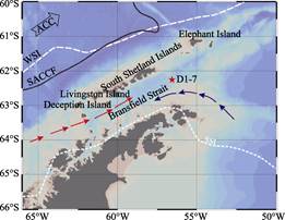
Figure 1 Location map of core D1-7 in the
Bransfield Strait
The Oceanographic settings and seasonal sea ice edges are indicated. Dark blue arrow is cold water from the Weddell Gyre, red arrow is surface water from Bellingshausen Sea. ACC is Antarctic Circumpolar Current, SACCF is Southern ACC Front[10], WSI and SSI are Sea Ice boundary in winter and summer, respectively[11]
|
For relative abundance of coarse fraction, about 15 g dry sediment was wet-rinsed through an Φ 63 μm mesh, then the >63 μm residue was dried sieved through Φ 150 μm and Φ 250 μm meshes successively. Foraminifers in the 150-250 μm and >250 μm fractions were separated and counted under the microscope. Finally, the residue coarse fractions which are considered as Ice Rafted Debris (>150 μm and >250 μm) were weighed and their contents (% of dry sediment) were calculated.
Clay minerals were identified by X-ray diffraction (XRD) on oriented mounts of noncalcareous clay-sized particles (<2 μm)[12–13]. XRD spectra were obtained using PANalytical X’Pert PRO diffractometer with CuKα. radiation and Ni filter, under a voltage of 45 kV and an intensity of 40 mA. Three XRD runs were performed following air drying, ethylene-glycol solvation for 24 h, and heating at 490 °C for 2 h. Identification of clay minerals was made mainly according to the position of the (001) series of basal reflections on the three XRD diagrams[13–14]. Semiquantitative estimates of peak areas of the basal reflections for the main clay mineral groups of smectites (smectite + mixed layer) (1.7 nm), illite (1 nm) and kaolinite/chlorite (0.7 nm) were carried out on the glycolated curve using the MacDiff software. Relative proportions of kaolinite and chlorite were determined based on the ratios of 0.357 nm/0.354 nm peak areas. Illite chemistry index was obtained by the ratio of the 0.5 nm/1 nm peak areas. Illite crystallinity was obtained from a half width of the 1 nm.
4 Results and Validation
4.1 Data Products
The dataset of ANT28-D1-7 file naming as ANT28_D1_7_4.xls with the data size of 149 KB, includes:
(1) AMS14C dating result, file name is ANT28-D1-7-1.xls, data size is 33.5 KB; The 14C ages were calibrated to calendar years using Calib 7.0.2 with Marine 13 dataset[8]. The data is consisted of the following items in depth from 0-100 cm: depth (cm), material, 14C age (a)±1σ, Reservoir corrected 14C age/a BP, and Calibrated age/a BP.
(2) Tephra concentration of core ANT28 D1-7, file name is ANT28_D1_7_2.xls, data size is 38.5 KB. The data is consisted of the following items in each of 10 samples: sample ID, depth (cm), mid-depth (cm), and tephra (No./g).
(3) Coarse fraction of core ANT28 D1-7, file name is ANT28-D1-7-3.xls , file size is 39 KB. The data is consisted of the following items in each of 2 cms from 0-20 cm in depth: depth (cm), mid-depth (cm), IRD>63 μm (%) and IRD>250 μm (%).
(4) Clay mineral composition of core ANT28 D1-7, file name is ANT28-D1-7-4.xls, file size is 37 KB. The data is consisted of the following items in each of 2 cms from 0-38 cm in depth: depth (cm), smectite (%), illite (%), kaolinite (%), chlorite (%), illite crystallinity (°Δ2θ) and illite chemistry index.
4.2 Validation
The AMS 14C Calibration in this dataset refers to Stuiver, et al., 1993[15] and Reimer, et al., 2013[16], the carbon reservoir effect used for calibration is 1,300 yrs[17–18]. Tephra concentration data were determined at 200× magnification under light microscope with an investigative area of 25 mm×1 mm. The result meets statistical requirements.Coarse fractions was separated from about 15 g dry sediment, ensuring the reliability of the data.Clay minerals were identified by X-ray diffraction (XRD) on oriented mounts of noncalcareous clay-sized particles (<2 μm) with an error of 2%.
5 Discussion and Conclusion
Through one sample of Bulimina aculeata shells (150-250 μm) and 8 samples of TOC AMS 14C tests, the stratigraphic framework of core ANT28-D1-7 was established, extending back to 5.83 ka. The estimated organic carbon based 14C age bias by the fossil carbon contamination is about 2.1 ka by interpolation. 7 layers containing abundant tephra were identified (0.33, 2.12, 2.82-2.94, 3.34, 3.96, 4.76 and 5.57 ka), which can be regionally correlated.
Clay mineral composition mainly consists of smectite (>60%), chlorite and illite. Kaolinite is generally less than 6%. Each part has a rather stable percentage except for the tephra layers, indicating the wreathing condition and the source is stable. Smectite remarkably increases in the major tephra layer. The clay mineral composition reflects the volcanic origin as the major source in this region, and it is affected by weathering intensity.
Coarse fractions represent tephra and IRD events during 5.8-3.6 ka and 3.6-0.28 ka, respectively. Frequent IRD events are recognized in the late Holocene interval and consistent with the adjacent records, suggesting increased glacial ice discharge during the late Holocene in the Antarctic Peninsula region, driven by the ENSO and seasonal insolation changes.
Author Contributions
Nie, S. Y., Xiao, W. S. and Wang, R. J. designed the study, wrote the paper, contributed to the data processing and analysis and gave the validation. Each of them spent much time doing this work. Their contribution is same.
Acknowledgements
The cruise members of CHINARE-2008 are appreciated for collecting the sample. We sincerely thank the aids from Zhang, T. L., Wang, L. and Mei, J.
References
[1] Mulvaney, R., Abram, N. J., Hindmarsh, R. C., et al. Recent Antarctic Peninsula warming relative to Holocene climate and ice-shelf history [J]. Nature, 2012, 489(7414): 141-144.
[2] Mayewski, P. A., Meredith, M. P., Summerhayes, C. P., et al. State of the Antarctic and Southern Ocean climate system [J]. Reviews of Geophysics, 2009, 47(1): 549-549. DOI: 10.1029/2007RG000231.
[3] Jansen, E., Overpeck, J. T., Briffa, K. R., et al. Palaeoclimate. In: Solomon S, Qin D, Manning M et al. Climate Change 2007: the physical science basis. 4th assessment report IPCC [C] Cambridge, UK: Cambridge Univ. Press, 433-498.
[4] Pike, J., Swann, G. E. A., Leng, M. J., et al. Glacial discharge along the west Antarctic Peninsula during the Holocene [J]. Nature Geoscience, 2013, 6(3): 199-202.
[5] Pudsey, C. J. Sedimentation on the continental rise west of the Antarctic Peninsula over the last three glacial cycles [J]. Marine Geology, 2000, 167: 313-338.
[6] Petschick, R., Kuhn, G., Gingele, F. Clay mineral distribution in surface sediments of the South Atlantic sources, transport, and relation to oceanography [J]. Marine Geology, 1996, 130: 203-229.
[7] Diekmann, B., Kuhn, G., Rachold, V., et al. Terrigenous sediment supply in the Scotia Sea (Southern Ocean) response to Late Quaternary ice dynamics in Patagonia and on the Antarctic Peninsula [J]. Palaeogeography, Palaeoclimatology, Palaeoecology, 2000, 162: 357-387.
[8] Nie, S. Y., Wang, R. J., Xiao, W. S. Terrigeneous Components Dataset from the ANT28-D1-7 Sediment Sample in Bransfield of Antarctic [DB/OL]. Global Change Research Data Publishing & Repository, 2014. DOI: 10.3974/geodb. 2014.02.12.V1.
[9] GCdataPR Editorial Office. GCdataPR Data Sharing Policy [OL]. DOI: 10.3974/dp.policy.2014.05 (Updated 2017).
[10] Orsi, A. H., Whitworth, T., Nowlin, W. D. On the meridional extent and fronts of the Antarctic Circumpolar Current [J]. Deep Sea Research, 1995, 42(5): 641-673.
[11] Comiso, J. C., Cavalieri, D. J., Markus, T. Sea ice concentration, ice temperature, and snow depth using AMSR-E data [J]. Geoscience and Remote Sensing, 2003. 41(2): 243-252.
[12] Liu, Z., Colin, C., Trentesaux, A., et al. Erosional history of the eastern Tibetan Plateau since 190 kyr ago: clay mineralogical and geochemical investigations from the southwestern South China Sea [J]. Marine Geology, 2004, 209(1): 1-18.
[13] Liu, Z., Colin, C., Huang, W., et al. Climatic and tectonic controls on weathering in south China and Indochina Peninsula: Clay mineralogical and geochemical investigations from the Pearl, Red, and Mekong drainage basins [J]. Geochemistry, Geophysics, Geosystems, 2007, 8(5): 2637-2655.
[14] Liu, Z., Zhao, Y., Colin, C., et al. Chemical weathering in Luzon, Philippines from clay mineralogy and major-element geochemistry of river sediments [J]. Applied Geochemistry, 2009, 24: 2195-2205.
[15] Stuiver, M., Reimer, P. J. Extended 14C database and revised CALIB radiocarbon calibration program [J]. Radiocarbon, 1993, 35: 215-230.
[16] Reimer, P. J., Bard, E., Bayliss, A., et al. IntCal13 and Marine13 radiocarbon age calibration curves 0–50000 years cal BP [J]. Radiocarbon, 2013, 55(4): 1869-1887.
[17] Berkman, P. A., Forman, S. L. Pre-Bomb Radiocarbon and the Reservoir Correction for Calcareous Marine Species in the Southern Ocean [J]. Geophysical Research Letter, 1996, 23(4): 363-366.
[18] Gordon, J. E., Harkness, D. D. Magnitude and geographic variation of the radiocarbon content in Antarctic marine life—implications for reservoir corrections in radiocarbon dating [J]. Quaternary Science Reviews, 1992, 11: 697-708.