Waterfowl Habitat Dataset
of 30 Monitoring Sites in the Qing hai Lake Basin (2018)
Ma, Y. X.1,2,3 Sun, J. Q.4 Hou, Y. S.4 Chen, K. L.1,2,3 Chen, Z. R.1,2,3*
Wang, X. Y.1,2,3
1.
School of Geographic Sciences, Qinghai Normal University, Xining 810008, China;
2.
Qinghai Key Laboratory of Natural Geography and Environmental Process of
Qinghai Normal University, Xining 810008, China;
3.
Key Laboratory of the Ministry of Education on Surface Process and Ecological
Conservation of the Qinghai-Tibet Plateau, Xining 810008, China;
4.
Qinghai Lake National Nature Reserve Administration, Xining 810008, China
Abstract: The Qinghai Lake basin (97??50¢E–101??20¢E, 36??15¢N–38??20¢N) is an important natural and geographical region
in the northeastern Qinghai-Tibet Plateau, and an important part of the
ecological security pattern in Qinghai province. The basin is rich in
biodiversity and is the species gene pool of the Qinghai-Tibet Plateau and a
typical area of the plateau??s ecosystem. Through the determination of the habitat
type of waterbird monitoring sites in 2018 and the collection record of
interference type and interference intensity information, a monitoring dataset
of 30 sample birds in the Qinghai Lake basin (2018) was obtained. The dataset
includes: (1) the monitoring time and frequency of waterbirds; (2) geographic
information system data for monitoring the sample site overview and sample site
location; (3) the composition of water-borne bird species; (4) new waterbird
observation records added in 2018; (5) waterbird distributions in different
periods and the year; (6) the percentage of waterbird population in 1% of the
world population; (7) dynamic changes in waterfowl populations from 2014 to
2018; (8) the number of waterbirds from 2014 to 2018; (9) the distribution of
waterbirds during the spring, summer, autumn, and winter migration periods in 2018; (10) the number of individuals
reached 1,000 magnitude birds during spring migration, summer breeding,
autumn migration, and winter in 2018; and (11) the numbers of breeding
waterbirds in four major clusters from 2014 to 2018. The dataset is archived in
.shp and .xls format, and consists of two data files, totaling 71 KB
(compressed to two files, 55.7 KB).
Keywords: Qinghai
Lake basin; Qinghai-Tibet Plateau; waterbird monitoring; 2018
DOI: https://doi.org/10.3974/geodp.2022.02.06
CSTR: https://cstr.escience.org.cn/CSTR:20146.14.2022.02.06
Dataset Availability Statement:
The dataset
supporting this paper was published and is accessible through the Digital Journal of Global Change Data
Repository at: https://doi.org/10.3974/geodb.2021.10.01.V1 or
https://cstr.escience.org.cn/CSTR:20146.11.2021.10.01.V1.
1 Introduction
Biodiversity monitoring provides information
on the spatial and temporal changes in biodiversity. Biodiversity has become
one of the most important indicators when evaluating the effectiveness of
ecological protection[1]. Birds
are one of the most important top consumers in wetland ecosystems, and are
unlikely to be completely isolated from other low-nutrition organisms and
inorganic environments[2].
Waterbirds are a higher biota endemic to wetlands, and form an important
component in wetland ecosystems; waterbirds are also an indicator species used
to characterize changes in wetland quality[3,4].
Waterbird monitoring involves monitoring their numbers, behavior, habitat, and other information, according
to the previously arranged space and time plan[5,6].
A relatively independent closed basin, the
Qinghai Lake basin is located on the eastern edge of the Qinghai-Tibet Plateau,
and is a hub connecting the eastern and western Qinghai province and southern
Qinghai region. The Qinghai Lake basin forms a very important part of the
ecological security barrier of the Qinghai-Tibet Plateau and plays an important
role in blocking the spread of western desert to the east[7,8].
The Qinghai Lake National Nature Reserve is located at the intersection of two
migratory paths in Central Asia and East Asia, and its wetland area ranks first
in China[9]. This dataset
constitutes a waterbird monitoring sample point of the Qinghai Lake National
Nature Reserve Administration over the years[10].
The monitoring period was from March 2018 to February 2019, and waterfowl
monitoring was carried out nine times throughout the year. Through waterbird
monitoring, the waterbird population, population dynamics, population
distribution, and population structure were obtained. The waterbird monitoring
data were sorted out and to construct the 2018 waterbird monitoring dataset of
the Qinghai Lake basin.
2 Metadata of the Dataset
The metadata of the Waterfowl habitat
and migration dataset collecting from 30 sample sites in Qinghai Lake basin (2018)[11] is summarized in Table 1. It includes the
dataset full name, short name, authors, year of the dataset, data format, data
size, data files, data publisher, and data sharing policy, etc.
3. Data Development Methods
Waterbird monitoring involves numbering the
original monitoring sites and points, and standardizing named plots and place
names according to the associated administrative division. It also involves determining 10
habitat types, and unifying the collection record of interference type and
interference intensity information. According to the characteristics of
waterfowl distribution in Qinghai Lake, 24 waterbird monitoring samples were
set up in the area around Qinghai Lake. These 24 monitoring samples were
composed of 30 monitoring sample points (Figure 1).
In 2018, the place names of the waterbird
monitoring sample sites and sample sites were sorted out and standardized
according to the administrative areas, and all the monitoring sample sites were
uniformly numbered. Among them, there are three sample sites: Reed Lake, Sun
Lake, Yuya Lake, Ganzi River Wetland, grass bag, Ganzi Estuary, Orchid Lake,
Buha River samples, Buha River Bay, and Buha River Estuary. According to the
spatial and temporal distribution characteristics of Qinghai Lake, the habitat
types of the monitoring samples (the habitats of waterbirds), the waterbird
migratory residence places, the non-cluster breeding grounds, the wintering
grounds, the foraging grounds, the cluster breeding camp nest ground five
categories. The habitat types are divided into 10 different types: estuarine
wetland, marsh meadow, farmland, sub-lake, freshwater lake, river wetland,
Table 1 Metadata summary of the
Waterfowl habitat and migration dataset collecting from 30 sample sites in
Qinghai Lake basin (2018)
|
Items
|
Description
|
|
Dataset full name
|
Waterfowl habitat
and migration dataset collecting from 30 sample sites in Qinghai Lake basin
(2018)
|
|
Dataset short
name
|
Waterbirds_QinghaiLakeBasin2018
|
|
Authors
|
Chen, Z. R.,
Qinghai Normal University, 424142312@qq.com
Sun, J. Q.,
Qinghai Lake National Nature Reserve Administration, sunjq@163.com
Hou, Y. S., Qinghai
Lake National Nature Reserve Administration, 823996451@qq.com
Chen, K. L.,
Qinghai Normal University, ckl7813@163.com
Ma, Y. X.,
Qinghai Normal University, 346404980@qq.com
Wang, X. Y.,
Qinghai Normal University, 245003744@qq.com
|
|
Geographical region
|
Qinghai Lake
basin
|
|
Year
|
2018
|
|
Data format
|
.shp, .xlsx
|
|
Data size
|
71 KB (55.7 KB after
compression)
|
|
Data files
|
Population
number, population dynamics, population distribution, and population
structure of waterfowl from 31 sample sites
|
|
Foundations
|
Ministry of
Science and Technology of P. R. China (2019QZKK0405); National Natural
Science Foundation of China (41661023); Qinghai Province (2020-ZJ-Y06)
|
|
Data
publisher
|
Global Change Research Data Publishing &
Repository, http://www.geodoi.ac.cn
|
|
Address
|
No.
11A, Datun Road, Chaoyang District, Beijing 100101, China
|
|
Data
sharing policy
|
Data from the Global Change Research Data
Publishing & Repository includes metadata, datasets (in the Digital Journal of Global
Change Data Repository), and publications (in the Journal of Global
Change Data & Discovery).
Data sharing
policy includes: (1) Data are openly available and can
be free downloaded via the Internet; (2) End users are encouraged to use Data
subject to citation; (3) Users, who are by definition also value-added
service providers, are welcome to redistribute Data subject to written
permission from the GCdataPR Editorial Office and the issuance of a Data
redistribution license; and (4) If Data are used to compile new
datasets, the ??ten per cent principal?? should be followed such that Data
records utilized should not surpass 10% of the new dataset contents, while
sources should be clearly noted in suitable places in the new dataset[7]
|
|
Communication and searchable system
|
DOI, CSTR, Crossref, DCI, CSCD, CNKI, SciEngine, WDS/ISC, GEOSS
|
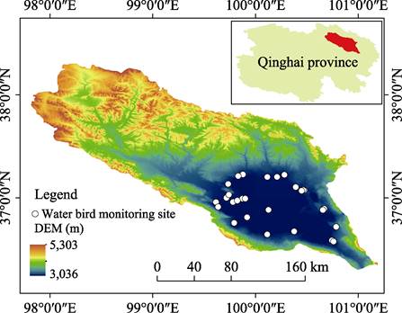
Figure 1 Distribution of sample sites
in the Qinghai Lake basin
lakeside salt
marsh, river floodplain, peninsula, and islands. The functional division of the
reserve area is divided into five types: the core area, buffer area, experimental
area, outside the protection area, and the protection zone boundary. According to the type and intensity of interference, grazing,
tourism, bird watching photography, no interference and weak, medium and strong
three intensity levels. The administrative division of the waterbird
monitoring sample point is clearly assigned to the township and town level.
4 Data
Results and Validation
4.1 Dataset Composition
This dataset includes the population number,
population dynamics, population distribution, and the population structure, and
the dataset is archived in .shp and .xls format, consists of two data files,
with a total size of 71 KB (compressed to 2 files, at 55.7 KB).
4.2 Data Results
In 2018, 57 bird species, six orders, and 12 families (Table 2),
including one kind of national key protection class I and three kinds of
national key protection class II, two new waterbirds monitoring records (Ardea
purpurea and Calidris minuta, Table 3), 32 waterfowl accounted for
56%; 25 wading birds accounted for 44%. A total of 72 waterfowl species were
recorded between 2013 and 2018, including 36 common species, 23 rare species,
and three new species. In 2018, ??Whether to reach or exceed 1% of the world
population distribution is an internationally important wetland??, there were 11 waterbirds that reached this index,
including one national-level protected bird. According to the data from 2014 to
2018, 10 species of waterfowl constituted the dominant species in Qinghai Lake.
There were three kinds of great black-headed gull, Larus ichthyaetus,
(including the brown-headed gull, Larus brunnicephalus), Bar-headed Goose Anser indicus and Great
Cormorant Phalacrocorax carbo, and non-cluster summer migratory birds have six
species of ruddy shelduck tadorna ferruginea, black-necked crane grus
nigricollis, tufted duck aythya fuligula, common pochard aythya ferina, tufted
duck aythya fuligula, red-crested pochard netta rufina and one species of
whooper swan cygnus cygnus in the wintering period.
Table 2 Species composition of
waterfowl in 2018
|
Order
|
Family
|
Species
|
Order
|
Family
|
Species
|
|
Ciconiiformes
|
Department of Pediatrics
|
4
|
Plovers
|
Charadriidae
|
5
|
|
Pelecaniformes
|
Phalacrocoracidae
|
1
|
Recurvirostridae
|
2
|
|
Storks
|
Ciconiidae
|
1
|
Scolopacidae
|
8
|
|
Ardeidae
|
5
|
6 Orders
|
Laridae
|
3
|
|
Ornithales
|
Gruidae
|
2
|
Sternidae
|
3
|
|
Ralline
|
2
|
12 Families
|
57 Species
|
|
Anserinales
|
Anatidae
|
21
|
|
|
Table 3 Added waterfowl
observations in 2018
|
Latin name
|
Observation time
|
Observational sample point number
|
Quantity (pcs)
|
|
Ardea purpurea
|
May 22nd
|
6301011001
|
1
|
|
May 23rd
|
6301011202
|
1
|
|
Calidris minuta
|
August 12th
|
6301012201
|
21
|
In 2018, the habitat interference degree of
waterbirds was the Heimahe river wetland, Daotanghe wetland, Erhai, Quanwan
wetland and Jiangxigou. The main interference types were tourism, bird
watching, and road traffic. Field surveillance was shown in Figure 2. Important
waterbird habitats not included in the protection area are Daotanghe wetland,
Hadatan, and Jiangxigou.
In 2018, the annual cumulative number of waterbirds in Qinghai Lake was
251,000, nearly 20,000 fewer compared with 2017. The total population of
waterbirds in Qinghai Lake between 250,000 was between 250,000 and 360,000 and
2018 (Table 4).
The 57,000 waterbirds recorded in late
October 2018 was the highest peak of the year. During spring migration,
waterbirds have 10 key habitats (Figure 3), namely Ganzi river wetland,
Hadatan, Naren wetland, Cormorant island, Egg island, Erhai, the Shaliuhe river
estuaries, Paerqiong wetland, Quanwan wetland, and Jiangxigou. The dominant species are the
great cormorant, Phalacrocorax carbo; the coot, Fulica atra; the
bar-headed goose, Anser indicus; the ruddy shelduck, Tadorna ferruginea; the
tufted duck, Aythya
fuligula; the common pochard, Aythya ferina; and the brown-headed gull, Larus brunnicephalus.
Table 4 Population dynamics of
waterfowl from 2014 to 2018
|
Year
|
Mar.
|
Apr.
|
May
|
Jun.
|
Jul.
|
Aug.
|
Sep.
|
Dec.
|
The next February
|
|
|
Spring migration period
|
Summer breeding period
|
Autumn migration period
|
Overwintering period
|
|
2018
|
16,695
|
20,203
|
46,332
|
45,001
|
23,961
|
31,514
|
57,792
|
8,582
|
1,178
|
|
2017
|
38,157
|
24,289
|
26,731
|
51,781
|
38,638
|
42,931
|
100,969
|
6,232
|
6,731
|
|
2016
|
25,350
|
41,673
|
27,107
|
35,751
|
18,196
|
55,176
|
43,832
|
3,245
|
21,177
|
|
2015
|
23,666
|
65,375
|
48,859
|
50,019
|
35,413
|
26,383
|
110,496
|
2,945
|
1,438
|
|
2014
|
21,540
|
53,268
|
32,016
|
43,010
|
32,482
|
55,333
|
114,342
|
3,434
|
1,434
|
The 10 key habitats are situated in
freshwater lakes, river floodplains, peninsulas, estuarine wetlands, marsh
meadows, and farmlands (Table 5).
Table 5 Spring migration period
in 2018
|
Order number
|
Location
|
Individual number
|
Number of species
|
Habitat type
|
|
1
|
Ganzi river wetland
|
1,148
|
26
|
Fresh water lake
|
|
2
|
Hadatan
|
3,626
|
21
|
Flood plain
|
|
3
|
Naren wetland
|
1,031
|
21
|
Marsh
|
|
4
|
Cormorant island
|
3,158
|
20
|
Lake shore peninsula
|
|
5
|
Egg island
|
1,381
|
19
|
Lake shore peninsula
|
|
6
|
Erhai
|
4,773
|
17
|
Fresh water lake
|
|
7
|
Shaliuhe river estuaries
|
510
|
16
|
Estuarine wetland
|
|
8
|
Paerqiong wetland
|
411
|
15
|
Estuarine wetland
|
|
9
|
Quanwan wetland
|
4,153
|
13
|
Marsh
|
|
10
|
Jiangxigou
|
2,894
|
6
|
Farmland
|
During the summer breeding period, waterbirds inhabit 12 key
habitats (Figure 3): Cormorant island, Egg island, the
Buhahe river estuaries, Hadatan, Quanwan wetland, Heimahe river wetland, Erhai,
the Shaliuhe river estuaries, Naren wetland, the Haergai river estuaries, Sankuaishi, and Haixinshan mountain. There are nine dominant species,
namely the great black-headed gull, Larus ichthyaetus; the great cormorant, Phalacrocorax carbo; the
bar-headed goose, Anser indicus; the common pochard, Aythya ferina; the tufted
duck, Aythya
fuligula; the red-crested pochard, Netta rufina; the brown-headed gull, Larus brunnicephalus; the
ruddy shelduck, Tadorna ferruginea; and the coot, Fulica atra. The five habitats are peninsulas,
estuarine wetlands, freshwater lakes, marsh meadows, and islands (Table 6).
During autumn migration, waterbirds inhabit
13 key habitats (Figure 3), namely Egg island,
Cormorant island, the Buhahe river estuaries, Paerqiong wetland, the Qiejihe
river estuaries, Hadatan, Quwan wetland, Heimahe river wetland, Daotanghe
wetland, Erhai, Jiangxigou, Xiaobohu, and Shadao. There are 11 dominant species:
the red-crested pochard, Netta rufina; the common pochard, Aythya ferina; the tufted
duck, Aythya
fuligula; the ruddy shelduck, Tadorna ferruginea; the coot, fulica atra; the mallard, Anas platyrhynchos; the
gadwall, Anas
strepera; the great cormorant, Phalacrocorax carbo; the common teal, Anas crecca; the pintail, Anas acuta; and the
whooper swan, Cygnus cygnus. The seven habitat types are peninsula, estuarine wetland, river
floodplain, swamp meadow, river wetland, freshwater lake, and farmland (Table
7).
During the overwintering period, there are
three Jiangxigou, Egg island, and Quanwan wetland (Figure 3).
The dominant species are the ruddy shelduck, Tadorna ferruginea; the
chicken- head diving duck; the red-necked duck, and
the magpie duck. During the winter, the three key waterbirds inhabit farmland,
peninsulas, and swamp meadows (Table 8).
Table 6 Summer breeding period
in 2018
|
Order number
|
Location
|
Individual number
|
Number of species
|
Habitat type
|
|
1
|
Cormorant island
|
2,291
|
9
|
Lake shore peninsula
|
|
2
|
Egg island
|
1,172
|
11
|
Lake shore peninsula
|
|
3
|
Buhahe river estuaries
|
17,988
|
7
|
Estuarine wetland
|
|
4
|
Hadatan
|
2,546
|
15
|
Flood plain
|
|
5
|
Quanwan wetland
|
7,625
|
16
|
Marsh
|
|
6
|
Heimahe river wetland
|
1,411
|
9
|
Marsh
|
|
7
|
Erhai
|
1,036
|
11
|
Fresh water lake
|
|
8
|
Shaliuhe river estuaries
|
2,304
|
16
|
Estuarine wetland
|
|
9
|
Naren wetland
|
10,115
|
22
|
Marsh
|
|
10
|
Haergai river estuaries
|
1,316
|
9
|
Estuarine wetland
|
|
11
|
Sankuaishi
|
23,317
|
5
|
Island in the lake
|
|
12
|
Haixinshan mountain
|
3,790
|
5
|
Island in the lake
|
Table 7 Autumn migration period
in 2018
|
Order number
|
Location
|
Individual number
|
Number of species
|
Habitat type
|
|
1
|
Egg island
|
17,850
|
14
|
Lake shore peninsula
|
|
2
|
Cormorant Island
|
9,444
|
4
|
Lake shore peninsula
|
|
3
|
Buhahe river estuaries
|
8,723
|
6
|
Estuarine wetland
|
|
4
|
Paerqiong wetland
|
8,013
|
2
|
Estuarine wetland
|
|
5
|
Chee estuary
|
6,487
|
11
|
Estuarine wetland
|
|
6
|
Hadatan
|
5,023
|
14
|
Flood plain
|
|
7
|
Quanwan wetland
|
3,768
|
10
|
Marsh
|
|
8
|
Heimahe river wetland
|
2,513
|
15
|
Marsh
|
|
9
|
Pour river wetland
|
2,154
|
10
|
Freshet
|
|
10
|
Erhai
|
1,644
|
17
|
Fresh water lake
|
|
11
|
Jiangxigou
|
1,619
|
4
|
Farmland
|
|
12
|
Xiao Bo lake
|
1,547
|
3
|
Marsh
|
|
13
|
Shadao
|
1,337
|
8
|
Fresh water lake
|
Table 8 Overwintering period in 2018
|
Order number
|
Location
|
Quantity
|
Number of species
|
Habitat type
|
|
1
|
Jiangxigou
|
4,957
|
2
|
Farmland
|
|
2
|
Egg island
|
2,752
|
6
|
Lake shore peninsula
|
|
3
|
Chee estuary
|
412
|
3
|
Estuarine wetland
|
|
4
|
Ganzi river wetland
|
233
|
3
|
Estuarine wetland
|
|
5
|
Quanwan wetland
|
208
|
3
|
Swamp meadow
|
|
6
|
Naren wetland
|
6
|
1
|
Swamp meadow
|
|
7
|
Gazhila wetland
|
4
|
1
|
Swamp meadow
|
|
8
|
Xiao Bo lake
|
10
|
1
|
Swamp meadow
|
In 2018, Qinghai Lake produced 44,000 summer
migratory birds (comprising the species of the great black-headed gull, Larus ichthyaetus; the
great cormorant, Phalacrocorax carbos; the bar-headed goose, anser indicus; and the
brown-headed gull, Larus brunnicephalus). In the peninsula habitat, the dominant
species are the great cormorant, Phalacrocorax carbos; the tufted duck, Aythya fuligula; and the
bar-headed goose, Anser indicus, etc. In the estuary wetland habitat, the dominant species are the
brown-headed gull, Larus brunnicephalus; the red-crested pochard, Netta rufina; the common
pochard, Aythya
ferina; Podiceps cristatus; the ruddy shelduck, Tadorna ferruginea; the
mallard, Anas
platyrhynchos; the gadwall, Anas strepera; and the common teal, Anas crecca, etc. In
island habitats, the dominant species are the ruddy shelduck, Tadorna ferruginea and the
brown-headed gull, Larus brunnicephaluss; the dominant species of other habitats
are not certain, so analysis was not done.
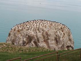

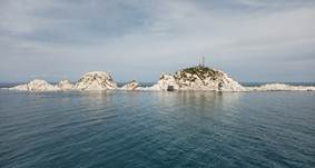
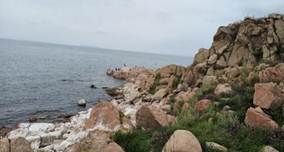
Figure 2 Field surveillance
shooting plots
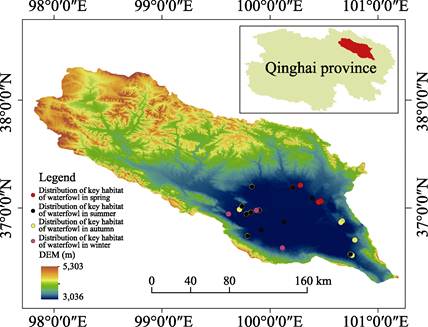
Figure 3 Major habitats
distribution for seasons
5 Discussion and Summary
During the 2018 summer breeding and autumn
migration periods, due to the inaccessibility to people and vehicles, the Buha
river estuary, Wuhaalanqu estuaries, Paerqiong wetland, and the Qiejihe river
estuaries led to incomplete monitoring sample site records. Due to the 2017
brown-headed gull, Larus brunnicephalus, camp site (Cormorant island), the camp nest
conditions were lost. No new brown-headed gull, Larus brunnicephalus, camp site was found during
monitoring, and only a few nest areas were found in the bird island area. The brown-headed gull, Larus brunnicephalus, breeding status was not recorded.
As Qinghai Lake waters rising wetland environment change, since 2016 appeared
several new waterbird habitat and waterbirds distribution is more concentrated
location, Naishiji Wetland (the old Hong Lake), Haergai river estuaries, Ganzi
river wetland, Erlangjian, Zhegeli Wetland, Nuraogeta Estuary, the above sites
in 2018 but was not formally included in the sample point monitoring, so
waterbird habitat monitoring is not comprehensive. Monitoring equipment and
means is not adapted to the current needs of waterbird monitoring, such as some
personnel and vehicles in an inaccessible habitat without effective means to
conduct monitoring work. Although efforts have been made to standardize the
monitoring of waterbirds, due to human factors, there is no unified and efficient
field patrol system.
In view of the drastic decline in waterbird
populations, further strengthen the patrol monitoring work real-time grasp of
waterbird dynamic changes and distribution, actively implement the wetland
protection and restoration project and reserve overall planning of ecological
restoration and ecological restoration project, make
the overall population of Qinghai Lake waterbirds stable. It is necessary to
actively respond to the adverse effects of waterbird nesting habitats due to
changing ecological environments, and to restore waterbird nesting habitats for
cluster breeding waterbirds. Qinghai Lake wintering waterbirds has formed from
the original swan as the main advantage species to latent duck and Ruddy
Shelduck Tadorna ferruginea as the advantage of the original wintering ground
(Quanwan wetland, Qiejihe river estuaries, Niaodao) to strengthen patrol
monitoring, the new wintering ground (Jiangxigou) wintering birds foraging land
award measures, retain the wintering and migratory waterbirds guarantee the
population of Qinghai Lake wintering birds. Law enforcement should be
strengthened to reduce the interference of no activities within a specific
period of time, to create a safe and quiet habitat for waterbirds. For
waterbird habitats not situated in protected areas, negotiations with local
government should be conducted to establish a ??community watch?? or jointly
carry out joint prevention and management with the community.
Author
Contributions
Ma, Y. X. and Chen, K. L. made a general design for the development of the
dataset. Hou, Y. S., Chen, Z. R., and Wang, X. Y. collected and processed all the data. Ma, Y. X. wrote
the data papers.
Conflicts
of Interest
The
authors declare no conflicts of interest.
References
[1]
Zhi, Y. J., Yi, J. F., Liu, W., et al. Wintering waterbird monitoring in Nanji
Wetland National Nature Reserve of Poyang Lake [J]. Chinese
Journal of Ecology, 2020, 39(7): 2400–2407.
[2]
Wang, Q., Lyu, X. G. Application of birds in wetland ecosystem monitoring
and evaluation [J]. Wetland Science,
2007(3): 274–281.
[3]
Wu, T. P., Zhao, Z. J., Luo, L., et al. Preliminary study on waterbird diversity
in Dashanbao Black- Necked Crane National Nature Reserve of Yunnan in winter [J]. Wetland Science, 2019, 17(3): 304–310.
[4]
Zhang, S. X., Dong, Y. X., Xia, F. Waterbird
monitoring significance of lake eco-system [J]. Journal
of Lake Sciences, 2011, 23(2): 155–162.
[5]
Delany, S. Guidelines for participants in the
international waterbird census (IWC) [J]. Wetlands
International, 2005, 1: 1–15.
[6]
Li, X. M., Cheng, R. M., Xiao, W. F., et al. Waterbird monitoring: History, current
situation and suggestions for future development in China [J]. Wetland Science, 2020, 18(6): 633–645.
[7]
Zhang, L. L., Gao, L. M., Chen, K. L. Variation characteristics of radiation balance and
surface albedo in Wayanshan wetland of Qinghai Lake basin [J]. Journal of Glaciology and Geo-Cryology, 2018,
40(6): 1216–1222.
[8]
Gao, L. M., Zhang, L. L., Chen, K. L. Microclimate characteristics of wetland in Qinghai Lake
basin [J]. Journal of Arid
Zone Research, 2019, 36(1): 186–192.
[9]
Cairen, Z. M. Legal research on
wetland ecosystem protection in Qinghai Lake [J].
Lanzhou: Lanzhou University, 2016.
[10]
Hou, Y. S., He, Y. B., Xing, Z., et al. Diversity and distribution of waterbirds
in Qinghai Lake National Nature Reserve [J]. Acta
Zootaxonomica Sinica, 2009, 34(1): 184–187.
[11]
Chen, Z. R., Sun, J. Q., Hou, Y. S., et al. Waterfowl habitat and migration
dataset collecting from 30 sample sites in Qinghai Lake basin (2018) [J/DB/OL].
Digital Journal of Global Change Data
Repository, 2021. https://doi.org/10.3974/geodb.2021.10.01.V1.
https://cstr.escience.org.cn/CSTR:20146.11.2021.10.01.V1.
[12]
GCdataPR
Editorial Office. GCdataPR data sharing policy [OL]. https://doi.org/10.3974/dp.policy.2014.05
(Updated 2017).