Innovation of Geography Driven by Artificial Intelligence _Big Data_Cloud Computing—The 15th Seminar on Communications of Big Geographic Data in 100 Universities at Zhejiang University
Zhang, F.1* Liu, Q. H.2
1. School of Geosciences, Zhejiang University, Hangzhou 310058, China;
2. Institute of Remote Sensing and Digital Earth, Chinese Academy of Sciences, Beijing 100101, China
Artificial Intelligence, Big Data, and Cloud Computing (A·B·C) are hot topics in the field of science and technology. The Geographical Society of China (GSC) established the Big Geographical Data Working Committee (GSC_BigData) in 2018. The Data Computing Environment working group (WGCE) is one of the seven working groups of the GSC_BigData. Its main task is to enhance the big data computing environment for geographical data re-using and discovery. As a new filed of the big data computing environment, its priorities, challenges and solutions in institutional level were identified.
|
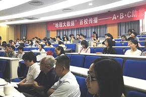
Figure 1 The 15th Seminar on Communications of Big Geographic Data in 100 Universities was held in Zhejiang University, Hangzhou, China
|
For meeting the urgent needs from research, education, and decision-making, the 15th Seminar on Communications of Big Geographic Data in 100 Universities was held focused on Innovation of Geography by Artificial Intelligence_ Big Data_Cloud Computing on September 17, 2018 in Zhejiang University, Hangzhou, China (Figure 1). Before that, there were 14 seminars in Beijing, Ji’nan, Yinchuan, Xi’ning, Guangzhou of China and University of Antananarivo, Madagascar.
The 15th seminar was co-organized by GSC and the Institute of Geographic Sciences and Natural Resources
Research, Chinese Academy of Sciences (IGSNRR/CAS), supported by the Department of Communication Bureau of Chinese Academy of Sciences and hosted by the School of Geosciences of Zhejiang University, and the Geographical Society of Zhejiang Province, China.
Prof. Zhang, F. moderated the seminar and Prof. Xia, Q. K. delivered the welcome speech. He indicated that the Earth Science School of Zhejiang University was one of the most leading schools in earth sciences of China. There were four departments in the school, including departments of atmospheric sciences, geology, geography, and geo-information science and technology. The history of School of Earth Sciences could be traced back to 1936 when the prominent Chinese meteorologist, geographer, and educator Chu Kochen founded the Department of History and Geography in the National Chekiang University (the predecessor of Zhejiang University). The reformed Department of Earth Sciences was established in 1999 through the integration of Department of Earth Sciences of the former Zhejiang University and the discipline of geography and meteorology of the former Hangzhou University. Department of Earth Sciences was expanded to School of Earth Sciences in 2015. Now, the School of Earth Science of Zhejiang University has become one of the high impact school in earth sciences of China.
Professors Liu, C., Liu, Q. H., Xiao, Q., and Xia, Q. K. presented the updated achievements from strategical, technical, practical and local application dimensions on big geographical data. In particular, Prof. Liu, C., on behalf of the GSC and IGSNRR/CAS, congratulated the platform A distributed spatial-temporal data model and online analyst system for marine environmental research developed by Zhejiang University for being honored the Best Practice Data Computing Environment 2018 by GSC (Figure 2).
Figure 2 The Spatial-temporal distributed computing environment for marine carbon flux research developed by Zhejiang University was honored the Best Practice Data Computing Environment 2018 by Geographical Society of China
|
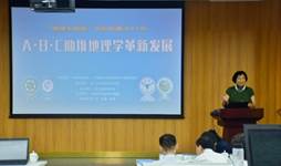
Figure 3 Prof. Liu, C. delivered her presentation on Geography in the Era of Big Data
|
Prof. Liu, C. is the Principle Investigator of the National Science Communication on Geography of the World, Secretary General of the GSC_BigData and Prof. of IGSNRR/CAS. She indicated at her presentation on Geography in the Era of Big Data that data were the fundamental resource and accelerator for geographical discovery and had benefit to the sustainable development (Figure 3).
She emphasized that data publishing was the key for the data sharing, and the Global Change Research Data Publishing & Repository (GCdataPR) established by the IGSNRR/CAS and GSC provided services for the data publishing and sharing. It was recognized as an innovation way for accelerating the modern geography in the era of big data. She emphasized that the data intellectual property protection, data security, data quality, data standards, data timeliness, data repository and long-term archiving and accessible, data interactive, data re-using, data computing, data value added services, and even more new challenges made the big geographical data more completed. Education and communication on big geographical data became the urgent need. The program on Seminar on Communications of Big Geographic Data in 100 Universities is meeting such a need.
|
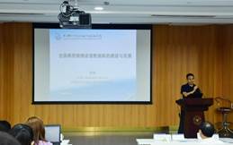
Figure 4 Prof. Xiao, Q. delivered his presentation on Establishment and Development of National Typical Ground-objects Spectrum Database
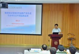
Figure 5 Prof. Liu, Q. H. delivered his presentation on Generation of Common Remote Sensing Product for Earth Comprehensive Observation and Global Ecological Environment Monitoring
|
Prof. Xiao, Q. from the Institute of Remote Sensing and Digital Earth of Chinese Academy of Sciences presented how to use the ground-objects spectrum database for remote sensing data mining and quality control. His report on Establishment and Development of National Typical Ground-objects Spectrum Database attracted special attention from attendees (Figure 4).
By re-using the data, one can measure full-band ground-object spectrum, fixed-
point long time series and multi-scale ground-object spectrum, and establish characteristic data sets. The ground-object spectrum database can be applied to more fields, such as assistant classification of ground objects, parameterization of the remote sensing mechanism model and so on.
Prof. Liu, Q. H. is Vice Chair of the GSC_BigData and Chair of the WGCE, Deputy Director of the State Key Laboratory of Remote Sensing Science, and Prof. of the Institute of Remote Sensing and Digital Earth, Chinese Academy of Sciences. He indicated in his presentation on Generation of Common Remote Sensing Product for Earth Comprehensive Observation and Global Ecological Environment Monitoring that data computing environment was crucial for new dataset development and discovery (Figure 5).
He took the Multi-source data Synergized Quantitative remote sensing production system (MuSyQ) as an example to demonstrate how the computing environment could play such important role. This system normalized 18 datasets and produced more than 20 bio-geophysical parameters. Up to date, 358 TB of original remote sensing data have been collected and 450 TB of normalized data and bio-geophysical parameters have been produced. These data include six years’ global data (2010-2015) with resolution lower than 1 km and one year’s data with 30 m resolution of China and Southeastern Asia. The MuSyQ was honored the Best Practice Data Computing Environment 2018 by GSC.
Prof. Li, R. Y., Director General of the Geographical Society of Zhejiang Province, reported on Innovation Technology and Practice of Geospatial Information Service in the Intelligent Age at the seminar (Figure 6). He took Institute of Geographic Information Science of Zhejiang University as an example to explain that geography had entered a new stage of geospatial-temporal big data. With such recognition and responsibility, the Institute of Geographic Information Science of Zhejiang University had developed key innovative technologies in the field of geospatial-temporal big data.
|
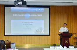
Figure 6 Prof. Liu, R. Y. delivered his presentation on Innovation Technology and Practice of Geospatial Information Service in the Intelligent Age
|
The Spatial-temporal distributed computing environment for marine carbon flux research is an example in practice how to develop a trustable and practical data
computing environment for supporting scientific discoveries. Multiple sources data in TB level were integrated with the analysis models in the computing environment. The environment is consisted computer server, model system, software system, data
networking, data processing ability, data computing ability and online data dissemination. A series of findings already published, such as Eutrophication-driven Hypoxia in the East China Sea off the Changjiang Estuary, and Diurnal variability of turbidity fronts observed by geostationary satellite ocean color remote sensing. The Spatial-temporal distributed computing environment for marine carbon flux research was honored the Best Practice Data Computing Environment 2018 by GSC.
Prof. Xia, Q., Dean of the Earth Science School, Prof. Zhang, F., Deputy Director of Geoinformatics Institute, Prof. Du, Z. H., Deputy Director of Department of Geography, Associate Prof. Lu, L. Z. of Zhejiang University, Prof. Li, R. Y., President of Geographical Society of Zhejiang province, Zhang, X. P., Secretary General of Geographical Society of Zhejiang province, Mr. Wan, F. from Science Press and more than a hundred students, Professors and scientists joined the successful seminar.
Introduction of School of Earth Sciences, Zhejiang University
The predecessor of the School of Earth Sciences (SES) in Zhejiang University is the
Department of History and Geography in National Chekiang University, founded in 1936 by Mr. Chu Kochen, a prominent meteorologist, geographer, and educator. Since 1949, Chinese higher education systems have experienced a serial of restructuring based on the education model of the former Soviet Union. The new Department of Earth Sciences was established within Faculty of Science of Zhejiang University (ZJU) in 1999 through the integration of Department of Earth Sciences of the former ZJU and the disciplines of geography and
meteorology of the former Hangzhou University. The Department of Earth Sciences was expanded to the School of Earth Sciences in 2015. Over last 80 years, the School of Earth Sciences in ZJU has grown into a highly interdisciplinary academic institute. The mission of SES is to understand and predict the behavior of the Earth systems, including the lithosphere, atmosphere, hydrosphere, cryosphere, biosphere, and their interactions with human activities at local to global scales. The School of Earth Sciences also aims to educate the next generation Earth scientists and provides decision-relevant insights that benefit the society.